


Dakota Aquifer Program--Water Quality
Water Quality Effects in Surface Water
Regional flow discharges from the confined Dakota aquifer and
underlying Cedar Hills Sandstone aquifers in the river valleys
of central where they cross the outcrop of the Dakota Formation
in north-central Kansas. The discharge areas for the smaller,
but vertically-extensive local flow systems also coincide with
these regional discharge areas. As a result the deeper more
saline ground waters are discharged back to surface because of
the combined effects of these flow systems. Salt marshes
associated with saltwater discharge to surface water are common
features in the Saline, Solomon, and Republican river valleys
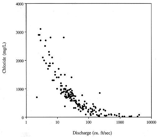
(Figure 7). During low flow periods when baseflow constitutes
the bulk of stream discharge, the chloride concentration of
surface waters escalates rapidly (Figure 8). Elsewhere, freshwater
is discharged from the upper Dakota to the Arkansas, Pawnee,
and Wet Walnut drainages.
Figure 7. Location of salt marshes in Central Kansas. Many
of these features are associated with discharge from the Dakota aquifer.
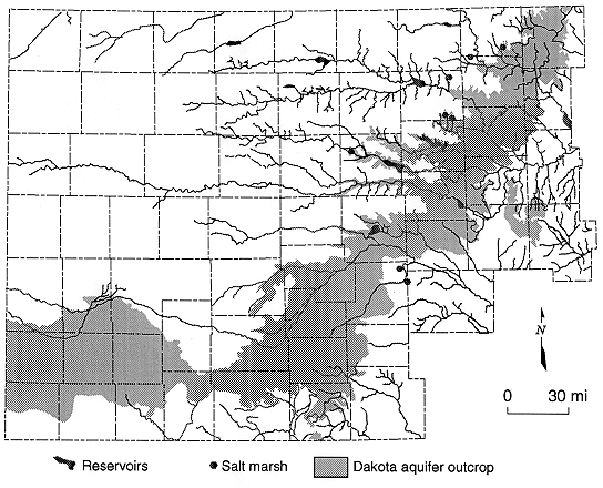
Figure 8. Discharge vs. chloride concentration for the Saline
River north of Russell, Kansas.
Previous Page--Vertical Changes in Water Quality
Dakota Home ||
Water Quality Index
Kansas Geological Survey, Dakota Aquifer Program
Updated July 5, 1996.
Scientific comments to P. Allen Macfarlane
Web comments to webadmin@kgs.ku.edu
The URL for this page is HTTP://www.kgs.ku.edu/Dakota/vol1/water/water05.htm