In his reconnaissance of the Great Plains, Darton (1905, 1906) found widespread use of the Dakota for drinking water, steam locomotives, and non-irrigated agriculture. Flowing wells were very common in the Arkansas River valley of southeastern Colorado, in much of South Dakota, and parts of southeastern North Dakota and northeastern Nebraska in the Missouri River valley at that time. The artesian pressure within the aquifer in these areas was sufficient that many of the wells produced an adequate supply of fresh water without the use of a pump.
In the Arkansas River valley of southeastern Colorado, the depths of these flowing artesian wells ranged from more than 1,000 ft at Pueblo and Fowler, Colorado, to 300 ft at Coolidge, Kansas. Darton found considerable artesian pressure in many of the wells he visited. He estimated that in some cases if the well casing were extended up into the air, the water levels would rise from a few feet up to 150 ft above land surface. Flow rates ranged from less than one up to more than 100 gallons per minute.
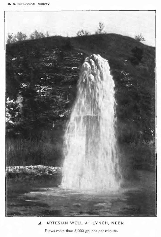
Figure 1 is a photograph of one of the flowing artesian wells visited by Darton in the early 1900s. The water levels in the first flowing artesian Dakota wells at Coolidge, Kansas, in 1885 were estimated to be almost 20 ft above land surface. In the early 1900s local well owners could expect flows from wells tapping the Dakota aquifer to range from 25 to 75 gallons per minute in the Arkansas River valley between Coolidge and Syracuse. Later in the 1930s and early 1940s, the flow rates from these wells decreased to 30 gallons per minute or less in this same stretch of the valley.
Figure 1--From Darton (1905), flowing artesian well.
Many of the wells that Darton inventoried in the Arkansas River valley did not flow naturally to the surface. Water levels were generally 75 ft or less below land surface eastward of Lamar, Colorado. Darton reported that some of the artesian pressure had been lost due to pumping and unregulated, year-round discharge from the flowing artesian wells. If a well did not flow naturally under artesian pressure, steam- or wind-power was needed to bring water to the surface. Well yields were reported to range from 25 to 80 gallons per minute. Now, the flowing artesian wells that once were commonplace in the Arkansas River valley are rare where historic development was heaviest.
On the basis of a handful well-drilling reports from across western and central Kansas, Haworth (1913) outlined an area where the Dakota is shallow and could be practically used for water supply. This area included most of the Arkansas River drainage above Great Bend, Kansas and a portion of the Cimarron River basin. Haworth also observed freshwater springs emanating from the hillsides in central Kansas. He reported that they were fed locally by the Dakota aquifer where it is at the surface, but did not report on their use by the local population for water supply.
However, the attention of users has been largely focused on the shallower and more prolific sources of water in the High Plains aquifer and in the river valleys of Kansas. In the last few decades, the shallower sources of water have been under intense development primarily from irrigated agriculture. As a result, water levels in these shallow aquifer systems have declined significantly. In several instances these sources now are insufficient to meet existing demand in local areas. During this period, the competition for water stimulated interest in tapping deeper sources in the Dakota aquifer in western Kansas to supplement yields from the dwindling shallower sources.
In the late 1970s, a regional study of the Dakota aquifer by the Kansas Geological Survey estimated that 8095 million acre-ft of water with a total dissolved solids concentration of less than 3,000 mg/L could potentially be withdrawn from the Dakota. However, it was recognized that development of water resources for irrigation of crops could be limited due to the complexity of the Dakota.
In southwestern Kansas, the institution of new management policies for the High Plains aquifer sparked interest in the Dakota as a source of water for irrigating crops. New management policies and regulations were developed and instituted by Southwest Groundwater Management District #3 that applied to both the High Plains and the Dakota aquifers. These policies and regulations were based on a limited quantitative understanding of the hydrologic interactions between the Dakota and the overlying High Plains aquifer in the District. The new regulations featured a graduated well spacing based on the yearly withdrawal of ground water from the well to be installed.
In north-central Kansas at about this time, limited use of the Dakota aquifer for irrigating crops in southwestern Washington and adjacent Cloud and Republic counties also began and has continued to the present. The only guidelines applied to this development stipulated a well spacing of one mile between these high-yield wells.
Darton, N.H., 1905, Preliminary report on the geology and underground water resources of the central Great Plains: U.S. Geological Survey Professional Paper 32, 433 p. [available online]
Darton, N.H., 1906, Geology and underground water resources of the Arkansas valley in eastern Colorado: U.S. Geological Survey Professional Paper 52, 90 p. [available online]
Haworth, E., 1913, Special report on well waters in Kansas: Kansas Geological Survey Bulletin 1, 110 p. [available online]
Previous Page--Steady-state Ground-water Flow ||
Next Page--Sustainability
Dakota Home ||
Start of Report
Kansas Geological Survey, Dakota Aquifer Program
Updated July 1996.
Scientific comments to P. Allen Macfarlane
Web comments to webadmin@kgs.ku.edu
The URL for this page is HTTP://www.kgs.ku.edu/Dakota/vol1/hydro/watdev.htm