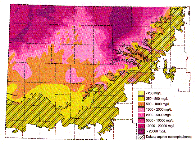
Figure 6. Distribution of total dissolved solids (TDS) concentrations in ground waters in the upper Dakota aquifer in western and central Kansas. Water less than 1000 mg/L TDS is defined as fresh. Water with 1000-2000 mg/L TDS is usable for many purposes but is less desirable than freshwater. A concentration of 10,000 mg/L TDS is defined in the state regulations of the Kansas Corporation Commission as the upper limit of usable water; above 10,000 mg/L a water is classified as unusable or mineralized.
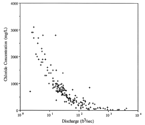
The potentiometric surface map in Figure 3 indicates that the hydraulic head in the Dakota aquifer is lower in north-central Kansas than elsewhere. Beneath most of the river valleys, the hydraulic head in the Dakota is higher than the water level in the streams and may be higher than the land-surface elevation. This suggests that ground water in the Dakota is moving toward these river valleys from elsewhere in the region and discharging to streams or to the surface along the sloping valley sides. In the outcrop areas, the flow system in the Dakota is influenced by both regional flow from the confined Dakota to the west and local flow systems that result from local topographic relief. These local systems are replenished by infiltration of local recharge which may be discharged from the aquifer a short distance away. Also, pumping test results suggest that the Dakota is generally more permeable in this region than it is to the west. Computer simulations of the steady-state flow system indicate that the flux of fresh water through outcrop/subcrop belt is at least four times higher than in the confined aquifer to the west (Macfarlane and Smith, 1994; Wade 1992). In the Washington County area, Wade (1992) estimated the annual recharge to the Dakota to be on the order of 0.25 in. where it is unconfined. As a result, fresh and saline water springs and seeps can be found in the river valleys. Salt marshes associated with discharge to surface water are common features in the Saline, Solomon, and Republican River valleys of central Kansas (Figure 7). During low flow periods when baseflow constitutes the bulk of stream discharge, the chloride concentration of surface waters escalates rapidly (Figure 8). Elsewhere, the freshwater is discharged from the upper Dakota to the Arkansas, Pawnee, and Wet Walnut drainages (Smith and Macfarlane, 1994).
Figure 7. Location of salt marshes in central Kansas. Many of these features are associated with discharge from the Dakota aquifer.
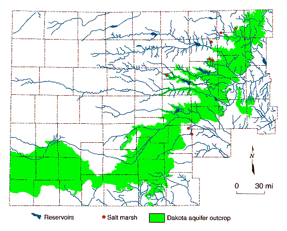
Figure 8. Steream discharge vs. chloride concentration at the Saline River gaging station north of Russell, Kansas.
Previous Page--Dakota Flow ||
Next Page--Temperature Logging Introduction
Dakota Home ||
Start of Report