Figure 3. Elevation in feet above mean sea level of the predevelopment potentiometric surface of the Dakota aquifer in southeastern Colorado and western Kansas. The shaded area shows the area of outcrop, primarily in central Kansas, and subcrop beneath Pleistocene and Tertiary deposits in southwestern Kansas and southeastern Colorado. Hydraulic head data are from the U.S. Geological Survey's Central Midwest Regional System Analysis Program.
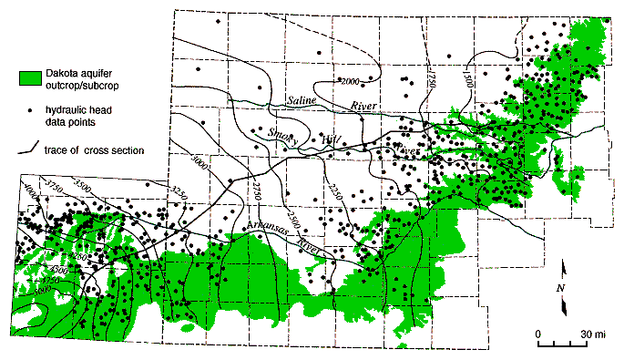
The Dakota potentiometric surface map in Figure 3 shows that the hydraulic head in the Dakota aquifer is higher to the south of the Arkansas River than elsewhere to the north and east. On the map the equipotentials are arranged concentrically around a hydraulic head maximum and decrease rapidly to the north and east of this region. This indicates northeastward flow away from an area of recharge to the Dakota aquifer. The total recharge from precipitation depends on the downward movement of water below the root zone to the water table or seepage into exposed bedrock outcrops. Within this recharge area in southeastern Colorado a part of the Dakota aquifer underlies and is hydraulically connected to the High Plains aquifer. The total amount of seepage downward into the Dakota from the High Plains depends on the hydraulic connection between the two aquifers and the hydraulic head gradient. In Figure 4, most of the recharge to the Dakota is intercepted by local shallow flow systems that discharge back to the surface drainage within the recharge area (Macfarlane, 1995). Consequently, the age of ground water in this part of the system is generally less than 10,000 yrs (Macfarlane et al., 1995).
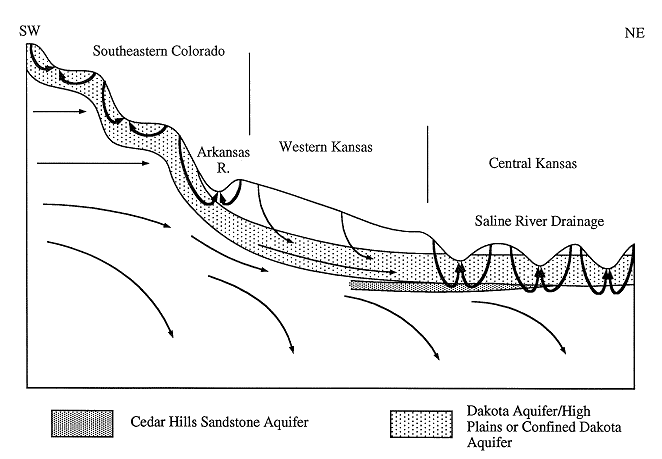
Figure 4. A conceptual model of ground-water flow through the confined Dakota aquifer from the regional recharge area in southeastern Colorado to the reginal discharge area in central Kansas. The trace of the cross-section is shown on Figure 3. Most of the recharge to the Dakota aquifer is routed back to the surface by local flow systems in central Kansas and saoutheastern Colorado.
Locally in this part of the Arkansas River valley, some wells tapping the Dakota flowed at the surface where the potentiometric surface was above land surface. McLaughlin (1954) outlined an area where flowing artesian wells were concentrated in the Bear Creek drainage north of Walsh, Colorado, and referred to this part of the drainage as the Walsh artesian area. Darton (1906) outlined a large part of the Arkansas River valley where flowing artesian conditions existed from Syracuse, Kansas, up river to the vicinity of Pueblo, Colorado.
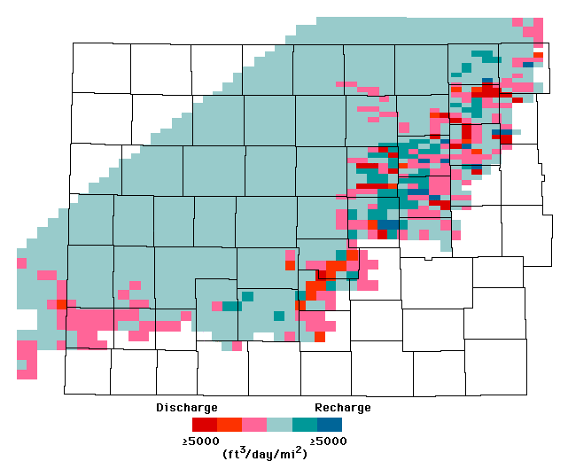
Only about 10% of the infiltrated water entering the aquifer moves downdip from the recharge area south of the Arkansas River into the confined Dakota in western Kansas and southeastern Colorado (Figure 3 and 4; Macfarlane, 1995). Within the confined aquifer, the ground-water moves slowly northeastward towards the regional discharge area in central Kansas due to low aquifer transmissivity (Macfarlane, 1993). Over most of western Kansas, the vertical hydraulic conductivity of the overlying Upper Cretaceous aquitard is very low, on the order of 1 x 10⁻⁷ ft/day or less (Macfarlane, 1993; Belitz and Bredehoeft, 1988). Freshwater recharge to the confined Dakota is negligible, less than 0.1% of the lateral flow within the aquifer (Figure 5). Most of the freshwater recharge to the confined Dakota enters where the aquitard is relatively thin and dissected near the outcrop/subcrop areas. Here, the vertical hydraulic conductivity is two to three orders of magnitude higher and recharge from overlying sources may amount to as much as 10% of the lateral flow within the aquifer (Smith and Macfarlane, 1994; Smith, 1995). In central Kansas, an additional source of recharge to the Dakota comes from the underlying Cedar Hills Sandstone where both aquifers are hydraulically connected (Figure 4). The total recharge from this source amounts to less than 1% of the lateral flow in the upper Dakota aquifer.
Figure 5. Recharge to and discharge from the Dakota aquifer in units of cubic feet per day per square mile.
Previous Page--Steady-state Flow System ||
Next Page--More on Dakota Flow
Dakota Home ||
Start of Report