Table 2--Architecture element data from Saline River and Wilson Lake, Ruessell. Showing exposure locations, element geometry, thickness, width, lithofacies-fill, paleocurrent data, and numbers of measurements.
| Location | Architecture element |
Geometry | Thickness (m) | Width (m) | Lithofacies | Paleocurrent (average) |
|---|---|---|---|---|---|---|
| 1d | CH | Lens | 1.3 | 7.8 | Fm | N49.3E; n=25 |
| CH | Lens | 2.1 | 25.3 | Sp | ||
| OF | Sheet | 5.1 | >25.5 | Fm, Fl | ||
| SB | Sheet | 1.4 | >25.5 | Sr, Sp | ||
| 2d | CH | Lens | 4.6 | >18.2 | St | N13.5W; n=10 |
| CH | Lens | 3.6 | 35.6 | St | N24.9W; n=8 | |
| CH | Lens | 2.5 | 34 | Fl | ||
| FM | Lens | 1.1 | 2.5 | Sp | N12.5W; n=6 | |
| OF | Sheet | 2.1 | >43.3 | Fl | ||
| CH | Lens | 1.5 | >7.8 | Sp, St | S35.4E; n=7 | |
| SB | Sheet | 0.5 | 15.3 | Sr | ||
| CH | Lens | 1.8 | 16.4 | Fl, Fm | ||
| OF | Sheet | 1.2 | 33.1 | Fl | ||
| SB | Sheet | 2.1 | >3.7 | Sp, Sr | N17.8W; N=6 | |
| CH | Lens | >2.1 | >6.7 | St | S85.5W; n=5 | |
| CH | Lens | 1.3 | >4.3 | Fm | ||
| CH | Lens | 2.5 | 21.1 | St | S41.4E; n=8 | |
| S1 | CH | Lens | >0.8 | 12.7 | Sp | N70.4W; n=24 |
| LA | Lobe | 2.4 | 18.8 | Sp, St | N5.3W; n=21 | |
| SB | Sheet | 1.8 | >9.5 | Sp, Sr | N67.4W; n=16 | |
| S2 | CH | Lens | 0.7 | >3.5 | Sp, St | |
| S3 | CH | 0.6 | >2.4 | Sp | ||
| S4 | OF | Sheet | 1.2 | >3.1 | Sp |
| Location | Architecture element |
Geometry | Thickness (m) | Width (m) | Lithofacies | Paleocurrent (average) |
| S5 | OF | Sheet | 1.5 | 15.6 | Fl, Fm | |
| CH | Lens | 1.8 | >11.4 | Fm | ||
| SB | Wedge | 1.2 | 14.6 | St, Sr | ||
| S6 | CH | Lens | 0.6 | >5.7 | Sp, Sr | N10.7E; n=27 |
| OF | Sheet | 3.5 | 10.2 | Fm | ||
| S7 | CH | Lens | 3.5 | 50 | Sp, Se | N54.4W; N=43 |
| SB | Lobe | 1.2 | 5.6 | Sp | ||
| FM | Lens | 1.8 | 15 | Sp, Sr | ||
| LA | 4.5 | >17.8 | Sp, Ss | |||
| CH | Lens | 2.3 | 15 | St | ||
| S8 | OF | Sheet | 11.2 | >12.3 | Fl | |
| S9 | OF | Sheet | 16.1 | >130 | Fm | |
| CH | Lens | 3.7 | 46.8 | St | N8.5E; n=14 | |
| OF | Sheet | 11.2 | >170 | Fl, Fm | ||
| OF | Sheet | 5.1 | >170 | Fl, Fm | Red soil | |
| OF | Sheet | 2.2 | 158 | Fm | ||
| CH | Lens | 2.4 | 28 | St, Sp | S15.5E; n=15 | |
| SB | Sheet | 1.5 | 38.2 | Sp, Sr | ||
| CH | Lens | 4.6 | 34.5 | Fm, Fl | ||
| S10 | CH | Lens | >4.1 | >10 | St | S15.5E; n=15 |
| CH | Lens | >3.2 | >7 | St | N80.7W; n=19 | |
| OF | Sheet | >3 | 58.5 | Fm | ||
| CH | Lens | 2.3 | 20.2 | Fl | ||
| OF | Sheet | 12.3 | >320 | Fl | ||
| OF | Sheet | 5.9 | >74.8 | Fm | ||
| SB | Sheet | 0.6 | 7.5 | Sr |
| Location | Architecture element |
Geometry | Thickness (m) | Width (m) | Lithofacies | Paleocurrent (average) |
| S12 | OF | Sheet | 4.3 | >10.6 | Fm | |
| S13 | OF | Sheet | 3.5 | 149 | Fm | |
| S14 | CH | Lens | 1.5 | >7 | Sp | |
| OF | Sheet | 2.7 | >15.9 | Fm | ||
| S15 | FM | Lens | 0.5 | 3.2 | Sp | S52.6E; n=18 |
| CH | Lens | 4.4 | 36 | SP | ||
| LA | Lens | 4.4 | 23.8 | St | ||
| CH | Lens | 2.5 | 28 | Sp | S10.2E; n=22 | |
| W1 | CH | Lens | 2.2 | >8.5 | Sp, Sr | N67.8E; n=24 |
| W2 | CH | Lens | 1.5 | 32 | Sp | N0.4W; n=27 |
| W3 | FM | Lens | 4.8 | 17.8 | Sp | S62.8W; n=26 |
| W4 | CH | Lens | 2.7 | 25 | Sp | |
| FM | Lens | 2.8 | 15 | Sp, Sr | N9.1W; n=27 | |
| W5 | OF | Sheet | 5 | >4.9 | Fl | |
| FM | Lens | 2.8 | 15 | Sp, Sr | N9.1W; n=27 | |
| W6 | CH | Lens | 6.5 | >28.5 | St | S75.6W; n=24 |
| W7 | OF | Sheet | 1.5 | >20.4 | Fm | |
| W8 | LA | Lobe | 9.5 | 38.2 | Sp | N78.9W; n=32 |
| W | SB | Sheet | 3.2 | 3.5 | Sp | |
| SB | Sheet | 2.1 | 21.5 | Sp, Sr | N80.6W; n=20 | |
| SB | Sheet | 1.2 | 8.5 | Sp, Sl | ||
| CH | 2.8 | >8.5 | Sp, St | |||
| Kanopolis | CH | Lens, Sheet | N65.8W |
Table 3--Summary of architecture element data in Saline River and Wilson Lake, Russell. X = mathematic mean, Y = standard deviation.
| Architecture Element |
Geometry | Range of Thickness (m) |
Range of Width (m) |
P(A) as probablility of element |
Facies |
|---|---|---|---|---|---|
| CH | Lens, Sheet | 0.6-6.5 x=2.51 y=1.85 |
2.4- >50 x=27.55 y=124.73 | 0.44 | St, Sp, Fm, Fl, Ss, Sr |
| OF | Sheet | 1.2-16.1 x=5.31 y=18.46 |
2.4-320 x=53.28 y=2574.5 | 0.27 | Fm, Fl |
| SB | Sheet, Lobe Wedge |
0.02-3.2 x=1.64 y=0.71 |
3.5-38.2 x=13.29 y=108.39 | 0.17 | Sp, Sr |
| LA | Lens, Lobe | 2.4-9.5 x=5.2 y=6.87 |
8.5-38.2 x=26.9 y=67.6 | 0.06 | Sp, Sr, St |
| FM | Lens | 0.5-4.8 x=2.3 y=2.8 |
2.5-17.8 x=9.6 y=46.94 | 0.06 | Sp |
Channel-fill elements occupy approximately 30% of examined outcrop area, and appear as concave-up lens with erosional base (Figure 2). Individual channel-fill elements range from 0.6-6.5 m thick and 2.4-50 m wide, with width/depth ratios commonly between 10 and 20. Lateral accretion, overbank-fine, and sandy-bedform elements are commonly adjacent to channel-fills. Channel-fill elements may exist as independent lenses surrounded completely by lateral-accretion, overbank-fine, and/or sandy-bedform elements (Figure 2); however, they are more typically vertically and laterally amalgamated to varying degrees with other CH elements, with these other elements occupying the remaining boundary area (Figure 2).
Figure 2--Eight architectural elements associated with fluvial strata (from Miall, 1985).
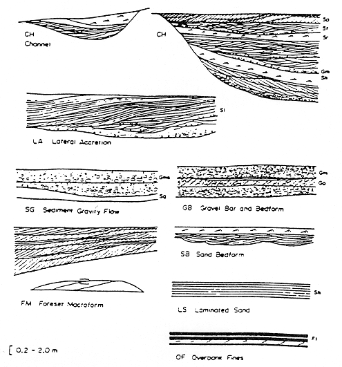
Channel-fill elements comprise a variety of fill types, with approximately 75% of observed channels being filled almost entirely by sandstone lithofacies, and the remaining portion being filled entirely or dominantly by mudstone lithofacies. Lithofacies in dominantly sandstone-filled elements include lithofacies Sp (Sandstone, planar cross bedded; 50%), St (Sandstone, trough cross bedded; 40%), Ss, Se and Sr (SS, Se, and Sr collectively 10%) (Table 2). Cross-bedding in lithofacies Sp and St is small to medium-scale, with individual sets, ranging from about 6 cm to slightly 1.2 m and averaging about 34 cm in thickness. Most cross-bed sets are several meters in width. Paleocurrent data from cross-bed sets indicate a northwest flow trend for sandstone-dominate channel fill elements (Table 2; Appendix C).
Filling of sandstone-dominated channel-fill elements by above described sandstone lithofacies implies that migration of sand in dunes and other sandy bedforms persisted throughout the filling of parent channels. This infers maintenance of relatively high-energy flow in the channel as discharge waned, and the channel bottom aggraded. These "active-channel-fill" elements most likely reflect filling of channels while primary flow gradually shifted into a new channel, and discharge was proportionally reduced in the old channel. Similar gradual abandonment processes have been cited previously as a mechanism for generating analogous coarse-grained channel fills (Fisk, 1955, Hopkins, 1985).
About 25% of observed channel-fill elements are composed predominately of mudstone lithofacies. Most of these fills are almost entirely either Fm (Mudstone, massive) or Fl (Mudstone, laminated ) lithofacies (Figure 3, Table 2); however, approximately 70% of these mudstone-dominated fills are composed of these same mudstone lithofacies interbedded with up to 20% thin to very thin beds of laminated to rippled siltstone and fine sandstone. Mudstone-dominated channel-fill elements have similar geometry and dimension as sandstone-dominated channel fills.
Abundant fine sediments in these mudstone-dominated channel-fill elements infers isolation of the parent channel from active stream flow through abrupt abandonment in the early stages of channel filling. Completion of channel filling could then occur under comparatively low-energy conditions during overbank events. Most of these channels are filled entirely by mudstone, indicating probable filling of channels as oxbow lakes on a floodplain following complete abandonment through neck cutoff (Allen, 1965). In some cases, periodic reoccupation of channels following abandonment has resulted in alternative deposition of silty and sandy components between more typical quietwater mud deposition, a feature more representative of channels filled after abandonment by chute cutoff (Allen, 1965).
Overbank fine elements are abundant, and occupy approximately 50% of described outcrop area. Sharp surfaces across which color changes abruptly are common in these overbank strata, and are interpreted to represent preservation of Dakota paleosols (Figure 4). These paleosols represent substantial gaps in overbank mudstone deposition, and were here used to define boundaries of individual overbank-fine elements. Boundaries of overbank-fine elements were also defined where overbank-fine strata were in direct contact with elements. Overbank-fine elements have sheet-like geometry and planar or gently concave-convex bounding surfaces. They range widely in width (between 2.4 and > 320 m) and have thicknesses between 1.2 m and 16.1 m.
Overbank-fine elements comprise mostly lithofacies Fm and Fl, with minor amounts of lithofacies Sh, Sr, Sp thinly interbedded. Lithofacies Fm and Fl appear as thinly laminated to blocky variegated mudstone (70%) and muddy siltstone (30%) with mostly gray, yellowish brown, and red hues. Overbank-fine elements are most typically stacked vertically in direct contact with each other. Sandy-bedform elements, however, locally occur as tabular sheets and wedges separating overbank-fine sheets. Channel-fill and lateral-accretion elements are typically incised into the top of overbank-fine elements.
Overbank-fine elements represent vertical accretion of suspended mud on river floodplains during overbank events. Periodically, less stagnant floodwaters deposited thin beds of rippled and laminated sandstone on the floodplain as well. Periods of long-term stability between episodes of more rapid deposition on the floodplain resulted in establishment of floodplain soils.
Sandy-bedform elements occupy about 5% of the total outcrop area. They occur as sheets and wide wedges 0.02-3.2 m thick and 3.5- > 38.2 m wide, with sharp planar bases and undulating to planar tops. Sandy-bedform elements usually comprise lithofacies Sp (Sandstone, planar cross-bedded), Sr (sandstone, rippled), and minor sandstone lithofacies Sh, Sl, and St (Figure 2). Lower parts of sandy bedforms comprise mostly lithofacies Sp (cross-bed sets .1-.5 m thick) and/or Sl, whereas upper parts are composed of lingoid and straight-crested climbing and non-climbing current ripples of lithofacies Sr. Desiccation cracks are also common on top of this element. Sandy-bedform elements commonly fine in the down-current direction, and generally lie adjacent to channel-fill elements and/or between overbank-fine elements (Figure 2).
Sandy-bedform elements are interpreted to represent splays which developed on the flood during floods following levee breach. Splays spread sheets and wedges of sand out over muddy floodplain deposits during storms, resulting in preservation of these deposits between overbank-fine elements. These splay deposits are commonly preserved adjacent to channel fills, reflecting their origin through channel overbank deposition. Dominance of lower flow regime ripples and cross-bedded structures, down-current fining, and desiccation cracks are also consistent with a splay interpretation.
Lateral accretion elements occupy approximately 10% of observed exposures, and commonly occur as lens and lobes 2.4-9.5 m thick and 8.5-38.2 m wide (Figure 2). These elements contain gently dipping accretion surfaces, oriented roughly perpendicular to paleocurrent directions, and are composed of sandstone lithofacies Sp, St, and some Sr. This element generally lies adjacent to channel-fill elements (Figure 2). Lithofacies composition, paleocurrent trends, presence of accretion surfaces, and association with adjacent channel-fill elements implies origin of lateral-accretion elements as point bars on the inside bend of a meandering channel (Miall, 1985; Thomas, et al., 1987).
Foreset macroform elements occupy approximately 5% of outcrop area, and appear as lens with convex top (Figure 5). This element ranges from 0.5-4.8 m thick and 2.5-17.8 m wide, and is composed of lithofacies Sp. Foreset macroforms generally exist as a component of larger channel-fill elements, and represent deposition from in-channel bars that migrated in the down-flow direction.
Several large-scale concave-up surfaces, which are considerably larger than boundary surfaces of channel elements, are observed in Rocktown Channel strata (Appendix B). These surfaces bound various combinations of Rocktown Channel elements, and have average widths of 3 km and average depths of 30 m. These surfaces are interpreted to represent preservation of large-scale paleovalleys within Rocktown Channel fluvial strata.
Rocktown Channel River Patterns
Lithofacies and architectural features of Rocktown Channel Sandstone infer that these strata represent channel and floodplain deposits derived from an aggrading system of meandering streams. Width/depth ratios for Rocktown Channel channel-elements are considerably lower than those characteristic of braided streams (Schumm, 1968). Although minor channels within braided rivers can produce fills which are similar in lithofacies and geometry to fills of single-channel straight to meandering streams (Bridge, 1985), existence of Rocktown Channel channel-fill elements as independent bodies not bound by master channels argues against such an inference. Preponderance of abandoned channel fills also infers pervasive cut-off of channels from active flow, a feature less characteristic of braided streams (Rust, 1978). Close association of channels with splay deposits also suggests that individual channels were well confined by levees, an aspect also more typical of single-channel systems.
The degree of sinuosity in streams which deposited Rocktown Channel Sandstone is still being assessed. Lateral accretion elements, however, are typically narrow and subdominant in frequency of occurrence to channels. This suggests Rocktown Channel Sandstone was derived mostly from a low-sinuosity, as opposed to high-sinuosity, stream system. The rivers that deposit Rocktown Channel Sandstone resembled rivers of model 6 from Miall (1985) (Figure 7).
Previous Page--Model generation 2 ||
Next Page--Field observations and discussion--Terra Cotta Clay Member at Kanapolis Lake
Dakota Home ||
Start of the Stochastic Modeling Report