|
|
Preparation of Northern Mid-Continent Petroleum Atlas--Reporting Period: July 1, 1996 - September 30, 1996 |
Cooperative Agreement No.:
DE-FG22-95BC14817
Contractor Name and Address: The University of Kansas Center for
Research Inc.
Date of Report: November 14, 1996
Award Date: August 24, 1995
Government Award for Current Fiscal Year: $ 250,000
Principal Investigators:
Project Manager: Chandra Nautiyal, Bartlesville Project Office
Reporting Period: July 1, 1996 -- September 30,1996
Objectives
Project will develop a prototype for a digital and hard-copy atlas of petroleum fields and reservoirs in the northern Mid-continent region. A limited number of reservoirs in Kansas are to be included in the prototype project, but the goal is to expand beyond the prototype atlas to include significant reservoirs representing the major plays in Kansas, Nebraska, South Dakota, North Dakota, the Williston basin portion of Montana, the Denver-Julesburg basin of eastern Colorado and southeastern Colorado.
Primary products of the prototype atlas will be on-line accessible digital data bases covering two selected petroleum plays in Kansas. The regional databases will be supplemented with geological field studies of selected fields in each play. Digital imagery, digital mapping, relational data queries, and geographical information systems will be integral to the field studies and regional data sets. Data sets will have relational links to provide opportunity for history-matching, feasibility, and risk analysis tests on contemplated exploration and development projects. The flexible "web-like" design of the atlas provides ready access to data, and technology at a variety of scales from regional, to field, to lease, and finally to the individual bore. The digital structure of the atlas permits the operator to access comprehensive reservoir data and customize the interpretative products (e.g., maps and cross-sections) to their needs. The atlas will be accessible in digital form on-line and through CD-ROM using a World-Wide-Web browser as the graphical user interface.
Regional data sets and field studies will be free-standing
entities that will be made available on-line through the Internet to
users as they are completed. Technology transfer activities will
commence in the early part of this project, providing data
information sets to operators prior to the full digital atlas
compilation.
Summary of Technical Progress
"Pages" and data schema for the atlas overview and field studies
have been developed and are accessible through the world-wide-web.
The atlas structure includes access to geologic, geophysical and
production information at levels from the national, to the regional,
to the field to the individual well. Several approaches have been
developed that provide efficient and flexible screening and search
procedures. The
prototype of the
digital atlas is accessible through the Kansas Geological Survey
Petroleum Research Section (PRS) HomePage. Technology transfer is
underway through presentations at national and regional meetings and
through the use of monthly electronic updates and the on-line
availability of the DPA products. Project information and Quarterly
Progress Reports are linked to the Digital Petroleum Atlas
HomePage.
On-line Prototype
The prototype digital atlas has been designed, tested and
constructed. A new navigation bar at the top simplifies the standard
page structure. Included in the bar is a new button that accesses a
site map. The
map outlines the structure of the entire Atlas, and is active so if
you click on one of the rectangles you will jump to that section of
the Atlas (Figure 1). The site map should help in navigation through
the Atlas and site map provide the user a feel for its general
structure. . At present the prototype covers four counties (Grant,
Ness, Stanton and Stevens) and four fields (Arroyo, Big Bow, Gentzler
and Schaben). The
status
of each of the counties and fields included in the Atlas can be
accessed on-line (Figure 2). The prototype also covers play and field
information for Kansas and the Mid-continent. The present prototype
design consists of the following components:
The DPA
HomePage includes links to project information, such as progress
and topical reports, and to discussions of plays, basins and
geological provinces at the national, regional and Kansas levels.
Active links are provided to DPA information at the Bartlesville
Project Office. Information at the national and province level is
from the US Geological Survey 1995 National Assessment of United
States Oil and Gas Resources (available on CD-ROM from the U.S.G.S.
as Digital Data Series DDS-30, Release 2). The U. S. G. S. material
has been supplemented and in some cases replaced by regional and play
material covering the Kansas basins. Additional maps of regions and
geologic provinces, overview discussions, historical data and
Quicktime movies of the exploration history at national, province,
basin, and play levels have been linked. All information is linked
through graphical user interfaces. Examples can be found at
National Level: http://www.kgs.ku.edu/DPA/frontEnd/regions1.html
Province Level: http://www.kgs.ku.edu/DPA/frontEnd/Region/midcontinent.html
(Midcontinent Province)
Basin Level: http://www.kgs.ku.edu/DPA/frontEnd/Anadarko/anadarko.html
(Anadarko Basin)
Play Level: http://www.kgs.ku.edu/DPA/frontEnd/Anadarko/Morrow/morrow.html
(Morrow Play).
Also included on the DPA Homepage is an expandable listing of
producing regions, basins and plays
(http://www.kgs.ku.edu/DPA/frontEnd/Plays/regionList1.html).
Clicking on the plus will provide links to more detailed information
while clicking on the minus will show less detailed information about
the selected region, province or play.
Kansas specific play information has been expanded down to the county
level and there is increased integration of play, field and
geographic location. Access to this information is through the Oil
and Gas Province Map of Kansas that has been designed as a graphical
user interface. The Kansas Oil and Gas Province Map is located on the
Kansas Atlas page or can be accessed directly with the URL
http://www.kgs.ku.edu/DPA/Plays/ksProv.html.
As an example, the area of the Anadarko Basin is active and a click
on that area will lead to a list of plays. (Example Morrow Sandstone
Oil and Gas
(http://www.kgs.ku.edu/DPA/Plays/Anadarko/morrow.html).
Each play provides a map showing distribution of the play and various
charts of accumulation size versus time.
Click on any county on the play distribution map and you will get a
list of plays within the county with +'s and -'s. Click on the + in
front of Morrowan and you should get an expandable listing of fields
under that play and in that county. Clicking on the plus will provide
links to more detailed information while clicking on the minus will
show less detailed information about the selected play. We will be
working on increasing the integration of play, field and geographic
location within the Atlas.
The parameter search remains unchanged, but additional data has been added to the databases. Fields and wells can be searched by geographic location, name (API number or field name) and in the case of fields by a flexible search routine that incorporates production and geologic parameters. Searching fields by parameters can be accessed at [replaced by http://www.kgs.ku.edu/Magellan/Field/index.html].
Regional maps show the field outlines and provide access to selected geologic and geophysical maps. Click on the name of the field to go to pages about that field. Access through a GUI stratigraphic column to show structure or isopach maps. Stratigraphic columns were improved and additional horizons added.
Outline of producing leases; location of discovery well(s), condensed field statistics, and access to field production data. Additional information was added to all the fields covered by the Atlas. Data additions include log analyses of individual wells using PfEFFER (http://www.kgs.ku.edu/PRS/software/pfeffer1.html), scans of original completion reports (ACO1ís), well and lease production, and other well and field data. The status of field level information for each field is shown in Figure 2. The URL for the status chart is http://www.kgs.ku.edu/DPA/Reports/statusChart.html)
The regional setting page provides a geologic and production perspective at a regional scale. Nearing completion are play discussions that are fully integrated with the other DPA information.
Basic geologic, geophysical, fluid, engineering, completion, and production data at the field scale.
Access to geologic field maps and cross-sections though a type log graphical user interface. Clicking on selected horizon provides access to multiple maps at different levels.
At present, geophysical data for Arroyo Field in Stanton County is available.
This page contains access to petrophysical plots and to core descriptions http://www.kgs.ku.edu/DPA/Arroyo/Reservoir/arroyoRese1.html. The page will contain additional reservoir engineering and geologic information.
These pages provide access to information on a single wellbore. Access is through an interactive map (click on the well symbol) and through a forms-based search. Data includes raster image of original completion report, digital "scout ticket" data, production data in graphical and digital formats, and digital log data. Prototype pages have been developed for presentation of core data (such as core photos, porosity and permeability data, descriptions, and thin-sections). Additional wells and information have been added for all fields and the field information is nearly complete.
The prototype Digital Petroleum Atlas remains one of the most
visited pages on the Kansas Geological Survey web site (Current usage
statistics can be accessed at the bottom of the Petroleum Research
Section HomePage or at
http://www.kgs.ku.edu/PRS/usage/past_stats.html).
Usage continues increase to over 6,000 access ìhitsî per
week (Figure 3). Presentations at the Kansas Independent Oil and Gas
Association (KIOGA) on August 26 and at an educational seminar for
the Kansas Petroleum Council on September 18 were well received.
Additional presentations are scheduled for the Annual Meeting of the
Geological Society of America on October 28 (Abstract attached), the
IOGCC Annual Meeting on December 9 and the Powder River Basin Section
of SPE on May 14, 1997. A paper to be published in COMPUTERS AND
GEOSCIENCE uses the Digital Petroleum Atlas as an example of new
forms of on-line publication. A copy of the manuscript is available
on-line at
http://www.kgs.ku.edu/PRS/publication/OFR96_37/abstract.html.
Comments have been received from oil and gas operators that
indicate that the product is meeting a need. Included is a selection
of email comments from operators (names and affiliations
removed).
"The digital petroleum atlas is one of the few worthwhile petroleum sites on the internet. You are demonstrating what can be done with the Web. We need more states to start doing what you are doing. Until we see more products like this the small independent will not be on the internet."
"I think the Kansas O&G database is great and wish the project much success. I wanted to know when monthly well and field data would be available. Also will injection data also reside in the database eventually? Have you thought about writing Java applets that would plot data various ways and do decline analysis."
"I really like the direction you're taking with the Digital Petroleum Atlas. This is the kind of information I've been hoping for from KGS and PTTC. Can't wait for you to start on other counties (like Lane and Ness for example hint, hint). Keep up the great work."
"This service is very useful and saves a great deal of time."
"You have done an excellent job! Love the feature, keep up the good work."
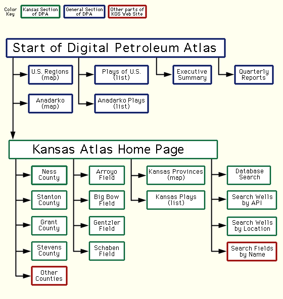
Figure 1.-- Digital Petroleum Atlas--Site Map. Map provides an overview of the Digital Petroleum Atlas structure and can be used to navigate to specific areas of the atlas. Map is a graphical user interface that can link user to specific areas of the DPA. Map is accessible from tool bar at the top of all DPA pages. The direct URL is http://www.kgs.ku.edu/DPA/dpaMap.html.
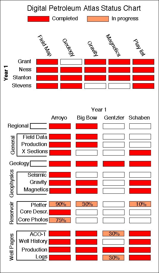
Figure 2.-- Chart showing the status of each of the counties and fields included in the Digital Petroleum Atlas. Chart can be accessed on-line at http://www.kgs.ku.edu/DPA/Reports/statusChart.html
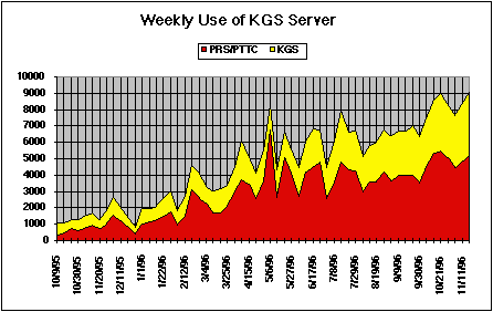
Figure 3.-- Usage of the Petroleum Research Section (PRS) and Kansas Geological Survey web site through the week of 28 October 1996. Updated graph and detailed statistics are available at http://www.kgs.ku.edu/PRS/usage/past_stats.html.