Most of the hydrocarbon production and potential are in Oklahoma, Kansas, the Texas Panhandle, and Arkansas, but the region also includes parts of Nebraska, Missouri, Colorado, Iowa, Minnesota, Wisconsin, and Michigan. Altogether, 74 conventional plays were identified in this region, most of them in the southern Midcontinent where the sedimentary section is thicker and source rocks are better.
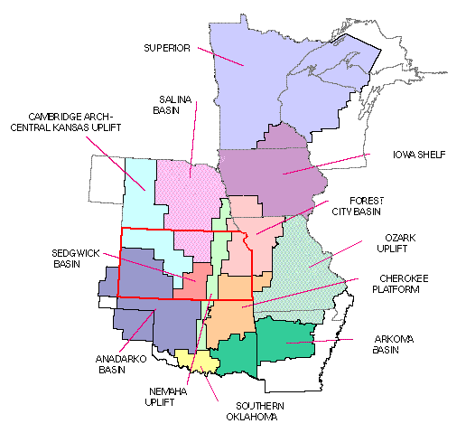
The thickness of the sedimentary cover increases from 0 in the north to over 40,000 ft in the south. In the northern and central parts of the region, remains of a Precambrian rift zone provide the basis for a hypothetical play (Precambrian Midcontinent Rift System). Besides that, there is very little production or potential in the northern part of the region because of very thin sedimentary section and scarcity of mature source rocks.
The central part of the Midcontinent (Kansas, Nebraska, and Missouri) is an area of considerably greater production and potential. The area has undergone repeated periods of gentle warping into broad basins and arches, the most important of these being in Pennsylvanian time. Because of the gentle and episodic nature of these tectonic events, the sedimentary cover is very similar throughout much of the central and southern Midcontinent: carbonates in the late Cambrian and early Ordovician, mixed clastics and carbonates in the rest of the Ordovician, Silurian- Devonian carbonates (of more limited extent), Mississippian carbonates, and Pennsylvanian-Permian clastics. The sedimentary section is generally a few thousand feet thick and hydrocarbon sources, through both local and long-range migration from the south, are good.
In the southern Midcontinent (Oklahoma, Arkansas, and the Texas Panhandle), the sedimentary section is generally similar to that in the central Midcontinent but much thicker, exceeding 30,000 ft in the deep Anadarko and Arkoma Basins. The deep basins rimming the southern edge of the region have a two-stage origin. The southern Oklahoma Aulacogen filled with thick carbonate and clastic sediments of Cambrian through Devonian age. Later, a mid- Pennsylvanian collision event created foredeeps filled primarily with clastics. Source rocks are very good and mature in this area. The southern Midcontinent includes most of the best remaining potential, particularly in the Anadarko and Arkoma Basins.
Many of the plays in the Midcontinent are in a mature stage of exploration. Because of this, a large part of the remaining resources consists of inferred resources in discovered fields and undiscovered resources in smaller fields.

