Kansas Geological Survey, Current Research in Earth Sciences, Bulletin 254, part 1
Prev Page--Introduction and Prior Work || Next Page--Discussion and Conclusions
![]()
![]()
![]()
Kansas Geological Survey, Current Research in Earth Sciences, Bulletin 254, part 1
Prev Page--Introduction and Prior Work ||
Next Page--Discussion and Conclusions
![]()
The lower Williamsburg coal consists of up to 8 cm of bituminous coal overlain by up to 30 cm of carbonaceous shale with abundant plant fossils (fig. 5; Bowsher and Jewett, 1943, p. 52). A striking feature of the unit was several vertical shafts of carbonized wood a meter or more high that represent lycopod trunks buried in growth position (Lanier, 1993, p. 4-8; Archer et al., 1993, p. 1-20–1-22; Archer et al., 1994; apparently destroyed by would-be collectors ca. 1993). Abundant fragmented plant fossils in the carbonaceous shale include Cordaites, Neuropteris, Pecopteris, Calamites, Asterophyllites, Annularia, Sphenophyllum, and Lepidophylloides leaves and Lepidodendron bark (Scott Hageman, in Robb, 1991, p. 50). Spirorbis, a coiled polycheate worm, is attached to leaves of the first three genera. The bivalves Myalina and Aviculopecten are reported from the shale (Robb, 1991, p. 8; Lanier, 1993, p. 4-8); we did not observe these, although myalinids are abundant in the overlying Amazonia Limestone Member (fig. 2). Siderite concretions within the shale have yielded, in addition to well-preserved plant fossils, horseshoe crabs, cockroaches, shrimp, and arachnids (Archer et al., 1993, p. 1-20).
That part of the Lawrence Formation exposed below the lower Williamsburg coal consists of mudstone, "pin-stripe" shales, siltstones, and sandstones and lenticular sandstones. "Pin stripe" as used by Lanier (1993; after Klein, 1977) is taken to mean intimate, repetitive interlamination of millimeter-scale siltstone or fine sandstone within shale or mudstone. [Note: Pinstripe lamination was introduced by Folk (1973, p. 717; "pin-stripe beds" in McBride and Folk, 1979, p. 863) for "remarkable laminae resembling parallel white pencil lines" on chert of the Caballos Novaculite of west Texas. Klein (1977, figs. 42, 43) applied the term to mm-scale sand layers within muddy deposits of modern tidal flats. Kvale and Archer (1990, p. 566) specified that the sandstone layers be discontinuous and equated "pinstripe lamination" with "lenticular bedding" of Reineck and Wunderlich (1968). However, Archer (1993, p. 2-8; Archer and Feldman, 1995, p. 130) later appended "pinstripe bedding" to the familiar diagram of Reineck and Wunderlich (1968) to denote somewhat more continuous and planar beds than their "lenticular" bedding. That figure is reproduced here as fig. 10, with the altered spelling (no hyphen).] Pinstripe lamination is prevalent throughout; lenticular and wavy bedding are common; flaser bedding is confined to a few sandstone-rich units in the upper interval (figs. 7-9).
Immediately below the coal is 20 to 60 cm of light-gray (5Y5/1), clay-rich, blocky mudstone with poorly developed root molds and probable gleying ("underclay" in fig. 5). No unequivocal peds were observed, in contrast to the substrate of the upper Williamsburg coal, some meters higher in the section, which has well-developed small peds. This mudstone grades down into interbedded sandstones, siltstones, and shales with pinstripe bedding and some lenticular or wavy bedding. Individual beds cannot be satisfactorily correlated in the upper meter or two because of poor exposure and the lack of distinctive beds. Deformation structures appear rare in this part of the sequence. Both flaser bedding (West, in Robb, 1991, p. 9; Lanier, 1993, p. 4-8) and "laminations diagnostic of tidal current activity" (Archer and West, 1991, p. 89) are reported from this interval. Bioturbation is minimal, except in a few horizons near the top, noted by Lanier (1993).
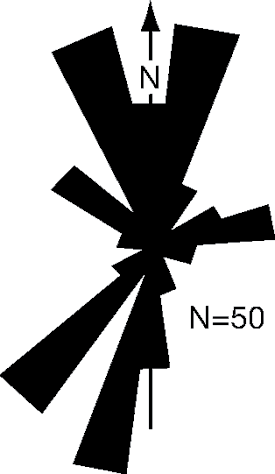
Meter-scale lenticular sandstone bodies occur at several levels within the upper interval, from 1.6 to 5.2 m below the coal. These sandstone lenses crosscut adjacent mudstone and pinstripe shale with generally sharp contacts, producing a concave-up, flat-topped channel form. The thickest channel fills, by far, are 1.4 m (fig. 7, 3-9 m and 8-16 m, fig. 8). [Note: The very muddy fill of the 3-9-m channel (fig. 7) may have undergone considerable compaction. The slight upward bulge of the overlying beds (fig. 7) indicates less compaction than that in the enclosing heterolithic facies, however. Adjacent sand-filled channels (e.g. fig. 7, 8-16 m) commonly show a sag in overlying beds, suggesting incomplete fill.] Most are filled with sandstone with inclined bedding or ripple-cross lamination and internal truncations (fig. 7, 8-16 m). All the sandstone is very fine grained, but thinner bedding and predominance of siltstone toward the tops of channel forms defines fining-upward sequences. Filling of the channel forms was generally asymmetric with gently inclined beds (fig. 8). Opposing current directions were measured from adjacent ripple cross-laminated beds (fig. 9) within the channel-form sandstone at 8-16 m (figs. 7, 8). Additional paleocurrent directions were recorded on measured sections 15, 14, 13, and 9. Lanier (1993, p. 4-7) presented a rose diagram of 50 paleocurrent measurements from throughout the Lawrence Formation at Lone Star spillway. Most of the measurements are apparently from our study interval below the lower Williamsburg coal (Lanier, 1993, p. 4-6 to 4-8), where inclined bedding is prevalent and exposure is much more extensive. The paleocurrents are strongly bimodal, with modes directed N and SSW (fig. 11).
Figure 8--Largest of channel forms within the upper interval of the Lawrence Formation (8-16 m, fig. 7). Thin sandstone beds filling the channel form generally dip gently to the right (north). Intense deformation, mainly ball-and-pillow structures, is visible on both sides of the channel and beneath it. Load casts are present within the lower part of the channel form, especially toward the left margin (arrows).
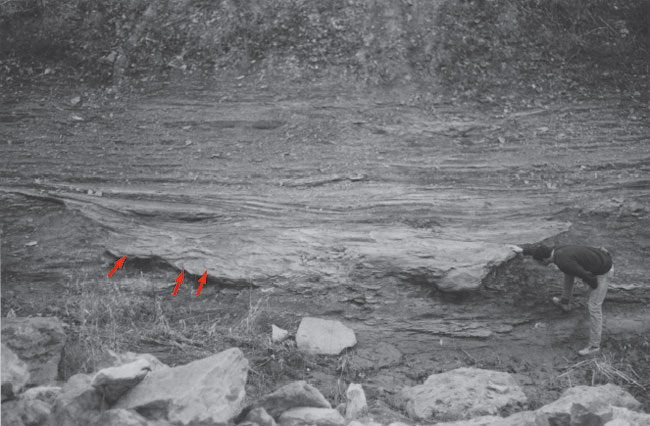
Figure 9--Ripple-drift cross lamination in flaser-bedded sandstone and siltstone at the south (left) margin of the channel form in fig. 8 (9 m, fig. 7). Medium-scale inclined bedding, deeper within channel, dips toward the right (north) at the bottom of the photo. Arrows show approximate paleocurrent directions from ripple lamination; numbers record measured paleocurrent directions. Bimodality is prominent (see fig. 11). Scale (right) is 15 cm long.
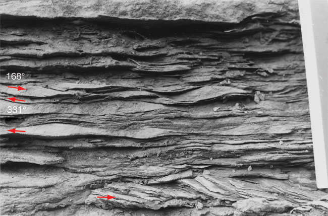
Figure 10--Relationships of flaser, lenticular, wavy, and "pin stripe" bedding. These types of bedding, sometimes referred to as "tidal bedding" (Wunderlich, 1970; Reineck and Singh, 1975, p. 108), are characteristic of, but not restricted to, tidal environments where sedimentation alternates between bed load and suspension load (from Archer and Feldman, 1995, p. 130; modified after Reineck and Wunderlich, 1968).
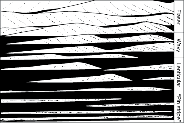
Figure 11--Paleocurrent directions from the upper Lawrence Formation at Lone Star Lake spillway, showing strong bimodality (from Lanier, l993).
Several channel forms are filled almost entirely with mudstone (e.g. fig. 5, sections 9, 10, and 15; fig. 7, 3-9 m and 33-41 m). Any sandstone and siltstone within these channels is confined to ball-and-pillow lenses, presumably the remnants of thin sand or silt layers. Identifying mud-filled channels within the predominate mudstone presents challenges, but truncation, particularly of coarser lithologies, is evident at the margins.
Each channel form is at a unique stratigraphic level. Channel margins overlap or truncate one another in some cases, but none is of exactly the same age as is demonstrated by tracing the thin capping sandstone or siltstone beds from one channel to another. Channel forms are so lenticular, occur in such abundance, and are so lacking of unique features that it is hazardous to attempt to correlate them without continuous exposures, even across the few tens of meters separating the opposite sides of the spillway. Two channel forms were tentatively correlated from the west wall to the east to provide an indication of their trends. The most prominent channel form, near the southern end of the studied exposure (fig. 7, 8-16 m; fig. 8), is elongated in an ESE/WNW direction (120o). The channel form at 32-41 m (fig. 7) is elongated approximately ENE/WSW (fig. 6).
Sediments were extensively deformed at the margins of many channel-form sandstones (figs. 5, 7, 8). Deformation structures associated with channel forms are mostly ball-and-pillow structures or pseudonodules, some up to decimeter scale. These are in contrast to the small load casts scattered throughout the thinner-bedded portions of the outcrop. Convolute lamination is common, generally associated with load casts or pseudondules.
Pinstripe and lenticular bedding are prevalent in the lower interval of study (fig. 5) where channel-form sandstones are absent. Lateral continuity of thin beds is striking, notably the datum couplet, which can be traced throughout the exposure for 195 m (fig. 5, sections 1-10). Bioturbation is minimal. Deformation structures are widely and patchily distributed, but a cluster of load casts and pseudonodules just below the lower datum couplet can be traced through sections 1 to 10 (fig. 5). Most structures are small load casts. A recumbent penecontemporaneous fold with limbs tens of centimeters long extends from section 1 to 3 (fig. 5). Clay diapirs disrupt siltstone beds in sections 3 and 7 (fig. 5).
The dramatic preservation of the carbonized tree trunks within the lower Williamsburg coal at the top of the study interval attests to the rapidity of sediment deposition (Gradzinski and Dokter, 1995) in this unit, buried by tidal rhythmites (Archer, 1993, p. 2-21; Lanier, 1993, p. 4-8). The upper parts of the preserved trunks, more than a meter high, extend well into the pinstripe rhythmites. The thin coal, sandwiched between apparent tidal deposits (see below) and replete with brackish to marine biota (Spirorbis, Myalina, and Aviculopecten) in the upper part, apparently formed in a paralic swamp. Nodules within the upper shaly part of the coal contain an eclectic assemblage of plants and terrestrial and brackish-water arthropods (Archer et al., 1993, p. 1-20), demonstrating a considerable contribution from the low-relief hinterland.
The light-gray clayey mudstone with probable root molds subjacent to the lower Williamsburg coal is interpreted as underclay, representing the leached soil on which a coal-forming swamp developed.
Pinstripe, lenticular, wavy, and flaser bedding of shale, siltstone, and sandstone (fig. 10) that dominate within the studied interval of the Lawrence Formation can form in various depositional settings. However, in combination and abundance, they are very suggestive of tidal processes (Reineck and Wunderlich, 1968; Reineck, and Singh, 1975, p. 108; Archer, 1993, p. 2-8). More definitive evidence of tidal influence comes from analysis of thickness variations in siltstone-mudstone couplets in vertical sequence from the interval immediately overlying the lower Williamsburg coal. The variations show a wave-form repetition of thickening and thinning with a maximum wave length of 14 depositional events, interpreted as representing a lunar hemicycle of diurnal tides with thicker spring-tide and thinner neap-tide deposits (Archer, 1991, 1998). Fluctuations in current strength, in which traction transport in current ripples alternates with suspension sedimentation, results in lenticular, wavy, or flaser bedding (Reineck and Wunderlich, 1968). Lanier (1993, p. 4-9) observed cycles of bedding from pinstripe to lenticular to pinstripe in the Lawrence Formation at the Lone Star spillway, indicating longer-term, repetitive alternation of energy conditions. These he interpreted as neap-spring-neap sequences (Lanier, 1993, p. 4-9). The predominance of pinstripe bedding and the scarcity of flaser bedding presumably result from the predominance of mud over sand and silt, indicating relatively low tidal velocities or disproportionate rates of supply.
Larger, meter-scale sandstone lenses are prominent in the upper sequence (figs. 5, 7, 8). The lenses are interpreted as true channels, rather than slump scars or slide deposits. No slump folding, listric faults, incipient slides, tensional structures, debris beds, or other features indicative of slumps or slides are exposed within the upper sequence. In fact, none has been reported from anywhere within the Lawrence Formation, with the possible exception of the recumbent fold in the lower sequence, discussed below. Extensive deformation within and adjacent to the channels is confined to vertical gravitational deformation resulting from differential loading. Truncation surfaces within the channels are interpreted as internal reactivation surfaces, possibly on a scale of spring-neap cycles, but more likely from channel migration or from superposition of ebb- and flood-dominant channel bars. Detailed correlations based on tracing beds in outcrop indicate that each lens is a discrete channel intersected by the exposure, not segments of meandering channels that weave in and out of the plane of exposure, because each lens occurs at a unique stratigraphic level. The minimal lateral extent of the channels indicates a lack of lateral migration, typical of channels in the middle or upper tidal flats (cf. Weimer et al., 1982). The shallow depth of the channels, judged from thickness of fill, also suggests a position high on the tidal flats, or a microtidal regime (less than 2-m range). Allowing for compaction or incompleteness of fill (see footnote 2) could push the range to mesotidal. Allen Archer (1993, p. 2-28) has argued that low tidal ranges result in low sedimentation rates and, consequently, greater bioturbation. He concludes that "nonbiturbated heterolithic rhythmites [like those at Lone Star], based upon modern analogs, appear to require at least mesotidal conditions."
Bipolar reversing paleocurrent directions (fig. 9) measured within a channel are consistent with the bimodal, bipolar current directions, diagnostic of tidal currents, measured throughout the sequence by Lanier (1993; fig. 11).
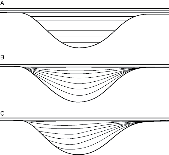
The asymmetrical filling of channels (fig. 8; fig. 7, 3-9 m, 8-16 m, 17-21 m [lower of superposed channels], 34-38 m [lower], 48-57 m, 49-51 m? [ higher]) may be indicative of tidal channels rather than subaerial or subaqueous channels, following McKee (1957) and Reineck and Singh (1975, p. 63). Asymmetrical channel filling (fig. 12) is interpreted as a product of currents that flow diagonally through the channel, as is commonly observed where intertidal flats are under water, and water flow is controlled to a greater extent by differences in water levels than by surface morphology (Reineck and Singh, 1975, p. 63).
Figure 12--Three patterns of channel fill: A) horizontal layers, common in subaerial channels; B) layers conforming approximately to the channel shape, common in subaqueous channels; C) asymmetric fill by inclined layers, common in tidal regimes (from Reineck and Singh, l975, p. 63; based on McKee, l957).
The deformational structures in both the upper and lower intervals appear to have resulted from penecontemporaneous soft-sediment deformation. The structures observed include load casts, pseudonodules, ball-and-pillows, and a recumbent fold (fig. 5). Deformation is confined to a single sandstone-shale couplet, as in load casts, or to a few adjacent couplets in the case of ball-and-pillow structures and pseudonodules (definitions of Owen, 1987, 2003a, b). The overlying sand layers are flat and undeformed, even over the most intensely deformed intervals (figs. 7 and 8). Thus deformation occurred near the surface and was essentially completed before deposition of the next layer, perhaps as soon as the next diurnal or lunar tidal cycle.
These structures typically result from gravitational instability due to a reverse density gradient (Owen, 1987, p. 19; Allen, 2003). In the Lawrence Formation, thin sand or silt layers were deposited rapidly, probably within a single tidal cycle, by ripple migration over water-saturated mud. The sand would have an initial porosity of about 40%; water-saturated mud porosities are typically 70% to 80% (Beard and Weyl, 1973; Enos and Sawatsky, 1981), so the bulk density of mud would be much lower (cf. Pettijohn et al., 1987, p. 113). Cohesiveness of the mud prevents the sand from settling as single grains. Sand and silt layers settle and disintegrate into blebs wrapped in mud that is concomitantly displaced upward. Judging from the scale and internal lamination, many of the blebs nucleate around individual ripples. This indicates that the slight loading differential introduced by the thickness differences between ripple crests and troughs was sufficient to cause deformation. The muds were indeed weak, but cohesive.
The soft-sediment deformation in the upper interval of the sequence occurs primarily around and within the channels. This again suggests that the weight of the sands deposited onto the muddy layers and the resulting inverse density gradient triggered the deformation. Undercutting at channel margins may have contributed, but no coherent slump or tensional structures were observed. The gravity mechanism drives the deformation concurrent with deposition or, at latest, prior to consolidation (Pettijohn et al., 1987, p. 113). Load deformation is particularly striking in many of the mud-filled channels (fig. 7, 3-9 m and 33-41 m). The initial configuration of the fill was apparently mud interlayered with sand and silt, but load deformation has reduced the sand and silt beds to pseudonodules and ball-and-pillow structures.
The origin of a recumbent fold, extending between sections 1 and 3 near the base of the sequence (fig. 5) is more enigmatic. The consistently south-verging axes of this fold and smaller synsedimentary folds (fig. 5, section 1) are testimony of some slope. Such structures can result from creep or slumping on very low slopes. Repeated cyclic loading of the sediment by tidal flooding might induce incipient liquefaction in sand layers or loss of thixotropy in the mud, thereby reducing the slope necessary for lateral motion. [Note: Thixotropy is "the property of certain colloidal substances. . . to weaken or change from a gel to a sol when shaken but to increase in strength upon standing" (Neuendorf et al., 2005, p. 669).] Slopes, even low slopes, are not prominent features of most tidal flats. Slopes of very different scales can be generated by bank erosion along tidal creeks (Reineck and Singh, 1975, p. 90), through depositional relief on sand waves (Dalrymple et al., 1990) or tidal bars (Reineck and Singh, 1975, p. 80), or by draping over preexisting topography. No channel forms are exposed in the lower sequence where the recumbent folds occur. Depositional relief on low-amplitude bar forms is a possibility in the estuarine setting proposed for this part of the Lawrence Formation by Archer and Feldman (1995), but the lateral persistence of very fine bedding within the lower interval at Lone Star spillway argues against depositional relief within the dimensions of the outcrop. Three incised valleys have been identified within the Douglas Group in northeast Kansas below the level exposed at Lone Star spillway (fig. 2; Ireland and Tonganoxie Sandstone Members, Archer et al., 1994, and a smaller, unnamed one within the Vinland Shale Member, Feldman et al., 2005). Drape over the Tonganoxie Sandstone Member paleovalley had probably been compensated by the time of deposition of the very thin and persistent Haskell Limestone Member (Ball, 1985; fig. 3; the apparent relief is determined by the datum chosen and extreme vertical exaggeration). The Ireland Sandstone Member channel (fig. 2) is stratigraphically and geographically closely subjacent to the interval studied, although the Lone Star locality may lie "in the non-valley-part of the depositional system." (Archer et al., 1993, p. 1-8). Compactional topography with very gentle relief nevertheless seems a possibility. The regional lateral discontinuity of units in the upper Lawrence Formation (fig. 3) could in part reflect such relief.
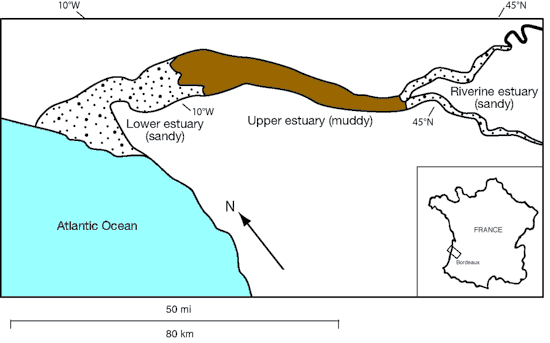
The sedimentary structures and bedding features observed indicate deposition dominated by tidal processes. A plausible interpretation of the depositional environment is a tide-influenced estuarine environment, as proposed by Archer and West (1991), Archer (1993), Lanier (1993), and Archer and Feldman (1995). The high mud content of the section suggests the relative placement of the sequence in the estuary. Different sections of an estuary system produce different lithofacies distribution. In a modern example of the Gironde Estuary of France (fig. 13; Allen, 1991, Archer, 1993; Archer and Feldman, 1995), the upper estuary ("central estuary" in the widely cited terminology of Dalrymple et al., 1992) is the muddiest portion; shale or mudstone would be the dominant resultant rock. In contrast, the riverine estuary and lower estuary (fig. 13; inner and outer estuary, resp., of Dalrymple et al., 1992) are sandier; sandstone with muddy interbeds would be the expected dominant lithology.
Figure 13--Diagrammatic map of the modern Gironde Estuary below Bordeaux, France (from Archer and Feldman, 1995, p. 130; after Allen, 1991). The lower estuary, upper estuary, and riverine estuary mapped here correspond to the outer, central, and inner estuary of Dalrymple et al. (1992).
Relatively rapid and continuous deposition is indicated by the small amount of burrowing throughout the sequence, the preservation of tree trunks above the coal, and the abundant soft-sediment deformation. This suggests an abundant sediment flux during the deposition of the sequence, despite the inferred low energy. Several processes can augment the sediment flux in a low-energy setting. Deposition in the turbidity maximum, formed where suspended sediment is trapped at the upstream limit of the saltwater wedge is one such process (Allen, 1991). The limit of the saltwater wedge is controlled primarily by the river discharge, so it can migrate considerably within an estuary. The central estuary is the realm of convergence of marine processes (tides and waves) and river currents (Dalrymple et al., 1992, p. 1,131) with portions of their respective sediment loads. This convergence coupled with low energy sets the stage for rapid deposition. An obvious condition for rapid sedimentation of mud is a large suspended-to-bed-load ratio in the fluvial system at the head of the estuary. Such ratios are favored by humid climates with deep chemical weathering and by rivers that are deep relative to their width. Feldman et al. (2005) presented evidence that the Ireland Sandstone Member valley fill was deposited in a relatively wet seasonal climate, whereas the upper part of the Lawrence Formation was deposited during the transition to drier seasonal climates in the Oread Limestone. The lower Williamsburg coal and the subjacent gray, gleyed paleosol indicate that depostion of the underlying sequence at Lone Star spillway was still under relatively humid conditions.
Tidal rhythmites are reported immediately above the lower Williamsburg coal (Archer, 1993, p. 2-21–2-23) and implied from the interval below the coal (Archer and West, 1991), but no quantitative measures were provided that could be used to calculate short-term accumulation rates. In general, accumulation rates on tidal flats are among the most rapid of any depositional setting (Kvale and Archer, 1990, p. 572; Enos, 1991, p. 78; Lanier et al. 1993, p. 869; Greb and Archer, 1998, p. 81), at least for very short intervals of days to decades, the time scale particularly relevant to load deformation.
The study interval at Lone Star was divided into an upper and lower interval by the accident of exposure, but also by sedimentary characteristics. Sandstone channels and extensive soft-sediment deformation characterize the upper interval (fig. 5, sections 9-15). Laterally persistent thin siltstone beds within mudstone typify the lower interval (fig. 5, sections 1-7). Both intervals are interpreted as tidal deposits; why are they so different? Channels and increased soft-sediment deformation appear to be cause and effect, respectively, so the incision of channels is the key question. Did current energies increase, perhaps because of increased runoff or breaching of a channel-mouth bar? No change in grain size is noticeable, although the percentage of sand is higher in the upper interval because sand is dominant in the channel fills. Incision might result from a drop in base level, in this case, sea level. Tidal sedimentation continued into the upper interval, however, so any shift would have been within the tidal range, inferred above to be microtidal or mesotidal. Alternatively, a rise in sea level, necessarily less than the tidal range, might have shifted the setting from the uppermost, non-channeled tidal flat, into a lower, channeled regimen. This would be more consistent with the overall transgressive trend. There is little evidence for a choice among these alternatives.
In summary, the Lawrence Formation exposed at Lone Star Lake is interpreted as a tide-influenced, upper (central) estuary, mud-flat sequence dissected by discrete sand- and mud-filled channels. This interpretation is consistent with the conclusions of low-energy, restricted, nearshore deposits suggested by Hakes (1972, 1976) from trace fossils. The lower Williamsburg coal at the top of the study interval was apparently deposited in a brackish-to-freshwater swamp as the estuary filled. Our results support and strengthen conclusions of Lanier (1993) concerning this sequence. Deformation structures throughout the sequence are interpreted as soft-sediment deformation resulting from rapid deposition with inverse density gradients in the original sediment.
Prev Page--Introduction and Prior Work || Next Page--Discussion and Conclusions
Kansas Geological Survey
Placed online July 16, 2008
http://www.kgs.ku.edu/Current/2008/Enos/03_results.html
email:webadmin@kgs.ku.edu