Kansas Geological Survey, Current Research in Earth Sciences, Bulletin 252, part 2
Prev Page--Stratigraphic Characteristics || Next Page--Depositional History
![]()
![]()
![]()
Kansas Geological Survey, Current Research in Earth Sciences, Bulletin 252, part 2
Prev Page--Stratigraphic Characteristics ||
Next Page--Depositional History
![]()
The Kansas Geological Survey proposes that the Tuttle Creek Lake Spillway section, located in northeast Kansas, be considered for the Carboniferous-Permian boundary stratotype in Kansas. It is further suggested that the stratigraphic position of the Carboniferous-Permian boundary in the Tuttle Creek Lake Spillway section be considered as a potential North American stratotype.
The Tuttle Creek Lake Spillway section is located in Pottawatomie County approximately 5 mi (8 km) north of Manhattan, Kansas (fig. 2). The spillway is at the east end of the dam. In 1993, heavy rains created record water levels in the lake. Water was released through the spillway flood gates, resulting in extensive erosion of the spillway area below the spillway apron. Over 100 vertical feet (30 m) of Carboniferous and Permian rocks were exposed as bedding plane surfaces covering several thousand square feet. Weathering and vegetation have somewhat diminished the spectacular nature of the exposures uncovered by the flood, but the spillway area remains an excellent locality to observe the Red Eagle Limestone (fig. 3) and should remain so in the foreseeable future. The spillway is on public property (U.S. Army Corps of Engineers) and is readily accessible.
Figure 2--Portion of the 7 1/2-minute Tuttle Creek Dam quadrangle (Kansas) showing the location of the Tuttle Creek Lake Spillway section of the Red Eagle Limestone. Photograph (looking west) shows the uppermost Johnson Shale and Red Eagle Limestone outcrop at the spillway.
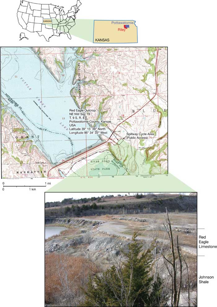
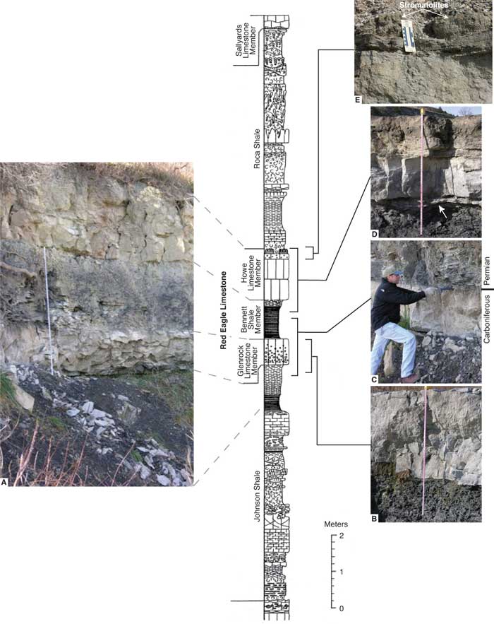
Figure 3--Stratigraphic section (modified from Miller, 1994) and outcrop photographs from the Tuttle Creek Lake Spillway. A) Photograph showing representative outcrop expression of the upper portion of the Johnson Shale, Glenrock limestone, Bennett shale, and Howe limestone. Measuring tape is 6.5 ft (2 m) in length. B) Photograph of the uppermost Johnson Shale and Glenrock limestone. Note sharp contact at the base of the Glenrock limestone. Measuring tape is 4 ft (1.2 m) in length. C) Photograph of the uppermost Johnson Shale, Glenrock limestone, and Bennett shale. Rock hammer is placed at the contact between the Glenrock limestone and Bennett shale, representing the Carboniferous-Permian boundary. The upper Glenrock limestone surface is sharp, irregular (cm-scale relief), and locally shows burrowing and fractures that are filled in with overlying Bennett shale at this locality. D) Photograph of the uppermost portion of the Bennett shale, illustrating the calcareous-rich facies at the top of the Bennett shale (arrow) and a sharp contact with the overlying Howe limestone. Measuring tape is 5 ft (1.5 m) in length. E) Photograph of uppermost portion of the Howe limestone. Locally exposed stromatolites cap the Howe limestone at this locality. Scale in photos is in centimeters and inches. A larger Acrobat PDF version of this figure is available (372 kB).
The Tuttle Creek Lake Spillway section has been extensively studied; several measured sections are available (Miller, 1994; West, 1994; Keairns, 1995; Olszewski, 2000), and numerous publications cite this locality, including several specific to the Carboniferous-Permian boundary (Ritter, 1995; Boardman et al., 1998; Olszewski and Patzkowsky, 2003; Wardlaw, Davydov, et al., 2004; Wardlaw, Boardman, et al., 2004).
All three members of the Red Eagle Limestone-the Glenrock limestone, Bennett shale, and Howe limestone (in ascending order)-are present and readily distinguishable at the Tuttle Creek Lake Spillway section. The lower and upper Red Eagle Limestone contacts with the Johnson Shale and Roca Shale, respectively, are sharp, and paleosols within the Johnson and Roca here have been documented and studied (Miller et al., 1996; Miller and West, 1998; Olszewski and Patzkowsky, 2003).
The bottom 2.5 cm (1 inch) of the Glenrock is a brecciated carbonate mudstone. Most of the Glenrock is a light-gray, intraclastic packstone/grainstone that is sparsely fossiliferous except for the upper 2-3 cm (0.8-1.2 inches), which is a highly fossiliferous packstone/wackestone dominated by fusulinids. The upper surface contains borings and/or burrows filled with black shale from the overlying Bennett Shale Member (Miller, 1994; West, 1994). The basal Bennett shale represents a major flooding event with a possible hardground at the top of the Glenrock limestone (Boardman et al., 1998). Boardman et al. (1998, p. 23) reported Streptognathodus conodonts in the uppermost part of the Glenrock, but it was "unclear as to whether they are from the Glenrock limestone or from the Bennett shale inclusions in the burrow systems." Earlier works (Chernykh and Ritter, 1994; Davydov et al., 1995; Ritter, 1995; Chernykh and Ritter, 1997; Davydov et al., 1998) placed the first occurrence of the "isolated-nodular" form of Streptognathodus (S. isolatus) in the Glenrock limestone, but publications after Boardman et al. (1998) (Wardlaw and Davydov, 2000; Sanderson et al., 2001; Olszewski and Patzkowski, 2003; Wardlaw, Boardman, et al., 2004) place the first appearance of S. isolatus at the base of the Bennett shale.
The Bennett is a black fissile shale that contains orbiculoid brachiopods, fish teeth and bones, and Streptognathodus conodonts (Boardman et al., 1998). The upper 15 cm (6 inches) contains burrows filled with skeletal debris. The base of the Bennett is a marine condensed section based on the significant increase in the number of conodonts in this interval (Boardman et al., 1998). The first appearance of Streptognathodus isolatus has been identified at the base of the Bennett shale at the Tuttle Creek Spillway section (Boardman et al., 1998; Wardlaw, Boardman, et al., 2004).
The Howe is a yellowish-gray fossiliferous wackestone/packstone/grainstone. Fusulinids are most conspicuous in the middle part of the limestone, but the Howe fusulinids have not been described. The top is capped by a skeletal grainstone and columnar stromatolites.
Heald (1916) named the Red Eagle Limestone and designated exposures southwest of Foraker, Osage County, Oklahoma, as the type locality. Unable to locate Heald's original section, Keairns and Boardman (2001) proposed a new principal reference section for the Red Eagle Limestone near Burbank, Osage County, Oklahoma; however, they did not differentiate the members. Condra (1927) named the type localities for the Glenrock Limestone, Bennett Shale, and Howe Limestone Members from exposures in southeast Nebraska.
Outcrops of the Red Eagle Limestone can be traced from southeast Nebraska to north-central Oklahoma (O'Connor and Jewett, 1952; Mudge and Yochelson, 1962; McCrone, 1963) (fig. 4). The Red Eagle pinches out in central Oklahoma (Lincoln County) where a facies change to siliciclastic red beds occurs (Branson, 1964). From outcrop exposures, the Red Eagle dips gently westward into the subsurface where it loses its identity in eastern Colorado in siliciclastic deposits of the Fountain Formation (O'Connor and Jewett, 1952). The thickness of the Red Eagle in Kansas ranges from approximately 10 to 35 ft (3-10.7 m) (O'Connor and Jewett, 1952).
Figure 4--A) Location of cross section and B) cross section showing Red Eagle Limestone correlations from Bennett, Nebraska, to Burbank, Oklahoma (modified from McCrone, 1963). Both a larger version of this figure and an Acrobat PDF version (552 kB) of this figure are available.
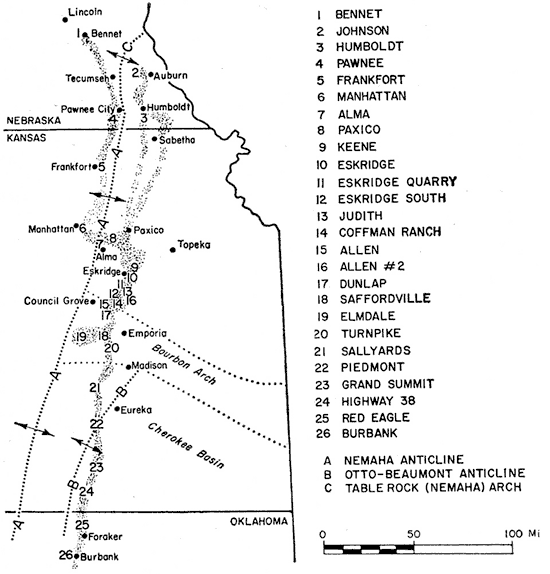
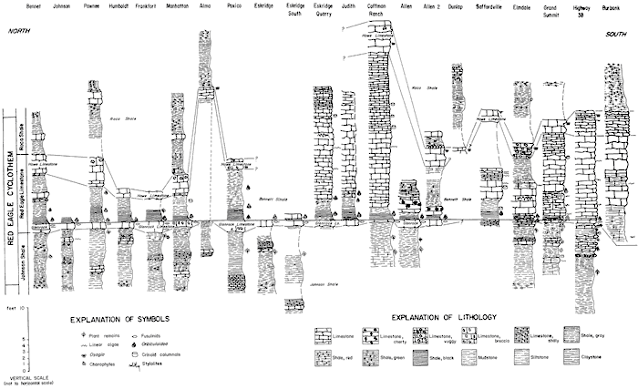
From southwest Greenwood County, Kansas, northward into Nebraska, the Red Eagle Formation is characteristically limestone and gray to black shale in about equal proportions (O'Connor and Jewett, 1952). In southern Kansas and north-central Oklahoma, the Bennett Shale Member changes from shale to predominately limestone. In the limestone facies, shale occurs in one or two thin beds at the base of the interval and as thin partings in the middle or upper part (O'Connor and Jewett, 1952). The basal shales and lower foot or less of limestone in the Bennett shale contain the Orbiculoidea assemblage that is characteristic of this interval. This Orbiculoidea zone is at the base of the Bennett shale and can be traced from Oklahoma to Nebraska (O'Connor and Jewett, 1952).
A cored gas well from the Panoma Gas Area, the Amoco Luke Gas Unit #4 (sec. 8, T. 30 S., R. 39 W.) in extreme western Kansas (Stanton County) (see electric log and core images of the Red Eagle interval between 2,864-2,894 ft at http://abyss.kgs.ku.edu/pls/abyss/qualified.well_page.DisplayWell?f_kid=1006155585) demonstrates how different the Red Eagle Limestone is in this area relative to the sequence in the eastern part of the state. At this western location, the Howe Limestone Member is silty, and the dark-gray, radioactive Bennett shale is a distinct marker underlain by siliciclastics of the Johnson Shale. The Glenrock limestone is absent in this core.
In Kansas, the lithologies of the three Red Eagle members are distinct (except in the subsurface of extreme western Kansas as noted above) and can even be distinguished in the southern part of the outcrop belt where the formation is almost entirely limestone (O'Connor and Jewett, 1952).
Prev Page--Stratigraphic Characteristics || Next Page--Depositional History
Kansas Geological Survey
Web version July 19, 2006
http://www.kgs.ku.edu/Current/2006/sawin/04_type.html
email:webadmin@kgs.ku.edu