Kansas Geological Survey, Current Research in Earth Sciences, Bulletin 252, part 1
Prev Page--Introduction || Next Page--Facies
![]()
![]()
![]()
Kansas Geological Survey, Current Research in Earth Sciences, Bulletin 252, part 1
Prev Page--Introduction ||
Next Page--Facies
![]()
In earliest Mississippian time, the southern margin of North America delineated the northern boundary of a transequatorial seaway connecting the Iapetus and Panthalassic seas (Noble, 1993). The convergence of Laurasia and Gondwana closed off the transequatorial seaway in the Late Carboniferous, forming a series of borderland basins that filled with clastic sediments and were subsequently overlain by Permian carbonates and evaporites (Noble, 1993).
Although most of the major tectonic phases are thought to be much later, Noble (1993) provides evidence indicating that the Ouachita deformation started in the Late Devonian to earliest Mississippian. Evidence for Early-Middle Mississippian tectonism is present in Kansas as well. Goebel (1968) indicated that the eastern flank of the Transcontinental arch in western Kansas should be recognized as having been a positive area in Early Mississippian time. Similarly, Lane and DeKeyser (1980) showed that the Transcontinental arch was a subaerial physiographic element during much of the Paleozoic and that associated subaerial areas along the eastern margin included the Nemaha ridge and Central Kansas uplift (CKU). They also indicate that the Transcontinental arch areas were near base level and intermittently subaerially exposed and submerged during Early-Middle Mississippian time.
The study focuses on Ness County, which is located on the upper shelf of the Hugoton embayment of the Anadarko basin, on the southwest flank of the Central Kansas uplift (CKU), at the western edge of the Mississippian (Osagean) subcrop beneath the sub-Pennsylvanian unconformity (fig. 1A). The CKU is the southeastward extension of the Transcontinental arch (see Goebel, 1968; Lane and DeKeyser, 1980). Several authors indicate that the CKU started to become a structurally positive element before and during Early Mississippian deposition but that the structural movements were minor compared with later tectonic events (e.g. Goebel, 1968; Thomas, 1982; Rogers et al., 1995). Montgomery et al. (1998) and Watney et al. (2001) suggest that features associated with these Early Mississippian events may have influenced depositional patterns.
Figure 1A--Maps showing structural elements (top) and Mississippian subcrop pattern (bottom) for the state of Kansas. Note location of Ness County and Schaben field.
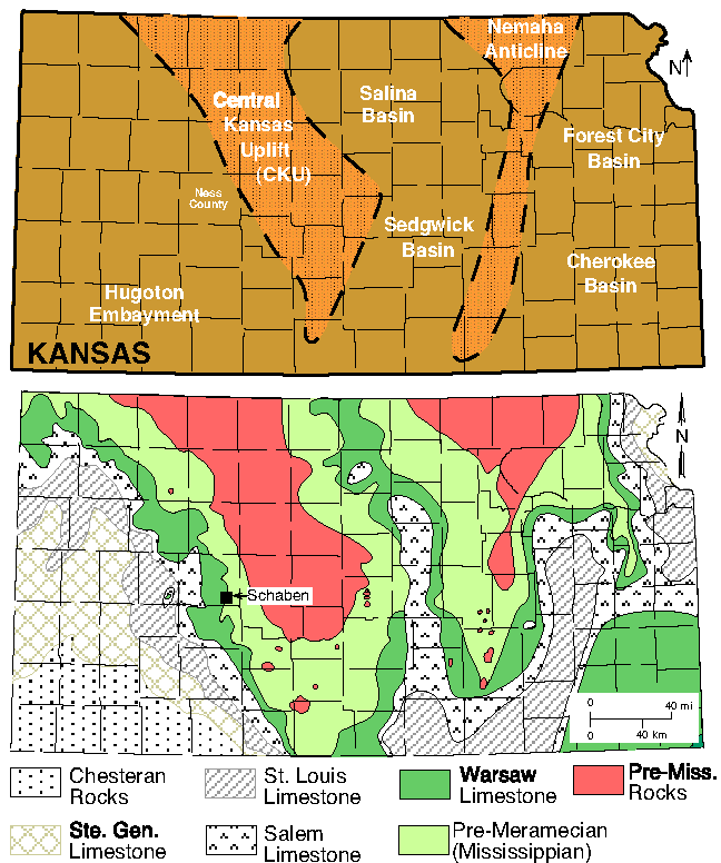
Figure 1B--Mississippian subcrop map of Schaben field area with Kinderhook and Osagean sequences (DS1, DS2) defined in cores and units defined on electric logs (M0-M7). Note locations of three cores that were studied in detail and location of the west to east (A-A') cross section shown in fig. 1C.
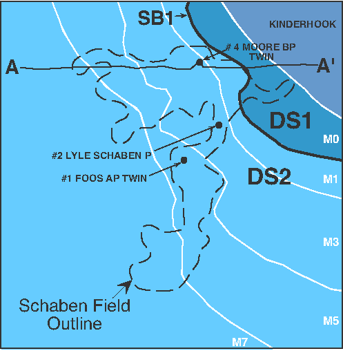
Figure 1C--A-A' cross section with Kinderhook and Osagean stratigraphic units defined in cores and electric logs. These units are unconformably overlain by Pennsylvanian strata. Post-depositional regional uplift, subaerial exposure, and differential erosion of the ramp strata at the post-Mississippian unconformity resulted in paleotopographic highs (buried hills). Logs consist of gamma ray (GR) and suites of resistivity and neutron logs (R, N). A larger version of this figure is available.
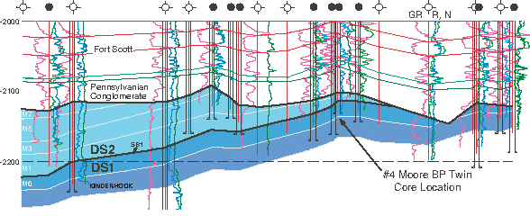
Mississippian rocks are successively younger in a southwestward direction away from the CKU where Mississippian rocks are absent (fig. 1A). This pattern is due mainly to Late Mississippian-Early Pennsylvanian structural uplift related to the Ouachita orogenic event. This resulted in an extensive period of subaerial exposure and erosion of Mississippian strata forming a regionally significant unconformity that separates Mississippian from overlying Pennsylvanian rocks. The inner shelf strata in the study area were differentially eroded at the post-Mississippian unconformity resulting in variable paleotopography (fig. 1C).
Osagean-Meramecian deposition in the region was characterized by shallow shelf carbonates deposited on a gently southward-sloping shelf (ramp). The immediate study area of this paper is in the inner shelf facies (as defined by Lane and DeKeyser, 1980), whereas the shelf edge (bordering the Anadarko basin) is generally mapped several hundred kilometers to the south-southeast, near the Kansas-Oklahoma border (Selk and Ciriaks, 1968; Lane and DeKeyser, 1980; Gutschick and Sandberg, 1983). Generally, shelf facies consist of limestones, dolomite, and cherts whereas basin facies are predominantly argillaceous limestones and shales with minor amounts of chert (Lane and DeKeyser, 1980; Gutschick and Sandberg, 1983). Rogers et al. (1995) emphasized that it is most difficult to identify a shelf margin with significant topographic relief and instead characterize the margin as a facies boundary marking a transition from "shallow" oxygenated waters to "deeper" less oxygen-rich waters (their quotes). Along the shelf margin, irregular or oval sponge bioherms, 15-48 m thick, consisting mostly of sponge spicule-rich mud, developed below wave base (Montgomery et al., 1998). According to Montgomery et al. (1998), fossiliferous burrowed lime wackestone and mudstone was deposited on the inner and middle shelf (Osagean limestone and equivalents), grading into finer-grained carbonate and interbedded shale downdip (Cowley Formation). As shown in this study, inner shelf areas were also sites of shallow-water biosiliceous and heterozoan carbonate (mostly dolomite) accumulations.
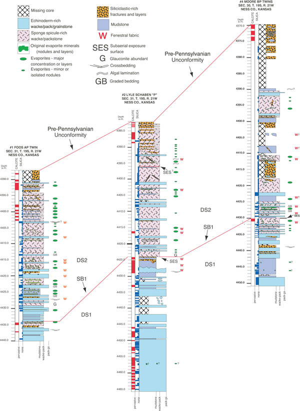
Osagean strata in Kansas comprise a number of formations and members, including the Burlington Limestone, Keokuk Limestone, and undifferentiated Burlington-Keokuk Limestone (fig. 2). This study focuses on cores from the Schaben field area in Ness County (fig. 1). Based on conodont data, Osagean rocks west of the CKU, including those of this study, probably belong to the Keokuk Limestone (Goebel, 1968). The cores are subdivided into two major units, Depositional Sequence 1 (DS1) and Depositional Sequence 2 (DS2) (fig. 3). The two sequences are separated by a regional surface of subaerial exposure that resulted from a relative sea-level fall and forms a sequence boundary (SB 1).
Figure 2--Mississippian stratigraphic units as defined for the state of Kansas. This study focuses on Osagean (Keokuk Limestone) strata. From Maples (1994).
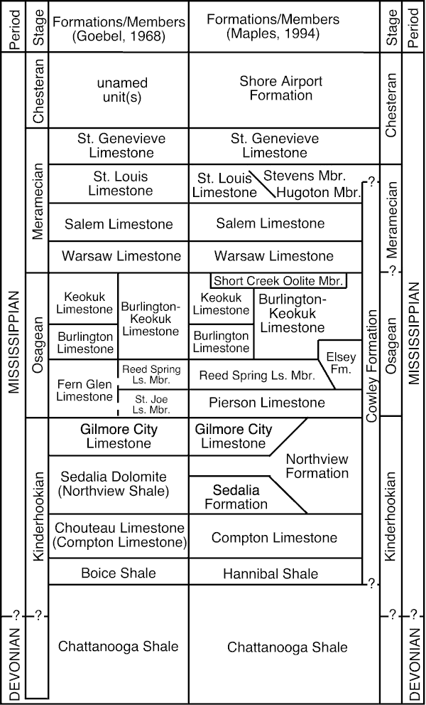
Figure 3--Core descriptions for the three cores from the Schaben field area showing depositional facies (see fig. 1B for locations). Also shown are relative abundance of calcite and silica replacements and cements. SB1 is identified in all cores based on evidence of subaerial exposure and associated calcite replacement and cementation fabrics. This surface is used for correlation and separates DS1 (below) from DS2 (above). This figure is available as an Acrobat PDF version (44kB).
Prev Page--Introduction || Next Page--Facies
Kansas Geological Survey
Web version July 10, 2006
http://www.kgs.ku.edu/Current/2006/franseen/03_geol.html
email:webadmin@kgs.ku.edu