Kansas Geological Survey, Current Research in Earth Sciences, Bulletin 244, part 2
Prev Page--Start || Next Page--Hydrostratigraphic Unit Delineation
![]()
![]()
![]()
Kansas Geological Survey, Current Research in Earth Sciences, Bulletin 244, part 2
Prev Page--Start ||
Next Page--Hydrostratigraphic Unit Delineation
![]()
An essential part of any ground-water investigation is to define and map aquifer and confining units (hydrostratigraphic units) in the subsurface of the study area. Delineation of these units subdivides the geologic framework on the basis of permeability and thus aids in the definition of the flow system. At present, however, there is no widely accepted hydrogeologic code for aquifer and confining-unit nomenclature (Seaber, 1988). The informal designation and delineation of hydrostratigraphic units can lead to confusion, if the process is not based on good scientific evidence and thoroughly documented. Attempts to recognize hydrostratigraphic units as formal entities in the stratigraphic code have met with limited success (P. R. Seaber, personal communication, 1995). Hydrostratigraphic units are considered informal economic units in the 1983 North American Stratigraphic Code (NACSN, 1983).
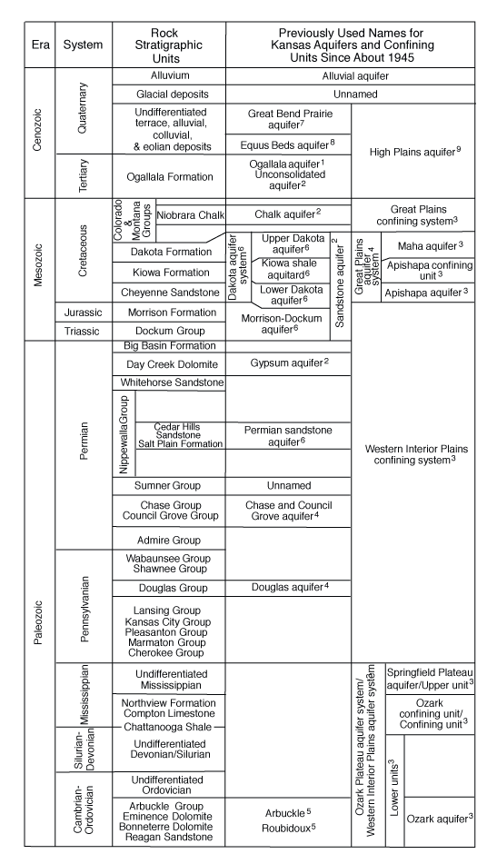
Over the last century, the names of Kansas aquifers have changed as our understanding of ground-water flow systems has improved. Unfortunately, the current assemblage of names for aquifer and confining units in Kansas is a mix of the older and the more recent nomenclature (fig. 1). These names derived from local to multistate regional studies of the Kansas Geological Survey (KGS) and the U.S. Geological Survey (USGS). In the 1980's, multistate hydrogeologic investigations of the water-bearing deposits of the Kansas subsurface were conducted by the Regional Aquifer Systems Analysis (RASA) program of the USGS. In the Central Midwest RASA project, many of the principal aquifers in Kansas were renamed to reflect large-scale hydraulic continuity across state lines, and the major confining unit systems in Kansas were given names for the first time (Jorgensen et al., 1993). However, the less prolific bedrock aquifers in Jurassic through Pennsylvanian rocks were included as part of a more extensive confining unit and were not specifically identified.
Fig. 1--Previously used names for aquifer and confining units in Kansas. Sources: 1 = O'Connor and McClain, 1981; 2 = Gugentag et al., 1981; 3 = Jorgensen et al., 1993; 4 = U.S. Geological Survey, 1985; 5 = Macfarlane and Hathaway, 1987; 6 = Macfarlane, 1993; 7 = Sophocleous, 1998; 8 = Williams and Lohman, 1949; and Gutentag and Weeks, 1980.
In an editorial entitled "Aquifer Names," Jorgensen (1982) argued that the lack of a sound nomenclature fosters misconceptions that may lead to erroneous or unintended hydrologic interpretations. Many of the laws and regulations that pertain to ground water are written by those with no hydrogeological training, who may not recognize the consequences of using a faulty system of nomenclature. In at least one instance in Kansas, State agency regulations designated ground-water sources using the formation names rather than hydrostratigraphic names, which implies that (1) the entire unit acts as an aquifer and (2) there is no hydraulic connection between adjacent permeable units.
The use of stratigraphic names for hydrostratigraphic units is particularly problematic where repeated cycles of alluviation and erosion have resulted in vertically stacked and amalgamated cut-and-fill sequences in the Ogallala Formation and the Quaternary deposits in western Kansas. The resulting complex subsurface stratigraphy is difficult to unravel using the limited information contained in driller's logs. In southwest Kansas, it is extremely difficult to identify the Quaternary-Pliocene unconformity in the subsurface without detailed study of the fossils preserved in these sediments or use of fission-track or other radiometric dating of the sediments (Bayne et al., 1976).
The purpose of this paper is to propose a nomenclature for the aquifer units that are present in the Kansas subsurface using the guidelines proposed by Laney and Davidson (1986). An aquifer is considered to be significant if it yields water to wells at rates equal to or greater than 50 gallons per minute (gpm) or if it supplies water for industry, agriculture, or human consumption.
Prev Page--Start || Next Page--Hydrostratigraphic Unit Delineation
Kansas Geological Survey
Updated February 12, 2002
http://www.kgs.ku.edu/Current/2000/macfarlane/macfarlane2.html
email:webadmin@kgs.ku.edu