Kansas Geological Survey, Current Research in Earth Sciences, Bulletin 240, part 1
Prev Page--Heat-flow Data (con't) || Next Page--References
![]()
![]()
![]()
Kansas Geological Survey, Current Research in Earth Sciences, Bulletin 240, part 1
Prev Page--Heat-flow Data (con't) || Next Page--References
![]()
1. The heat-flow data obtained in this study (table 3, fig. 6) show for the most part that the Dakota aquifer is under fairly normal geothermal conditions similar to other parts of the stable Midcontinent Platform. The heat-flow density in Kansas, as shown on the Geothermal Map of North America (Blackwell and Steele, 1992), ranges mostly from 50 to 60 mW/m2. The values observed in the outcrop area are in the order of 50 to 65 mW/m2. The values are scattered regionally and no general trend is apparent, athough the heat-flow density in the southern part of the aquifer may be slightly lower than in the central and eastern part. To what extent this could be controlled by the water recharge to the system remains to be investigated.
Fig. 6. Location of boreholes discussed in this paper (shown as triangles). Numbers are estimates of heat-flow density. Standard errors are listed with values. Circles represent borehole sites and heat-flow density values measured by different authors (Blackwell and Steele, 1989). Extent of Dakota aquifer also shown.
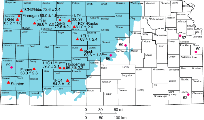
2. Slightly higher heat-flow density values occur in the extreme northwestern corner of the study area, with the highest value of 73.6 ± 2.4 mW/m2 occurring in the 1CN2/Gibs borehole and a relatively high value in the 1GH5 borehole (72.6 ± 2.1 mW/m2). The heat-flow density data reported and mapped for western Colorado and the Nebraska Panhandle region on the western flank of the Chadron Arch also are in this range. Regional differences and inhomogeneties in the heat-flow data of northwestern Kansas are seemingly caused by differences in the make up of the aquifer and variations in the porosity and permeability.
3. Temperature effects linked with the regional water flow out of the Denver Basin are not striking on the shallow basin flank in western Kansas. This also could be evidence for a mingling of different water flows in the area, one source coming from the recharge areas in the south and east with another coming eastward out of the basin. This could be substantiated by thermal, geochemical, and mineralogical analyses in boreholes to be drilled in the area in future.
We thank the GeoForschungsZentrum Potsdam and the Kansas Geological Survey for support of this study. Christoph Grissemann and Günther Koß of the Bundesanstalt für Geowissenschaften und Rohstoffe Hannover (Germany) performed the laboratory measurements of thermal conductivity. We also thank Al Macfarlane, Don Steeples, and Charles Barker, David Blackwell, and John Sass for comments and suggestions on improvement of this paper.
Prev Page--Heat-flow Data (con't) || Next Page--References
Kansas Geological Survey
Web version March 14, 1998
http://www.kgs.ku.edu/Current/1997/forster/forster9.html
email:webadmin@kgs.ku.edu