Kansas Geological Survey, Current Research in Earth Sciences, Bulletin 240, part 1
Prev Page--Methodology of Heat-Flow Determination (con't) || Next Page--Heat-flow Data (con't)
![]()
![]()
![]()
Kansas Geological Survey, Current Research in Earth Sciences, Bulletin 240, part 1
Prev Page--Methodology of Heat-Flow Determination (con't) || Next Page--Heat-flow Data (con't)
![]()
Geothermal gradients were computed for each logging interval and plotted versus depth (figs. 4 and 5). In general, temperature as a function of depth shows a relationship to lithology changes. However, because of the relatively large logging interval, the thin-bedded nature of the sequence (especially in the Carlile Shale and Greenhorn Limestone), and the small thickness (Graneros Shale), it is difficult to generalize the results in terms of formation gradients. Table 3 lists the interval temperature gradients summarized for lithotypes within the stratigraphic groups, the thermal conductivity assigned to each lithotype, and the heat-flow density obtained.
Fig. 4. Temperature-depth and gradient-depth curves. Depth intervals used for estimation of interval gradients (colored boxes) and stratigraphy on group level also are shown.
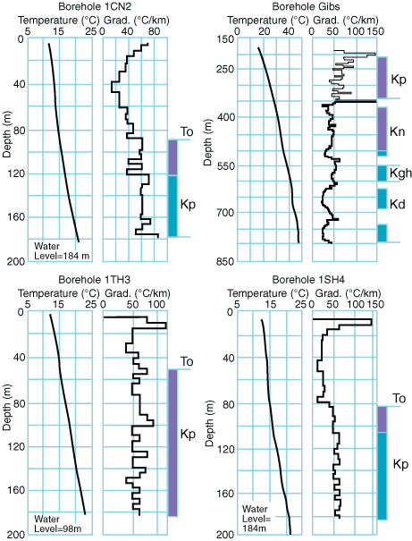
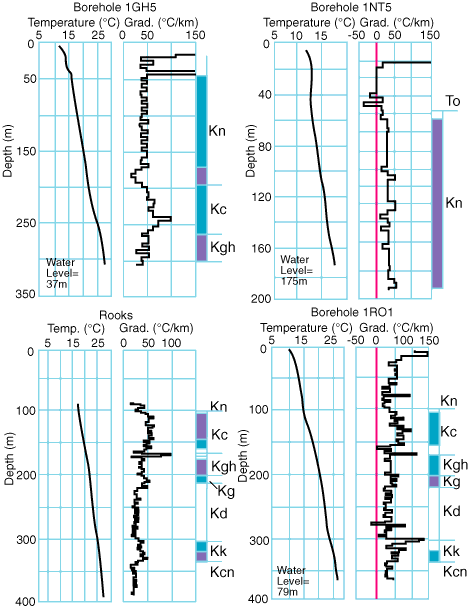
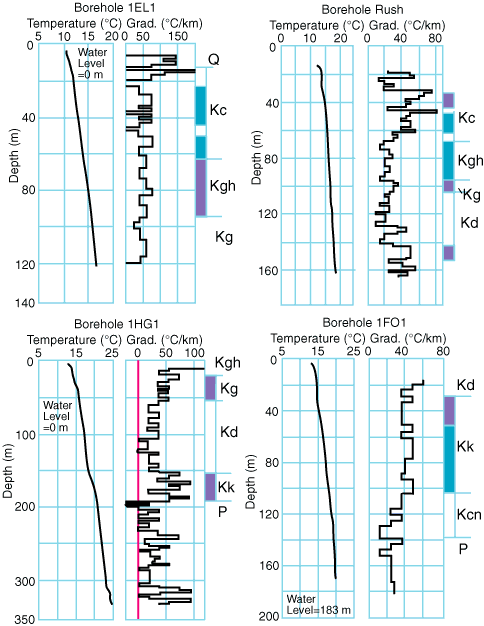
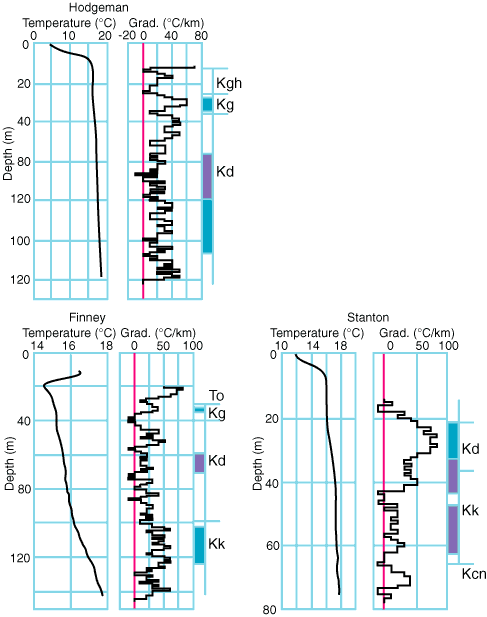
Fig. 5. Temperature-depth and gradient-depth curves for borehole Finegan.
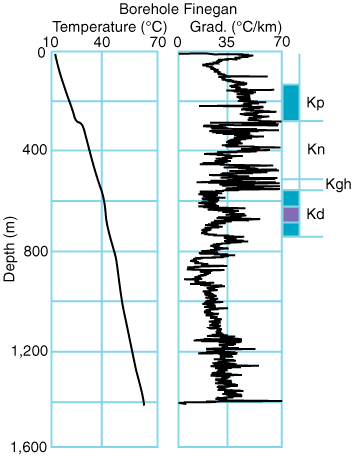
Table 3. Interval temperature gradient, thermal conductivity, and heat-flow density for stratigraphic units. Thermal-conductivity values in parentheses are inferred from heat flow estimated in noncalcareous, marine shales in other depth intervals of borehole sites.
| Unit | Lithology | Temperature gradient (degrees C/km) |
Thermal conductivity (W/mK) |
Heat-flow density (mW/m2) | Borehole |
|---|---|---|---|---|---|
| Pierre Shale (Kp) |
silty shale shale shale shale silty shale shale shale |
53.6 ± 3.3 62.7 ± 2.6 65.8 ± 4.0 56.7 53.2 ± 2.4 55.5 ± 2.4 57.3 ± 3.3 |
(1.4) 1.2 1.2 1.2 1.2 1.2 1.2 |
(75.2) 75.2 ± 1.8 79.0 ± 2.2 68.0 63.8 ± 1.7 66.6 ± 1.7 68.8 ± 2.0 |
1CN2 1CN2 Gibs Finegan 1SH4 1SH4 1TH3 |
| Niobrara Formation (Kn) |
chalky shale limestone chalky shale chalky shale limestone |
43.0 ± 4.4 29.2 ± 1.3 36.8 ± 3.0 42.0 ± 2.4 26.2 ± 2.8 |
(1.75-1.8) (2.6-2.7) (1.8) (1.73) (2.77) |
(75.2-79.0) (75.2-79.0) (66.2) (72.6) (72.6) |
Gibs Gibs 1NT5 1GH5 1GH5 |
| Carlile Shale (Kc) |
shale shale shale shale shale shale chalky shale |
60.5 ± 3.7 59.7 ± 3.8 51.4 ± 2.1 51.0 ± 4.7 54.7 ± 4.3 53.0 ± 2.8 47.1 ± 2.3 |
1.2 1.2 1.2 1.2 1.2 1.2 (1.35) |
72.6 ± 2.1 71.6 ± 2.1 61.7 ± 1.6 61.2 ± 2.4 65.6 ± 2.3 63.6 ± 1.8 (63.6) |
1GH5 1RO1 Rooks 1EL1 1EL1 Rush Rush |
| Greenhorn Limestone (Kgh) |
limestone/shale limestone/shale limestone/shale limestone/shale calcareous shale limestone |
49.7 ± 2.2 39.6 ± 3.0 32.8 ± 2.5 34.3 ± 2.0 48.6 ± 3.5 22.9 ± 2.4 |
(1.45-1.59) (1.83) (1.3) |
(72-79) (72.6) (63.1) |
Gibs 1GH5 1RO1 Rooks 1EL1 Rush |
| Graneros Shale (Kg) |
silty shale silty shale shale shale silty shale silty shale |
45.2 ± 2.9 40.6 ± 2.2 49.7 ± 3.7 45.0 ± 3.6 36.7 ± 2.1 31.3 ± 1.5 |
1.2-1.3 (1.4) 1.2 1.2-1.3 (1.4) |
54.2-58.8 ± 1.9 (58.0) 59.7 ± 2.1 54.0-58.5 ± 2.1 (51.4) |
1RO1 Rooks 1HG1 Hodgeman Finney Rush |
| Dakota Formation (Kd) |
sandstone sandstone sandstone sandy shale siltstone/sandstone shale sandstone sandstone sandstone sandy shale |
23.8 ± 1.6 23.2 ± 2.2 23.5 41.6 21.0 65.5 ± 3.3 35.0 ± 2.2 16.4 ± 2.5 25.0 ± 3.4 49.0 ± 1.4 |
3.1 3.1 3.1 3.1 1.1-1.2 3.6 3.2 |
73.8 ± 2.2 71.9 ± 2.6 72.8 65.1 72.0-78.6 ? 126 ? 52.5 ± 2.8 |
Gibs Gibs Finegan Finegan Finegan Stanton Stanton Finney Hodgeman Rush |
| Kiowa Formation (Kk) |
shale/sandstone siltstone shale sandstone silty shale shale/siltstone silty shale silty shale silty shale |
46.7 ± 2.2 15.3 ± 2.8 49.0 ± 3.5 29.2 ± 1.9 34.5 ± 2.4 58.6 ± 4.4 ? 40.5 ± 2.4 43.0 ± 2.4 41.6 ± 3.5 |
1.2 1.2 1.3 1.3 1.3 |
58.8 ± 2.0 70.3 ? 52.6 ± 1.8 55.9 ± 1.8 54.0 ± 2.1 |
Stanton Stanton 1RO1 Rooks Rooks 1HG1 1FO1 1FO1 Finney |
In general, the noncalcareous, marine shales (Pierre, Carlile, Graneros, and Kiowa), for which a thermal conductivity of 1.2 W/mK was assigned, had different gradients. The gradients range from 53.2 to 65.8°C/km (average 58.5°C/km) in the Pierre Shale, from 51.0 to 60.5°C/km (average 55.5°C/km) in the Carlile Shale, and from 45.0 to 49.7°C/km in the Graneros Shale and Kiowa Formation. Regionally, there is a decrease of temperature gradients to the east. It also is evident that the temperature gradients in the noncalcareous, marine shales are higher than in those shales with a higher silt content-for example, in the Graneros Shale (range of 36.7 to 45.2°C/km, average 40.8°C/km) and in the Kiowa Formation (range of 34.5 to 43.0°C/km, average 39.9°C/km). In comparison, the gradients in the calcareous or chalky shales of the Niobrara Formation have an average value of 40.6°C/km, nearly equal to the average gradient of 41.0°C/km in the alternating beds of limestone, shale, and calcareous shale of the Greenhorn Limestone.
Prev Page--Methodology of Heat-Flow Determination (con't) || Next Page--Heat-flow Data (con't)
Kansas Geological Survey
Web version March 14, 1998
http://www.kgs.ku.edu/Current/1997/forster/forster7.html
email:webadmin@kgs.ku.edu