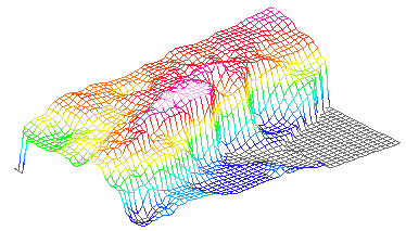
However, the greatest effect on the appearance of a block diagram is produced by the auxiliary commands that control the perspective effect. These establish the viewing position, which is the apparent location of the observer with respect to the surface. Usually a block diagram is drawn as it would appear if seen from a satellite above and to the side of the surface.
The Azimuth command controls the direction of view, measured in angular degrees counterclockwise from the first row of the grid matrix. If the orientation of the grid matrix corresponds to the cartographic convention that north is to the top of the map, this is equivalent to measuring the angle of view from the south.
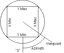
The Distance command defines the distance between the viewpoint and the center of the block. The perspective effect, caused by convergence of receding lines, is more pronounced for short distances. If the viewing distance is very large, lines on the block do not converge and the perspective appearance is lost.
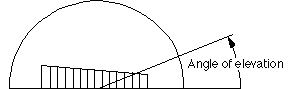
The Elevation command defines the angle of the viewpoint above the horizon. The higher the angle, the more subdued is the impression of relief of the surface.
 go back