Ancient Life in Kansas Rocks, part 2 of 27
Geologists estimate the age of the earth to be at least 4.5 billion years, and in this time many things have happened. Mountains have been raised and eroded, then raised again. Seas have advanced over the land; layers of sand, mud, and calcium carbonate have been deposited on the sea floors, and the waters have retreated, leaving strata of rock thousands of feet thick. Volcanoes have erupted, just as they are doing in many places today, and lava fields have formed. Volcanic dust or "ash" has settled to the earth, sometimes in lakes or ponds, burying whatever lay beneath. Great glaciers, formed during long cold periods, at times have covered a large part of North America, but have melted back with the coming of a warmer climate.
All these events have taken place during the geologic history of the earth. Just as human history is divided into major segments, like the Stone Age and Bronze Age, the 4.5 billion years of earth history have been divided into large units of time called eras. Eras have been divided into smaller units called periods and these in turn have been divided into epochs.
The layers of rock beneath the earth's surface also are compartmentalized into convenient segments. A formation is the fundamental rock unit used in mapping, and consists of an essentially uniform rock type that can be distinguished from adjacent, underlying or overlying rock units at sight. Two or more formations that are in some way related, such as in origin or location, may be called groups.
Mere dividing and subdividing are not enough. Each of the eras and periods, and the rock formations made during these parts of geologic time, must be given a name so that one person can recognize any unit referred to by another person.

The names of the eras seem long and complicated, but each one describes the life that existed during its span. The oldest or first eras (Archeozoic and Proterozoic) are sometimes called Cryptozoic, meaning obscure or hidden life, and very few fossils are found in these rocks. Archeo- means ancient, and protero- means before, or former. The Cryptozoic is also called the Precambrian. The succeeding eras, in order of their age, are the Paleozoic Era (early life), the Mesozoic Era (middle life), and the Cenozoic Era (recent life).
Periods have been named in a different way and, unfortunately, the method used has not been consistent. Some were named from large geographic features; for example, the name Pennsylvanian was chosen for one of the periods because many rocks of that age are found in Pennsylvania. The word Cretaceous, on the other hand, means chalk-bearing, because rocks of the Cretaceous age in many places are made of chalk.
Formations are always named from some geographical feature--a town, a river, a mountain--in the region where the particular rock units are well exposed. Thus the Wellington Formation, deposited during the Permian Period of the Paleozoic Era, was so named because it is well exposed in the region around Wellington, Kansas.
Some of the eras were much longer than others, and the periods, likewise, were not of equal length. The shortest period, the Quaternary, began one or two million years ago, and the longest lasted about 80 million years. The geologic timetable, or column, lists the eras and periods with the typical rocks of each as found in Kansas; the estimated length of each period is also included.
In general it can be said that the oldest rocks, which were deposited first, lie below the younger rocks that were laid down later. Consequently, on geologic timetables it is customary to put the oldest rocks at the bottom and the youngest rocks at the top.
From this timetable it is evident that Kansas has had a long and varied history. Much of the early history is known only from subsurface data, that is, information learned by studying the samples collected during the drilling of wells. This is true of all periods up to the Mississippian, the oldest period with rocks exposed at the surface, in the southeast corner of Kansas. Subsurface samples have shown that during the early Paleozoic, Kansas was undergoing alternate depression and elevation of land. When the land was lowered the sea advanced, but when the land was raised the sea retreated and erosion set in. These conditions lasted through the Mississippian Period.
During the Pennsylvanian Period, the land was flat and near the sea level. The deposits of the period are unusual in that they show a regular alternation of marine deposits (limestones and shales) with nonmarine deposits (shales, sandstones, and coals). There are many fossils in the deposits, and some of the limestones consist almost entirely of the shells of sea animals. Pennsylvanian coal deposits are common. The coal was formed from the remains of plants (fig. 1) that lived in swamps; these plant remains were buried by later deposits as the sea came over the region, and were converted into coal during compaction of the sediment. This coal has been mined throughout eastern Kansas, from small pits near Topeka to large, open-pit strip mines near Pittsburg. Good exposures of Pennsylvanian rocks showing alternations of shale and limestone exist in many places in eastern Kansas.
The early part of the next period, the Permian, was very much like the Pennsylvanian, although during most of this time the sea covered the region, and little coal was formed. Sometime during the Permian, however, the sea water began to change in composition. Because sea water contains large quantities of dissolved salts such as calcium carbonate, calcium sulfate, and sodium chloride in solution, a residue of salts is left behind when the sea water evaporates. The Permian sea in Kansas apparently became partly separated from the main body of the ocean, and the water in this sea left layers of sodium chloride (which we call simply salt) and calcium sulfate (gypsum and anhydrite) many feet thick. There must have been a supply of water coming into this inland sea from the ocean in order to provide enough salt to form deposits so thick. These thick salt deposits are mined in central Kansas, notably near Hutchinson. At times the sea was drained, and the sand and silt were deposited over the salt, gypsum, and shale; these interesting Permian deposits include the red beds of south-central Kansas. The sand and silt were washed down from the distant mountains and deposited along the shores of the retreating Permian sea. The red beds have some gypsum, salt, and dolomite interbedded with them.
Following the Permian Period, there was a long interval of non-deposition and erosion in Kansas. There may be some Triassic rocks in Morton County, but the age of these has not been definitely determined. Jurassic rocks are present in the subsurface of the western part of the state.
The next rocks laid down in Kansas are those of Cretaceous age. The sea again came over the region, this time leaving a succession of sands, muds, and chalks, alternating with coastal stream, swamp, and beach deposits. The well-known chalk of Kansas is of Late Cretaceous age. Another famous Cretaceous deposit of Kansas and adjoining states is the Dakota Formation, which is frequently called a sandstone because the most prominent beds--those that cap the hills and stand out as cliff formers--are sandstones. These sandstone layers are the source of water in many wells in the central and western part of the state. About 80 percent of the Dakota Formation, however, consists of clays of many colors. Also, the formation contains beds of lignite, which, though not a high-grade fuel, was used by the early pioneers for heating their homes and for other purposes.
Exceptionally good fossil specimens found in the upper Cretaceous beds have made Kansas rocks world-famous among the fossil experts. These fossils include fishes (fig. 21), batlike flying reptiles, the sea serpents called mosasaurs, and toothed swimming birds.
After the close of Cretaceous time, the surface of Kansas was uplifted and subjected to prolonged erosion. The Rocky Mountains were formed by deformation of the earth's crust that occurred at intervals from late in Cretaceous time until well into Tertiary time. The deposits next younger than Cretaceous that are found in Kansas are the late Tertiary sands and gravels of the Ogallala Formation. The Rocky Mountains were being worn down by the action of water and wind, and the sands and gravels were carried eastward by the rivers, which, being overloaded with sediment, dropped their excess sand and gravel along the river valleys. Gradually the valleys were filled with these sediments, and finally the hills themselves were covered. In some places there were lakes in which freshwater limestones were deposited. Before deposition stopped, a broad, gently sloping plain had been formed. The existing remnants of this plain extend from Colorado east through Dakota southward into Texas. Today this entire area is called the High Plains.
When deposition of sand and gravel in what is now the High Plains area stopped, there was a long period of stability, followed by another interval of erosion before the glaciers of the Ice Age or Pleistocene Epoch invaded Kansas in the Quaternary Period. The glaciers advanced and receded at least four principal times. Only the northeastern part of Kansas was covered by glaciers. Consequently, the rocks carried by the glaciers and dropped as the ice melted are found only in that part of the state. On the outskirts of this glaciated area are many river gravels containing pebbles and boulders washed out of the glacier by the streams of water from the melting ice. The many rust-colored or pink boulders seen in the northeastern part of the state were carried here from north of Kansas by the glaciers, and left when the ice receded. A windblown dust called loess was deposited around the edges of the glacier area, on the High Plains surface and in the valleys of western Kansas far from the ice sheet. River gravels and dust from later ice advances that did not extend as far south as Kansas were deposited both on top of the glacial boulder clay and on the earlier loess.
Many geologists class the time in which we are now living as part of the Pleistocene Epoch because the climate and nature of sedimentary deposits closely resemble those that prevailed between advances of the glaciers; the time since the melting of the last ice sheet from the northern part of the United States is probably less than 25,000 years. It is a period marked by conditions as we know them today, including the erosion or deposition of sands and gravels along river valleys, the formation of sand dunes, and also of dust or loess deposits by wind action. During this time in Kansas there has been more erosion of the land surface than deposition, as the main geologic forces that are active today in this region are those which are wearing away the older rocks.
The geologic history of Kansas, then, is largely an alternation of more or less prolonged times of sedimentary deposition and times of erosion during which various volumes of previously formed rocks were destroyed. What effect did this succession of geologic events have on the surface of Kansas as we know it today?
The rock layers are not perfectly flat-lying, but have been tilted slightly and eroded, so that some of the older rocks can be seen at the surface. The accompanying geologic map of Kansas and the cross section from the western to the eastern border of Kansas show how the gentle deformation has caused rocks of different ages to crop out in different parts of the state. The older rocks, those of Cretaceous age and earlier, have been tilted and the younger rocks have been eroded or worn from above them. Now the Cretaceous and older rocks are exposed in areas that have the form of broad strips with irregular margins. The older rocks (Mississippian and Pennsylvanian) occur in the eastern quarter of Kansas; the rocks of Permian age--next younger than Pennsylvanian--crop out in a north-south belt across central Kansas, and the Cretaceous and Tertiary rocks are found farther west. The indentations made by valleys that have been cut into the rocks make the pattern of the outcrops irregular. In the northeastern corner of the state, evidence of the southern limit of the glaciers may be seen. Most of the Pleistocene deposits are not shown on the map or cross section because they are so widespread, forming a thin cover over most of the older rocks. If they were indicated, very little else would show.
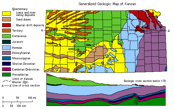
The map indicates the age of the rocks in each county. If you live in the western part of the state, you will be nearest to the rocks and fossils described as occurring in the Tertiary and Upper Cretaceous deposits. If you live in the eastern part, the rocks of Pennsylvanian age will be nearest to you. If the central part of the state is your home, then you can expect to find rocks and fossils of Permian and Cretaceous age nearby.
Man has been in Kansas only a few thousand years, and yet he already has an understanding of the 4.5 billion year history of the state, an appreciation of the origin of the many types of rocks, and the ability to make use of the many fossils to interpret the geologic history of the state. Anyone who has the interest and the time can gain a knowledge of the state's fossils and rocks.
Kansas Geological Survey
Placed online Feb. 1997
URL = "http://www.kgs.ku.edu/Publications/ancient/rep02.html"
Send comments and/or suggestions to webadmin@kgs.ku.edu