


Kansas Geological Survey, Open-file Report 2017-4
Testimony--Rolfe Mandel, Kansas Geological Survey, to House Water and Environment Committee on HB2272, 9 February 2017
by Rolfe Mandel
KGS Open File Report 2017-4
The document is also available as an Adobe Acrobat PDF file, 37 kb.
Mr. Chairman, members of the Committee, thank you for the opportunity to appear before you in regards to HB2272. I am Rolfe Mandel, interim director of the Kansas Geological Survey, University of Kansas. The Kansas Geological Survey is a research and service division of KU, and is charged by statute with studying and reporting information about the state's geologic resources, which includes water. The KGS has no regulatory authority and does not take positions on natural resource issues, including this bill.
However, I do endorse concepts embedded within the bill, of collaboration between water researchers, water agencies and stakeholders to identify water priorities, and the data and studies necessary to address them. Water data, analysis and models inform policy makers, managers, and water users. It provides a strong basis for decision makers to evaluate options and add confidence to their decisions.
The Kansas Geological Survey provides support on several levels:
Basic Data:
- Annual groundwater measurements on 1,400 groundwater wells over the High Plains aquifer.
- Continuous measurement of groundwater levels in 16 index wells.
- Online data available through the KGS website includes individual well location, date and details of construction, annual water use and type of use. Data get imported from the State Agencies that have the responsibility to collect it.
- Water quality data on select aquifers, rivers and contamination sites.
- KGS contains the Data Access & Support Center (DASC). DASC serves as the State's geospatial data clearinghouse, and provides Geographic Information System (GIS) data on water, energy and environmental resources.
Transparency and Accessibility:
- The State water data, KGS reports and KGS models are publically available online. Additionally, KGS researchers frequently give talks to groups and provide help assessing data.
Support for decision makers: The breadth and depth of Kansas' data on the High Plains aquifer allows for evaluations not otherwise possible. For example:
- KGS groundwater models in the GMDs has been used by KSU ag economists to project potential economic impacts of various water management programs.
- Evaluation of the effectiveness of water conservation programs.
- The 2015 study that applied a capital asset value to groundwater in Kansas and estimated wealth reduced with groundwater withdrawals.
An appendix is provided that itemizes many of our current studies that directly support program and management decisions.
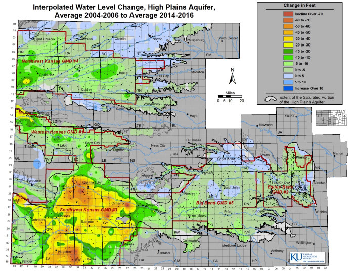
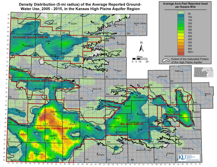
Lastly, I'd like to note the maps and charts attached. We were asked to provide the committee information that illustrates High Plains aquifer water use to water levels. The first map shows the water level change over the past 10 years, and the second map shows the density of water use for the same period. As might be expected, the larger declines are where the greater withdrawals occur. The Groundwater Management Districts are shown on the maps.
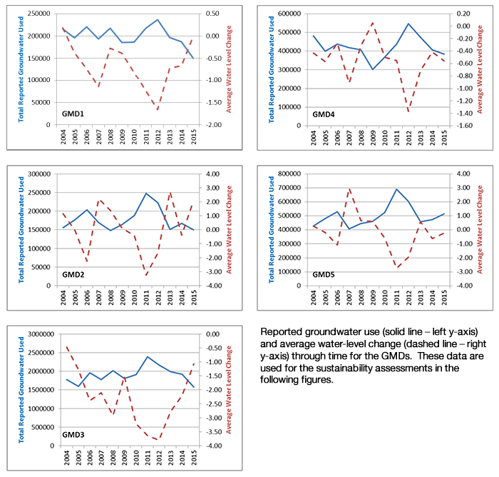
The next page illustrates water level use with average water level change within each Groundwater Management District. The variation in annual water use is primarily driven by the weather; crops require more irrigation in hot dry seasons than cool, wet seasons.
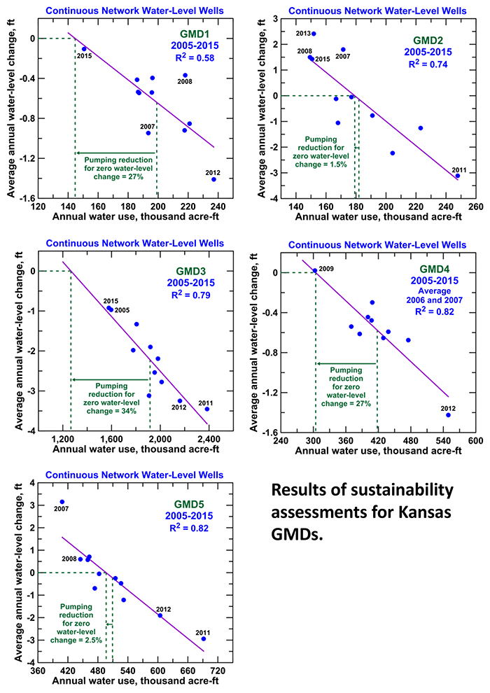
The last page illustrates the relationship between water use and water level change. Applying the best-fit line, the KGS researchers identified the water use reduction needed in each groundwater management district to achieve roughly stable groundwater levels, allowing for annual fluctuations.
Reference
Fenichhel, Eli P., and others, 2015, Measuring the value of groundwater and other forms of natural capital: Proceedings of the National Academy of Sciences, v. 113, no. 9, p. 2382-2387
Appendix
Current and Potential Impact of Kansas Geological Survey's Research and Data on Kansas Water Resource Policy, Management, and Planning
Ogallala-High Plains Aquifer Assessment
- Water-level data and analysis, including index well program--used by groundwater management districts (GMDs), state agencies, financial institutions, and stakeholders in assessment of groundwater resources and future management of aquifer
- Sustainability analysis--used by GMD4 for Sheridan Local Enhanced Management Area (LEMA) and by other GMDs and potential Water Conservation Areas (WCAs) for present or future management; also has shown aquifer inflow to be greater than expected, which has led to more positive approach to what pumping reductions can achieve
- Groundwater modeling--used by GMDs and state agencies to assess effects of future scenarios for management and planning
Kansas River Alluvial Aquifer Assessment (proposed program)
- Water-level data and analysis, including index well program--potential use by water users and local and state agencies in assessment of impacts of current pumping on groundwater levels and Kansas River flows
- Groundwater model--potential use by water users and local and state agencies for examining future development and management scenarios for the aquifer and the corresponding effects of the scenarios on groundwater levels and Kansas River flows
Groundwater-Surface Water Modeling in the Lower Republican River Basin
- Modeling of groundwater and surface water interactions--used by irrigation districts, US Bureau of Reclamation, and state agencies for current management and future planning of water use in the basin
Groundwater Assessment for Missouri River Regional Planning Area
- Evaluation of groundwater information--will be used by Missouri Regional Advisory Committee of the Kansas Water Authority and local and state agencies for future groundwater planning and management
Arkansas River Water Quality Assessment in Southwest Kansas
- Assessment of Arkansas River salinity and uranium concentration--used by GMD3 for potential water management and Kansas Department of Health and Environment for development of plans for water-quality management and improvement
- Assessment of impact of Arkansas River water entering Kansas on water quality of Ogallala-High Plains aquifer and uranium in irrigated crops and soils--current and potential use by GMD3 and local and state agencies in management and planning of saline river water
Aquifer Site Characterization
- Development of new field and analysis procedures and technologies for site characterization of aquifers--used by companies, industry, and state agencies for improving the assessment of contamination movement and the development of appropriate remediation methods
- Development of new procedure for aquifer storage using direct-push technology--potential use by local and state agencies for developing new methods and locations for groundwater storage and recovery
Groundwater Contamination Analysis
- Identification of point and nonpoint sources of contamination such as salinity and nitrate--used by local, state, and federal agencies, companies, and stakeholders for determining methods for water-quality remediation, mana
Kansas Geological Survey
Placed online Feb. 13, 2017
Comments to webadmin@kgs.ku.edu
The URL for this page is http://www.kgs.ku.edu/Publications/OFR/2017/OFR17_4/index.html