Kansas Geological Survey, Open-file Report 2014-3
KGS Open File Report 2014-3
Report to the Calvert Corporation
March 2011
The Kansas Geological Survey (KGS) was contacted by Mr. Dean F. Kruse of the Calvert Corporation in October of 2010 about a possible role for the KGS in helping address exploration issues associated with the Calvert volcanic ash mine located in Norton County, Kansas. On February 23, 2011, KGS scientists Drs. Greg Ludvigson and Jon Smith met with Mr. Kruse and toured the Calvert ash mine site and vicinity. The following report was assembled based on our direct observations of the current site conditions and on previous published research on the Calvert ash deposits and Ogallala Formation strata in Norton County, Kansas.
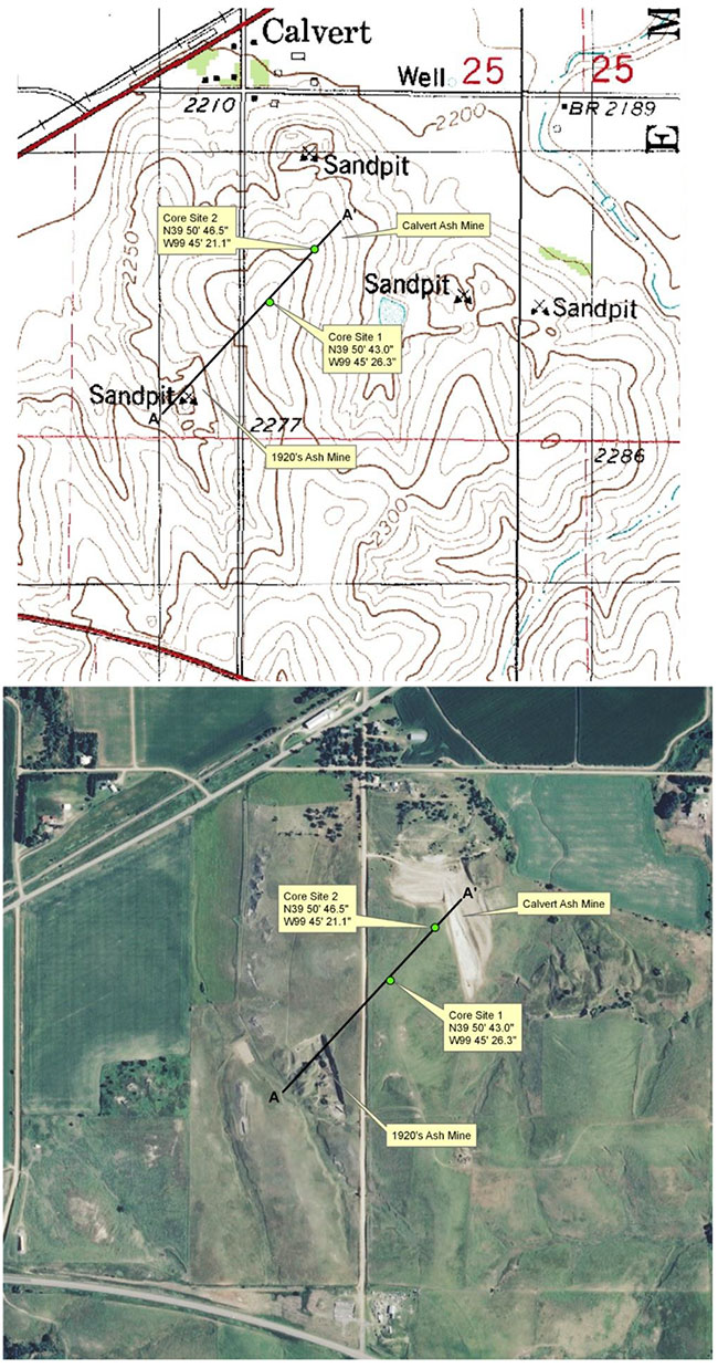
Active mining of volcanic ash began to the south of the town of Calvert in 1908 and one or more ash mines have been in operation in the area almost continuously since that time (Frye and Leonard, 1949). Currently, one large mine is operated at Calvert in the NW SW sec. 25, T. 2 S., R. 22 W. by the Calvert Corporation. The ash is mined by the open-pit method, screened in the pit, and hauled by truck to the storage building located along the rail line in Calvert. An abandoned ash mine is located southwest of the active mine at SE SE sec. 26, T. 2 S., R. 22 W (Fig. 1).
Figure 1--Topographic map and aerial photograph of study area south of Calvert, Kansas showing location of two proposed core sites and trend of cross section A-A' in Figure 2.
The Calvert mine is considered the type locality of a widespread and lenticular bed of volcanic ash that can be correlated in a number of localities in Norton and Phillips counties (Swineford and Frye, 1946). Lenses of ash up to 6 m thick have been excavated from the Calvert mine in the past (Carey et al., 1952), though, during the KGS site visit, the currently exposed layer in the active pit face appeared to range from <1.0-1.5 m thick. The commercial quality ash in the Calvert mine is a very dark, almost metallic shade of gray and is reportedly unaltered by weathering and largely free of contaminants of silt and sand (Carey et al., 1952). Concentrations of calcium carbonate, mostly as invertebrate trace fossils and rhizoliths, are distributed throughout the deposit. Potter (1991) reported a fission-track date from the Calvert Mine Ash Bed of 11.5±0.48 Ma. If the Middle-Upper Miocene age is accurate, the Calvert ash would have likely been derived from the Bruneau-Jarbidge Volcanic Field (12.7-10.5 Ma) of the Neogene Snake River volcanic province in southern Idaho (Ludvigson et al., 2010).
There is an estimated 20 meters of overburden overlying the ash deposit at its thickest point west to southwest of the current mine face (Fig. 2). The overburden consists primarily of interbedded medium-grained and silty sand and fine- to medium-grained calcareous sand. Several m-scale calcrete lenses are present at the top of the section and visible along the north-south trending county road west of the Calvert mine site. The optimum site for a long, continuous core to sample the stratigraphy of the Ogallala Formation at the site would be at the point where the overburden is thickest (Fig. 1, Core Site 1). This location is easily accessible from an access road to the south. A second core site nearer the edge of the mine face would be useful for designing a geophysical technique that could improve definition of the thickness and depth of the volcanic ash layer, and also is indicated on Figure 1.
Figure 2--Idealized cross section of study area south of Calvert, Kansas, based on site visit observations and stratigraphic sections measured along Prairie Dog Creek south of Almena, Kansas by Frye and Leonard (1949).
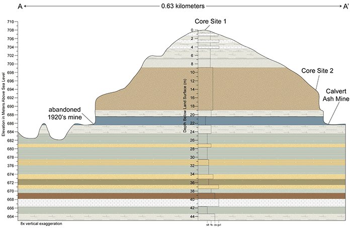
Complementing a core designed to go through the maximum thickness of overburden above the ash deposit would be an electrical resistivity survey (ERS) (Xia et al 2010). Considering the electrical properties of the overburden, as previously identified and the very- high, electrically resistive nature of this clean ash deposit, it is very likely an ERS would allow both the top and bottom of the ash layer to be mapped with reasonable fidelity. Preliminary estimates suggest bed resolution on the order of a meter will be possible at this site. An ERS would provide a reasonable estimate of continuity of the ash layer between the two mined outcrops.
Carey, J. S., Frye, J. C., Plummer, N. and Swineford, A., 1952, Kansas Volcanic Ash Resources. Kansas Geological Survey, Bulletin 96, Part 1, 1-68. [available online]
Frye, J. C., and Leonard, A. R., 1949, Geology and Ground-water Resources of Norton County and Northwestern Phillips County, Kansas. Kansas Geological Survey, Bulletin 81, 1-144. [available online]
Ludvigson, G. A., Sawin, R. S., Franseen, E. K., Watney, W. L., West, R. R., and Smith, J. J., 2010, A Review of the Stratigraphy of the Ogallala Formation and Revision of Neogene ("Tertiary") Nomenclature in Kansas: Kansas Geological Survey, Current Research in Earth Sciences, Bulletin 256, Part 2, 1-9. [available online]
Potter, S. L., 1991, Geologic characteristics of the Calvert ash bed, Ogallala Group (Miocene), western Kansas: M.S. thesis, Fort Hays State University, Hays, Kansas; American Geological Institute, GeoRef Accession No. 1994-056771.
Swineford, A., and Frye, J. C., 1946, Petrographic Comparison of Pliocene and Pleistocene Volcanic Ash from Western Kansas. Kansas Geological Survey, Bulletin 64, Part 1, 1-32. [available online]
Xia, J., Ludvigson, G., Miller, R.D., Mayer, L., and Haj, A., 2010, Feasibility of delineating a volcanic ash body using electrical resistivity profiling: Journal of Geophysics and Engineering, 7, 267-276.
To read this report, you will need the Acrobat PDF Reader, available free from Adobe.
Kansas Geological Survey
Placed online May 21, 2014
Comments to webadmin@kgs.ku.edu
The URL for this page is http://www.kgs.ku.edu/Publications/OFR/2014/OFR14_3/index.html