Kansas Geological Survey, Open-file Report 2008-10
by Robert S. Sawin
KGS Open-file Report 2008-10
This report also available as an Acrobat PDF file (7 MB).
Trenches that were excavated in the Ranch House area for construction of the new water system have provided general information about the underlying bedrock and may offer explanations to ongoing problems, questions, and concerns about water infiltration and stability of the Ranch House structure. Examination of the bedrock by the Kansas Geological Survey during construction on November 25, 2003, was performed in conjunction with field work to develop a geologic map for the Ranch House and Fox Creek School areas. The information contained herein should be used for general purposes only, or as a guide for developing a plan for geotechnical testing if site-specific information is needed.
Elevations on the bedrock units, and their relative position to the Ranch House structure, are tied to a bench mark at the northwest corner of the Ice House (elevation 1313.32 feet) that was established for construction purposes. These elevations also agree with the contours shown in the map (Figure 1) that was taken from the Water Improvements plan. Elevations on the bedrock, the ground floor of the house, the porch, and ties to the bench mark were determined with a hand level (accuracy about + or - 0.2 foot).
Figure 1. Map of the Ranch House area from the Water Improvements plan showing the location of Cross Section A-A'.
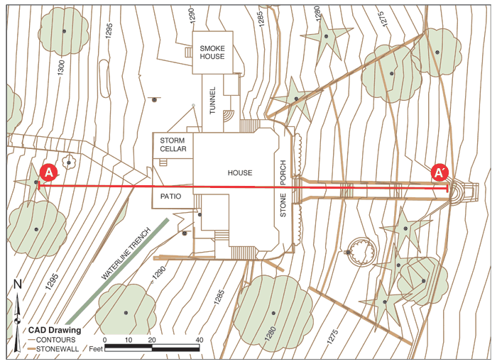
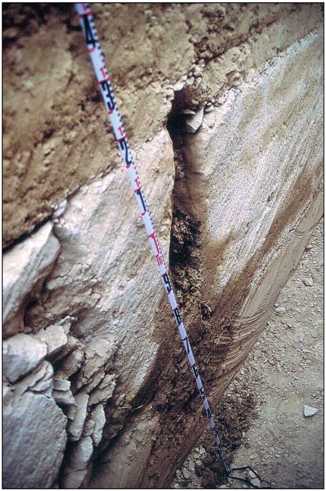
Figure 2 (Cross Section A-A') depicts the west-east cross sectional view through the Ranch House and hillside. The upper limestone shown on the cross section (lower Crouse Limestone) was observed in the waterline trench southwest of the Ranch House (Figure 3). The thickness of the limestone is about 2.4 feet in this trench. Regularly spaced vertical joints (fractures) have been widened by the flow of ground water and are easily seen in Figure 4. Figure 5 is a close-up of one of these enlarged joints. Water was observed dripping from this joint about four hours after the trench was excavated.
Figure 2. Cross Section A-A'.
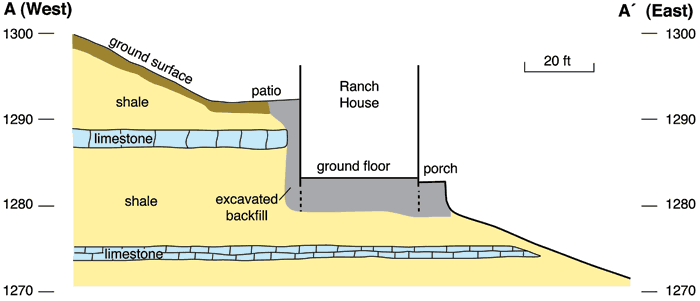
Figure 3. Limestone layer (2.4 feet thick) in waterline trench southwest of Ranch House. This is the upper limestone in Cross Section A-A'.
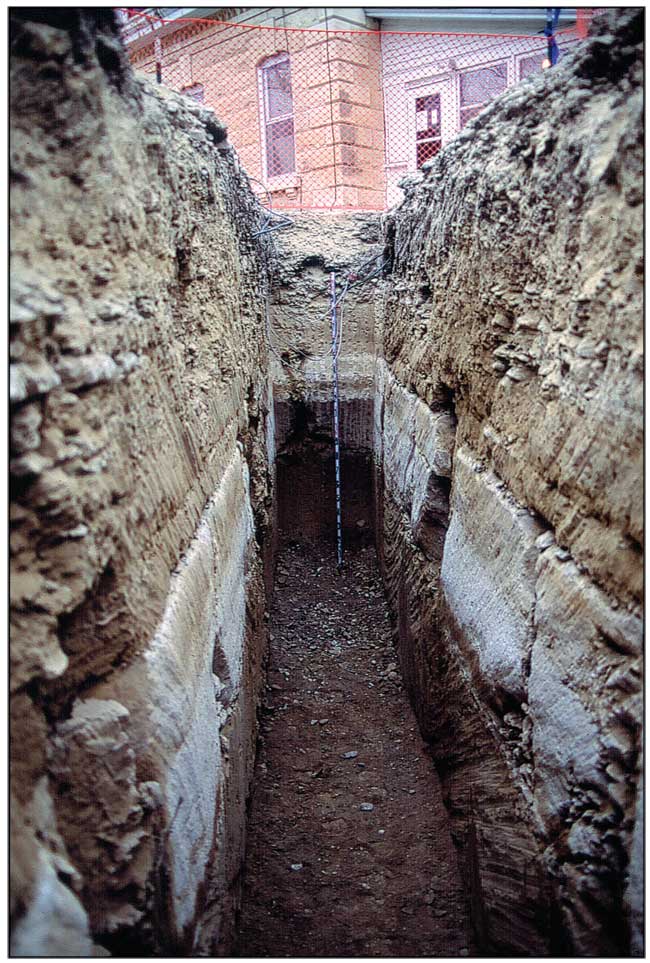
Figure 4. View of the east side of trench. Note the regularly spaced vertical joints in the limestone.
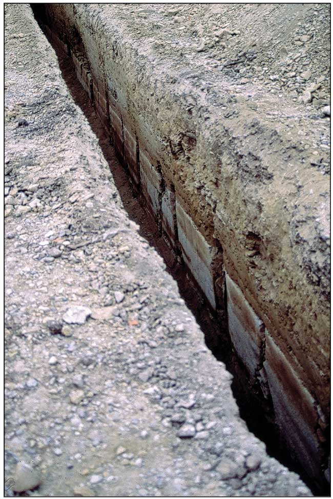
Figure 5. Close-up of a vertical joint. This joint was dripping water about four hours after the trench was excavated.
The lower limestone shown in Figure 2 (limestone in the Easly Creek Shale) was observed in the waterline trench that was dug in the driveway west of the main entrance to the top of the hill. The thickness of this limestone is about 1.4 feet at this location.
Alternating layers of shale and limestone that are characteristic of this area provide conditions for the subsurface movement of water. The fractures (joints) in the limestones contain water at various times, depending on the season and precipitation. These fractures are widened through time by flowing water. The underlying shales are relatively impermeable and therefore stop the downward movement of water, and the limestones serve as conduits to move the water laterally. Where these water-bearing limestones intersect the hillside, they can form springs or seeps.
At the Ranch House, the upper limestone shown in Figure 2 is probably a water-bearing unit during times of abundant precipitation. Where this limestone intersects the Ranch House foundation excavation, it probably transports water to the excavation's backfill material. This might explain reports of running water in the crawl space under the ground floor, and temporary seeps or springs that occur around the front porch.
Examination of the crawl space below the ground floor revealed no bedrock that was in place. Slabs of limestone that are mortared together make up the foundation and floor supports. While the total depth of the foundation was not observed, it probably does not extend to the lower limestone shown in Figure 2. This suggests the Ranch House foundation probably rests on shale bedrock. Further investigation would be necessary to confirm this conclusion.
Kansas Geological Survey, Geology
Placed online Oct. 3, 2008
Comments to webadmin@kgs.ku.edu
The URL for this page is http://www.kgs.ku.edu/Publications/OFR/2008/OFR08_10/index.html