Kansas Geological Survey, Open-file Report 2005-2
by
Rolfe D. Mandel
Kansas Geological Survey
KGS Open File Report 2005-2
This report contains the results of the geoarchaeological investigation conducted in support of the archaeological survey of the proposed expansion of the El Dorado wastewater treatment plant. The primary objectives of this investigation were to (1) determine whether buried archaeological deposits are likely to be preserved in the project area, and (2) test selected localities for buried archaeological deposits by looking for evidence, such as artifacts and cultural features, in backhoe trenches.
The project area is on the valley floor of the Walnut River. Two geomorphic surfaces compose the valley floor in this area: the modern floodplain (T-0) and a broad alluvial terrace (T-1). A gently sloping 2 m-high scarp separates T-1 from T-0. The T-0 surface is confined to the inside of a large meander loop of the Walnut River, and the T-1 surface spans the rest of the valley floor.
Prior to the early 1980s, most archaeologists working in Kansas and other areas of the Great Plains relied on traditional methods of surface surveys to locate prehistoric cultural deposits. These methods, such as pedestrian surveys and shallow shovel testing, rarely detect buried cultural materials. Bettis and Littke (1987: 3) pointed out that inadequate subsurface sampling in stream valleys led to significant gaps in the record of known prehistoric cultural resources, as well as erroneous conclusions about some aspects of regional cultural history. A number of studies (e.g, Artz 1983, 1985; Mandel 1992, 1994a, 1994b, 1995) demonstrated that stream valleys have extensive surfaces that are geologically quite young, often post-dating 2000 B.P., and that most of the existing record of prehistoric cultures is deeply buried. They emphasized the need for understanding the age and soil stratigraphy of landform sediment assemblages in order to adequately evaluate stream valleys for archaeological resources. Hence, this study involved subsurface exploration as a component of the archaeological survey.
The field investigation initially involved reconnaissance of the project area. Based on the results of the reconnaissance, two localities within the project area were targeted for subsurface archaeological testing: the broad, flat tread of the T-1 terrace that will be affected by the construction of the proposed wastewater treatment plant and one set of sewage lagoons (Archaeological Analytic Unit 1), and the area within the meander loop that will be affected by wetland restoration (Archaeological Analytic Unit 3).
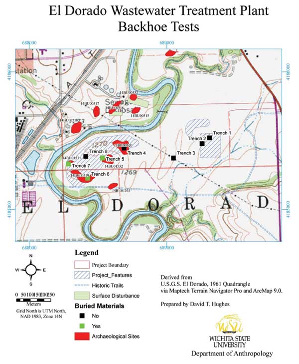
The next phase of the field investigation involved deep testing with a tractor-mounted backhoe. Eight trenches were excavated in the project area (Figure 1). Trenches 1 through 5 were excavated to depths ranging between 2.35 and 3.00 m. Trench walls were cleaned with a trowel, examined for cultural materials, and described. Sediments and soils exposed in these trenches were described using standard procedures and terminology outlined by Soil Survey Staff (1992) and Birkeland (1999). In addition to the five geomorphic trenches, three trenches (trenches 6-8 in Figure 1) were excavated within the meander loop in order to determine the presence/absence of buried cultural materials, but these archaeological trenches were not described.
Figure 1. Map of the project area showing the locations of archeological sites and backhoe trenches.
Alluvial deposits dating to the Holocene and terminal Pleistocene are preserved beneath geomorphic surfaces in the Walnut River valley (see Mandel 1994a). Information about the relative age of these deposits, combined with soil-stratigraphic data, was used to predict where buried archeological materials may occur in the landscape.
The determination of geologic potentials for buried cultural deposits is partially based on the soil record. Buried soils represent previous land surfaces that were stable long enough to develop recognizable soil profile characteristics (Mandel and Bettis 2001). As Hoyer (1980) pointed out, if one assumes that the probability of human use of a particular landscape position was equal for each year, it follows that the surfaces which remained exposed for the longest time would represent those with the highest probability for containing cultural materials. Because buried soils represent these surfaces, evidence for occupation would most likely be associated with them (Mandel and Bettis 2001). It is important to note, however, that buried cultural deposits, even rich ones, also may be found in sediment that has not been modified by soil development (Hoyer 1980). Hence the presence/absence of buried soils cannot be used as the sole criterion for evaluating the potentials for buried cultural materials. The mere presence of Holocene deposits beneath a geomorphic surface offers some potential for buried cultural materials.
Trench 1 was excavated to a depth of 235 cm on the tread of the T-1 terrace in Archaeological Analytic Unit 1 (Figure 1). This trench exposed fine-grained overbank (flood) deposits that have been strongly modified by soil development. The surface soil is a Mollisol with a thick, well-expressed A-BA-Bt-BC profile (Figure 2 and Table 1). The soil has a relatively high clay content (silty clay and silty clay loam) that probably is a product of fine-grained sediment deposited in a low-energy floodplain environment (now a terrace) distal to the channel. However, there also is evidence of pedogenic clay translocation in the form of clay films to a depth of 190 cm.
Figure 2. Photograph of the north wall of Trench 1.
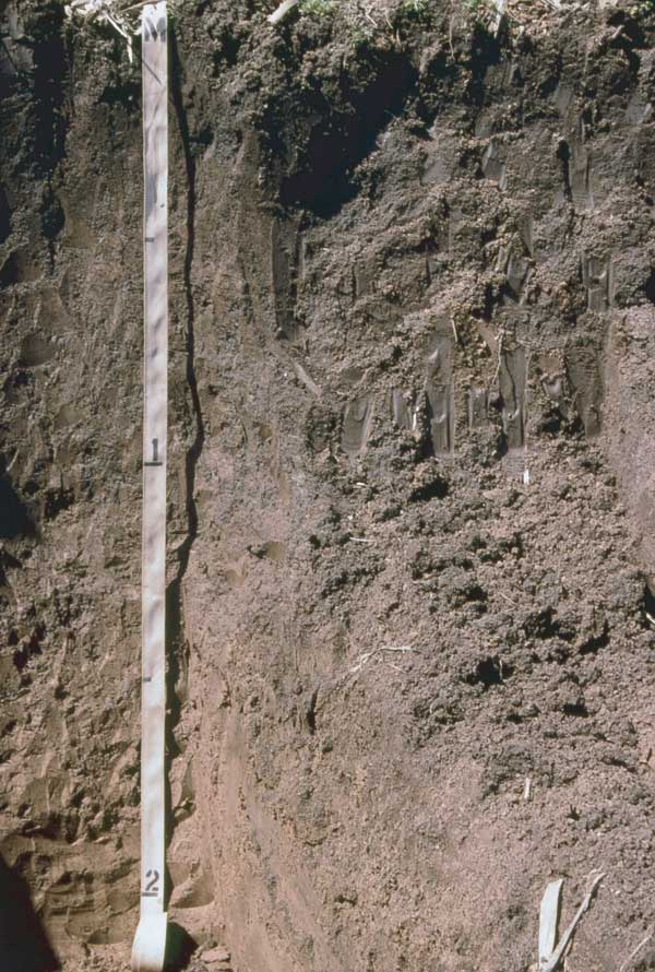
Table 1. Description of the soil profile in Trench 1.
|
Landform: T-1 terrace Landscape Position: terrace tread Parent material: Alluvium Slope: 1% Land cover: Corn stubble |
||
| Depth (cm) | Soil Horizon | Description |
|---|---|---|
| 0-20 | Ap | Dark grayish brown (10YR 4/2) light silty clay loam, very dark grayish brown (10YR 3/2) moist; weak fine granular structure; friable; few common fine and very fine roots; abrupt wavy boundary. |
| 20-42 | A | Dark grayish brown (10YR 4/2) light silty clay loam, very dark grayish brown (10YR 3/2) moist; weak fine granular structure; friable; many fine and very fine roots; gradual smooth boundary. |
| 42-56 | BA | Dark grayish brown (10YR 4/2) silty clay loam, very dark grayish brown (10YR 3/2) moist; weak fine subangular blocky structure parting to moderate fine and medium granular structure; friable; common fine and very fine roots; gradual smooth boundary. |
| 56-107 | Bt1 | Yellowish brown (10YR 5/4) silty clay, dark yellowish brown (10YR 4/4) moist; moderate medium prismatic structure parting to moderate fine subangular blocky; very hard, very firm; many distinct continuous dark grayish brown (10YR 4/2) clay films on ped faces; few fine and very fine roots; gradual smooth boundary. |
| 107-148 | Bt2 | Yellowish brown (10YR 5/4) silty clay, dark yellowish brown (10YR 4/4) moist; few fine faint yellowish brown (10YR 5/6) mottles; moderate medium prismatic structure parting to moderate fine subangular blocky; very hard, very firm; common distinct continuous dark grayish brown (10YR 4/2) clay films on ped faces; few very fine soft iron and manganese oxide concretions; few fine and very fine roots; common fine and very fine pores; gradual smooth boundary. |
| 148-190 | Bt3 | Yellowish brown (10YR 5/4) silty clay loam, dark yellowish brown (10YR 4/4) moist; common fine faint yellowish brown (10YR 5/6) mottles; weak medium prismatic structure parting to weak fine subangular blocky; hard, firm; few faint discontinuous dark grayish brown (10YR 4/2) clay films on ped faces and in pores; common very fine and fine soft iron and manganese oxide concretions; few fine and very fine roots; many fine and very fine pores; gradual smooth boundary. |
| 190-235+ | BC | Yellowish brown (10YR 5/4) light silty clay loam, dark yellowish brown (10YR 4/4) moist; common fine distinct yellowish brown (10YR 5/6) and strong brown (7.5YR 5/6) mottles; very weak medium prismatic structure parting to very weak fine subangular blocky; hard, firm; common very fine and fine soft and few hard iron and manganese oxide concretions; many fine and very fine pores. |
The numerical age of the T-1 fill exposed in Trench 1 is unknown. Based on the magnitude of surface-soil development, the T-1 surface probably has been stable for at least 2000 years. Similar moderately oxidized deposits beneath the T-1 surface in the lower Walnut River valley aggraded soon before 2700 14C yr B.P. (see Mandel 1994a).
There is low geologic potential for buried cultural materials in the area of Trench 1. There are no buried soils in the upper 235 cm of the T-1 fill at this locality, and there is relatively poor drainage because of the high clay content of the surface soil. The walls and floor of Trench 1 were cleaned with a trowel and inspected for artifacts and features, but none were found.
Trench 2 in Archaeological Analytic Unit 1 (Figure 1) provided an opportunity to examine T-1 fill to a depth of 250 cm. Like Trench 1, Trench 2 exposed a surface soil with a thick, well-expressed A-BA-Bt-BC profile (Figure 3 and Table 2) and no evidence of buried soils. Hence, the geologic potential for buried cultural deposits is considered low at the Trench 2 locality. No artifacts or cultural features were recorded in the walls and floor of Trench 2.
Figure 3. Photograph of the north wall of Trench 2.
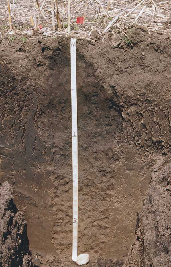
Table 2. Description of the soil profile in Trench 2.
| Landform: T-1 terrace Landscape Position: terrace tread Parent material: Alluvium Slope: 1% Land cover: Corn stubble |
||
| Depth (cm) | Soil Horizon | Description |
|---|---|---|
| 0-20 | Ap | Dark grayish brown (10YR 4/2) light silty clay loam, very dark grayish brown (10YR 3/2) moist; weak fine granular structure; friable; few common fine and very fine roots; abrupt wavy boundary. |
| 20-39 | A | Dark grayish brown (10YR 4/2) light silty clay loam, very dark grayish brown (10YR 3/2) moist; weak fine granular structure; friable; many fine and very fine roots; gradual smooth boundary. |
| 39-55 | BA | Dark grayish brown (10YR 4/2) silty clay loam, very dark grayish brown (10YR 3/2) moist; weak fine subangular blocky structure parting to moderate fine and medium granular structure; friable; common fine and very fine roots; gradual smooth boundary. |
| 55-120 | Bt1 | Yellowish brown (10YR 5/4) silty clay, dark yellowish brown (10YR 4/4) moist; moderate medium prismatic structure parting to moderate fine subangular blocky; very hard, very firm; many distinct continuous dark grayish brown (10YR 4/2) clay films on ped faces; few fine and very fine roots; gradual smooth boundary. |
| 120-155 | Bt2 | Yellowish brown (10YR 5/4) silty clay, dark yellowish brown (10YR 4/4) moist; few fine faint yellowish brown (10YR 5/6) mottles; moderate medium prismatic structure parting to moderate fine subangular blocky; very hard, very firm; common distinct continuous dark grayish brown (10YR 4/2) clay films on ped faces; few very fine soft iron and manganese oxide concretions; few fine and very fine roots; common fine and very fine pores; gradual smooth boundary. |
| 155-210 | Bt3 | Yellowish brown (10YR 5/4) silty clay loam, dark yellowish brown (10YR 4/4) moist; common fine faint yellowish brown (10YR 5/6) mottles; weak medium prismatic structure parting to weak fine subangular blocky; hard, firm; few faint discontinuous dark grayish brown (10YR 4/2) clay films on ped faces and in pores; common very fine and fine soft iron and manganese oxide concretions; few fine and very fine roots; many fine and very fine pores; gradual smooth boundary. |
| 210-250+ | BC | Yellowish brown (10YR 5/4) light silty clay loam, dark yellowish brown (10YR 4/4) moist; common fine distinct yellowish brown (10YR 5/6) and strong brown (7.5YR 5/6) mottles; very weak medium prismatic structure parting to very weak fine subangular blocky; hard, firm; common very fine and fine soft and few hard iron and manganese oxide concretions; many fine and very fine pores. |
Trench 3 was excavated to a depth of 300 cm in an area of the T-1 terrace between Archaeological Analytic Units 1 and 3 (Figure 1). The trench was emplaced on a slightly elevated ridge representing a natural levee on the T-1 terrace. The surface soil is a Mollisol with a thick, well-expressed A-BA-Bt-BC-CB profile (Figure 4 and Table 3). Given the absence of buried soils and the relatively poor drainage at this locality, it has low geologic potential for yielding buried cultural deposits. The walls and floor of Trench 3 were cleaned with a trowel and inspected for artifacts and features, but none were found.
Figure 4. Photograph of the north wall of Trench 3.
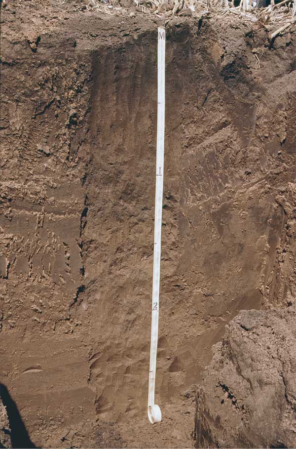
Table 3. Description of the soil profile in Trench 3.
| Landform: T-1 terrace Landscape Position: Natural levee on T-1 terrace Parent material: Alluvium Slope: 1-2% Land cover: Corn stubble |
||
| Depth (cm) | Soil Horizon | Description |
|---|---|---|
| 0-20 | Ap | Dark grayish brown (10YR 4/2) silt loam, very dark grayish brown (10YR 3/2) moist; weak fine granular structure; friable; few common fine and very fine roots; abrupt wavy boundary. |
| 20-42 | A | Dark grayish brown (10YR 4/2) silt loam, very dark grayish brown (10YR 3/2) moist; weak fine granular structure; friable; many fine and very fine roots; gradual smooth boundary. |
| 42-52 | BA | Brown (10YR 4/3) silty clay loam, very dark brown (10YR 3/3) moist; weak fine subangular blocky structure parting to moderate fine and medium granular structure; friable; common fine and very fine roots; gradual smooth boundary. |
| 52-90 | Bt1 | Yellowish brown (10YR 5/4) silty clay loam, dark yellowish brown (10YR 4/4) moist; moderate medium prismatic structure parting to moderate fine subangular blocky; very hard, very firm; many distinct continuous dark grayish brown (10YR 4/2) clay films on ped faces; few fine and very fine roots; gradual smooth boundary. |
| 90-140 | Bt2 | Yellowish brown (10YR 5/4) silty clay loam, dark yellowish brown (10YR 4/4) moist; few fine faint yellowish brown (10YR 5/6) mottles; moderate medium prismatic structure parting to moderate fine subangular blocky; very hard, very firm; common distinct continuous dark grayish brown (10YR 4/2) clay films on ped faces; few very fine soft iron and manganese oxide concretions; few fine and very fine roots; common fine and very fine pores; gradual smooth boundary. |
| 140-220 | Bt3 | Yellowish brown (10YR 5/4) silty clay loam, dark yellowish brown (10YR 4/4) moist; common fine faint yellowish brown (10YR 5/6) mottles; weak medium prismatic structure parting to weak fine subangular blocky; hard, firm; few faint discontinuous dark grayish brown (10YR 4/2) clay films on ped faces and in pores; common very fine and fine soft iron and manganese oxide concretions; few fine and very fine roots; many fine and very fine pores; gradual smooth boundary. |
| 220-260 | BC | Yellowish brown (10YR 5/4) silty clay loam, dark yellowish brown (10YR 4/4) moist; common fine distinct yellowish brown (10YR 5/6) and strong brown (7.5YR 5/6) mottles; very weak medium prismatic structure parting to very weak fine subangular blocky; hard, firm; common very fine and fine soft and few hard iron and manganese oxide concretions; many fine and very fine pores; gradual smooth boundary. |
| 260-300 | CB | Yellowish brown (10YR 5/4) silt loam, dark yellowish brown (10YR 4/4) moist; common fine distinct yellowish brown (10YR 5/6) and strong brown (7.5YR 5/6) mottles; very weak medium prismatic structure parting to very weak fine subangular blocky; soft, friable; common very fine and fine soft and few hard iron and manganese oxide concretions; common grayish brown (10YR 5/2) reductions zones along macro-pores; many fine and very fine and few medium and coarse pores. |
Trench 4 was excavated to a depth of 275 cm at Site 14BU520 in Archaeological Analytic Unit 3 (Figure 1). This trench was emplaced on the upper side-slope of the scarp separating the T-1 and T-0 surfaces. It exposed a surface soil (Soil 1) and two buried soils (Soils 2 and 3) (Figure 5 and Table 4). Soil 1 is 35 cm thick and has an Ap-AB profile; most of the A horizon has been stripped off by erosion. Soil 2 is at a depth of 35-97 cm and has an A-Bt profile. The Ab1 horizon is 25 cm thick and is dark grayish brown (10YR 4/2, dry) light silty clay loam. The Bt horizon of Soil 2 is welded onto the A horizon of Soil 3. This explains the presence of clay films on ped surfaces in the Atb2 horizon. Soil 3 is at least 178 cm thick and has a well expressed At-Bt-BC profile (Table 4).
Figure 5. Photograph of the east wall of Trench 4.
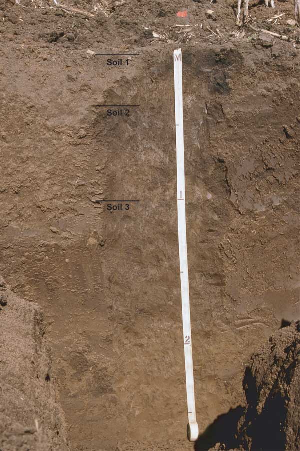
Table 4. Description of the soil profile in Trench 4.
| Landform: T-1 terrace Landscape Position: Upper side-slope of the scarp separating T-1 from T-0 Parent material: Alluvium Slope: 1-2% Land cover: Corn stubble |
||
| Depth (cm) | Soil Horizon | Description |
|---|---|---|
| 0-20 | Ap | Dark grayish brown (10YR 4/2) silt loam, very dark grayish brown (10YR 3/2) moist; weak fine granular structure; friable; few common fine and very fine roots; abrupt wavy boundary. |
| 20-35 | AB | 50% brown (10YR 4/3) silt loam, dark brown (10YR 3/3); 50% yellowish brown (10YR 5/4) silt loam, dark yellowish brown (10YR 4/4) moist; weak fine subangular blocky structure parting to moderate medium and coarse granular; friable; many worm casts and open worm burrows; many fine and very fine roots; clear smooth boundary. |
| 35-60 | Ab1 | Dark grayish brown (10YR 4/2) light silty clay loam, very dark grayish brown (10YR 3/2) moist; weak fine subangular blocky structure parting to moderate fine and medium granular; friable; many worm casts and open worm burrows; common fine and very fine roots; gradual smooth boundary. |
| 60-97 | Btb1 | Yellowish brown (10YR 5/4) silty clay loam, dark yellowish brown (10YR 4/4) moist; moderate medium prismatic structure parting to moderate fine subangular blocky; very hard, very firm; common distinct discontinuous dark grayish brown (10YR 4/2) clay films on ped faces; many worm casts; many worm burrows filled with dark grayish brown (10YR 4/2) silty clay loam; many krotovina 6-12 cm in diameter filled with dark grayish brown (10YR 4/2) silty clay loam; common fine and very fine roots; diffuse irregular boundary. |
| 97-140 | Atb2 | Brown (10YR 4/3) silty clay loam, dark brown (10YR 3/3) moist; weak fine subangular blocky structure parting to moderate medium and coarse granular; slightly hard, friable; common thin distinct discontinuous dark grayish brown (10YR 4/2) clay films on ped faces; common worm casts and open worm burrows; few fine and very fine roots; common fine and very fine pores; gradual smooth boundary. |
| 140-175 | Bt1b2 | Brown (10YR 4/3) to dark yellowish brown (10YR 4/4) silty clay loam, dark yellowish brown (10YR 4/4) moist; moderate medium prismatic structure parting to moderate fine subangular blocky; very hard, very firm; many distinct discontinuous dark grayish brown (10YR 4/2) clay films on ped faces; few worm casts and open worm burrows; few fine and very fine roots; common fine and very fine pores; gradual smooth boundary. |
| 175-250 | Bt2b2 | Yellowish brown (10YR 5/4) silty clay loam, dark yellowish brown (10YR 4/4) moist; moderate medium prismatic structure parting to moderate medium and fine subangular blocky; very hard, very firm; common distinct discontinuous dark grayish brown (10YR 4/2) clay films on ped faces; few worm casts and open worm burrows; few fine roots; common fine and very fine pores; gradual smooth boundary. |
| 250-275 | BCb2 | Yellowish brown (10YR 5/4) light silty clay loam, dark yellowish brown (10YR 4/4) moist; common fine faint yellowish brown mottles; very weak medium prismatic structure parting to very weak fine subangular blocky; hard, firm; many fine and very fine pores. |
The geologic potential for buried cultural deposits is ranked high at the Trench 4 locality. This interpretation is based on the presence of two buried soils developed in sediment that probably accumulated during the late Holocene. However, while the plow zone at site 14BU520 yielded lithics and ceramics, cultural materials were not found in the walls or floor of Trench 4.
Trench 5 was excavated to a depth of 275 cm at site 14BU1532 in Archaeological Analytic Unit 3 (Figure 1). This trench exposed a weakly developed surface soil with A-AB-Bw-BC horizonation developed in fine-grained alluvium beneath the floodplain (T-0) (Figure 6 and Table 5). The A horizon (Ap + A) is 36 cm thick and is dark grayish brown (10YR 4/2, dry) silty clay loam. Dark grayish brown (10YR 4/2, dry) silty clay loam composing a transitional AB horizon grades into brown (10YR 5/3, dry) to yellowish brown (10YR 5/4, dry) silty clay loam composing a cambic (Bw) horizon. The alluvium is laminated below a depth of 105 cm (BC and C horizons).
Figure 6. Photograph of the east wall of Trench 5.
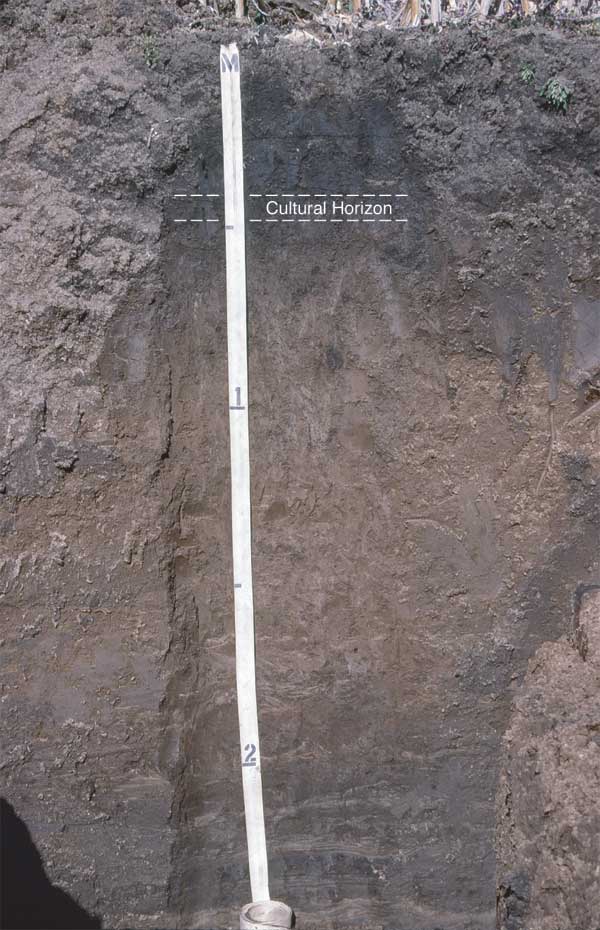
Table 5. Description of the soil profile in Trench 5.
| Landform: T-0 floodplain Landscape Position: Inside a meander loop Parent material: Alluvium Slope: 1% Land cover: Corn stubble Remarks: There is a cultural component in the AB horizon 36-51 cm below the T-0 surface. |
||
| Depth (cm) | Soil Horizon | Description |
|---|---|---|
| 0-20 | Ap | Dark grayish brown (10YR 4/2) light silty clay loam, very dark grayish brown (10YR 3/2) moist; weak fine granular structure; friable; few common fine and very fine roots; abrupt wavy boundary. |
| 20-36 | A | Dark grayish brown (10YR 4/2) light silty clay loam, very dark grayish brown (10YR 3/2) moist; weak fine granular structure; friable; many fine and very fine roots; many worm casts and open worm burrows; gradual smooth boundary. |
| 36-51 | AB | Dark grayish brown (10YR 4/2) to brown (10YR 4/3) light silty clay loam, very dark grayish brown (10YR 3/2) moist; weak fine subangular blocky structure parting to moderate fine granular structure; friable; common fine and very fine roots; common flecks of charcoal and burned earth; many worm casts and open worm burrows; common fine and very fine roots; gradual smooth boundary. |
| 51-105 | Bw | Brown (10YR 5/3) to yellowish brown (10YR 5/4) light silty clay loam, brown (10YR 4/3) to dark yellowish brown (10YR 4/4) moist; weak fine subangular blocky structure; friable; common worm casts and open worm burrows; common fine and very fine roots; common fine and very fine pores; gradual smooth boundary. |
| 105-135 | BC | Yellowish brown (10YR 5/4) light silty clay loam interbedded with faint laminae of pale brown (10YR 6/3) silt loam; dark yellowish brown (10YR 4/4) moist; very weak fine subangular blocky structure; soft, friable; few fine and very fine roots; gradual smooth boundary. |
| 135-190 | C1 | Stratified (laminated) pale brown (10YR 6/3), and brown (10YR 5/3 and 4/3) silt loam and silty clay loam; few fine distinct strong brown (7.5YR 5/8) mottles; massive; soft, friable; few very fine roots; common fine and very fine pores; abrupt wavy boundary. |
| 190-275 | C2 | Stratified (laminated) dark grayish brown (10YR 4/4) silty clay loam, very dark grayish brown (10YR 3/2) moist, interbedded with pale brown (10YR 6/3) and very pale brown (10YR 7/3) silt loam; common fine and few medium prominent strong brown (7.5YR 5/8), yellowish red (5YR 5/8), dark red (2.5YR 3/6), red (10R 4/6) and dark red (10R 3/6) mottles; massive; soft, friable; few very fine roots; common fine and very fine pores. |
The numerical age of the T-0 fill at the Trench 5 locality is unknown. However, based on its low position in the valley landscape and the weakly developed surface soil, the T-0 fill exposed in Trench 5 probably is less than 2000 years old.
No buried soils were exposed in the upper 275 cm of the T-0 fill in Trench 5. Hence, there is only moderate geologic potential for buried cultural deposits at this locality. Nevertheless, a cultural component consisting of charcoal, burned earth, and ceramics was recorded at a depth of 36-46 cm below the T-0 surface. The archaeological materials are in the AB horizon of the modern soil.
Trenches 6 and 7 were excavated on the T-0 surface at sites 14BU519 and 14BU1531, respectively. Both trenches exposed in situ cultural deposits more than 50 cm below the land surface.
Based on the results of the geomorphological investigation, there is low geologic potential for buried cultural resources in Archaeological Analytic Unit 1. No buried soils were observed in the upper 3 m of the T-1 fill, and subsurface exploration did not yield any buried artifacts or cultural features in this portion of the project area. Hence, additional deep testing is unnecessary in Archaeological Analytic Unit 1.
The results of subsurface exploration indicate there is moderate to high geologic potential for buried cultural resources in Archaeological Analytic Unit 3. This potential was realized at sites 14BU1532, 14BU1531, and 14BU519, which have buried prehistoric cultural components in T-0 fill. Therefore, deep archaeological testing is recommended for these three sites.
Artz, J. A., 1983, The soils and geomorphology of the East Branch Walnut Valley: contexts of human adaptation in the Kansas Flint Hills: Unpublished M.A. thesis, Department of Anthropology, University of Kansas, Lawrence.
Artz, J. A., 1985, A soil-geomorphic approach to locating buried Late-Archaic sites in northeast Oklahoma: American Archaeology, 5: 142-150.
Bettis, E. A., III, and Littke, J. P., 1987, Holocene Alluvial Stratigraphy and Landscape Development in Soap Creek Watershed, Appanoose, Davis, Monroe, and Wapello Counties, Iowa: Iowa Department of Natural Resources, Geological Survey Bureau, Open File Report 87-2, Iowa City.
Birkeland, P. W., 1999, Soils and Geomorphology: Oxford University Press, Oxford.
Hoyer, B.E., 1980, The Geology of the Cherokee Sewer Site, in The Cherokee Excavations: Holocene Ecology and Human Adaptations in Northwestern Iowa, edited by D. C. Anderson and H. A. Semken, Jr.: Academic Press, New York, pp. 21-66.
Mandel, R. D., 1992, Soils and Holocene landscape evolution in central and southwestern Kansas, in Soils in Archaeology, edited by V. T. Holliday, V. T.: Smithsonian Institution Press, Washington, D. C., pp. 41-117.
Mandel, R. D., 1994a, Geoarcheology of the Lower Walnut River Valley at Arkansas City, Kansas: The Kansas Anthropologist, 15:46-69.
Mandel, R. D., 1994b, Holocene Landscape Evolution in the Pawnee River Valley, Southwestern Kansas: Kansas Geological Survey, Bulletin 236, Lawrence.
Mandel, R. D., 1995, Geomorphic controls of the Archaic record in the Central Plains of the United States, in Archaeological Geology of the Archaic Period in North America, edited by E. A. Bettis III: Geological Society of America Special Paper 297, Boulder, Colorado, pp. 37-66.
Mandel, R.D., and Bettis, E.A., III, 2001, Use and Analysis of Soils by Archaeologists and Geoscientists: A North American Perspective, in Earth Sciences and Archaeology, edited by P. Goldberg V.T. Holliday, and C. Reid Ferring, pp. 173-204. Kluwer Academic/Plenum Publishing. New York.
Soil Survey Staff, 1992, Keys to Soil Taxonomy: SMSS Technical Monograph No. 19, Virginia Polytechnic Institute and State University, Blacksburg, Virginia.
Kansas Geological Survey, Geology
Placed online Jan. 25, 2006
Comments to webadmin@kgs.ku.edu
The URL for this page is http://www.kgs.ku.edu/Publications/OFR/2005/OFR05_02/index.html