Kansas Geological Survey, Open-file Report 1997-15
KGS Open File Report 1997-15
The table included in this report represents a compilation of oil-gravity data in the Forest City basin in northeastern Kansas, southeastern Nebraska, and northwestern Missouri. Oil in the Forest City basin is mostly an Ordovician-type oil with a unique geochemical character (Longman and Palmer, 1987; Hatch and others, 1987; Newell and others, 1987; Hatch and Newell, in preparation). The unique geochemical characteristics of Ordovician-type oils are: a strong preference in odd-number normal alkanes from C11 to C19, low relative amounts of heavier normal alkanes, and relatively low amounts of steranes and hopanes including pristane and phytane (Martin and others, 1963; Reed and others, 1986). These oils have been attributed to the organic-walled microfossil Gloeocapsomorpha prisca (Reed and others, 1986; Fowler, 1992). Due to incomplete fill-up of structures and their location deep within the basin, the Ordovician-type oils in the Forest City basin were probably generated within the immediate drainage areas of the traps that hold them, and are not the product of long-distance migration (Jenden and others, 1988).
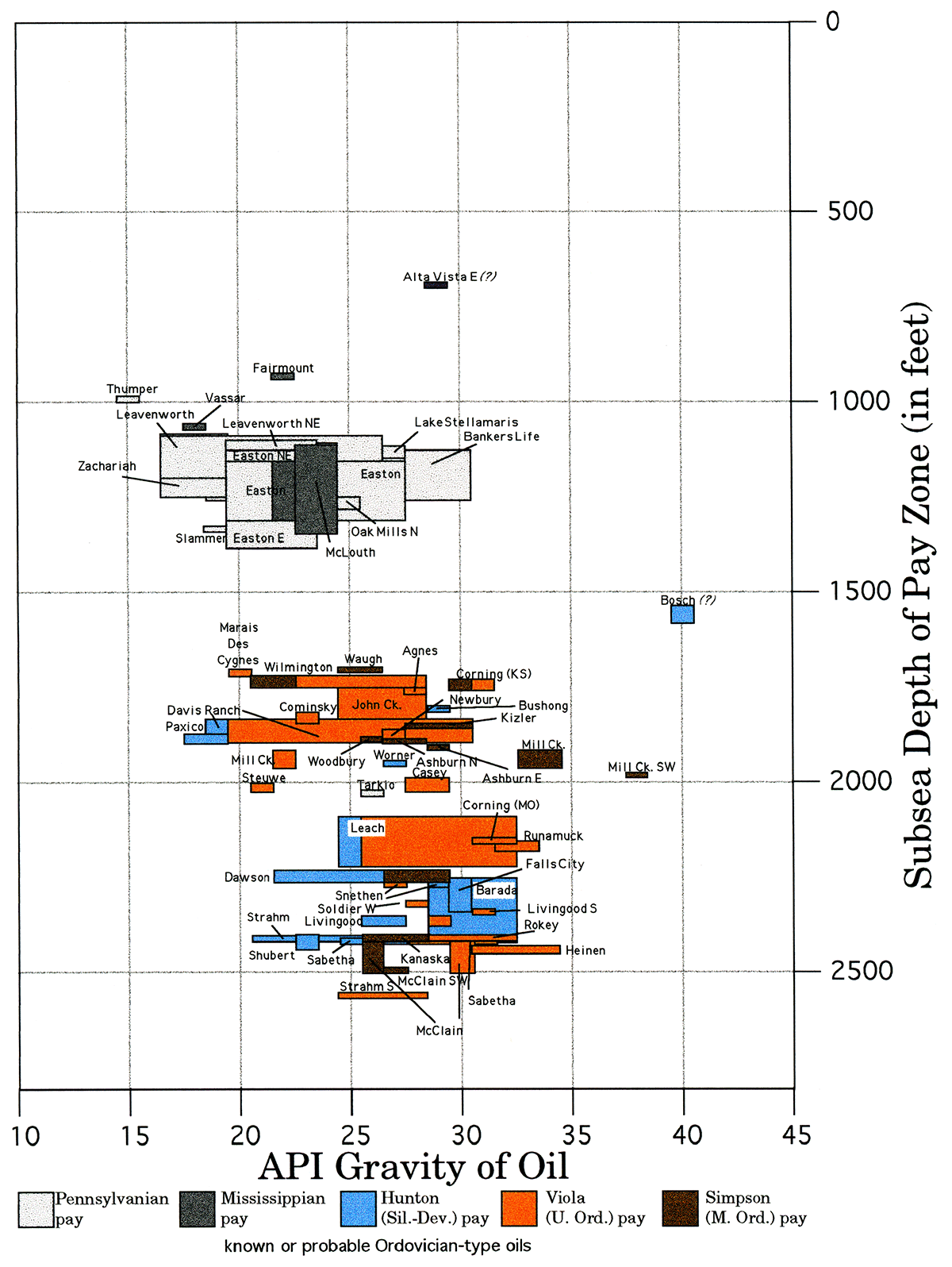
The source documents for subsea and subsurface production depths in the compilation of oil-gravity data (Table 1) are scout cards for producing wells, which are available at the Kansas Geological Survey. Oil gravities were also obtained from these cards and from other sources that are footnoted on the table. Information in the table is summarized in two figures showing the variation of oil gravity with subsea depth (Figure 1) and with the projected subsea depth of the Middle Ordovician Simpson Group at each oil field (Figure 2). In some localities the Ordovician-type oils have apparently leaked vertically upward into shallower reservoirs, such as into the Silurian-Devonian "Hunton" group along the axis of the basin, and even into Mississippian and Pennsylvanian pay zones at the complex of oil fields at Easton and McLouth on the eastern flank of the basin. The plotting of oil gravities according to the depth of the underlying Simpson Group is an attempt to plot the variations in oil-gravity vs. the approximate depth of their most-likely source rocks.
A general increase in oil gravity with increasing depth occurs within the Forest City basin (Figures 1, 2). The increase of oil gravity with depth appears more tightly constrained when plotted according to the depth of the Simpson Group (Figure 2). It is unclear whether the upward decrease in oil gravity is due to temperature of the locality where the oil was generated, effects of migration up through the stratigraphic column, or the physical conditions in the reservoir. Geochemistry may provide answers. Oil fields that are significantly off the oil gravity-depth trends in Figures 1 and 2 (e.g., Bosch, Mill Creek Southwest, and Alta Vista East fields) may contain geochemically separate types of oil.
Fowler, M.G., 1992, The influence of Gloeocapsomorpha prisca on the organic geochemistry of oils and organic-rich rocks of Late Ordovician age from Canada; in, Early organic evolution: implications for mineral and energy resources, M.S. Schidlowski, S. Golubic, M.M. Kimberly, D.M. McKirdy, and P.A. Trudinger, eds.: Berlin, Springer-Verlag, p. 336-356.
Hatch, J.R., Jacobson, S.R., Witzke, B.J., Risatti, J.B., Anders, D.E., Watney, W.L., Newell, K.D., and Vuletich, A.K., 1987, Possible Late Middle Ordovician organic carbon isotope excursion; evidence from Ordovician oils and hydrocarbon source rocks, Mid-Continent and east-central United States: American Association of Petroleum Geologists Bulletin, v. 71, p. 1342-1354.
Hatch, J.R., and Newell, K.D., in preparation, Geochemistry of oils and hydrocarbon source rocks, Forest City basin, northeastern Kansas and adjacent areas in Missouri, Iowa, and Nebraska.
Jenden, P.D., Newell, K.D., Kaplan, I.R, and Watney, W.L., 1988, Composition and stable isotope geochemistry of natural gases from Kansas, Midcontinent, U.S.A.: Chemical Geology, v. 71, p. 117-147.
Longman, M.W., and Palmer, S.E., 1987, Organic geochemistry of Mid-Continent Middle and Late Ordovician oils: American Association of Petroleum Geologists, Bulletin, v. 71, p. 938-950.
Martin, R.L., Winters, J.C., and Williams, J.A., 1963, Distributions of n-paraffins in crude oils and their implications to origin of petroleum: Nature, v .199, p. 110-113.
Newell, K.D., Watney, W.L., Stephens, B.P., and Hatch, J.R., 1987, Hydrocarbon potential in Forest City basin: Oil and Gas Journal, Oct. 19th, p. 58-62.
Reed, J.D., Illich, H.A., and Horsfield, B., 1985, Biochemical evolutionary significance of Ordovician oils and their sources: Organic Geochemistry, v. 10, p. 347-358.
Table 1—Oil gravities and production depths for oil field in the central part of the Forest City basin and adjacent areas. Depth to Simpson is estimated for each oil field. Data were compiled from scout cards available at the Kansas Geological Survey except where noted. Fields are arranged according to location from north to south in the basin.
| Location | Field Name |
Pay Zone | Subsurface Depth (feet) |
Subsea Depth |
Subsea Depth of Simpson (feet) |
Gravity Range (API°) |
Notes |
|---|---|---|---|---|---|---|---|
| 32-T. 65 N.-R. 39 W. | Tarkio (Missouri) |
Cherokee (Penn.) |
1330-1451 | -360 | ~ -2025 | 261 | |
| 15-T. 63 N.-R. 40 W. | Runamuck (Missouri) |
Maquoketa | 2820 | -1909 | ~ -2160 to -2180 | 33 | oil show |
| 15, 16, 21-T. 63 N.-R. 40 W. | Runamuck (Missouri) |
Viola | 2780 - 2813 | -1895 to -1923 | ~ -2160 to -2180 | 32 - 33 | |
| 21-T. 63 N. - R. 40 W. | Corning (Missouri) |
Viola | 2960 - 2975 | -1990 to -2005 | ~ -2150 | 31 - 32 | |
| 25, 26, 29, 35, 36-T. 3 N. - R. 16 E. 1, 2, 3, 11, 15-T. 2 N. - R. 16 E. |
Barada (Nebraska) |
Hunton | 2354 - 2513 | -1289 to -1453 | ~ -2250 to -2420 | 29 - 32 | |
| 31, 32-T. 3 N. - R. 16 E. | Shubert (Nebraska) |
Hunton | 2446 - 2540 | -1434 to -1480 | ~ -2400 to -2440 | 232 | |
| 29-T. 2 N. - R. 14 E. | Snethen (Nebraska) |
Hunton | 2390 | -1275 | ~ -2260 to -2270 | 292 | |
| 29-T. 2 N.-R. 14 E. | Snethen (Nebraska) |
Viola | 3080 - 3106 | -2030 to -2042 | ~ -2260 to -2270 | 272 | |
| 2, 3, 9, 10, 11, 13-T. 1 N.-R. 14 E. | Dawson (Nebraska) |
Hunton | 2130 - 2202 | -1188 to -1248 | ~ -2230 to -2260 | 22 - 282 | |
| 2, 3, 9, 10, 11, 13-T. 1 N.-R. 14 E. | Dawson (Nebraska) |
Viola | 2854 - 2905 | -1918 to -1930 | ~ -2230 to -2260 | 27 - 292 | commingled with Simpson |
| 2, 3, 9, 10, 11, 13-T. 1 N.-R. 14 E. | Dawson (Nebraska) |
Simpson | 3182 - 3198 | -2232 to -2255 | ~ -2230 to -2260 | 27 - 292 | commingled with Viola |
| 7, 8, 17, 18, 20, 29-T. 1 N.-R. 16 E. | Falls City (Nebraska) |
Hunton | 2211 - 2353 | -1312 to -1401 | ~ -2300 to -2390 | 303 | |
| 1-T. 1 S.-R. 14 E. | Kanaska | Simpson | 3510 - 3530 | -2393 to -2412 | ~ -2400 to -2410 | 26 - 28 | |
| 3, 4, 10-T. 1 S.-R. 15 E. | Livingood | Hunton | 2568 - 2643 | -1493 to -1526 | ~ -2350 to -2370 | 26 - 27 | |
| 3, 4, 10-T. 1 S.-R. 15 E. | Livingood | Viola | 3280 - 3343 | -2185 to -2200 | ~ -2350 to -2370 | 30 | |
| 10-T. 1 S.-R. 15 E. | Livingood South |
Viola | 3309 - 3314 | -2180 to -2185 | ~ -2340 to -2350 | 31 | |
| 3, 4, 10-T. 2 S.-R. 15 E. | Rokey | Viola | 3532 - 3555 | -2229 to -2243 | ~ -2400 to -2410 | 29 - 32 | |
| 13, 14-T. 2 S.-R. 15 E. | Sabetha | Hunton | 2840 - 2862 | -1579 to -1618 | ~ -2410 to -2420 | 25 - 28 | |
| 13, 14-T. 2 S.-R. 15 E. | Sabetha | Viola | 3461 - 3560 | -2224 to -2271 | ~ -2410 to -2420 | 28 - 31 | |
| 26, 27-T. 2 S.-R. 14 E. | Strahm | Hunton | 2768 - 2918 | -1460 to -1594 | ~ -2410 to -2420 | 21 - 26 | |
| 26, 27-T. 2 S.-R. 14 E. | Strahm | Viola | 3566 - 3583 | -2246 to -2264 | ~ -2410 to -2420 | 27 - 29 | |
| 34-T. 2 S.-R. 14 E. 3- T. 3 S.-R. 14 E. |
Strahm South |
Viola | 3568 - 3617 | -2332 to -2356 | ~ -2550 to -2560 | 24 - 28 | |
| 34-T. 2 S.-R. 14 E. 3- T. 3 S.-R. 14 E. |
Strahm South |
Simpson | 3779 - 3782 | -2553 to -2556 | ~ -2550 to -2560 | not available | |
| 24-T. 4 S.-R. 13 E. | McClain Southwest |
Viola | 3502 - 3506 | -2274 to -2278 | ~ -2490 to -2500 | 27 | commingled with Simpson |
| 24-T. 4 S.-R. 13 E. | McClain Southwest |
Simpson | 3714 - 3716 | -2486 to -2488 | ~ -2490 to -2500 | 27 | commingled with Viola |
| 35-T. 4 S.-R. 13 E. 3- T. 5 S.-R. 13 E. |
Heinen | Viola | 3580 - 3682 | -2303 to -2321 | ~ -2430 to -2450 | 31 - 34 | |
| 7, 8, 17, 18-T. 4 S.-R. 14 E. | McClain | Viola | 3365 - 3494 | -2185 to -2264 | ~ -2400 to -2500 | 30 | |
| 7, 8, 17, 18-T. 4 S.-R. 14 E. | McClain | Simpson | 3593 - 3708 | -2402 to -2504 | ~ -2400 to -2500 | 26 | |
| 14, 23-T. 5 S.-R. 12 E. | Corning | Viola | 2426 - 2516 | -1113 to -1204 | ~ -1340 to -1350 | 30 - 31 | |
| 14, 23-T. 5 S.-R. 12 E. | Corning | Simpson | 2649 - 2696 | -1336 to -1356 | ~ -1340 to -1350 | 30 | commingled with Viola |
| 36-T. 5 S.-R. 12 E. | Corning South |
Simpson | 3352 - 3360 | -2056 to -2062 | ~ -2060 | not available | |
| 9-T. 5 S.-R. 13 E. | Hermesch | Viola | 3612 - 3622 | -2273 to -2283 | ~ -2400 to -2410 | 27 - 284 | |
| 20-T. 5 S.-R. 14 E. | Mosquito Creek |
Viola | 3590 | -2345 | ~ -2470 | not available | |
| 27, 34-T. 6 S.-R. 13 E. | Soldier West | Viola | 3410 - 3416 | -2187 to -2199 | ~ -2320 to -2330 | 28 | |
| 35-T. 6 S.-R. 13 E. | Soldier | Hunton | 2856 | -1648 | ~ -2310 | not available | |
| 9, 10-T. 7 S.-R. 12 E. | Casey | Viola | 3294 - 3337 | -1905 to -1951 | ~ -1990 to -2030 | 23 - 24 | |
| 14, 15, 21, 22-T. 7 S.-R. 13 E. | Leach | Hunton | 2659 - 2783 | -1530 to -1594 | ~ -2080 to -2220 | 26 - 28 | |
| 14, 15, 21, 22-T. 7 S.-R. 13 E. | Leach | Viola | 3207 - 3313 | -2089 to -2129 | ~ -2080 to -2220 | 26 - 32 | |
| 19-T. 7 S.-R. 17 E. | Worner | Hunton | 2375 - 2377 | -1352 to -1354 | ~ -1950 | 27 | |
| 27-T. 7 S.-R. 13 E. | Misener (Dev.- Mississippian) |
2879 - 2890 | -1581 to -1592 | ~ -2280 | 30 | noncommercial oil show |
|
| 23, 24, 25, 26-T. 7 S.-R. 21 E. | Oak Mills North |
McLouth (Penn.) |
1285 - 1460 | -363 to -406 | ~ -1250 to -1280 | 25 | |
| 24, 25-T. 8 S.-R. 20 E. 18, 19, 20-T. 8 S.-R. 21 E. 3- T. 9 S.-R. 20 E. |
Easton | McLouth (Penn.) |
1271 - 1519 | -334 to -497 | ~ -1160 to -1310 | 19 - 27 | |
| 24, 25-T. 8 S.-R. 20 E. 18, 19, 20-T. 8 S.-R. 21 E. 3- T. 9 S.-R. 20 E. |
Easton | Mississippian | 1316 - 1500 | -430 to -556 | ~ -1160 to -1310 | 22 | |
| 3-T. 8 S.-R. 21 E. | Lowemont | McLouth (Penn.) |
1449 - 1454 | -363 to -368 | ~ -1170 | not available | |
| 8, 9, 17-T. 8 S.-R. 21 E. | Easton Northeast |
McLouth/ Burgess (Penn.) |
1350 - 1498 | -331 to -465 | ~ -1130 to -1260 | 19 - 24 | |
| 8, 9, 17-T. 8 S.-R. 21 E. | Easton Northeast |
Mississippian | 1445 - 1487 | -395 to -416 | ~ -1130 to -1260 | 23 | |
| 11, 12, 13-T. 8 S.-R. 21 E. 18, 19-T. 8 S.-R. 22 E. |
Leavenworth Northeast |
McLouth/ Burgess (Penn.) |
1166 - 1370 | -299 to -477 | ~ -1100 to -1280 | 20 - 23 | |
| 13, 14-T. 8 S.-R. 21 E. | Apple Valley | McLouth/ Burgess (Penn.) |
1179-1377 | -309 to -398 | ~ -1110 to -1180 | 19 - 24 | |
| 15, 16, 21, 22, 28-T. 8 S.-R. 21 E. | Easton East | McLouth (Penn.) |
1280 - 1505 | -327 to -485 | ~ -1130 to -1270 | 20 - 24 | |
| 15, 16, 21, 22, 28-T. 8 S.-R. 21 E. | Easton East | Mississippian | 1424 - 1578 | -389 to -482 | ~ -1130 to -1270 | 23 | |
| 23-T. 8 S.-R. 21 E. | Leavenworth West |
McLouth (Penn.) |
1337 - 1420 | -318 to -361 | ~ -1120 to -1160 | 23 - 24 | |
| 23-T. 8 S.-R. 21 E. | Leavenworth West |
Mississippian | 1390 - 1412 | -350 to -362 | ~ -1120 to -1160 | 23 | |
| 23-T. 8 S.-R. 21 E. | Leavenworth | McLouth (Penn.) |
1257 - 1434 | -286 to -402 | ~ -1090 to -1200 | 17 - 26 | |
| 27, 34-T. 8 S.-R. 21 E. | Lake Stellamaris |
McLouth (Penn.) |
1400 - 1467 | -323 to -352 | ~ -1120 to -1150 | 23 - 27 | |
| 19, 20-T. 8 S.-R. 22 E. | Slammer Northeast |
McLouth/ Burgess (Penn.) |
1152-1233 | -266 to -373 | ~ -1070 to -1170 | not available | |
| 20-T. 8 S.-R. 22 E. | Corral Creek | McLouth (Penn.) |
1160 - 1257 | -310 to -357 | ~ -1110 to -1160 | 22 | |
| 28, 32-T. 8 S.-R. 22 E. | Corral Creek Southeast |
McLouth (Penn.) |
1305 - 1307 | -345 to -347 | ~ -1150 | not available | |
| 28, 32-T. 8 S.-R. 22 E. | Corral Creek Southeast |
Mississippian | 1449 - 1452 | -389 to -392 | ~ -1150 | not available | |
| 29, 32-T. 8 S.-R. 22 E. 5-T. 9 S.-R. 22 E. |
Possum Hollow Northeast |
McLouth/ Burgess (Penn.) |
1280 - 1462 | -323 to -397 | ~ -1120 to -1180 | 20 | |
| 30-T. 8 S.-R. 22 E. | Slammer | McLouth/ Burgess (Penn.) |
1438 - 1446 | -528 to -532 | ~ -1330 | 19 | |
| 33-T. 8 S.-R. 22 E. | Christy | McLouth/ Burgess (Penn.) |
1398 - 1440 | -330 to -401 | ~ -1130 to -1190 | 19 - 20 | |
| 6-T. 9 S.-R. 22 E. | Possum Hollow |
McLouth/ Burgess (Penn.) |
1312 - 1489 | -342 to -384 | ~ -1140 to -1180 | 24-27 | |
| 7-T. 9 S.-R. 20 E. | Zachariah West |
McLouth (Penn.) |
1402 - 1408 | -412 to -418 | ~ -1200 | 23 | |
| 8, 17, 19, 20, 21, 29-T. 9 S.-R. 20 E. | McLouth North |
McLouth (Penn.) |
1408 - 1526 | -381 to -504 | ~ -1180 to -1300 | 19 - 26 | |
| 9-T. 9 S.-R. 20 E. | Zachariah | McLouth/ Cherokee (Penn.) |
1376 - 1490 | -280 to -459 | ~ -1080 to -1250 | 17 - 19 | |
| 23, 24-T. 9 S.-R. 20 E. | Tullis | McLouth/ Burgess (Penn.) |
1376 - 1410 | -363 to -390 | ~ -1160 to -1183 | 23 | |
| 28-T. 9 S.-R. 20 E. 4, 5, 8-T. 10 S.-R. 20 E. |
McLouth | McLouth (Penn.) |
1442 - 1472 | -371 to -401 | ~ -1110 to -1350 | 245 | |
| 28-T. 9 S.-R. 20 E. 4, 5, 8-T. 10 S.-R. 20 E. |
McLouth | Mississippian | 1513 - 1680 | -362 to -600 | ~ -1110 to -1350 | 23 - 24 | |
| 12, 14-T. 9 S.-R. 21 E. | Fred | Burgess (Penn.) | 1418 - 1421 | -344 to -347 | ~ -1120 to -1150 | not available | |
| 12, 14-T. 9 S.-R. 21 E. | Fred | Mississippian | 1306 - 1360 | -320 to -359 | ~ -1120 to -1150 | not available | |
| 28-T. 9 S.-R. 22 E. | Aufdemberge | Burgess (Penn.) | 1303 - 1307 | -292 to -296 | ~ -1090 to -1100 | 18 | |
| 17-T. 9 S.-R. 23 E. | Thumper | McLouth (Penn.) |
948 - 960 | -187 to -199 | ~ -990 to -1000 | 15 | |
| 3, 10-T. 10 S.-R. 20 E. | Bankers Life | McLouth (Penn.) |
1329 - 1494 | -329 to -467 | ~ -1130 to -1260 | 21 - 30 | |
| 7, 17, 18-T. 10 S.-R. 20 E. | McLouth South |
McLouth (Penn.) |
1445 - 1516 | -393 to -478 | ~ -1190 to -1270 | 22 - 23 | |
| 27-T. 10 S.-R. 20 E. | State Lake | McLouth (Penn.) |
1324 - 1377 | -329 to -382 | ~ -1130 to -1180 | 18 | |
| 6, 7-T. 10 S.-R. 21 E. | Ackerland | McLouth (Penn.) |
1352 - 1408 | -352 to -373 | ~ -1150 to -1170 | not available | |
| 9, 10, 15-T. 10 S.-R. 21 E. | Jarbalo East | McLouth (Penn.) |
1171 - 1282 | -313 to -348 | ~ -1110 to -1140 | 21 - 24 | |
| 16-T. 10 S.-R. 21 E. | Jarbalo | McLouth (Penn.) |
1190 - 1244 | -308 to -338 | ~ -1110 to -1130 | 19 | |
| 12-T. 10 S.-R. 22 E. | Fairmount | Mississippian | 1103 - 1105 | -182 to -184 | ~ -930 | 22 | |
| 21-T. 11 S.-R. 7 E. | Ogden | basal Penn. cgl. | 1602 - 1686 | -492 to -525 | ~ -1280 to -1300 | 33 | |
| 22-T. 11 S.-R. 8 E. | Yaege Northwest |
Mississippian | 1553 - 1626 | -385 to -421 | ~ -900 to -930 | 34 | |
| 25, 26, 36-T. 11 S.-R. 8 E. 30, 31-T. 11 S.-R. 9 E. |
Yaege | basal Penn. cgl. & Hunton |
1504-1776 | -268 to -374 | ~ -750 to -850 | 30 - 33 | |
| 26-T. 11 S.-R. 8 E. | Ge-See | basal Penn. cgl. | 1633 - 1761 | -385 to -410 | ~ -1120 | not available | |
| 26-T. 11 S.-R. 8 E. | Ge-See | Mississippian | 1804 - 1809 | -474 to -479 | ~ -1120 | not available | |
| 29-T. 11 S.-R. 8 E. | Gerril | basal Penn. ss. | 1821 - 1824 | -358 to -361 | ~ -1120 | 30 | |
| 2, 11-T. 11 S.-R. 11 E. | Newbury | Viola | 2861 - 2904 | -1755 to -1777 | ~ -1860 to -1890 | 27 | |
| 22, 23-T. 11 S.-R. 11 E. | Paxico | Hunton | 2411 - 2460 | -1401 to -1426 | ~ -1870 to -1900 | 18 - 19 | |
| 18, 19-T. 12 S.-R. 11 E. | Steuwe | Viola | 3173 - 3183 | -1901 to -1925 | ~ -2000 to -2020 | 21 | |
| 2-T. 13 S.-R. 10 E. | Mill Creek | Viola | 2917 - 2930 | -1818 to -1834 | ~ -1940 to -1950 | 22 | |
| 2-T. 13 S.-R. 10 E. | Mill Creek | Simpson | 3037 - 3053 | -1939 to -1953 | ~ -1940 to -1950 | 33 - 34 | |
| 11-T. 13 S.-R. 10 E. | Mill Creek Southwest |
Simpson | 3186 - 3218 | -1977 to -1990 | ~ -1980 to -1990 | 38 | |
| 22-T. 13 S.-R. 10 E. | Davis Ranch Northeast |
Viola | 3230 - 3235 | -1838 to -1842 | ~ -1930 | not available | |
| 28, 33, 34-T. 13 S.-R. 10 E. 4-T. 14 S..-R. 10 E. |
Davis Ranch | Kansas City | 1811- 1884 | -388 to -464 | ~ -1830 to -1900 | 306 | |
| 28, 33, 34-T. 13 S.-R. 10 E. 4-T. 14 S.-R. 10 E. |
Davis Ranch | Hunton | 2931 - 2938 | -1506 to -1513 | ~ -1830 to -1900 | 19 | |
| 28, 33, 34-T. 13 S.-R. 10 E. 4-T. 14 S.-R. 10 E. |
Davis Ranch | Viola | 3113 - 3208 | -1738 to -1800 | ~ -1830 to -1900 | 20 - 30 | |
| 10-T. 14 S.-R. 8 E. | Alta Vista | Hunton | 1928 - 1930 | -448 to -450 | ~ -730 | not available | |
| 11-T. 14 S.-R. 8 E. | Alta Vista East |
Hunton | 1893 - 1898 | -413 to -426 | ~ -690 | 29 | |
| 20-T. 14 S.-R. 10 E. | Ashburn North |
Viola | 3290 - 3291 | -1775 to -1776 | ~ -1890 to -1900 | 28 | |
| 20-T. 14 S.-R. 10 E. | Ashburn North |
Simpson | 3404 - 3420 | -1890 to -1898 | ~ -1890 to -1900 | 27 - 28 | |
| 28-T. 14 S.-R. 10 E. | Ashburn East | Simpson | 3380 | -1903 | ~ -1900 | 24 | |
| 29-T. 14 S.-R. 10 E. | Ashburn | Viola | 3237 - 3266 | -1748 to -1769 | ~ -1840 to -1860 | 22 - 257 | |
| 32-T. 14 S.-R. 10 E. | Ashburn South |
Viola | 3240 - 3255 | -1749 to -1764 | ~ -1840 to -1860 | not available | |
| 20, 29-T. 14 S.-R. 12 E. | Wilmington | Hunton | 2860 - 2865 | -1456 to -1461 | ~ -1720 to -1740 | "low gravity", "tarry" |
|
| 20, 29-T. 14 S.-R. 12 E. | Wilmington | Viola | 2991 - 3012 | -1598 to -1622 | ~ -1720 to -1740 | 22 - 28 | |
| 20, 29-T. 14 S.-R. 12 E. | Wilmington | Simpson | 3115 - 3133 | -1716 to -1742 | ~ -1720 to -1740 | 21 - 228 | |
| 31-T. 14 S.-R. 12 E. | Marais Des Cygnes |
Viola | 2940 - 2952 | -1607 to -1619 | ~ -1710 to -1720 | 20 | |
| 22, 23, 24, 25, 26, 27, 34, 35- T. 15 S.-R. 9 E. 2- T. 16 S.-R. 9 E. |
John Creek | Viola | 2960 - 3184 | -1635 to -1753 | ~ -1720 to -1840 | 25 - 28 | |
| 2, 11-T. 15 S.-R. 10 E. | Woodbury | Viola | 3186 - 3228 | -1765 to -1807 | ~ -1870 to -1880 | 20 - 26 | |
| 2, 11-T. 15 S.-R. 10 E. | Woodbury | Simpson | 3270 - 3294 | -1871 to -1883 | ~ -1870 to -1880 | 26 | |
| 16-T. 15 S.-R. 11 E. | Wheat | Simpson | 3230 - 3234 | -1799 to -1803 | ~ -1800 | not available | |
| 7-T. 15 S.-R. 12 E. | Waugh | Simpson | 3055 - 3068 | -1695 to -1702 | ~ -1690 to -1700 | 25 - 26 | |
| 13, 24-T. 16 S.-R. 7 E. 18, 19-T. 16 S.-R. 8 E. |
Bosch | Hunton | 2719 - 2766 | -1269 to -1306 | ~ -1530 to -1570 | 405 | |
| 12, 13-T. 16 S.-R. 9 E. | John Creek Southeast |
Viola | 2958 - 2960 | -1714 to -1716 | ~ -1800 | not available | |
| 13, 23-T. 16 S.-R. 9 E. | Comiskey Northeast |
Viola | 2915 - 2959 | -1670 to -1702 | ~ -1760 to -1780 | 25 | gravity from nearby DST |
| 23, 24-T. 16 S.-R. 9 E. | Comiskey | Viola | 2926 - 2959 | -1679 to -1713 | ~ -1770 to -1790 | 23 | |
| 5-T. 16 S.-R. 10 E. | Agnes | Viola | 3108 - 3125 | -1722 to -1737 | ~ -1810 to -1820 | 28 | |
| 9, 16-T. 16 S.-R. 10 E. | Kizler North | Hunton | 2916 - 2970 | -1638 to -1649 | ~ -1840 to -1850 | 23 - 25 | |
| 16-T. 16 S.-R. 10 E. | Kizler | Simpson | 3197 - 3292 | -1823 to -1849 | ~ -1820 to -1840 | 28 - 30 | |
| 23, 26-T. 16 S.-R. 10 E. | Bushong | Hunton | 2948 - 2968 | -1601 to -1613 | ~ -1800 to -1810 | 29 | |
| 24-T. 16 S.-R. 16 E. | Vassar | Mississippian | 1508 - 1510 | -437 to -439 | ~ -1060 | 18 | |
| 13-T. 17 S.-R. 11 E. | Hagins | Simpson | 2874 - 2876 | -1617 to -1619 | ~ -1620 | not available |
1Wells, J., 1960, Tarkio field; in, Curtis, G.R., James, A., III, King, C.R., Lewis, J.P., eds., Kansas oil and fields, v. III (northeastern Kansas): Kansas Geological Society, Wichita, KS, p. 204-207.
2Personal communciation, 9/96, Marvin Carlson (Nebraska Geological Survey) to K. David Newell (Kansas Geological Survey).
3Brandt, E.O., 1960, Falls City field; in, Curtis, G.R., James, A., III, King, C.R., Lewis, J.P., eds., Kansas oil and fields, v. III (northeastern Kansas): Kansas Geological Society, Wichita, KS, p. 216-220.
4Longman, M.W., and Palmer, S.E., 1987, Organic geochemistry of Mid-Continent Middle and Late Ordovician oils: American Association of Petroleum Geologists, Bulletin, v. 71, p. 939-950.
5Beene, D.L., 1993, 1992 oil and gas production in Kansas: Kansas Geological Survey, Oil and Gas Production, Data Set 92, 269 p. (computer printout).
6Report from Mobil Field Research Laboratory (undated, but circa 1985) to K. David Newell (Kansas Geologcial Survey).
7Brinegar, W.L., Ashburn field; in, Curtis, G.R., James, A., III, King, C.R., Lewis, J.P., eds., Kansas oil and fields, v. III (northeastern Kansas): Kansas Geological Society, Wichita, KS, p. 10-13.
8Young, R.T., 1960, Wilmington field; in, Curtis, G.R., James, A., III, King, C.R., Lewis, J.P., eds., Kansas oil and fields, v. III (northeastern Kansas): Kansas Geological Society, Wichita, KS, p. 173-180.
Figure 1—API gravity of oils in the central part of the Forest City basin.
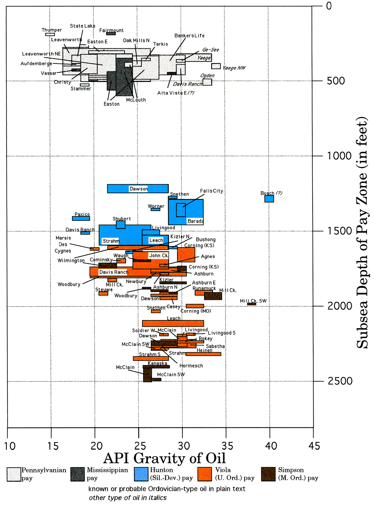
Figure 2—API gravity of oils in the central part of the Forest City basin (at depth of Simpson Gp.).
Kansas Geological Survey
Placed online Oct. 15, 2018; Original releases in 1997
Comments to webadmin@kgs.ku.edu
The URL for this page is http://www.kgs.ku.edu/Publications/OFR/1997/OFR97_15/index.html