Spring 2001
Vol. 7.2
| |
||
| Kansas Geological Survey | Spring 2001 |
Vol. 7.2 |
|
Survey Responds to Hutchinson Natural Gas Explosion
CONTENTS Hutchinson Explosion–page 1 |
In
January 2001, natural gas exploded in the central Kansas town of Hutchinson,
killing two people, destroying two downtown businesses, and creating a
series of geyser-like spouts of water and gas. For weeks, Hutchinson residents
wondered what had happened and worried about what was coming next. Today, some of the most heavily examined geology in Kansas lies beneath
western Hutchinson, along the probable path that the gas took into town.
The Kansas Geological Survey used a variety of techniques to study the
area. While the gas’s movement isn’t completely understood,
Survey geologists know a great deal. Here’s the Survey’s working hypothesis. The source of the
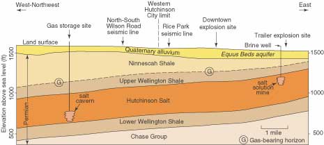
natural gas, or methane, appears to be a storage facility west of Hutchinson
(near a railroad-siding town named Yaggy). In the 1980’s, salt caverns
were created for storing propane in a layer of rock called the Hutchinson
Salt Member of the Wellington Formation, about 500 to 600 feet below ground.
These same salt beds are mined in Hutchinson and throughout central Kansas.
Salt caverns are effective for gas storage because gas can be quickly
introduced, and later removed. That’s especially useful during times
of peak demand, like cold winters. At Yaggy, the salt didn’t fail. But a pipe (one used to put gas
in and take gas out) did fail. For at least three days, highly pressurized
methane escaped through a hole in the pipe and moved up until it reached
a permeable zone near the contact between the Wellington Formation and
the overlying Ninnescah Shale. These rocks dip (or are angled) very slightly
to the west, and the pressurized gas moved up that dip until it found
a way to the surface. In Hutchinson, a town with a century’s history of salt mining,
that didn’t take long. Gas first exploded after it moved up an old
well that was used to produce mineralized water for a spa. The second
explosion occurred at the site of an abandoned well that was used to dissolve
and mine salt. Once the Yaggy leak was discovered, the cavern was emptied, cutting off
the source of the gas. That left methane under Hutchinson, though nobody
knew how much or where it was. The local utility, Kansas Gas Service, drilled wells to try to locate
the gas and flare it off. The first two, drilled where gas was expected,
came up empty. A few additional wells, put down mostly where the company
could gain quick access, found small amounts of gas, though most of these
vent wells were dry. Twelve days after the first explosion, the Survey’s shallow seismic reflection crew arrived in Hutchinson. The Survey’s crew specializes in very shallow (less than 1,000 feet deep) applications of seismic reflection. Gas Service wells were finding gas at depths between 420 and 250 feet.
Cross section of Reno County geology, showing the hypothetical movement of gas from a salt cavern to eastern Hutchinson. The seismic crew ran a four-mile-long line between Hutchinson and Yaggy, trying to create an image of the gas’s pathway. A second, much shorter line was run near a venting well in a city park. Survey scientists collected 60 gigabytes of data, enough to fill about 100 compact disks. After round-the-clock computer processing and interpretation, the Survey recommended that Kansas Gas Service drill two wells along one seismic line. Both hit gas. The Survey’s efforts involved more than seismic reflection, however.
After all this, Survey scientists theorize that the escaping gas may
have pushed along fractures in rocks above the salt, then flowed through
a thin bed of a limestone-like rock called dolomite. Layers of gypsum,
lying above the fractures, may have trapped the gas underground—like
bubbles of air under the ice on a pond—except in the places, such
as old wells, where gas found its way to the surface. That remains a theory. The Survey’s study of Hutchinson remains a work in progress. But one thing is clear: Years of developing geologic techniques and expertise, and decades worth of data and core samples, all became invaluable in an instant. And that same information may help prevent something similar from happening again.
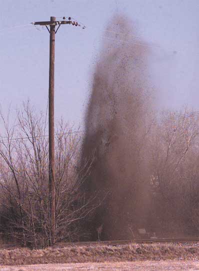
The largest of several gas and brine geysers spews dirt, water, and gas more than 30 feet in the air northwest of the Big Chief Mobile Home Park in Hutchinson, where a mobile home exploded January 18, 2001, killing two people. Photo by Sandra J. Milburn. Printed with permission of The Hutchinson News. |
| Online February 10, 2003 Comments to: lbrosius@kgs.ku.edu Kansas Geological Survey URL:http://www.kgs.ku.edu/Publications/GeoRecord/2001/vol7.2/Page1.html |