![]()
![]()
![]()
Prev--Pre-Meeting Field Trip 2 || Next--Post-meeting Field Trip 4
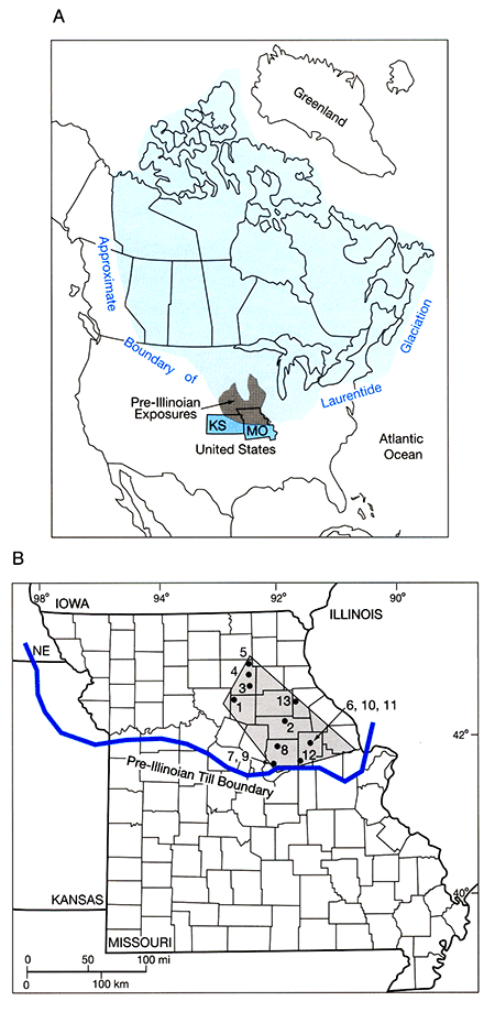
During a trip across the plains in 1868, Louis Agassiz realized that the presence of red boulders resting on gray limestone bedrock in northeastern Kansas constituted evidence of past glaciation. By 1881, less than 20 years after the American Civil War, Thomas C. Chamberlin was able to follow a glacial boundary from Massachusetts westward into Dakota Territory. He also recognized evidence for what he termed the "attenuated border" of an older glaciation. An 1885 map shows the extent of this earlier ice in northeastern Kansas and adjacent areas.
These earliest investigations developed the general framework of the glaciation of North America. It was established that Early Pleistocene ice sheets covered the northeastern corner of Kansas and most of the northern half of Missouri. Although several studies of local areas were undertaken at various times in the 1900's, no detailed regional syntheses have been forthcoming. There remains an abundance of unanswered fundamental questions.
Kansas terrain has notoriously low relief; Missouri is little better. Consequently, there are very few places where glacigenic sediments--till and outwash--can be viewed in natural exposures. Most information must be obtained from artificial displays that are usually very short-lived. During the 1950's and 1960's, numerous quarries were opened along the western side of the Missouri River valley to provide the Army Corps of Engineers with material for construction of jetties and levees. Everyone of those excavations exposed Pleistocene sediments, but all were soon abandoned and have been covered by vegetation and slumped debris.
In the 1960's and 1970's, several borrow pits were opened in and near Atchison to provide material for levees and small dams along and adjacent to White Clay Creek. All are now closed; most have been bulldozed to restore the original landscape. And in the 1970's and 1980's, extensive housing developments in the southwestern part of Topeka were accompanied by opening of excavations for water mains, sewer lines, street grades, and house foundations. These provided excellent, though very short lived, three-dimensional views of glacial deposits in and close to the terminal zone. All were quickly closed completely and essentially nothing of the subsurface relationships can be seen today.
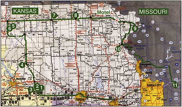
Because of limitations imposed by terrain and modern history, this field trip must be an unusually high-mileage event in order to visit exposures of tills and associated sediments even within Kansas. The route and locations of stops are shown in fig. 3-1. Because of severe time constraints during the initial running of this field trip in June 2004, some of the stops may be omitted. However, they are listed in this guidebook to provide references of possible use during future trips. A much greater distance has been added to provide opportunity to see unusual sections in east-central Missouri, as described by Rovey in Part II: Missouri.
Figure 3-1--Route map for the Kansas part of Field Trip 3. Black dashed line marks route of the Oregon Trail.
| 0.0 | West Lawrence toll booth entrance to the Kansas Turnpike. Go west. |
| 18.9 | Turnpike Exit 183. Continue west (straight ahead) on I-70 (fig. 3-1). Although the route lies well within the glaciated area, no evidence of this is visible, at least to the casual traveler on the highway. |
| 20.0 | Pay toll. |
| 24.2 | Passing through downtown Topeka; the State Capitol building can be seen to the left. Continuing westward, the Kansas River is visible on the right for a short distance. Roadcuts expose only Pennsylvanian bedrock, mostly limestone. |
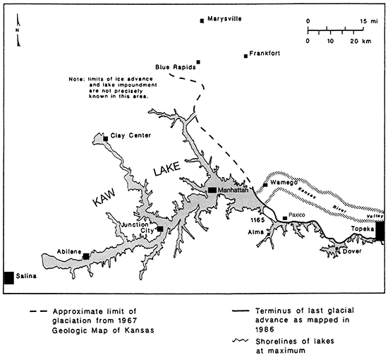
| 43.6 | The hilltop house south of the highway is situated almost exactly on the terminal line of glaciation in Kansas (as presently recognized). Large erratic boulders of Precambrian Sioux Quartzite are scattered through the pasture west of this house. The prominent hill directly ahead, known locally as Buffalo Mound, also lies on the glacial boundary. Ice butted against the northern (right-hand) slope, but did not cover the summit. The col south of the summit was briefly occupied by an ice marginal stream that connected proglacial lakes draining eastward (fig. 3-2). The horizontal lines of vegetation crossing the eastern face of the hill express stratigraphic control by limestone and shale units of Permian bedrock; they are not ice-marginal kame terraces. The Carboniferous (Pennsylvanian)-Permian contact is on the hillside on both sides of the road here. |
| 46.9 | The glacial boundary angles up from the southeast and here crosses the highway, which is oriented due west. |
| 48.3 | Another prominent hill ahead had ice butting against its northern side and an ice-marginal stream flowing through the col to the south. |
Figure 3-2--Proglacial lakes west of Topeka at the time of maximum ice advance. Shorelines depict water levels controlled by spillways against or close to the ice front. Location of the Kaw Lake spillway, elevation 1,165 ft (355 m), is shown. Drainage was eastward. It is believed that there has been no significant warping of the land surface since that time and that the glaciated terrain closely approximated the landscape of today, except for deposition in bayhead locations. This permits plotting on modern topographic maps.
| 50.4 | REST STOP |
| 53.5 | A few large boulders of Sioux Quartzite in the field directly north of the highway mark the glacial boundary at this point. Attempts at cosmogenic nuclide (Be-10) dating produced inconclusive results because there was so much spread from sample to sample. |
| 55.5 | Valley floor of Mill Creek. This lowland was occupied by a small proglacial lake. The impounding ice front was located a short distance north of the highway, probably with a tongue extending somewhat southward into the lake from time to time. |
| 57.2 | Mile Post 330. Exit from I-70.Sign says McFarland and Kansas Route 185. Go north (left) on gravel North McFarland Road(fig. 3-3). Opposite the first house on the right there are a few pink Sioux Quartzite boulders in the field that slopes up to the west. Their presence indicates that the glacial boundary has been crossed and the trip route has returned to glaciated terrain. The white and light-gray rocks are fragments of local limestone bedrock. Proceed northward uphill through a dissected landscape. Soil is thin; Permian bedrock lies close to the surface and is exposed in shallow draws. Pink Sioux Quartzite erratics are scattered across the landscape on both sides of the road. White boulders are fragments of the local limestone bedrock. |
| 61.0 | Intersection of North McFarland Road and Homestead Road on Tower Hill. |
Figure 3-3--Southwestern-most continental glaciation of North America, showing interpretation of younger and older limits, the shoreline of ice-impounded Kaw Lake, and its controlling easterly draining spillway. Locations of individual large Sioux Quartzite erratics are shown by triangles only where close to and defining the younger limit. Area shown is in Wabaunsee County south of Wamego and west of Topeka, Kansas.
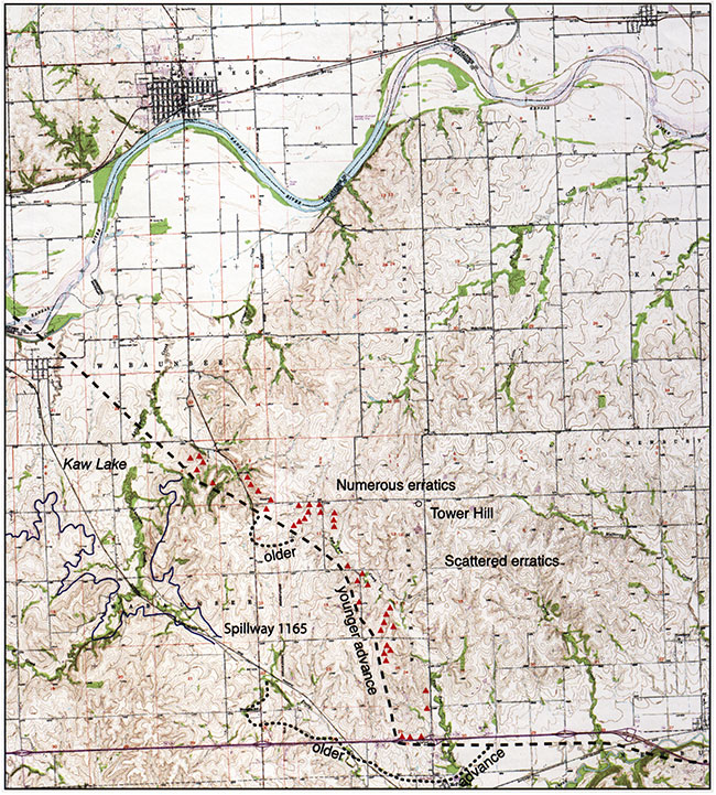
The flat summit of this hill is almost exactly 1,300 ft (396 m) above sea level. The Kansas River in its broad valley lies 6 mi (9.6 km) to the north at an elevation of 940 ft (287 m). Soil on this summit is very thin; Permian limestone bedrock is exposed in several places. Of greater significance are boulders of Sioux Quartzite. The presence of these erratics resting on ancient bedrock on the summit of the highest hill in the area provides proof that glacial ice surmounted this location. Looking toward the east and southeast one can identify large erratic boulders scattered across the landscape, and erratics were visible from the road as this Stop was approached. Although there is nothing visible here that could be called till, the erratics constitute clear evidence that glacial ice crossed the high divide of which Tower Hill is the culmination and continued almost 3 mi (4.8 km) farther south, reaching nearly to the line of highway I-70. However, because the limit line of the erratics bends toward the northwest, the boundary is only about 1 mi (1.6 km) southwest of this Stop (fig. 3-3).
Classical evidence that an area of low relief was formerly invaded by a continental ice sheet includes the presence of both erosional forms, especially smoothed and striated bedrock surfaces, and depositional materials--i,e., stratified outwash, unstratified diamicton (till), and, especially, far-traveled erratics.
In Kansas, glacially scoured bedrock surfaces are extremely rare, usually restricted to chance uncovering in quarries or along highways. Exposures of till are slightly more common, but most of these are created by artificial excavations and are quickly filled or collapse.
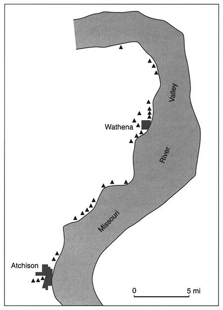
The best indicators of the former presence of glacial ice are erratics, up to large boulder size (fig. 3-4), that are prominently scattered across the countryside. In fact, the limits of former glaciation are most conveniently mapped in Kansas by charting the southernmost and westernmost extent of erratics. Most of the solitary erratic clasts are fragments of Sioux Quartzite, a tough Precambrian quartzite that is locally conglomeratic. Its color ranges through various shades of pink, making it easily recognizable at a distance and differentiable from local gray limestones. The Sioux is also present as pebbles and cobbles in most, but not all, till and outwash deposits. All Sioux erratics were derived from a closely delineated outcrop area that is restricted to southern Minnesota and small adjacent areas in southeastern South Dakota and extreme northwestern Iowa (fig. 3-5).
Figure 3-4--Sioux Quartzite boulder 2 mi (3.2 km) northwest of Dover, Kansas.
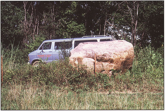
Figure 3-5--Sources of identifiable glacial erratics found in northeastern Kansas. Fragments of Sioux Quartzite are common throughout the terminal zone, and eastward into Missouri. Specimens of ore from the Iron Ranges are scarce. Distribution of Lake Superior agates from the Keweenawan volcanics is highly localized, seemingly restricted to an area in and near Topeka.
Common in a specific few exposures are clasts of various igneous and metamorphic rocks eroded from sources in far northern United States or in Canada. Included are many varieties of granitic rocks, plus metavolcanics and exotics such as Lake Superior agate, Duluth area iron ore, and Keweenaw volcanics and native copper. Present only rarely are small pieces of the soft Pipestone variety of the Sioux Formation. Many exposures display remarkable concentrations of a single clast lithology. Most common are those showing ca. 95% to as high as 100% Sioux Quartzite. In sharp contrast are deposits composed almost entirely of granitic boulders or of various-sized fragments of local limestones.
Field mapping indicates that the southern and southwestern limits of ice advance are very sharply expressed. Throughout most of the distance from Kansas City westward through Topeka and Wamego, and northward toward Nebraska, there is an abrupt edge to the Sioux Quartzite erratics. This permits plotting of a very precise boundary.
It is readily observable that far-traveled erratics, whether contained in till or outwash, or scattered about as solitary boulders, cannot easily be found throughout the entire area of Kansas that is believed to have been covered by continental ice sheets. Instead, in most parts of this area, it is notably difficult to find any evidence whatsoever of the former presence of glacial ice. Indeed, one can drive for miles past roadcut exposures on major highways and observe only bedrock capped by thin soil. This sparseness of ice-deposited debris led Chamberlin (1895) to speak of the "attenuated border" of glaciation, a term that was subsequently adopted by Schoewe (1938). Ongoing discussions have debated whether this situation is a product of original glacial deposition or later modification.
In marked contrast, till, outwash, and erratics are common along the terminal zone of glaciation. Indeed, there is such a close coincidence of the southernmost evidence of the former activity of glacial ice and the presence of concentrations of these glacial deposits that one is tempted to engage in circular reasoning. If numerous erratics are present, the locality must be in the terminal zone--or--if this place is in the terminal zone, till and erratics should be commonplace. Nevertheless, observed facts frequently, though not always, uphold this conclusion.
Following a transect southward from the NebraskaKansas border, glacial deposits are present though sparse, abruptly become thick and widespread, then are found no more. It seems indisputable that the ice advanced no farther and that melting along an essentially stable glacier front yielded an accumulation of englacial and supraglacial debris brought from northern sources.
At a very few localities situated well north of the terminal zone, there are limited occurrences of thick, erratic-rich till, generally exposed in small gravel pits or quarries. These deposits have been informally identified by several field geologists as remnants of recessional moraines. In addition, at least three "outliers" of glacial debris, including Sioux Quartzite clasts, have been found 3-6 mi (4.8-9.6 m) south of "the glacial boundary," thus well outside of the supposed limit of ice extent. No clear explanations have yet been determined.
This locality has been the scene of vigorous debates regarding the extent and accomplishments of post-glacial erosion in Kansas. Opposing end-member conclusions are outlined below:
Compilation of field observations indicates that Conclusion 2 is close to the truth. For one thing, a thick section of till deposited on an ancestral Tower Hill would surely have contained numerous rock fragments up to boulder size. A high percentage of these would have been composed of tough Sioux Quartzite, as is seen in existing exposures of till at other localities, some close nearby, such as at Stop 2. As erosion attacked such a deposit, the finer fragments would have been moved down the gentle summit slopes by gravity and rainwash. The larger clasts would have become differentially concentrated more or less in place for a while, but ultimately even these would have moved downslope. Chemically weaker granitic rocks might succumb to weathering, but the resistant quartzite would be little affected.
The expected end result would be that all stream courses, from fingertip rills to larger creeks, would have become choked with a lag concentrate of fragments of Sioux Quartzite. However, such a situation is not found in the field other than at a few limited occurrences where thick till is present today. Most valleys, of all sizes, are entirely free of erratics. This argues for non-deposition of till over much (most?) of the glaciated area, and that, in tum, bears glaciological and climate implications.
Equally strong support for a proposal that post-glacial erosion was ineffective is provided by examination of the relationship between the line connecting the southernmost occurrences of glacial erratics and local topographic features. Detailed mapping demonstrates that there is no consistent link, no topographic control in situations where it would be most expected. Especially noteworthy are places where the drift border crosses a ridge at an angle to the linear crest, but the ridge causes no deviation in the line of most southerly erratics (fig. 3-3). If postglacial erosion had been effective, downslope movement of glacial debris would have at the very least smeared the terminal line and more likely completely cleaned off the slope.
| Proceed west on Homestead Road. |
| Sioux Quartzite erratics are especially numerous to the right (north). |
A small fingertip stream system draining the western side of Tower Hill is shallowly incised. Unlike other drainageways in the area, this valley exposes bouldery till resting on limestone bedrock. On the northern side of the road, the thickness is about 15 ft (4.6 m); south of the road, a short distance to the west, a limestone cliff has only a thin cover of till. At both locations in excess of 99% of the large clasts are Sioux Quartzite. Only one granite boulder, 3 ft (0.9 m) long, has been found. Smaller clasts, mainly pebble size, include other lithologies, yet still are about 99% Sioux Quartzite. It is of interest that the non-quartzite clasts exhibit no megascopic evidence of weathering, even though lying unprotected on the surface of the ground. Although it is expected that the resistant Sioux Quartzite might not have been affected by chemical or mechanical weathering, it is puzzling to find granite clasts that appear fresh and untouched. It is especially difficult to explain the preservation in the till of well-striated limestone boulders.
The pattern of associated bedrock exposures indicates that the till here is basically confined to a small pre-glacial valley that has been partially re-excavated by the modern stream. The waterways here are choked with Sioux erratics, providing evidence that till has been removed from the slopes by erosion and transported into the nearest channels. As was discussed above, this is what would be expected everywhere if thick, widespread till had been eroded in the past. Because no such concentrations of erratics are generally found, it is believed that thick till deposits were spatially very limited.
| Continue west on Homestead Road. |
The frequency of Sioux Quartzite erratics decreases and the average size becomes smaller. A few erratics are visible in roadside ditches and nearby fields for a distance of about I mi. Then no more are seen. The interpretation is that the straight road has crossed the terminal limit of glaciation that is here oriented southeast-northwest (see fig. 3-3). That of course would mean that the route has entered the unglaciated area.
However....
| 63.1 | Turn left (south) on new gravel driveway. |
Excavation of the foundation for a new house was undertaken on about April 15, 2004. Preliminary observations indicate that the subsurface material is a weathered till that contains ghosts of rotten granite, a few fragments of Sioux Quartzite, pebbles of various other lithologies, and very numerous small, angular bits of chert. Initial, spur-of-the-moment interpretation is that this is a previously unseen and unsuspected till that is distinctly older than and out in front of the till that contains the numerous large Sioux Quartzite boulders that are seen here scattered across the landscape. It would therefore be a record of a distinctly older advance of the ice sheet.
Three miles (4.8 km) due south of this new excavation there is an old, very shallow cut beside a dirt road (figs. 3-3 and 3-6). This cut exposes a limestone pebble gravel that contains only a few small Sioux Quartzite clasts. This occurrence is enigmatic. The presence of the Sioux pebbles requires some association with glacial activity, but its location well outside of the supposed glacial limit defied ready explanation. Discovery of the old "outside-the-limit" till in the new house excavation suggests that there is some connection; even though one exposure is highly weathered. the other is not. Further investigation, particularly between these two "old" exposures, may produce an explanation.
Through many years of exploring glacial deposits in Kansas, it has always been believed that the most southerly boulder of Sioux Quartzite along any specific line of ice flow marked the limit of southward advance of the continental glacier at that point. Indeed, it became an article of faith that the east-west line connecting adjacent, closely spaced, most-southerly boulders clearly delineated the ice front at the time of maximum advance. This postulation appears to be sound-but only within limits. It omits the possibility that multiple advances of the ice sheet could produce a more complex record, and almost surely would have done so.
It seems certain that a single, specific glacial advance deposited the numerous, large Sioux Quartzite boulders that collectively compose what has herein been called the terminal zone. The southerly margin of this zone has been identified as the limit of glaciation. At the same time, a very few scattered occurrences of debris of apparent glacial origin were known to exist farther south--outside the limit of glaciation. Something was wrong!
The presence of a small exposure of erratic-bearing gravel 3 mi (4.8 km) south of the Tower Hill limit of glaciation was recorded some years ago--and was essentially ignored in a decidedly unscientific fashion. The discovery of a weathered, fine-grained till in the new house excavation at Stop 3 provided the necessary clue. The current interpretation is that this is a separate till body that predates the big-boulder till seen at Stop 2 and extends farther south--beyond the limit of glaciation as defined by the large Sioux Quartzite boulders. Thus, this is taken as evidence of a new, hitherto unrecognized glaciation.
Perusal of a recently published soil report for Wabaunsee County (Graber et al., 1991) finds that the USDA soil scientists identified and mapped areas underlain by the Pawnee Soil, which is defined as having developed on glacial till and outwash. Some of these areas extend from Tower Hill south to I-70 and beyond, all the way to the town of McFarland (fig. 3-6).
Figure 3-6--Distribution of the Pawnee Soil in the Tower Hill-McFarland area as shown in the Wabaunsee County Soil Survey report. By definition, the Pawnee Soil developed by weathering of glacial sediments. Its presence identifies similar substrate but not necessarily constant age. The Pawnee Soil extends significantly outside the limit of prominent Sioux Quartzite boulders, only the farthest southwest of which are shown here (see fig. 3-3).
On the basis of these discoveries, it appears that in the Tower Hill/McFarland area there are present patches of tills of two distinct ages, tills that were deposited by two separate advances of continental ice. Furthermore, these tills appear to be the products of contrasting glacial erosion and transportation regimes, one leaving numerous large boulders, the other very few. And their episodes of aggradation were separated by a period of time long enough to permit considerable weathering of the first deposit prior to superimposition of the second.
| Return to Homestead Road. | |
| 63.5 | Continue west on Homestead Road. |
| 63.9 | Another new house excavation on the southern side of the road exposes limestone and shale overlain by a ferruginous soil, probably a paleosol, and a sparse scattering of pebbles of erratic lithologies. In terms of the regional pattern, the terminal line was oriented approximately east-west subparallel to I-70 westward from Topeka to almost exactly the point where this field trip turned north on North McFarland Road. From that point the glacial boundary extends northwestwards to the Kansas River, thence northwards into Nebraska. That point of change in orientation is the point of farthest southwestward advance of continental ice in North America (fig. 3-7). |
| 64.0 | Turn right (north) on Kansas Highway 99. |
| 64.7 | The highway skirts the western side of a narrow, steep-sided ridge. Limestone bedrock crops out about halfway up the sideslope, but the crest is covered by a felsenmeer of small, rounded Sioux Quartzite boulders (fig. 3-8). Levelling indicates that this cap may be as much as 33 ft (10m) thick. The nearly flat summit of the ridge may be the original end-of-deposition surface. Although somewhat similar concentrations of Sioux erratics occur in a few other places along the terminal zone, this occurrence is particularly outstanding. The boulders are so numerous as to be in contact with one another. If this situation extends into the subsurface, then the deposit is a clast-supported boulder gravel. The clasts are all Sioux Quartzite, all are subrounded to rounded, and there is a distinctly limited size range; almost all are between 6 and 20 inches (15-50 cm) long. |
The high degree of sorting of rounded boulders makes this some sort of outwash deposit rather than a typical till. Indeed, at least one observer has proposed that this is a glacial flood gravel. However, this gravel caps a narrow ridge that lies almost precisely on the line of farthest advance of the ice sheet. The terminal line can be traced from the southwestern flank of Tower Hill to this ridge and then diagonally across the valley and the ridge to the northwest.
This gravel cap is, therefore, a terminus feature on a preglacial high. Furthermore, the apparent high degree of size sorting does not, in this case, require selectivity by running water. Outcrops of Sioux Quartzite in the Minnesota source area locally expose strata that are riven by joints spaced 12 to 18 inches (30-45 cm) apart and intersecting at right angles, providing a ready source for a field of boulders all about the same size. This explanation does, however, require transport en masse from southern Minnesota to northern Kansas, a phenomenon for which there is supporting evidence elsewhere along the terminal zone but which suggests puzzling ice mechanics.
| Continue north on Kansas Highway 99. |
The route crosses a prominent remnant of a high terrace of the Kansas River, then the broad valley floor and the river itself.
At the time of maximum glacial advance, the valley of the Kansas River was covered by the continental ice sheet all the way east to Kansas City, a straight line distance of 92 mi (147 km), but 127 (203 km) mi by today's river channel. The western limit of glaciation is approximately 4 mi (6.4 km) upvalley from Wamego. In order for the glacier to flow southward across the river valley and still be able to surmount Tower Hill, 360 ft (110 m) above the present floodplain, there must have been a continued pressure gradient toward the south and the surface of the ice undoubtedly maintained a southward topographic gradient. Without considering other factors, one can crudely estimate that the ice must have been at least 300 ft (91 m) thick on the upland north of the river and perhaps 500 ft (152 m) thick over the ancestral valley of the Kansas River.
Figure 3-7--Extent of pre-Wisconsinan ice sheets in central United States. Note the location of Tower Hill at the southwestern-most limit of glaciation.
Glacial ice effectively blocked flow of the ancestral Kansas River, impounding a lake to the west of the ice front (fig. 3-2). Because water continued to reach this area from the upstream drainage basin, the water level would have risen until it reached the elevation of some low point in the topographic divide on the southerly side. Overflow across a spillway would then permit drainage to continue to lower elevations toward the east. This critical low point, with a threshold elevation of 1,165 ft (355 m), is located just west of Kansas Highway 99 about 2 mi (3,2 km) south of the Tower Hill road (fig. 3-3). Until a few years ago a railroad track used this low point as a means of exit southward from the Kansas River valley.
The former existence of this glacier-dammed lake was recognized by Hay (1893) and named Kaw Lake by Smyth (1898). At its maximum it extended westward at least 70 mi (112 km) in the Kansas River valley as well as up the valleys of the Big Blue and Republican rivers. The locations of the present towns of Manhattan, Junction City, Abilene, Clay Center, and perhaps Salina were all lakefront properties.
The spillway that controlled the level of Kaw Lake, as well as the spillways holding smaller lakes in lower tributary valleys farther east, the cols seen along I-70 Highway, show no signs of the passage of prolonged, high-volume flow. No channel incision is apparent; that suggests that only small volumes of water escaped from Kaw Lake by this route, and only for a short period of time. A consequential implication is that the ice front remained in its terminal position for only a brief interval.
Even a casual glance at a map of the North American interior clearly shows that at the time of maximum advance of the continental glacier into Kansas and adjacent states, there still remained a large part of the drainage basin of the Missouri River that was ice free. Precipitation falling on that area had to flow around the margin of the ice. Considerable volumes of water, at times, must have been augmented by meltwater from a receding glacier. The Kaw Lake spillway and overflow cols to the eastward did not have the capacity necessary for discharges of the requisite magnitude. The water must therefore have gone elsewhere.
The present floodplain of the Kansas River overlies alluvial fill as much as about 190 ft (58 km) thick at Kansas City and several tens of feet thick upstream. Thus, there is a deep, wide bedrock valley and a narrow inner gorge now concealed beneath younger sediment. There is the possibility that high-volume stream discharge followed a sub-glacial tunnel eastward to Missouri. Such an occurrence was considered an impossibility only a few years ago, but streamflow in tunnels beneath glaciers, resulting in the carving of subice tunnel valleys is now being proposed for many localities in North America and Europe. Even so, it does not appear reasonable to suppose that a large stream could maintain tunnel flow for a distance of almost 100 mi (160 km) beneath an active ice sheet. A better explanation might be that the glacier front did not extend south of the Kansas River valley for more than a few years.
Figure 3-8--Sea of erratics on ridge crest 5 mi (8 km) south of Wamego. More than 99% of these clasts, displaying a remarkably small range in size, are composed of Sioux Quartzite.

| 70.3 | Pass through downtown Wamego. |
| 71.0 | Continue north to U.S. Route 24. Turn right (east) one block. REST STOP at McDonald's. Leaving McDonald's, turn left (west) one block, then right (north). Continue north on Kansas Highway 99. |
| 74.3 | Pass through edge of town of Louisville. |
| 80.0 | The route joins the line of the Oregon-California Trail (see fig. 3-1). |
| 85.1 | A major campground on the Oregon-California Trail occupied all of the lowland directly ahead. Water was secured from nearby springs. |
| 85.7 | Town of Westmoreland.
Turn west (left) on the first street (State Street). Note Sioux Quartzite boulders in house yards and beside the road. Continue west through several stop signs, eventually joining a highway. |
| 86.9 | Drive into Highway Department storage yard on the southern side of the highway. |
The presence of small boulders of Sioux Quartzite in house yards is not proof that the area has been glaciated. This is an attractive ornamental rock that is often transported considerable distances for purely decorative uses. However, visible from this stop are several large Sioux boulders lying in the field to the south. Almost surely these lie where they were left by the melting glacier (except where they have been moved by presently active construction of new houses). Therefore, the terminal boundary must be located farther to the west (10 mi [16 km] according to the Geologic Map of Kansas [Kansas Geological Survey, 1991]). The route northward from Wamego was entirely within the area of glaciation, but no till or erratics were visible.
| Return eastward through downtown Westmoreland to Kansas Highway 99. | |
| 88.2 | Turn left and continue northward on Kansas Highway 99.
The route passes through a highly dissected terrain cut in Permian limestones. This is, in essence, a northern extension of the Flint Hills. The area has been glaciated, but no evidence of the former presence of ice is visible from the road. It is especially noteworthy that none of the draws are choked with Sioux Quartzite boulders, as would be expected if a thick cover of till had been largely removed by postglacial erosion. |
| 110.1 | Town of Frankfort. |
| Turn left (west) on Kansas Highway 9. | |
| 122.6 | Turn right (north) on U.S. Highway 77. |
| 129.5 | Turn right (east) on gravel Osage Road. |
| 130.1 | Turn right (south) into borrow pit. |
This excavation, which has been active for several years, is a source of sand and gravel for the Marshall County road and public works department. Exposed is a jumble of pebble to small boulder gravel plus a small quantity of actual till. Most of the clasts are granitic, some weathered to grus ghosts. Also present are fragments of dark igneous and metamorphic rocks, but only a few of Sioux Quartzite. Interpretation of this site must be combined with that for the closely adjacent next Stop.
| Return to U.S. Highway 77. | |
| 130.9 | Turn right (north) on U.S. Highway 77. |
| 131.1 | Turn right (east) on quarry access road. |
This excavation is a private commercial operation. However, the sediment deposit is a continuation of that seen in the County pit at Stop 5 and the two must be considered as a single entity.
The suite of clasts exposed here contains the same general distribution of lithologies as is seen in the County pit. Sioux Quartzite is scarce. The prevalence of small- to medium-sized boulders provides evidence of a vigorous stream, the northern margin of which has been exposed as an irregular, nearly vertical bedrock cliff that effectively limited quarry development. Foreset bedding indicates flow toward the east, a surprising direction because that is toward the interior of the glacier. Additional spatial information is needed for further interpretation.
| Return to U.S. Highway 77. Turn right (north). | |
| 135.6 | Marysville. Turn right (east) on U.S. Highway 36 |
| 167.1 | Passing the town of Seneca. |
| 168.3 | Turn right (south) on Kansas Highway 63. |
| 168.9 | Turn right into borrow pit. |
This small borrow pit exposes a type of till not seen at any of the preceding stops. It has a clay matrix and contains very few clasts larger than pebble size. Casual search finds no Sioux Quartzite, though at least a few fragments are probably present. Oxidation has produced tan iron-staining in the upper part of the section, an effect that has penetrated more deeply along cracks in the original gray portion.
The Midwest Friends of the Pleistocene field trip in June 2000 stopped at this locality. Its guidebook states that when examined in 1999 the excavation face exposed two "matrix-dominated loamy diamictons with inclusions of deformed sand and gravel," heavily jointed, and oxidized in the upper part (Mandel and Bettis, 2000). Till diapirs in deformed stratified sediments suggested ice movement from the northeast. The 2000 guidebook correlates these two diamictons with the upper and lower tills of the Independence Formation as has been proposed by Aber from exposures west of Atchison. In a personal communication in 2004, Rovey suggested that these are the A and B tills of Boellstorf.
| Return to U.S. Highway 36. | |
| 169.7 | Continue east on U.S. Highway 36.
Decorative boulders of Sioux Quartzite in house yards may have been brought in from nearby sources. |
| 183.5 | REST STOP. |
| Proceed north on U.S. Highway 75. | |
| 186.5 | Turn right (east) on dirt road. |
| 186.7 | Turn right into borrow pit. |
This small borrow pit has been sporadically active for several years. Subsurface relationships must be complex; details of the exposure have changed frequently as excavation continued. In the past, a generalized description reported the presence of silty colluvium overlying fine-grained till in the upper part of which is a weathering zone believed to be the Sangamon Paleosol. A very few Sioux Quartzite boulders are present. Most noteworthy is a localized concentration of generally elongated, white caliche nodules scattered along fractures in the till. This phenomenon has been observed at only three other localities in northeastern Kansas and northwestern Missouri. Its significance is unknown.
| Return to U.S. Highway 75. Turn left (south). | |
| 190.2 | Turn left (east) on U.S. Highway 36. |
| 193.5 | Passing through Fairview. |
| 204.6 | Exit to U.S. Highways 73/159 north. |
| 205.1 | NIGHT STOP. Hiawatha Inn. |
| 0.0 | Depart Hiawatha Inn.
Proceed south to U.S. Highway 36. Turn left (east) on U.S. Highway 36. |
| 33.3 | Enter Wathena. Turn right (south) on 4th Street.
Bend right to cross bridge and railroad. Bend left and proceed south on Monument Street (also known as the River Road). Enter the floodplain of the Missouri River and follow the base of the valleyside bluff. |
An eroded, overgrown roadway leads to a long-abandoned borrow pit, source of sand, gravel, and fill-dirt in the late 1960's. To the left (south) there is a large face nearly 140 ft (43 m) high, having north-south orientation, that displays interbedded and deformed till and glaciofluvial sand. To the right (north), and completely separate, there was an excavated east-west face about 38 ft (12 m) high. As of early 2004, this had completely collapsed and was further obscured by trees and brush. An attempt will be made to re-excavate this site before the field trip.
This small pit is known colloquially as the Sudi site because it was the subject of a 1971 Master's thesis by Sudi Einsohn (since deceased). It was more formally referred to as the Wathena South Pit No.1 (Bayne, 1968) even though, as Einsohn (1971) noted, it was not the first pit south of Wathena, nor was it the first to be excavated. Nevertheless, its uniqueness gives it considerable geological importance.
As far as is known, this is the only North American location where faunal remains have been found stratigraphically beneath a pre-Illinoian till (fig. 3-9). Designated the Wathena Local Fauna by Martin and Schultz (1985), the assemblage includes 14 species of fish, a salamander, two species of turtles, four waterfowl and a towhee, plus 12 species of shrews, ground squirrels, mice, muskrats, lemmings, and voles. Accumulation in a fluctuating, swampy pond environment, perhaps an abandoned river channel, was suggested.
At the time the thesis was being written in 1970, assignment of an age to this fauna was difficult. According to information then current, several of the species present were believed to be of Late Kansan or even post-Kansan (Yarmouthian) age; two were assigned to the Illinoian! But the fauna occurred beneath a till-and conventional wisdom demanded that no till present in Kansas could be younger than the then-accepted Kansan Glaciation.
In 1985 Martin and Schultz included the Wathena Local Fauna in the Sappan, a subprovincial age within the Irvingtonian. They stated that the Sappan faunas in Kansas are post-Blancan, but pre-Kansan. They also reported that the type Sappa Local Fauna in Nebraska occurred beneath a volcanic ash that had been dated at 1.20 my B.P.
About the best that could be said was that the fauna present at the Sudi site lived sometime before some advance of glacial ice into northeastern Kansas and that that advance was most probably part of what has in the past been called the Kansan Glaciation, although the location lies within the area previously believed to have been covered by the preceding Nebraskan Glaciation. (The terms Kansan and Nebraskan are now in disrepute.)
In a 1988 publication (Aber, 1998a), repeated in 1991, Aber presented a measured section attributed to a "gravel pit south of Wathena" and referred to Einsohn's work. He called attention to the presence of the Wathena local fauna at the base of the diagrammed exposure. In support of scientific integrity, attention must be directed to the fact that this diagram appears to be erroneous.
The diagram shows the 140-ft (43-m)-high face of the southern excavation. This is not the location of the Wathena Local Fauna. The faunal assemblage was present at the smaller Sudi site, which is situated entirely separate from and about 300 ft (92 m) north of the large face. As pointed out in Einsohn's thesis (1971), there was no similarity in the stratigraphy of the two pits and cross correlation was impossible. Einsohn specifically stated that "no vertebrate remains were found in any of these new exposures (the large, high face south of the Sudi site). The Wathena South No. 1 pit is the only Pleistocene exposure in northeastern Kansas in which vertebrate remains have been reported" (Einsohn, 1971, p. 34).
The once spectacular high face of the pit adjacent to and south of the Sudi site is now badly slumped. However, the upper part still reveals some of the deformed interbeds of both sand within till and till within sand. When freshly exposed, the most noteworthy features were sharply bounded, angular blocks of well-stratified sand diversely oriented and encased by till. These were outstanding examples of frigites, blocks of sand that maintained their identity and shape during transportation because the loose sediment was frozen and acted as a solid. It is clear that this assemblage was deposited in a highly dynamic ice-front environment. Limestone boulders are prominent in the till, as well as clasts of igneous and metamorphic rocks.
Figure 3-9--Diagram of the Sudi site stratigraphy copied from Einsohn's 1971 Master's thesis (Einsohn, 1971).
| Return northward to Wathena. | |
| 34.9 | Turn left (west) on U.S. Highway 36. |
| 43.5 | Exit to Kansas Highway 7 and proceed southward.
Follow Highway 7 into the outskirts of Atchison. |
| 62.9 | Turn right (west) at sign that says "To South 59." Then veer left. |
| 63.8 | Junction U.S. Highway 59. Turn right (west). |
| 63.7 | Turn sharp left (south) at sign that says "To South 59."
At this junction. note the exposure straight ahead. |
| 65.1 | Turn left (south) on Ottawa Road. |
| Turn left again into private driveway. | |
Although not a large stream, White Clay Creek, as a consequence of its flashy flow regime and displacement against its southern bank by both natural and artificial forces, has accomplished disproportionately great erosion. The result has been creation of the high cutbanks seen here and at the highway junction a mile and a half (2.4 km) east, as well as several smaller faces. These expose spectacular sections of till and glaciofluvial sand and gravel that have attracted the attention of geologists since the early 1900 's.
Schoewe (1938) described the presence of two distinct tills here but was uncertain whether or not the lower till was of Nebraskan age. This observation was repeated and extended by Frye (1941), who regarded the lower till as being a product of the Nebraskan Glaciation. This conclusion was repeated, though with less detail and certainty, by Frye and Leonard (1952). It was accepted by Dort as a working hypothesis during the 1960's and 1970's. In 1973 Ward reported the presence of Nebraskan(?) till in the subsurface but not exposed. Dellwig and Baldwin (1965), when analyzing deformation of the two tills and intervening sands, accepted a Nebraskan(?) age for the lower till.
In a paper presented at a meeting in 1982, but not published until later, Aber (1985) discussed the exposure seen at this Stop. (He diagrammed this exposure in this and other papers. See fig. 3-10.) He unequivocally stated that the lower till is of Lower Kansan age and the upper till is of Upper Kansan age. correlating them respectively with the Nickerson Till and the Cedar Bluffs Till of Reed and Dreeszen (1965) in Nebraska. He did not, however, provide clear evidence or reasoning for thus discarding a Nebraskan age for the lower till. In an abstract, Aber (1986) proposed that the Nebraskan should be "demoted" to become "the first substage of the Kansan."
In subsequent publications, Aber lumped all of the strata--lower till, sand and gravel, upper till--into a newly named Independence formation, which then became the type section for all deposits of the Kansan Glaciation. By 1991 he placed on a map the "Early Independence Glacial Limit" and the "Late Independence Glacial Limit" (Aber, 1991). These mimicked the Nebraskan and Kansan limits of previous authors. The result appears to be a grouping of all glacial and glacially related deposits in the state of Kansas into a single unit--the Independence formation, and ignores information from other exposures situated along the Missouri River bluffs north of Atchison (fig. 3-11).
Figure 3-10--Measured sections of the exposure at Stop 10 as drawn by Aber in (A) 1988b, (B) 1985, and (C) 1985. Variations may be due to changes in the plane of viewing or in modifications in interpretation. Aber has designated the entire sequence as the type section of his Independence formation, coeval with the Kansas Glaciation.
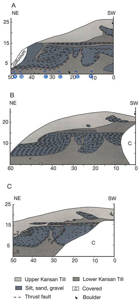
Figure 3-11--Some of the quarries and pits that could provide information about Pleistocene deposits along the western side of the Missouri River valley in northeastern Kansas.
Aber, J. S., 1982. Two-ice-lobe model for Kansan Glaciation: Nebraska Academy of Sciences. Transactions v, 10, p. 25-29.
Aber, J. S., 1984. History of Kansas glacial geology: Earth Sciences History, v. 3, p. 134-142.
Aber, J. S., 1985. Definition and model for Kansan Glaciation: TER-QUA Symposium Series, v, I, p. 53-60.
Aber, J. S., 1986, Stratigraphy of Kansan and Nebraskan tills west of Missouri River (abs.): Kansas Academy of Science, Abstract Volume, p. I.
Aber, J. S., 1988a, The glaciation of Kansas: Heritage of the Great Plains, v. 21, no. 4, 36 p.
Aber, J. S., 1988b, West Atchison drift section: Geological Society of America, Centennial Field Guide, South-central Section, v. 4, p. 5-10.
Aber, J. S., 1989, Catastrophic glacial-lake flooding in northeastern Kansas (abs.): Kansas Academy of Science, Abstract Volume, p. I.
Aber, J. S., 1991, The glaciation of northeastern Kansas: Boreas, v. 20, no. 4,p. 297-314.
Aber, J. S., Abdelsaheb, L., Nutter, B, Denne, J. E., and Macdonald, W. D., 1988, Composition, paleomagnetism, and age of the Kansas drift (abs.): Kansas Academy of Science, Abstract Volume, p. I.
Bayne, C K., 1968, Evidence for multiple stades in the Lower Pleistocene of Northeastern Kansas: Kansas Academy of Science, Transactions, v, 71, p. 340-349.
Bayne, C. K., Davis, S. N., Howe, W. B., and O'Connor, H. G., 1971, Regional Pleistocene stratigraphy: Kansas Geological Survey, Special Distribution Publication, v. 53, p. 4-8.
Boellstorf, J., 1978a, A need for redefinition of North American Pleistocene stages: Transactions of the Gulf Coast Association of Geological Societies, v. 28, p. 65-74.
Boellstorf, J., 1978b, Chronology of some Late Cenozoic deposits from the central United States and the ice ages: Transactions of the Nebraska Academy of Science, v. 6, p. 35-49.
Chamberlin, T. C., 1895, The classification of American glacial deposits: Journal of Geology, v. 3, p. 270-277.
Dellwig, L. F, and Baldwin, A. D., 1965, Ice-push deformation in northeastern Kansas: Kansas Geological Survey, Bulletin 175, part 2,16 p.
Dort, W., 1966, Nebraskan and Kansan stades--Complexity and importance: Science, v. 154, p. 771-772.
Dort, W., 1985, Field evidence for more than two early Pleistocene glaciations in the Central Plains: TER-QUA Symposium Series, v. I, p. 41-51.
Dort, W., 1987, Salient aspects of the terminal zone of continental glaciation in Kansas; in, Quaternary Environments of Kansas, W. C. Johnson, ed.: Kansas Geological Survey, Guidebook Series, n. 5, p. 55-56.
Einsohn, S. D., 1971, The stratigraphy and fauna of a Pleistocene outcrop in Doniphan County, northeastern Kansas: Unpublished Master's thesis. University of Kansas, 83 p.
Frye, J. C., 1941, Reconnaissance of ground-water resources in Atchison County, Kansas: Kansas Geological Survey, Bulletin 38, part 9, p. 237-260.
Frye, J. C. and Leonard, A. B., 1952, Pleistocene geology of Kansas: Kansas Geological Survey, Bulletin 99, 230 p.
Graber, S. P., Campbell, H. v., and Tricks, B. D., 1991, Soil survey of Wabaunsee County, Kansas: U.S. Department of Agriculture, Soil Conservation Service, 132 p. + maps.
Hay, R., 1893, Some characteristics of the glaciated area of northeastern Kansas: Kansas Academy of Science, Transactions, v. 13, p. 104-106.
Kansas Geological Survey, 1991, Geologic map of Kansas; digital compilation by J. G. Ross et al.: Kansas Geological Survey, M-23, scale 1:500,000.
Mandel, R. D., and Bettis, E. A., 2000, Late Quaternary landscape evolution in the South Fork Big Nemaha River valley, southeastern Nebraska and northeastern Kansas: Midwest Friends of the Pleistocene, 47th Field Conference, Guidebook II, Nebraska Conservation and Survey Division, 105 p.
Martin, L. D., and Schultz, C. B., 1985, Small mammals of the Seneca and Sappa local faunas (post-Ogallala of Nebraska): TER-QUA Symposium Series, v. 1, p. 163-179.
Mudge, M. R., 1955, Early Pleistocene geomorphic history of Wabaunsee, southeastern Riley, and southern Pottawatomie counties, Kansas: Kansas Academy of Science, Transactions, v. 58, p. 271-281.
Mudge, M. R., and Burton, R. H., 1959, Geology of Wabaunsee County, Kansas: U.S. Geological Survey, Bulletin 1068, 207 p.
Reed, E. C., and Dreeszen, V. H., 1965, Revision of the classification of the Pleistocene deposits of Nebraska: Nebraska Geological Survey, Bulletin 23, 65 p.
Schoewe, W. H., 1938, The West Atchison glacial section: Kansas Academy of Science, Transactions, v. 41, p. 227.
Smyth, B. B., 1898, The buried moraine of the Shunganunga: Kansas Academy of Science, Transactions, v, 15, p. 95-104.
Todd, I. E., 1909, Drainage of the Kansas ice sheet: Kansas Academy of Science, Transactions, v. 22, p. 107-112.
Todd, I. E., 1911, History of Wakarusa Creek: Kansas Academy of Science, Transactions, v. 24, p. 211-218.
Todd, I. E., 1918a. Kansas during the Ice Age: Kansas Academy of Science, Transactions, v, 28, p. 33-47.
Todd, I. E., 1918b, Lacustrine beds near Atchison (abs.): Kansas Academy of Science, Transactions, v. 29, p. 116-117.
Ward, J. R., 1973. Geohydrology of Atchison County, northeastern Kansas: U.S. Geological Survey, Hydrologic Investigations Atlas HA-467, 2 sheets.
At the intersection of I-70 and State Highway 54 at Kingdom City, Missouri, turn north onto Highway 54 and proceed about 0.4 mi (0.6 km) to the outer or north frontage road. Turn right (east) onto the north frontage road, drive for approximately 3.5 mi (5.6 km), and turn left (north). Follow this gravel road north for slightly more than 0.5 mi (0.8 km) to where the road jogs west for approximately 100 ft (30 m) before turning back to the north. Turn back to the north and continue for another 0.5 mi (0.8 km) to where the road turns to the east. Do not turn east, but continue straight and past the gate into the Harrison Clay Pit.
The stratigraphic sequence exposed in the Harrison Clay Pit is summarized in fig. 3-12. This figure is generalized from exposures dating back to the early 1990's; today's exposure is somewhat different. From the top down, the Quaternary sediments include ~2 m of highly weathered, undifferentiated loess overlying a thick Sangamon(?)-Yarmouth weathering profile developed in till of the McCredie Formation. Presently the Columbia member cannot be distinguished as shown in fig. 3-12, although it may simply be obscured by pedogenesis.
Figure 3-12--Lithostratigraphy of glacial and related deposits at the Harrison Pit.
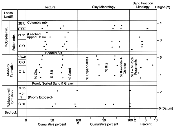
In the current exposure the Sangamon(?)-Yarmouth profile is developed mostly, if not exclusively, within the Fulton member of the McCredie Formation. The Fulton member is about 3 m thick and can be distinguished from the younger Columbia member by its lower content of igneous and metamorphic lithologies (fig. 3-12). The basal portion of the Fulton locally includes ~0.5 m of stratified sediments, mostly silts. These sediments bury the underlying Moberly Formation; hence, the weathering profile preserved atop the Moberly was not truncated by subglacial erosion.
The Moberly Formation is distinguished from the younger McCredie Formation here, as at all locations, by a lower content of expandable clay minerals (fig. 3-12). The Moberly also retains a reversed detrital remanent magnetization in contrast to the normal magnetization within the McCredie Formation. The weathering profile within the Moberly is modest here, as is true in most instances. In most cases, the upper Moberly contact is marked by a thin (<0.5 m) leached zone with or without weak soil structure. In this exposure rare clay skins coat ped surfaces, but this is the only such exposure known; generally the weak soil development is marked primarily by a concentration of redox features with very little (if any) clay enrichment and/or clay mineral alteration.
The oxidized zone within the upper Moberly Formation is generally <2 m thick in this exposure, but locally extends farther downward along polygonal joints. The lower 3 m of the Moberly generally remain unoxidized and preserve abundant wood fragments ranging in size from twigs to logs.
The oldest unlithified sediment at the Harrison Pit is buried by the Moberly Formation. This material is known informally as the "Whippoorwill formation" (see discussion by Rovey et al., this volume, p. 3-B-1). The Whippoorwill has been poorly exposed for most of the past 14 years, but it is a very fine grained diamicton with local accumulations of pebbles and cobbles. These clasts are exclusively of local bedrock lithology and include no igneous or metamorphic varieties; hence, they do not indicate glacial transport. The Whippoorwill apparently originated as some type of mass-flow into local topographic lows. This interpreted origin is consistent with a history of clay mining, because the best clay deposits in this region are often localized within paleokarst networks.
From the Harrison Pit, follow the route backwards to the I-70 and Highway 54 intersection at Kingdom City. Turn east back onto I-70 and follow it for 27 mi (43 km) to the I-70 and Highway 18 intersection at New Florence, Missouri. Exit I-70 south onto Highway 19. From the end of the exit ramp, follow Highway 19 to the south for approximately 2.7 mi (4.3 km) and turn left (east) past a gate and onto the gravel haul road leading into the Musgrove Pit.
The stratigraphy at the Musgrove Pit is summarized in fig. 3-13. This figure is based on exposures from the mid-1990's; the current highwall has a greater thickness (~12 m) of Moberly Formation. Additionally, the paleosol preserved atop the Atlanta Formation is somewhat thinner now than depicted in fig. 3-13, and the calcic horizon (the 3B2kgb horizon) is much less prominent.
The uppermost sediment exposed at the Musgrove Pit includes several meters of undifferentiated loess. As the highwall has been moved back to higher elevations, the thickness of loess has increased and multiple increments of loess are apparently preserved.
The uppermost till exposed in the Musgrove Pit is that of the Moberly Formation. In today's exposure the basal portion remains unoxidized and preserves abundant wood fragments. The Moberly till at this location contains distinct indicator clasts, including pink quartzite and most importantly Neda Formation, a distinctive oolitic iron ore. The westernmost exposure of the Neda Formation is just south of Dubuque, Iowa; hence, its presence within the Moberly indicates a regional flow direction from the northeast. The Moberly Formation here again preserves a reversed detrital remanent magnetization, indicating that it was deposited prior to the Matuyama/Brunhes reversal at 0.78 Ma.
The Moberly Formation buries a thick, wellpreserved paleosol developed atop the underlying Atlanta Formation. This unnamed paleosol locally preserves a B horizon >2 m in thickness, which indicates extreme weathering and prolonged development (see the texture and clay mineral trends in fig. 3-13). The upper portion of this paleosol preserves abundant striae and stress cutans, indicating extensive shearing and shrink-swell deformation, which are consistent with the extremely high (~80%) content of expandable clay minerals.
Figure 3-13--Lithostratigraphy of glacial and related deposits at the Musgrove Pit.
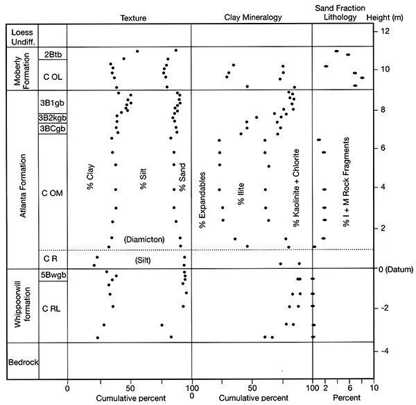
A laminated silt at the base of the Atlanta Formation preserves a reversed detrital remanent magnetization (as does the underlying Whippoorwill formation), indicating that the Atlanta Formation was also deposited during the Matuyama Reversed Chron, The extremely well developed weathering profile preserved atop the Atlanta, however, indicates that the Atlanta Formation was deposited during a much earlier portion of the Matuyama Chron than the overlying Moberly Formation (see also the discussion in Rovey et al. this volume, p. 3-B-1). If so, then the Atlanta Formation is probably Pliocene in age.
The Atlanta Formation buries ~3 m of the Whippoorwill formation, which in tum overlies Pennsylvanian-age bedrock. A weakly developed paleosol atop the Whippoorwill is preserved locally beneath a laminated silt within the base of the overlying Atlanta Formation. Thus, the Whippoorwill was apparently deposited shortly before the area was glaciated.
Five glacial tills are present in north-central Missouri along the southernmost boundary of the pre-Illinoian Laurentide ice sheet. These five tills and associated sediment are grouped into three units of formation rank, based upon clast and matrix lithology.
The oldest unit, herein named the Atlanta Formation, is preserved in stable landscape positions and is capped by an extremely well developed weathering profile. The Atlanta Formation is also distinguished by its high clast content, most of which are chert and limestone. The Atlanta preserves a reversed detrital remanent magnetization, indicating that it is older than the Matuyama/Brunhes boundary at 0.78 Ma.
The Moberly Formation locally overlies the Atlanta Formation but is generally the oldest till preserved above bedrock. The Moberly Formation is distinguished primarily by its clay-mineral content, which averages 39% expandable clay minerals. The Moberly Formation also retains a reversed detrital remanent magnetization, indicating that the Moberly was deposited during a later portion of the Matuyama Reversed Chron, before being buried by the normally magnetized McCredie Formation.
The McCredie Formation includes at least three lithologically similar tills, which are separated vertically from each other by mature weathering profiles. The McCredie Formation is distinguished primarily by its high (>50%) content of expandable clay minerals. From oldest to youngest, three informal subdivisions of the McCredie are designated as the Fulton, Columbia, and Macon members, based on stratigraphic position and differences in texture and sand-fraction lithology.
In north-central Missouri, five glacial tills are separated vertically from each other by well-preserved soil/weathering profiles, and all are present within a few kilometers of the southern glacial boundary. This boundary marks the southernmost extension of the pre-Illinoian Laurentide ice sheet (fig. 3-A-1) and is virtually coincident with the northern margin of the Ozark Dome. Apparently the largest pre-Illinoian glaciations all reached this same approximate terminus in northern Missouri where a thinning ice margin abutted the dome and was stopped by the reversal in regional topographic gradient. Therefore, presence of a till along the southern glacial boundary in north-central Missouri is a useful criterion for designating and distinguishing major pre-Illinoian continental glaciations. Accordingly, northern Missouri is a key area for understanding the pre-Illinoian glacial sequence throughout North America.
Figure 3-A-1--Map showing the present study area and its relationship to the maximum expanse of pre-Illinoian glaciation. Numerals correspond to sites listed in tables 3-A-1 and 3-A-2.
The subglacial conditions near the terminal ice margins apparently favored deposition over erosion; buried paleosol/weathering profiles are often preserved nearly intact. Thus, B horizons preserved atop each till may eventually afford the opportunity to obtain burial dates using cosmogenic-isotope techniques, and hence to determine dates of the major pre-Illinoian glaciations. Hopefully, the glacial sequence here is complete enough to establish a general stratigraphic framework for grouping and correlating pre-Illinoian deposits throughout a large portion of North America.
This paper summarizes recent work on the glacial stratigraphy of north-central Missouri, drawing heavily on Rovey and Kean (1996, 2001), Rovey (1997), Tandarich (1992, 2001), Tandarich et al. (1994), and Guccione and Tandarich (1993). We formally define three Cenozoic glacigenic formations and describe three informal members within the youngest of these formations. For continuity and to avoid confusion, we retain previously used informal names, even when recent exposures warrant a type section some distance from where a unit was first named and described.
The basic stratigraphic succession is shown in fig. 3-A-2; lithologic characteristics of each unit are summarized in table 3-A-2. In compiling table 3-A-2, we excluded samples which were either pedogenically altered or were collected from the "basal entrainment zone," an interval of ~0.5-1 m at the base of a till. Within this lower interval, a till's composition may differ significantly from the more representative overlying material due to a concentration of locally entrained substrate materials.
Table 3-A-1--Locations and names of sections shown in fig. 3-A-1 and listed in table 3-A-2.| 1. AECI Coal Pit (type area of Moberly Formation). Area around Thomas Hill Reservoir and the large AECI coal mine centered approximately 2 km northwest of Thomas Hill, Missouri. Data in this report were collected from highwalls in the NE sec. 26, T. 55 N., R. 16 W., Prairie Hill 7.5-min quadrangle. |
| 2. Blum Clay Pit. NE sec. 33, T. 52 N., R. 8 W., Mexico East 7.5-min quadrangle. |
| 3. Core SMS-92a. Intersection of Highways 63 and DD, sec. 28, T. 58 N., R. 14 W., Axtell 7.5-min quadrangle. |
| 4. Core SMS-92b (type area of McCredie Formation). Intersection of Highways 63 and M, sec. 21, T. 59 N., R. 14 W., Atlanta 7.5-min quadrangle. |
| 5. Core SMS-92c. Intersection of Highways 63 and D, NW sec. 5, T. 60 N., R. 14 W., LaPlata 7.5-min quadrangle. |
| 6. Deeker Clay Pit (type area of Atlanta Formation). NW sec. 11, T. 47 N., R. 5 W., Pinnacle Lake 7.5-min quadrangle. |
| 7. Fulton Exposure. South of Fulton, Missouri, along Highway 54, NE sec. 2, T. 46 N., R. 10 E., Guthrie 7.5-min quadrangle. |
| 8. Harrison Clay Pit. SW sec. I, T. 48 N., R. 9 W., Calwood and Kingdom City 7.5-min quadrangles. |
| 9. Highway J Intersection. Intersection of Highways 54 and J, SE sec. 31, T. 46 N., R. 10 W., New Bloomfield 7.5-min quadrangle. |
| 10. Johnson Clay Pit (type area of Atlanta Formation). NW sec. 2, T. 47 N., R. 5 W., Pinnacle Lake 7.5-min quadrangle. |
| 11. Musgrove Clay Pit (type area of Atlanta Formation). Approximately 5 km south of New Florence, Missouri, SE sec. 2 and SW sec. 1, T. 47 N., R. 5 W., Pinnacle Lake 7.5-min quadrangle. |
| 12. Reedsville Clay Pit. SW sec. 7, T. 46 N., R. 6 W., Reedsville 7.5-min quadrangle. |
| 13. Riedell Coal Pit. SE sec. 20, T. 54 N., R. 7 W., Perry 7.5-min quadrangle. |
Figure 3-A-2--Stratigraphy of pre-Illinoian glacial deposits in north-central Missouri. (A) Stratigraphic column, and (B) Summary of clay mineralogy. Each formation has a unique clay-mineral composition. Data points are the site averages listed in table 3-A-2.
Table 3-A-2--Summary of lithologic parameters. Values within each category are normalized percentages. Abbreviations: E, expandable clay minerals; I, Illite; K+C, Kaolinite + Chlorite; Sa, sand; Si, silt; Cl, clay; Q+F, quartz + feldspar; Carb, carbonates + chert; I+M, igneous + metamorphic; n, number of samples. See text and Appendix (p. 3-A-10) for additional explanations. Minor differences between percentages listed here and those in Rovey and Kean (1996) are due to analysis of additional samples at some sites and/or reanalysis of samples at the SMS laboratory.
| Location | Clay Mineralogy | Texture | Sand-Fraction Lithology |
|||||||||
|---|---|---|---|---|---|---|---|---|---|---|---|---|
| E | I | K+C | (n) | Sa | Si | Cl | (n) | Q+F | Carb | I+M | (n) | |
| Macon member, McCredie Formation | ||||||||||||
| Core SMS-92a | 47 | 25 | 28 | 3* | 36 | 34 | 30 | 5 | 58 | 28 | 9 | 3 |
| Core SMS-92b | 48 | 23 | 29 | 3* | 37 | 34 | 29 | 6 | 61 | 28 | 11 | 3 |
| Core SMS-92c | 49 | 21 | 30 | 12 | 38 | 33 | 29 | 13 | 61 | 29 | 10 | 6 |
| Avg./#Sites | 48 | 23 | 29 | 3 | 37 | 34 | 29 | 3 | 61 | 29 | 10 | 3 |
| Columbia member, McCredie Formation | ||||||||||||
| AECI Pit | 60 | 21 | 19 | 5 | 29 | 38 | 33 | 5 | 61 | 30 | 9 | 7 |
| Blum Pit | 55 | 20 | 25 | 4 | 37 | 30 | 33 | 5 | 67 | 23 | 10 | 2 |
| Core SMS-92a | 52 | 25 | 23 | 4* | 35 | 33 | 32 | 2 | 62 | 28 | 10 | 3 |
| Core SMS-92b | 52 | 25 | 23 | 3* | 36 | 30 | 34 | 5 | 55 | 34 | 11 | 5 |
| Core SMS-92c | 50 | 23 | 27 | 7* | 37 | 33 | 30 | 7 | 62 | 28 | 10 | 6 |
| Harrison Pit | 53 | 26 | 21 | 2 | 33 | 35 | 32 | 2 | 51 | 39 | 10 | 6 |
| Fulton Exposure | 51 | 27 | 22 | 5 | 29 | 40 | 31 | 8 | 49 | 42 | 9 | 6 |
| Riedell Pit | 55 | 19 | 26 | 5 | 37 | 31 | 32 | 13 | 70 | 21 | 9 | 5 |
| Avg./#Sites | 54 | 23 | 23 | 8 | 34 | 34 | 32 | 8 | 60 | 30 | 10 | 8 |
| Fulton member, McCredie Formation | ||||||||||||
| AECI Pit | 60 | 22 | 18 | 6 | 25 | 36 | 39 | 5 | 60 | 36 | 4 | 4 |
| Core SMS-92a | 56 | 23 | 21 | 5* | 28 | 37 | 35 | 8 | 63 | 31 | 6 | 7 |
| Core SMS-92b | 50 | 25 | 25 | 5* | 28 | 35 | 37 | 5 | 75 | 23 | 2 | 4 |
| Core SMS-92c | 49 | 22 | 29 | 4* | 33 | 34 | 33 | 6 | 62 | 33 | 5 | 5 |
| Harrison Pit | 56 | 27 | 17 | 4 | 23 | 38 | 39 | 6 | 58 | 38 | 4 | 4 |
| Hwy. J Intersection | 49 | 28 | 23 | 6 | 23 | 40 | 37 | 5 | 43 | 52 | 5 | 4 |
| Deeker Pit | 25 | 36 | 37 | 3 | 58 | 38 | 4 | 2 | ||||
| Avg./#Sites | 53 | 25 | 22 | 6 | 26 | 37 | 37 | 7 | 60 | 36 | 4 | 7 |
| Moberly Formation | ||||||||||||
| AECI Pit | 41 | 35 | 24 | 5 | 29 | 39 | 32 | 16 | 57 | 32 | 11 | 5 |
| Core SMS-92a | 41 | 27 | 32 | 3* | 30 | 38 | 32 | 4 | 60 | 32 | 8 | 4 |
| Core SMS-92b | 39 | 28 | 33 | 4* | 31 | 40 | 29 | 6 | 63 | 30 | 7 | 7 |
| Deeker Pit | 42 | 38 | 20 | 5 | 27 | 43 | 30 | 5 | 43 | 52 | 5 | 6 |
| Fulton Exposure | 35 | 39 | 26 | 5 | 23 | 43 | 34 | 5 | 49 | 46 | 5 | 5 |
| Harrison Pit | 39 | 36 | 25 | 3 | 30 | 43 | 27 | 4 | 57 | 38 | 5 | 4 |
| Musgrove Pit | 34 | 39 | 27 | 6 | 24 | 41 | 35 | 8 | 44 | 51 | 5 | 8 |
| Avg./#Sites | 39 | 34 | 27 | 7 | 28 | 41 | 31 | 7 | 53 | 40 | 7 | 7 |
| Atlanta Formation | ||||||||||||
| Core SMS-92b | 2 | 57 | 41 | 4 | 27 | 40 | 33 | 3 | 27 | 70 | 3 | 4 |
| Johnson Pit | 21 | 46 | 33 | 8 | 17 | 44 | 39 | 8 | 12 | 86 | 2 | 8 |
| Musgrove Pit | 26 | 36 | 38 | 5 | 13 | 50 | 37 | 6 | 7 | 91 | 2 | 6 |
| Reedsville Pit | 15 | 56 | 29 | 2 | 14 | 50 | 36 | 2 | 19 | 79 | 2 | 3 |
| Avg./#Sites | 10 | 49 | 35 | 4 | 18 | 40 | 30 | 4 | 10 | 82 | 2 | 4 |
| *Analysis by IGS | ||||||||||||
Source of Name and History: The Atlanta Formation is named for the town of Atlanta, Missouri, in Macon County, near where it was encountered by Rovey and Kean (1996) in corehole SMS-92b (fig. 3-A-1B). The Atlanta Formation was first described and named informally by Allen and Ward (1974), based on exposures within the Deeker Clay Pit. They included it within their Whippoorwill Creek formation, along with an underlying less-pebbly diamicton. Guccione (1983) later restricted the (informal) name Whippoorwill formation to the subjacent (preglacial) diamicton, without designating a name for the overlying cobbly diamicton, which is defined here as the Atlanta Formation.
Although the name "Atlanta" is associated with a major metropolitan area in another state, it is retained for conformity with historical usage--e.g., Rovey and Kean (1996, 2001), Rovey (1997), and Colgan (1999). Moreover, many other geographic names near the designated type area have already been applied formally or informally to different rock or soil stratigraphic units, and few would mistake the metropolitan area of Atlanta, Georgia, as the type area for a glacial deposit.
Type Section/Area: The type section is in the area approximately 5 km south of New Florence, Missouri, in and around the Musgrove, Johnson, and Deeker clay pits (secs. 1, 2, and 11, T. 47 N., R. 5 W, Pinnacle Lake 7.5-min quadrangle).
Description of Unit: The bulk of the Atlanta Formation is a massive, pebbly-cobbly diamicton with a very fine grained matrix (figs. 3-A-3 and 3-A-4). Most of the pebbles and cobbles are whitish chert with subordinate limestone, and these two lithologies dominate the coarse sand fraction as well. The most common type of crystalline erratics seems to be pink quartzite, but these clasts are rare. Although the diamicton is very cobbly and pebbly, its matrix generally consists of >80% fines. The clay mineral content of the <2-micron fraction is dominated by variable amounts of illite and kaolinite with only small amounts of expandable clay minerals (table 3-A-2, figs. 3-A-2B, 3-A-3). The color of this diamicton is nondiagnostic and is related in all known cases to its weathering history. Most of the clasts were apparently derived from Mississippian-age carbonates, which crop out in numerous areas north of the type area. If this is correct, the Atlanta diamicton may become less cobbly northward.
Figure 3-A-3--Stratigraphy and lithology of glacial sediments at the Musgrove Clay Pit (type area of Atlanta Formation). Weathering zone (subsolum) terminology: O, oxidized; L, leached; M, mottled; R, reduced; U, unoxidized. Datum is the base of the Atlanta Formation.
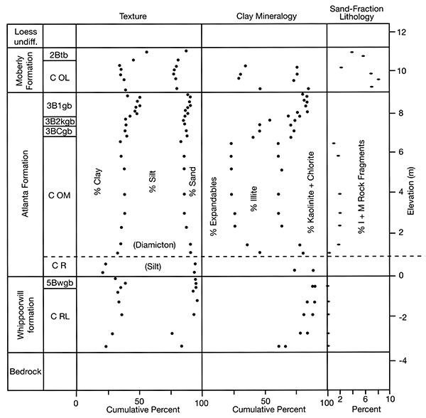
Figure 3-A-4--Atlanta Formation. Photograph shows the contact between the Atlanta Formation diamicton (above) and the Whippoorwill formation (below) at the Johnson Clay Pit.
In the type area, the diamicton described above commonly rests upon a thin <1 m), unweathered, laminated, clayey silt. This silt feathers against subjacent paleo topographic highs and locally contains scattered pebbles (dropstones) that deform subjacent laminae. The silt also contains pink quartzite in the coarse-sand fraction and is obviously genetically related to the overlying diamicton. This silt is also present in the basal meter of the overlying diamicton as discrete undeformed inclusions and more rarely along shear planes, which originate in the underlying silt and continue upward into the basal diamicton.
Contacts: The Atlanta Formation is the oldest glacigenic unit recognized in north-central Missouri. As such it overlies various Paleozoic bedrock formations throughout the region. In the type area, however, it generally overlies a preglacial diamicton known informally as the Whippoorwill formation (Guccione, 1983; Rovey et al., this volume, p. 3-B-1). In the clay-pit exposures of the type area, the upper surface is undulatory to hummocky, typically with ~3 m of local relief. The upper surface is marked by an extremely well developed paleosol and weathering profile (fig. 3-A-3). In the Musgrove and Johnson pits, this paleosol preserves a B horizon >2 m thick in the highest paleolandscape positions.
In most cases the upper surface of the Atlanta Formation is buried by the Moberly Formation. In the type area, this contact is typically marked by discontinuous, thin <0.3 m), laminated, contorted silt and poorly sorted gravelly sand, which in turn is sharply overlain by Moberly diamicton. Locally, however, the Atlanta Formation may be overlain by younger glacial diamictons or undifferentiated loess.
Differentiation: Diamicton of the Atlanta Formation is distinguished visually by its high content of chert and limestone clasts. Laboratory data also distinguish the Atlanta from all other local units (table 3-A-2). The Atlanta has a very low (average 2%) content of igneous and metamorphic rock fragments in the coarse-sand fraction and a low (average 16%) content of expandable clay minerals in the <2 micron fraction. Various mixed-layer clays are also more prominent within the Atlanta Formation, compared to the younger glacial diamictons.
There appears to have been long-standing confusion in distinguishing the present Atlanta Formation from an older subjacent diamicton now known informally as the Whippoorwill formation (Guccione, 1983). However, where both are present, the Atlanta Formation typically rests upon a discrete paleosol that caps the Whippoorwill formation. The unweathered Whippoorwill formation below this paleosol may contain scattered pebbles. Nevertheless, there is little doubt that the Whippoorwill is not a direct glacial deposit (Guccione, 1983; Rovey et al., this volume, p. 3-B-1), although its origin may be related to climate change associated with glaciation. The rare clasts and pebbles in the Whippoorwill include only local sedimentrary lithologies without crystalline erratics, and its lithology varies substantially from one exposure to the next and even from one end of an exposure to the other.
Thickness and Regional Extent: The thickness of the Atlanta Formation is quite variable, due to prolonged erosion prior to burial. In the type area it is typically ~6 m thick with a range between 4 and 7 m.
The Atlanta Formation is generally preserved only locally in very stable landscape positions; elsewhere it is completely eroded. The type area south of New Florence, Missouri, appears to be part of a paleokarst network, which explains the ubiquitous presence of paleotopographic lows ideally suited for protecting the Atlanta Formation from erosion prior to burial by younger deposits. Despite its patchy preservation, the Atlanta is easily recognized in numerous clay-pit exposures south of I-70 extending at least 40 km along a nearly east-west traverse centered around New Florence. Guccione (1973) also described an identical diamicton isolated within bedrock lows and below unweathered, reverse magnetized intertill silts (Moberly Formation) from the Columbia, Missouri, area. North of I-70 preservation of the Atlanta Formation is rare and it has been found at only one location to date (corehole SMS-92b). Nevertheless, the widespread occurrence of remnants testifies to a former continuous distribution prior to an extended period of weathering and erosion.
Interpreted Origin: The diamicton that constitutes the bulk of the Atlanta Formation is interpreted as a basal melt-out till, based on its massive unstratified nature, uniform texture, and lack of flow structure and fissility. Supraglacial till is generally quite variable in texture, reflecting partial sorting during mass flowage and resedimentation (e.g., Hallberg, 1980a; Kemmis et al., 1981), and also preserves flow structure and a quasi-stratification. The lack of fissility and "streaked" inclusions near the base of the till are evidence against a lodgment origin. The shear planes and partially deformed and remobilized substrate material in the basal meter may indicate local accumulations of deformation till, but this facies is very minor. The laminated silt, which is present beneath the till in the type area, is interpreted as a proglacial-lacustrine silt that accumulated locally in paleotopographic lows.
Age and Correlation: The laminated silt facies at the base of the formation and the underlying Whippoorwill formation both have a reversed detrital remanent magnetization (DRM) (Rovey et al., this volume, p. 3-B-1). A local accumulation of silt near the top of the diamicton at the Johnson Pit (but below the weathering profile) also preserves a reversed DRM. Considering also that the formation is capped by the reverse magnetized Moberly Formation (Rovey and Kean, 2001), the Atlanta was deposited during the Matuyama Reversed Chron (0.78-2.58 Ma). The extremely well developed weathering profile developed atop the Atlanta, along with its general absence in all but the most stable landscape positions, are evidence that it is considerably older than the overlying Moberly Formation, and therefore must date from a much earlier portion of the Matuyama Reversed Chron than the Moberly.
Rovey and Kean (1996) suggested that the Atlanta Formation is closely related to the "C-till" in eastern Nebraska and western Iowa (e.g., Easterbrook and Boellstorff, 1984). The age of the "C-till" is >2.2 Ma, based on a single fission-track data of overlying tephra (Boellstorff, 1973a, b)
Source Area: The overwhelming dominance of sedimentary lithologies within the Atlanta diamicton may be partly related to its stratigraphic position as the oldest glacial deposit; the first glacial advance would have entrained a highly weathered local regolith. Nevertheless, the very low percentage and variety of crystalline lithologies indicates a distinctly different source area than the younger glacial deposits. If the rare clasts of pink quartzite had been derived from Baraboo-type quartzite, which is exposed to the northeast, the diamicton should have additional crystalline lithologies derived from the Canadian Shield area. If, however, the quartzite is Sioux Quartzite, which is exposed to the northwest, flowlines would have followed sedimentary lithologies over a much longer distance, accounting for the overwhelming dominance of sedimentary lithologies. Therefore, the ice which deposited the Atlanta Formation probably advanced from a northwesterly direction.
Source of Name and History: The Moberly Formation is named for the town of Moberly, Missouri, in Macon County. This unit was originally included within the undifferentiated and informal "McCredie formation" of Guccione (1983). Tandarich (1992, 2001), however, recognized that the basal portion of Guccione's McCredie formation includes a (visually) subtle weathering profile above an interval with a distinct matrix lithology. Tandarich (1992, 2001) therefore proposed the name "Moberly" for this interval, as was reiterated by Rovey and Kean (1996.)
Type Section/Area: The type seetion is located in an area around Thomas Hill Reservoir and the Associated Electric Co-Op Incorporated (AECI) coal mine, centered approximately 2 km northwest of Thomas Hill, Missouri (T. 55 N., R. 15 and 16 W, Prairie Hill 7.5-min quadrangle), and approximately 20 km northeast of Moberly, Missouri.
Description of Unit: The Moberly Formation is typically a massive diamicton with a fine-grained matrix but locally includes stratified glacigenic silts and sands, particularly at the base. Moberly diamicton includes a wide variety of crystalline erratics, and at least in the exposures along I-70, it commonly contains concentrations of wood fragments near the base. Where the Moberly Formation is buried by one or more younger glacial diamictons, the lower half to two-thirds generally remains unoxidized with a nearly black color due to disseminated organic matter. The uppermost portion is generally oxidized to various brownish hues. Preliminary data obtained from boreholes taken by the Missouri Department of Natural Resources, Geological Survey and Resource Assessment Division, in St. Charles County, Missouri (east of the present study area), indicate that the Moberly may contain multiple tills with virtually identical lithology.
Contacts: Throughout most of north-central Missouri, the Moberly Formation is usually the oldest glacigenic unit preserved atop Paleozoic bedrock. In rare cases, but more commonly south of I-70, it may overlie the Atlanta Formation or deeply weathered remnants of the Whippoorwill formation. The upper formation contact is typically marked by a subtle weathering profile and soil horizon. This soil/weathering profile is generally buried by glacial diamicton and related sediment of the (informal) Fulton member of the McCredie Formation. Locally, however, the Moberly Formation may be buried by younger informal members of the McCredie Formation or by undifferentiated loess.
Differentiation: Moberly diamicton has fewer clasts than the subjacent Atlanta Formation, although the Moberly Formation contains a much higher concentration and variety of igneous lithologies. The Moberly can also be provisionally distinguished from the overlying Fulton member of the McCredie Formation by clast lithology; the Fulton diamicton also contains fewer igneous clasts than the Moberly diamicton.
Laboratory measurements are generally necessary to confirm an assignment to the Moberly Formation. The most distinct and useful parameter is the clay-mineral content (figs. 3-A-2B, 3-A-3, 3-A-5, and 3-A-6; table 3-A-2). The Moberly Formation averages 39% expandable clay minerals, whereas the McCredie Formation typically has >50%. Although some compositional parameters of the Moberly diamicton overlap with those of the overlying Fulton member of the McCredie Formation over a regional scale, the Moberly diamicton has less clay and more igneous and metamorphic rock fragments in the coarse sand fraction at any given location.
Figure 3-A-5--Stratigraphy and lithology of glacial sediments at the AECI Pit (type area of Moberly Formation). See fig. 3-A-3 for weathering-zone terminology. The base of the Moberly Formation overlies bedrock at a depth >24 m, but this contact was inaccessible at the sample location.
Thickness and Regional Extent: The Moberly Formation is nearly always present where younger glacial diamictons of the McCredie Formation are preserved. Where it is buried by the McCredie Formation, the Moberly Formation is typically 4-5 m thick; however, a much greater thickness (>18 m) is present in the type area.
Interpreted Origin: The bulk of the Moberly Formation is interpreted as basal meltout till, based on the same criteria discussed earlier for the Atlanta Formation.
Age and Correlation: Both the diamicton and unweathered subjacent silts have a reversed DRM (Rovey and Kean, 1996,2001). Therefore, the Moberly Formation is older than the Matuyama/Brunhes boundary at 0.78 Ma. The weathering profile and soil developed atop the Moberly is relatively modest in most exposures examined to date. Even where the upper paleosol surface was buried by proglacial silt and thus protected from subglacial erosion, the B horizon is relatively immature. This soil horizon is characterized by blocky structure with minor (≤4%) maximum clay enrichment, few to no clay cutans, and virtually no clay mineral alteration. Rovey and Kean (2001) therefore concluded that this paleosol developed during a relatively short interglacial period prior to being buried by the normally magnetized McCredie Formation. If this interpretation is correct, the age of the Moberly Formation would be slightly older than that of the Matuyama/Brunhes reversal at 0.78 Ma. Recent cores from St. Charles County, however, recovered a very mature B horizon approximately 2 m thick preserved atop the Moberly. Thus, the Moberly Formation may be older than previously believed.
Rovey and Kean (1996, 2001) correlated the Moberly Formation with the Alburnett Formation in eastern Iowa. The two formations are nearly identical in lithology (especially the diagnostic clay mineralogy), both occur within the same position of a nearly identical stratigraphic sequence, and both share a reversed DRM.
Source Area: The Moberly Formation contains distinct indicator clasts that isolate a source area to the northeast. Like the older Atlanta Formation, the Moberly Formation contains clasts of pink quartzite. However, clasts of oolitic iron ore (Neda Formation) recovered at the Musgrove Clay Pit are evidence that these must be Baraboo-type quartzite derived from the northeast. The Neda oolitic iron ore is a very distinct lithology that is present locally at the Ordovician-Silurian boundary throughout the upper midwestern United States. The lithology is soft enough that clasts are unlikely to survive prolonged fluvial transport or recycling through multiple glaciations, and hence they are exceptional indicators of regional provenance. The westernmost exposure of the Neda Formation is approximately 550 km northeast of the Musgrove Pit near Dubuque, Iowa, and all other known outcrops occur farther east of Dubuque. Therefore, the regional direction of ice advance must have been from the northeast.
Source of Name and History: The McCredie Formation is named after the town of McCredie, Missouri, in Callaway County. Guccione (1983) introduced "McCredie formation" as an informal name for glacigenic sediments in northern Missouri. Tandarich (1992, 2001) restricted this name to those younger deposits characterized by high contents of expandable clay minerals and that are stratigraphically above the Moberly Formation. This restriction was followed by Guccione and Tandarich (1993) and Rovey and Kean (1996, 2001).
Type Section/Area: The type section is in the area at and around the intersection of Highways 63 and M in Macon Country, Missouri (NW sec. 21, T. 59 N., R. 14 W., Atlanta 7.5-min quadrangle), where a complete sequence of McCredie Formation was obtained in a continuous core (Rovey and Kean, 1996). Tandarich (1992, 2001), followed by Rovey and Kean (1996), suggested the Harrison Clay Pit as the type section for the oldest two (informal) members within the McCredie Formation, but the youngest diamicton of the McCredie Formation is not preserved there. All of the (three) currently recognized diamictons are present in core SMS-92b (Rovey and Kean, 1996). Therefore, the location of that core is designated as the type section of the McCredie Formation.
Description of Unit: The McCredie Formation is dominated by one or more massive, fine-grained diamictons. North of I-70, related glaciofluvial sands and gravels become more common beneath individual diamictons.
The McCredie Formation includes at least three distinct diamictons (fig. 3-A-6). Where these diamictons are preserved in direct superposition, they are separated from each other by paleosol/weathering profiles and/or by bedded sands and gravels. All three diamictons within the McCredie Formation are characterized by a relatively high percentage of expandable clay minerals (figs. 3-A- 2B, 3-A-5, and 3-A-6; table 3-A-2). The color of these diamictons is nondiagnostic and is related to the local redox conditions and history.
Figure 3-A-6--Stratigraphy and lithology of glacial sediments in core SMS-92b (type area of McCredie Formation). See fig. 3-A-3 for weathering-zone terminology.
Contacts: The McCredie Formation generally overlies the Moberly Formation, although locally it may occur directly atop Paleozoic bedrock. The McCredie is generally overlain by (undifferentiated) loess resting upon a highly weathered interval associated with the Yarmouth Geosol. In some landscape positions, the upper surface is marked by a pedocomplex spanning the till-loess contact (Guccione, 1983; Rovey, 1997).
Differentiation: The McCredie Formation is distinguished from older diamictons by its higher content of expandable clay minerals (figs. 3-A-2B, 3-A-5, and 3-A-6; table 3-A-2).
Thickness and Regional Extent: The McCredie Formation is generally present within several meters of the land surface wherever younger loess deposits are preserved. The thickness of the McCredie Formation is highly variable and is related to the number of individual diamictons preserved at any given location. South of I-70 the thickness generally ranges between 0-6 m, and typically only the oldest diamicton unit (Fulton member) is preserved. Northward from I-70 the thickness ranges up to -20 m, as the younger diamictons and associated glaciofluvial sediment become thicker and better preserved.
Interpreted Origin: The bulk of the McCredie Formation diamicton is interpreted as basal meltout till, based on the same criteria as discussed previously for the Atlanta Formation. The bedded sands and gravels are interpretted as proglacial outwash.
Age and Correlation: Diamictons of the McCredie Formation have a normal DRM (Rovey and Kean, 1996, 2001). Thus the formation is apparently younger than the Matuyama/Brunhes reversal (0.78 Ma). Roveyand Kean (1996, 2001) correlated the McCredie Formation with the Wolf Creek Formation in eastern Iowa, which is also normally magnetized. The Wolf Creek Formation also includes three separate members and shares the same diagnostic clay mineralogy as the McCredie Formation.
Source Area: Diamictons of the McCredie Formation contain clasts of various crystalline lithologies, but no distinct indicator clasts have yet been recognized. The high percentage and variety of igneous clasts, however, probably preclude a far westerly source area and are more consistent with ice advance over relatively nearby outcrops of igneous terrain--i.e., the Canadian Shield area nearly directly north of Missouri.
Subdivisions: The McCredie Formation includes at least three individual diamictons. These are described below as informal members.
Fulton member: The (informal) Fulton member includes the oldest diamicton and related sediment within the McCredie Formation. The Fulton member is distinguished from younger glacial diamictons within the McCredie Formation by its stratigraphic position, a finer texture, and by its lower (~4%) content of igneous and metamorphic lithologies in the coarse-sand fraction (figs. 3-A-S and 3-A-6; table 3-A-2).
The Fulton member normally overlies the Moberly Formation, although locally it is present directly atop bedrock. Its upper surface is generally marked by a well-developed paleosol/weathering profile, including a Bt horizon of variable thickness. Generally the Fulton member is overlain by a younger diamicton (Columbia member) within the McCredie Formation, but locally may be buried by loess. Where overlain by the younger Columbia member, the Fulton member is typically ~5-6 m thick.
The name of this unit follows the designation of Tandarich (1992, 2001). If this unit is formalized, however, the prior usage of the name Fulton at the formation level in another state may necessitate a name change.
Columbia member: The (informal) Columbia member includes the second oldest diamicton and related sediment within the McCredie Formation. The Columbia member is distinguished from the older Fulton member by stratigraphic position, its coarser texture, and by a higher content of crystalline lithologies in the coarse-sand fraction (figs. 3-A-5 and 3-A-6; table 3-A-2). In many locations the Columbia is the uppermost diamicton preserved beneath undifferentiated loess. In these locations the upper surface is marked by a thick Yarmouth Geosol. Where the younger Macon member is preserved, the Columbia member is typically 5 m thick, and its upper contact is still generally marked by a Bt horizon of variable thickness. At the McCredie type section, however, this paleosol/weathering horizon is truncated to the upper C horizon.
The name of this unit follows the designation of Tandarich (1992, 2001). If this unit is formalized, however, the prior usage of the name Columbia at the formation level in another state may necessitate a name change.
Macon member: The (informal) Macon member includes the youngest glacial diamicton and associated sediment within the McCredie Formation as suggested by Rovey and Kean (1996). It is similar lithologically to the underlying Columbia member, but it can be distinguished by its stratigraphic position above a weathering profile in the underlying Columbia member. Also, at any given location, the Macon diamicton is slightly coarser in texture and contains several percent less expandable clay minerals in the <2 micron fraction (fig. 3-A-6; table 3-A-2). Where preserved, it is generally present directly below undifferentiated loess, and its upper surface is marked by a thick Yarmouth Geosol.
The Macon member is generally preserved in stable upland positions along the axis of interfluves; its preservation becomes more common northward of I-70. Its thickness is accordingly quite variable, but ranges up to 11 m in the northern part of the present study area.
All of the lithologic analyses summarized in table 3-A-2 were completed at the Southwest Missouri State University (SMS) Sediment Analysis Laboratory, except for several sets of clay-mineral analyses as noted. Those sets were completed at the Iowa Geological Survey (IGS) laboratory, and their respective values are adjusted in table 3-A-2 (see discussion below) for slight but systematic numerical differences between the two labs.
Clay mineral determinations of the <2 micron fraction were made using the technique known as the "semiquantitative" or "Glass" method (e.g., Hallberg et al., 1978; Moore and Reynolds, 1997). This technique has been widely used to characterize till lithologies throughout the midwestern U.S., and is a standard procedure at both the Illinois and Iowa Geological Surveys.
The semi-quantitative method is generally robust, but differences in preparation technique can cause slight differences in calculated percentages among different laboratories. Because the data herein are most likely to be compared to those of pre-Illinoian tills in southern Iowa (Hallberg, 1980a, 1980b), the consistency of results between the IGS and SMS laboratories was assessed using split samples of widely varying composition. To briefly summarize the clay-mineral results, the SMS laboratory consistently gives ~3% more illite and ~3% less kaolinite + chlorite than IGS analyses. There is no systematic difference between the percentages of expandable clay minerals, however. The systematic differences in the illite and the kaolinite + chlorite fractions were subsequently confirmed by resampling sections with multiple tills at two different locations: first at Conklin Quarry in Iowa (Bunker and Hallberg, 1984) and then the archived material of Core SMS-92c in Missouri (this report).
Matrix textures for the <2 mm fraction were determined following the general procedures in Walter et al. (1978). Sand percentages were determined directly by wet sieving, using 4 Φ (0.0625 mm) as the sand-silt boundary. Clay percentages were determined with the pipette method using 8 Φ (0.0039 mm) as the silt/clay boundary. For comparison, the IGS laboratory uses 0.05 mm for the sand/silt boundary and 0.002 mm for the silt/ clay boundary. Therefore, the textural percentages in table 3-A-2 are not directly comparable to textural analyses determined at the IGS laboratory. Based again on interlab comparisons of samples with a wide range in texture, the larger sand/silt boundary used at the SMS laboratory consistently gives 2% less sand compared to the IGS laboratory. The larger silt/clay boundary used at the SMS laboratory generally gives clay percentages approximately 5% higher than those determined at the IGS laboratory, but ranging from 3% to 6%.
The coarse-sand fraction (2.0-1.0 mm) was separated from the total sand fraction by wet sieving, and the composition of >1 00 grains was determined for each sample with a binocular microscope. Based on experience, the best distinction among tills in northern Missouri is achieved by normalizing the various components into three groups: Quartz + Feldspar, Carbonates + Chert, and Igneous + Metamorphic Rock Fragments. Additional lithologies, especially detrital sedimentary grains, are present but these are ignored in determining the normalized percentages in table 3-A-2.
An Igneous Rock Fragment is defined here as a compound grain containing three or more types of common igneous minerals (e.g., quartz, feldspar, micas, mafics) or a compound grain with two different types of igneous minerals and at least three individual subgrains of quartz, feldspar, or mafic minerals. Based on a comparison of SMS-laboratory analyses with published results for Conklin Quarry in Iowa by the IGS laboratory (Bunker and Hallberg, 1984), it appears that the Iowa laboratory uses different criteria to define an Igneous Rock Fragment, and sand-fraction percentages determined at the two different laboratories could not be uniquely related to each other.
Allen, W. H., Jr., and Ward, R. A., 1974, Deeker clay pit; in, Geology of East-central Missouri with Emphasis on Pennsylvanian Fire Clay and Pleistocene deposition: Guidebook Association of Missouri Geologists, 21st Annual Fieldtrip, p. 19-22.
Boellstorff, J. D., 1973a, Tephrochronology, petrology, and stratigraphy of some Pleistocene deposits in the Central Plains, USA: Unpublished Ph.D. dissertation, Louisiana State University.
Boellstorff, J., 1973b, North American Pleistocene stages reconsidered in light of probable Pliocene-Pleistocene continental glaciation: Science, v. 202, p. 305-307.
Bunker, B. J., and Hallberg, G. R., eds., 1984, Underburden-overburden--An examination of Paleozoic and Quaternary strata at the Conklin quarry near Iowa City: Geological Society of Iowa, Guidebook No. 41, Iowa Geological Survey, 81 p.
Colgan, P. M., 1999, Early middle Pleistocene glacial sediments (780 000-620 000 BP) near Kansas City, northeastern Kansas and northwestern Missouri, USA: Boreas, v. 28. p. 477-489.
Easterbrook, D. J., and Boellstorff, J., 1984, Paleomagnetism and chronology of early Pleistocene tills in the central United States; in, Correlation of Quaternary Chronologies, W. C. Mahaney, ed.: Geobooks, Norwich, England, p. 79-90.
Guccione, M. J., 1973, Bedrock geology; in, Pleistocene and Engineering Geology of North-Central Missouri:Missouri Geological Survey, Miscellaneous Publication No. 26, p. 7-40.
Guccione, M., 1983, Quaternary sediments and their weathering history in north-central Missouri: Boreas, v. 12, p. 217-226.
Guccione, M. J., and Tandarich, J. P., 1993, The Quaternary geopedology of north-central Missouri: INQUA Commission 6, Second International Paleopedology Symposium, Field Excursion August 13-20, 1993; Kansas Geological Survey, Open-file Report 93-30, p. 5-1-5-16.
Hallberg, G. R., ed., 1980a, Illinoian and pre-Illinoian stratigraphy of southeast Iowa and adjacent Illinois: Iowa Geological Survey, Technical Information Series No. 11, 206 p.
Hallberg, G. R., 1980b, Pleistocene stratigraphy in east-central Iowa: Iowa Geological Survey, Technical Information Series No. 10, 168 p.
Hallberg, G. R., Lucas, J. R., and Goodmen, C. M., 1978, Semi-quantitative analysis of clay mineralogy; in, Standard Procedures for Evaluation of Quaternary Materials in Iowa, G. R. Hallberg, ed.: Iowa Geological Survey, Technical Information Series No.8, p. 5-21.
Kemmis, T. J., Hallberg, G. R., and Lutenegger, A. J., 1981, Depositional environments of glacial sediments and landforms on the Des Moines Lobe, Iowa: Iowa Geological Survey, Guidebook Series No.6, 138 p.
Moore, D. M., and Reynolds, R. C., Jr., 1997, X-ray diffraction and the identification and analysis of clay minerals, 2nd ed.: Oxford University Press. 378 p.
Rovey, C. W., II, 1997, The nature and origin of gleyed polygenetic paleosols in the loess covered glacial drift plain of northern Missouri, USA: CATENA, v. 31, p. 153-172.
Rovey, C. W., II, and Kean, W. F., 1996, Pre-Illinoian glacial stratigraphy in north-central Missouri: Quaternary Research, v. 45, p. 17-29.
Rovey, C. W., II, and Kean, W. F., 2001, Palaeomagnetism of the Moberly formation, northern Missouri, confirms a regional magnetic datum within the pre-Illinoian glacial sequence of the midcontinental USA: Boreas, v. 30, p. 53-60.
Tandarich, J. P., 1992, A re-evaluation of profile concepts in pedology and geology: Unpublished draft of Ph.D. dissertation, University of Illinois.
Tandarich, J. P., 2001, The evolution of the profile paradigm in the history of pedology and Quaternary geology: Concepts and applications: Unpublished Ph.D. dissertation, University of Illinois.
Tandarich, J. P., Darmody, R. G., and Follmer, L. R., 1994, The pedo-weathering profile--A paradigm for whole-regolith pedology from the glaciated midcontinental United States of America; in, Whole Regolith Pedology: Soil Science Society of America, Special Publication No. 34, p. 97-117.
Walter, N. F., Hallberg, G. R., and Fenton, T. E., 1978, Particle size analysis by Iowa State University Soil Survey Laboratory; in, Standard Procedures for Evaluation of Quaternary materials in Iowa, G. R. Hallberg, ed.: Iowa Geological Survey, Technical Information Series No. 8, p. 61-74.
Age estimates of the earliest continental glaciation in North America vary by nearly half a million years and span the boundary between the Gauss (Normal) and Matuyama (Reverse) Chrons at 2.58 Ma. Part of this uncertainty is caused by a mixed magnetic polarity within the oldest glacial till throughout the midcontinental United States. Thus, previous paleomagnetic studies have been unable to resolve the till's age relative to the Gauss-Matuyama boundary.
The major pre-Illinoian glaciations all reached the same approximate southern limit in Missouri where the ice was stopped by the regional reversal in topographic gradient along the margin of the Ozark Dome. In northern Missouri the oldest glacial diamicton (Atlanta Formation) is underlain by preglacial and proglacial sediments, which accumulated within paleokarst depressions. These preglacial and proglacial sediments have a well-defined, reversed, detrital remanent magnetization. A localized silt facies within the upper Atlanta Formation also retains a reversed magnetic remanence. Thus, the initial continental glaciation to reach the maximum pre-Illinoian expanse occurred after the Gauss-Matuyama boundary at 2.58 Ma.
The timing of the Early and Middle Pleistocene (pre-Illinoian) glaciations in the midcontinental U.S. is constrained by fission-track dates of tephra interbedded between tills and by the magnetic polarity of the tills themselves (fig. 3-B-1). The Matuyama-Brunhes paleomagnetic datum separates three younger, normal-polarity tills from one or more older units with reverse polarity.
Figure 3-B-1--Pre-Illinoian glacial and magnetic sequence in the midcontinental U.S. Modified from Kemmis et al. (1992), after Easterbrook and Boellstorff (1984). Age constraints of the tills in eastern Nebraska and western Iowa are from fission-track dates of interbedded tephra (Boellstorff, 1978a, 1978b; Richmond and Fullerton, 1986a). Ages of paleomagnetic datums as discussed in the text are from Cande and Kent (1995).
One sequence of pre-Illinoian glaciation began during the late portion of the Matuyama Reversed Chron and continued through the early Brunhes Normal Chron. Deposits from the initial advance within this sequence include the reverse magnetized Alburnett and Moberly Formations in Iowa and Missouri, respectively (fig. 3-B-1). In both states the timing of this particular glaciation is estimated to be slightly older than the Matuyama-Brunhes reversal at 0.78 Ma (Richmond and Fullerton, 1986a; Rovey and Kean, 2001). Thus, these deposits would date from the early portion of enhanced glacial activity known informally as the "mid-Pleistocene climate transition" or "MPT" (Raymo et al., 1997). Later advances within this same general sequence deposited the normally magnetized Wolf Creek and McCredie Formations.
A much earlier (Pliocene) glaciation is represented by the "C till" in eastern Nebraska and western Iowa and most likely by the Atlanta Formation in Missouri (fig. 3-B-1). The timing of this older glaciation is less certain, however. A single fission-track date for tephra above the "C till" in southern Iowa (figs. 3-B-1 and 3-B-2) indicates that continental glaciation occurred prior to ~2.2 Ma (Boellstorff, 1978a, 1978b). The date implies that this early glaciation is related to the "North American glacial expansion/intensification" during the late Pliocene, ca. 2.7-2.4 Ma (e.g., Raymo, 1994; Maslin et al., 1998), and which spanned the Gauss/Matuyama boundary (2.58 Ma). Hallberg (1986) and Richmond and Fullerton (1986a) identified this tephra or ash above the "C till" as the "Pearlette B" with an accepted age of 2.01 Ma. The "Pearlette B" and the facies-equivalent Huckleberry Ridge Tuff in the Yellowstone area are associated with a transitional magnetic field (normal to reverse), presumably reflecting the upper boundary of the (upper) Reunion Normal Subchron. Recently Lanphere et al. (2002) suggested that this tuff was actually deposited during a magnetic event slightly younger than the Reunion. Nevertheless, an association with some magnetic event is supported by the fact that the underlying "C till" has mixed (samples with both reversed and normal) remanent polarity (Easterbrook and Boellstorff, 1984), in contrast with the younger pre-Illinoian tills which retain a consistent magnetic remanence of one polarity or the other. Boellstorff (1978a), however, considered this ash to be distinct from the "Pearlette B" and correlated it instead with the "Arcadia Canal" ash dated at approximately 2.3 Ma. Thus, depending on which (if either) interpretation is correct, the underlying "C till" is older than either 2.01 or 2.3 Ma.
Richmond and Fullerton (l986a), who accepted the younger ash date, assigned a tentative age of ~2.14 Ma to the "C till" and hence the earliest continental glaciation. This date would place the till deposition coincident with the transitional magnetic field of the (lower) Reunion Normal Subchron, thereby accounting for the till's mixed polarity. Boellstorff (1978a, 1978b), however, assigned a minimum age of 2.2 Ma and an actual age of ~2.4 Ma, based on paleotemperature trends inferred from oceanic sediment cores. Easterbrook and Boellstorff (1984) speculated that the "C till's" normal remanent polarity may be a primary depositional remanence acquired during the latest portion of the Gauss Normal Chron (prior to 2.58 Ma), whereas the reversed remanence would be a later overprint from the Matuyama Reversed Chron. Recently, however, Roy et al. (2004) reported a reversed magnetic remanence for the "C-till" equivalent in eastern Nebraska and western Iowa. Thus, the age estimates for the earliest North American continental glaciation span nearly half a million years and portions of two polarity chrons.
We propose that the timing of the earliest major North American continental glaciation can be constrained by examining the glacial and preglacial sediments preserved in Missouri, USA, near the southernmost advance of the pre-Illinoian ice sheet (fig. 3-B-2). Rovey and Kean (1996, 2001) presented initial interpretations of this glacial sequence, along with correlations and magnetostratigraphy, summarized here as fig. 3-B-1.
Figure 3-B-2--Location of Musgrove and Johnson clay pits. Only the Musgrove Pit is labeled, because their locations cannot be separately resolved at this scale. Shaded areas show locations from which the stratigraphic sequences depicted in fig. 3-B-1 were developed.
Rovey and Kean (1996) and Rovey and Tandarich (this volume, p. 3-A-1) documented the presence of five individual pre-Illinoian tills along the southern margin of the former Laurentide ice sheet (figs. 3-B-1 and 3-B-2). The southern margin coincides with a major regional reversal in the topographic gradient along the margin of the Ozark Dome. Hence, the largest of the pre-Illinoian glaciations all reached the same approximate southern terminus. Restated, once a critical threshold was exceeded, the southern limit of the pre-Illinoian advances was no longer constrained by the volume of ice, but by the point of reversal in topographic gradient. Therefore, we believe that presence along the margin of the Ozark Dome distinguishes "major" pre-Illinoian glaciations from less-extensive and hence minor advances.
The oldest of the five tills in Missouri is the Atlanta Formation, which occupies the same position as the "C till" within a nearly identical sequence farther north in Iowa and Nebraska. The two units also share similar lithologies and weathering histories; the most mature weathering profiles within the pre-Illinoian sequence are developed atop these two tills. Moreover, the Atlanta Formation till in Missouri also has a mixed magnetic polarity, further supporting the conclusion that these units ("C till" and Atlanta Formation) are at least broadly correlative. We recognize that deposits from still earlier glaciations may be present farther north of our study area and that conclusive evidence for correlating the Atlanta Formation and "C till" is lacking. Nevertheless, should the "C till" (or any other older till) date from an entirely different glaciation, that advance would have been considerably less extensive. Therefore, we consider the Atlanta Formation to be a deposit from the first major North American (Cenozoic) continental glaciation, regardless of its exact correlation to other units.
Recent activity in Missouri's clay mining district has exposed preglacial and proglacial sediments beneath Atlanta Formation till. Therefore, the primary objective of this project was to measure the magnetic polarity of these subjacent sediments to determine whether the first glaciation known to have reached Missouri occurred before or after the Gauss-Matuyama boundary at 2.58 Ma.
The new data presented here were obtained by analyzing samples collected from high walls of the Musgrove and Johnson clay pits, located in Missouri's Fire Clay District. These pits are approximately 8 km north of the pre-Illinoian glacial boundary (fig. 3-B-2) and are within the type area of the Atlanta Formation (Rovey and Tandarich, this volume, p. 3-A-2). Previous samples of the Atlanta Formation's till facies gave mixed results (Rovey and Kean, 1996, unpublished data this study). Most samples had a reversed magnetic remanence, but some samples were normally magnetized, while others had multiple components of both normal and reverse polarity. Thus, the original detrital remanent magnetization was unclear, based upon analysis of the till facies. Recently, mining in these pits exposed more-localized silty facies within or subjacent to the Atlanta Formation that are more likely to faithfully record the earth's magnetic polarity during deposition.
At the Musgrove Pit, paleomagnetic samples were taken along vertical transects at three different locations. In the following tables and text, we refer to Transect 1 (mid-location of 1996 northern highwall), Transect 2 (west end of the 1999-2000 northern highwall), and Transect 3 (east end of the 1999-2000 high wall). In 2002 a suite of samples was also collected from new exposures in the Johnson Pit.
Samples were taken by pressing a small, oriented plastic box into a leveled surface. Each sample was subjected to stepwise a.f. demagnetization. Demagnetization was generally halted after reaching 100 mT, or after the sample's natural remanent magnetization (NRM) intensity declined to <10% of its original value or to random noise level.
After each demagnetization step, the magnetic remanence was measured in multiple orientations using a Molspin GS-1 magnetometer. The replicate vector components at each step were used to calculate a reproducibility factor, which is a guide to both the stability of remanence and the optimal demagnetization level. After demagnetization, the low-field magnetic susceptibility was measured for each sample. For selected samples the remanence intensity was measured under a series of applied D.C. fields to construct isothermal remanent magnetization (IRM) curves to help assess the mineral carrier of the magnetic remanence.
The sedimentary sequence preserved and exposed within the Musgrove and Johnson pits is related to the local bedrock topography. In this district, kaolinitic clay is mined from the Pennsylvanian-age Cheltenham Formation, and the purest facies is restricted to paleokarst features developed in the underlying Mississippian-age limestones. Hence, the mining activity is often localized within a paleokarst network. These paleokarst features remained as isolated bedrock lows prior to glaciation and thus functioned as small, localized depositional basins in which preglacial and proglacial sediments accumulated.
The oldest diamicton within the Musgrove and Johnson pits is known informally as the Whippoorwill formation (Guccione, 1983). This deposit is present within the preglacial paleotopographic lows but is absent from higher landscape positions. The Whippoorwill is a leached, mildly gleyed, massive diamicton with rare oxidized mottles and scattered pebbles. In places it resembles a till, but only local, and no erratic, lithologies are present. The matrix lithology varies substantially from one pit to another, suggesting that these sediments were derived from local source areas immediately surrounding each depocenter.
The Whippoorwill formation's geometry is consistent with a mass-flow or sheet-flow origin. Its presence is limited to bedrock depressions, and its thickness is greatest around the perimeter of paleosinks. This ramplike geometry suggests gravitational transport of saturated soil/residuum from surrounding upland areas into the paleosinks. Thus, the leached condition reflects its depositional state, not subsequent weathering. Likewise, the mildly reduced condition is syndepositional; gleying does not extend below the lower Whippoorwill boundary, nor upward into the overlying till (fig. 3-B-4a). The deposit lacks flow structure, discrete internal weathering surfaces, and stratified interbeds, indicating that the unit may have originated as a solifluction/gelifluction deposit. If this interpreted origin is correct, deposition may be related to climatic cooling associated with the onset of glaciation.
Guccione (1983) described a mature paleosol developed within the upper Whippoorwill formation, but only from locations where it is overlain by much younger materials. In contrast, the Whippoorwill at the Musgrove Pit is capped by a subtle weakly developed paleosol marked only by a blocky structure, slightly more intense gleying, and by carbonized root traces. This horizon has very little clay accumulation or alteration, despite developing under gleying conditions, which are conducive to the formation of expandable clay minerals. In the Johnson Pit, no weathering profile is present atop the Whippoorwill, and its upper contact is gradational to a laminated silt facies with scattered dropstones, the basal part of the overlying Atlanta Formation. Thus, at the Johnson Pit, deposition of the Whippoorwill formation apparently ceased immediately prior to burial by the earliest glacial sediments.
An upward increase in the expandable clay mineral content over the basal meter of the Whippoorwill formation at the Musgrove Pit (fig. 3-B-3) might be taken as evidence for minor clay neoformation, qualifying most of this unit as a BC horizon and indicating a longer duration of weathering. However, a pedogenic increase in expandables would be accompanied by a decrease in illite, which is easily degraded (see for example the clay-mineral trends in the overlying 3B horizon). The nearly constant illite percentage throughout most of this unit indicates a lack of pedogenic alteration except within and just below the 5Bwg horizon (fig. 3-B-3). Therefore, at the Musgrove Pit, a break occurred between deposition of the Whippoorwill formation and burial by the Atlanta Formation, but this time interval was only sufficient for a weak soil profile to form.
Figure 3-B-3--Matrix properties of Quaternary sediments at Musgrove Clay Pit. Results shown are a composite of several individual sampling transects. Subscripts denote the following: O, oxidized; M, mottled; U, unleached; R, reduced; L, leached.
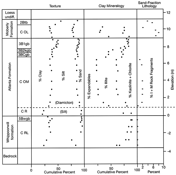
The Atlanta Formation is the oldest unquestioned glacigenic deposit recognized in northern Missouri (Rovey and Kean, 1996; Rovey and Tandarich, this volume, p. 3-A-2). The Atlanta is completely eroded at most locations; its preservation is rare and limited to stable landscape positions such as the paleosinkholes within the present study area. Where locally preserved beneath younger deposits, a very thick (>2 m) B-horizon paleosol is developed atop the Atlanta Formation till (see the discussion and figures that follow). This soil horizon, along with the Atlanta Formation's general absence, attest to a long duration of weathering and erosion between its deposition and that of the younger tills, which date from the MPT, ca. 0.8-0.5 Ma (fig. 3-B-1).
Figure 3-B-4--Basal contact of Atlanta Formation till. (A) Contact between Atlanta Formation till and underlying Whippoorwill formation, Johnson Pit. (B) Contact (at box) between Atlanta Formation till and underlying proglacial silt, Musgrove Pit. The silt is present locally within swales on the surface of the underlying Whippoorwill formation. Contact between the silt and underlying Whippoorwill formation is at shovel. The upper Atlanta contact with the overlying Moberly Formation is at the abrupt transition to an unoxidized diamicton with fewer clasts.
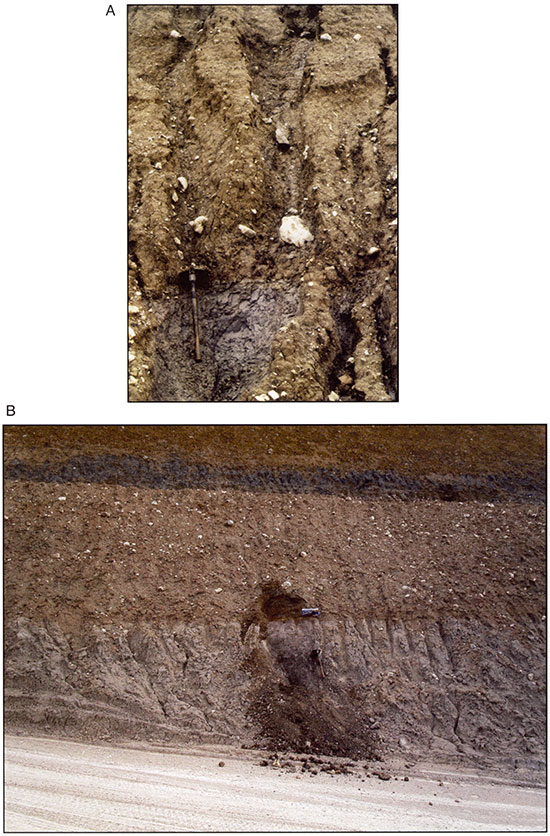
The lowest increment of the Atlanta Formation at the Musgrove and Johnson pits is proglacial silt (fig. 3-B-4b). This silt superficially resembles the subjacent Whippoorwill formation, but is slightly calcareous, less intensely gleyed, and locally rests upon a discrete paleosol. Moreover, the silt is faintly laminated, implying a stratified aqueous origin. The reduced condition does not extend upward into the overlying till, and hence, the gleyed coloration again appears to be syndepositional, possibly caused or enhanced by incorporation of reworked sediment from the underlying Whippoorwill formation.
The silt's composition indicates an approaching glacial source. At the Musgrove Pit, the illite percentage, which is quite low in the underlying bedrock and residuum, increases sharply within the silt. Moreover, the sand fraction includes rare, crystalline rock fragments which are absent from the subjacent materials, and the same facies at the Johnson Pit contains scattered pebbles (dropstones) that deform subjacent laminae.
The silt's upper contact with the overlying till is sharp and erosional. Most of the erosion was apparently subglacial; discrete blocks of the silt are commonly incorporated into the basal few centimeters of the overlying till.
The bulk of the overlying Atlanta Formation is a cobbly diamicton (fig. 3-B-4). Most of this diamicton is interpreted as basal meltout till, based on its uniform matrix composition (fig. 3-B-3), a lack of fissility, and the absence of flow structures. Shear structures are also generally lacking, except locally near the base, and extending downward into the upper few centimeters of the subjacent silts.
Several meters of erosional relief are present along the Atlanta Formation's upper contact. This upper surface preserves a paleosol developed during an exceptionally long period of weathering, relative to other paleosols within the pre-Illinoian sequence. Although clay enrichment within this solum appears modest based on fig. 3-B-3, that appearance is deceptive, because the clay enrichment (approximately 12%) is uniform throughout the entire upper meter. Extreme weathering can also be adduced from trends in clay mineralogy. The expandable clay minerals increase upward from approximately 25% of the clay fraction below the solum to 80% within the 3B1 horizon. Concomitantly, illite decreases upward from approximately 40% to zero and is completely degraded within the upper meter. Also, the solum grades upward from moderately stony (16-35%) at the base to very slightly stony 0-5%) at the top. This gradation must be due to weathering and not an accretionary accumulation of fine-grained material, because it is best expressed in the topographically highest portions of the solum and not within lower swales.
This paleosol retains abundant stress cutans and striated slickensides in the upper 3B1 horizon, which underwent extensive shearing and homogenization (note the uniform texture within the 3B1, fig. 3-B-3). Considering also that the upper portion is approximately 50% clay, of which 80% is expandable, this soil must have been a Vertisol or vertic intergrade. Therefore, the soil's maturity cannot be assessed using standard weathering indices (e.g., Harden, 1982; Harden and Taylor, 1983). Nevertheless, the pedogenic changes within this solum are more extreme than any we have yet encountered within a Quaternary-age paleosol and exceed those of the composite Yarmouth-Sangamon Geosol, even where the latter developed under similar reducing conditions (e.g., Rovey, 1997).
The composite Yarmouth-Sangamon Geosol formed over an approximate 0.5 Ma duration (Richmond and Fullerton, 1986b). Therefore, by comparison, we estimate that the Atlanta Formation till weathered for at least 0.5 Ma prior to burial by the overlying Moberly Formation. Given that the Moberly Formation was deposited during the latest portion of the Matuyama Chron (Rovey and Kean, 2001), the minimum age of the Atlanta Formation would be about 1.3 Ma. The actual age, however, is probably much greater.
To date we have been unable to isolate a consistent magnetic remanence of just a single polarity within the Atlanta Formation till. Therefore, we focus primarily on results from subjacent materials to determine the state of the magnetic field shortly before glaciation.
Table 3-B-1--Summary of measurements, Whippoorwill formation. Grouped samples were taken at the same stratigraphic level; numerals in sample labels refer to elevation (m) relative to the Whippoorwill formation's upper contact. "Single point" values are those at the optimum a.f. demagnetization level, based on the reproducibility of measurements in multiple orientations. Demagnetization levels refer to peak a.f. fields in mT. PCA values are principal components isolated from the demagnetization sequence (maximum angular deviation < 10°). κ is the Fisher precision parameter, alpha 95 is the 95% confidence limit (degrees) about the mean direction.
| Sample | Single Point | Demag. Level |
PCA | |||
|---|---|---|---|---|---|---|
| Inc. | Dec. | Inc. | Dec. | Range | ||
| ML-.30a | -41 | 152 | 30 | -39 | 153 | 20-origin |
| ML-.30b | -52 | 176 | 30 | -44 | 178 | 40-origin |
| ML-.46a | -42 | 175 | 40 | -41 | 180 | 30-origin |
| ML-.46b | -53 | 176 | 40 | -50 | 171 | 40-origin |
| ML-.61a | -37 | 194 | 40 | -38 | 193 | 30-origin |
| ML-.61b | -48 | 201 | 30 | -48 | 201 | 30-origin |
| Vector Mean: | -47 | 179 | -44 | 179 | ||
| κ: | 35. | 38. | ||||
| Alpha 95: | 9.7 | 9.3 | ||||
Samples from the upper Whippoorwill formation were taken along Transect 3 and span the interval below and within the upper paleosol. Each sample had a stable and highly significant reversed characteristic remanence (ChRM) carried by magnetite. These samples lacked normal components of magnetization, except those obviously acquired within the current field and expressed as a weak, viscous remanent magnetization (VRM). The grouped samples have a high Fisher Precision Parameter (κ) up to 38, and a 95% confidence limit (α95) of <10° about the mean orientation (table 3-B-1).
These samples had a consistent reversed declination through the entire demagnetization sequence. Inclinations flipped from shallow normal to reverse by 5 mT demagnetization, as the VRM from the current magnetic field was removed (fig. 3-B-5). Most of the VRM was removed by 5 mT, although slight viscous effects persisted in some samples up to 20-30 mT demagnetization, as indicated by the removal of shallow difference vectors. Above this range, difference vectors stabilized and coincided with the measured remanence directions, implying that demagnetization had isolated the ChRM. Principal Components Analysis (PCA) also isolates a highly significant reversed remanence beginning at around 30 mT, consistent in each case with the optimum demagnetization level inferred from the reproducibility factor (table 3-B-1).
This reversed ChRM is carried by magnetite. Sample coercivities (median destructive a.f. fields) range from approximately 20 to 50 mT, consistent with single-domain magnetite (Lowrie and Fuller, 1971; Heider et al., 1987). Very little remanence remains after 60 mT demagnetization (fig. 3-B-5). Therefore, despite the oxidized mottles, there is no significant amount of hematite or iron hydroxides, which may form authigenically with a harder secondary chemical remanent magnetization (CRM). Thus, the reversed polarity must be a primary detrital remanent magnetization (DRM).
Figure 3-B-5--Vector intensity diagrams, Whippoorwill formation. Units are those of intensity (A/m x 10-3).
Figure 3-B-6--Vector intensity diagrams, proglacial silt, Atlanta Formation. Sample Mg+.30c is unusual in that a.f. demagnetization continues above 60 mT.
The Atlanta Formation silt, which is subjacent to the till facies, was sampled along all three transects. Three samples from Transect 1, however, were collected at a location where the silt was sheared. These three samples apparently had a reversed remanence, but the results are equivocal.
Table 3-B-2--Summary of measurements, proglacial silt of Atlanta Formation, Musgrove Pit. Grouped samples were taken at the same stratigraphic level; numerals in sample labels refer to elevation (m) relative to the silt's lower contact. See table 3-B-1 for further explanations. Demagnetization of the "ML" series was stopped at 60 mT. The lack of a highly significant vector component (PCA analysis) in some samples is related to the presence of a "hard" remanence above 60 mT. Therefore, some samples stopped demagnetizing and lack a well-defined vector trend toward the origin.
| Sample | Single Point | Demag. Level |
PCA | Range | ||
|---|---|---|---|---|---|---|
| Inc. | Dec. | Inc. | Dec. | |||
| ML+.86a | -40 | 138 | 30 | -21 | 182 | 30-60 |
| ML+.86b | -36 | 146 | 20 | -48 | 101 | 30-60 |
| MG+.61a | -70 | 99 | 20 | -82 | 58 | 6O-origin |
| MG+.61b | -61 | 130 | 20 | -74 | 95 | 40-60 |
| MG+.6ac | -55 | 126 | 20 | -52 | 126 | 20-50 |
| MG+.61d | -61 | 164 | 40 | None | ||
| MG+.61e | -68 | 161 | 40 | None | ||
| Group Mean: | -65 | 137 | -71 | 109 | ||
| κ: | 41. | 20. | ||||
| alpha 95: | 9.8 | 18. | ||||
| MG+.30a | -61 | 149 | 20 | None | ||
| MG+.30b | -72 | 272 | 40 | None | ||
| MG+.30c | -47 | 148 | 20 | -53 | 200 | 25-60 |
| MG+.30d | -70 | 162 | 40 | -76 | 194 | 15-30 |
| MG+.30e | -50 | 188 | 20 | -58 | 197 | 30-50 |
| Group Mean: | -65 | 171 | -63 | 187 | ||
| κ: | 13. | 28. | ||||
| alpha 95: | 17. | 15. | ||||
| ML+.06a | -67 | 212 | 60 | None | ||
| ML+.06b | -43 | 208 | 60 | None | ||
| ML+.06c | -42 | 181 | 60 | None | ||
| Group Mean: | -51 | 198 | ||||
| κ: | 21. | |||||
| alpha 95: | 18. | |||||
| Totals: | -61 | 162 | -66 | 158 | ||
| κ: | 13. | 7.6 | ||||
| alpha 95: | 9.9 | 18. | ||||
The remaining 15 samples from Transects 2 and 3 span the silt's maximum preserved thickness and have magnetic characteristics very similar to the subjacent Whippoorwill formation. Most importantly, the silt shares a reversed DRM (fig. 3-B-6, table 3-B-2). The silt, however, retains a slightly harder magnetic remanence, implying that minor amounts of hematite are present.
Most of the VRM affecting the silt was removed by 5-10 mT of a.f. demagnetization, although slight effects again persisted to 20-30 mT. In eight samples, PCA isolated a highly significant reversed ChRM between approximately 20 and 60 mT (fig. 3-B-6). Above 60-70 mT of a.f. demagnetization, these samples ceased to demagnetize and the remanence directions stabilized at intensities ranging from 5 to 30% of the peak NRM value. A single thermally demagnitized sample (Transect 1) and IRM curves confirm that this hard remanence is due to small quantities of hematite.
Despite the presence of hematite within the silt, there is no indication that this mineral is authigenic. The hard magnetization isolated above 60 mT is also reversed with nearly identical remanence directions as the softer remanence carried by magnetite and isolated at lower demagnetization levels. Therefore, although the silt has two mineral carriers of magnetization, it has a single reversed DRM. Samples from the same relative elevations have good group statistics (table 3-B-2) with Fisher κ values ranging up to 41.
A very localized silt facies was exposed within the upper Atlanta Formation at the Johnson Pit during the summer of 2002. This silt was intercalated laterally with the diamicton/till facies and in turn was overlain by a separate diamicton with possible flow structure. The geometry and contacts of these different facies closely resembled supraglacial flow deposits that have been extensively documented from the Des Moines Lobe (e.g., Kemmis et al., 1981) and many other modern settings. The paleosol capping the upper till surface continued without diminution above the silt within the upper part of the overlying diamicton. Therefore, the age of the silt is very close to that of the till facies, even if it was not strictly syndepositional. Like the subjacent silts, this upper silt facies retains a highly significant reversed DRM (table 3-B-3).
Table 3-B-3--Summary of measurements, upper silt facies in Atlanta Formation, Johnson Pit. Grouped samples were taken at the same stratigraphic level; numerals in sample labels refer to elevation (m) above the formation's lower contact. See table 3-B-1 for further explanations. The two samples labeled as "unstable" had reversed polarity, but had a low magnetic intensity, which decreased to "noise level" before the overprint from the viscous remanent magnetization (VRM) was completely removed.
| Sample | Single Point | Demag. Level |
PCA | Range | ||
|---|---|---|---|---|---|---|
| Inc. | Dec. | Inc. | Dec. | |||
| Js2.3a | -53 | 201 | 30 | None | ||
| Js2.3b | Unstable | None | ||||
| Js2.2a | -27 | 202 | 30 | -27 | 177 | 10-origin |
| Js2.2b | -27 | 182 | 30 | -27 | 158 | 10-origin |
| Js1.9a | -50 | 201 | 30 | -31 | 212 | 20-origin |
| Js1.9b | -34 | 228 | 30 | -35 | 223 | 10-origin |
| Js1.8a | -25 | 188 | 20 | -23 | 188 | 20-origin |
| Js1.8b | -84 | 127 | 30 | None | ||
| Js1.7a | Unstable | None | ||||
| Js1.7b | -44 | 125 | 30 | -44 | 115 | 20-origin |
| Vector Mean: | -46 | 170 | -36 | 179 | ||
| κ: | 7.7 | 3.4 | ||||
| Alpha 95: | 18. | 31. | ||||
The magnetic sequence within the Whippoorwill formation and basal Atlanta Formation silts (fig. 3-B-7) supports the observational conclusion that these units were deposited with just minor interruption. A prominent easterly shift in declination continues across the contact of these two units. These units are not oxidized, and accordingly the reversed magnetic remanence lacks any evidence of a secondary CRM overprint, as might be associated with secondary iron oxides/hydroxides formed during oxidation. Therefore, this remanence is a primary DRM. The upper silt facies locally present at the Johnson Pit also retains a reversed DRM. Moreover, the Atlanta Formation is overlain by the reverse magnetized Moberly Formation. Although the upper Moberly Formation is locally overprinted with a secondary (normal) CRM, this later magnetization is easily distinguished from a DRM by its magnetic mineralogy, harder remanence, and erratic demagnetization (Rovey and Kean, 2001).
Figure 3-B-7--Summary of magnetic remanence directions, Musgrove Pit. Plotted values are the "single point" values from tables 3-B-1 and 3-B-2. Intensities (A/m x 10-3) are measured after 20 mT of peak a.f. demagnetization and normalized by bulk susceptibility (10-5 SI).
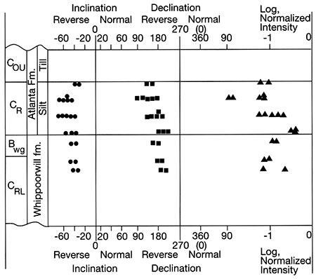
In summary, sediments below, within, and above the Atlanta Formation consistently have a reversed DRM. Therefore, the Atlanta Formation was deposited during the Matuyama Reversed Chron (2.58-0.78 Ma).
Based on the previous evidence and discussion, we can make several conclusions, albeit with varying degrees of confidence.
Beard, J. H., 1969, Pleistocene paleotemperature record based on planktonic foraminifers, Gulf of Mexico: Transactions, Gulf Coast Association of Geological Societies, v. 19, p. 535-543.
Boellstorff, J. D., 1978a, Chronology of some Late Cenozoic deposits from the central United States and the ice ages: Transactions of the Nebraska Academy of Sciences, v. 6, p. 35-48.
Boellstorff, J., 1978b, North American Pleistocene stages reconsidered in light of probable Pliocene-Pleistocene continental glaciation: Science, v. 202, p. 305-307.
Cande, S. C., and Kent, D. Y., 1995, Revised calibration of the geomagnetic polarity timescale for the Late Cretaceous and Cenozoic: Journal of Geophysical Research, v. 100, no. B4, p. 6,093-6,095.
Easterbrook, D. J., and Boellstorff, J., 1984, Paleomagnetism and chronology of early Pleistocene tills in the central United States; in, Correlation of Quaternary Chronologies, W. C. Mahaney, ed.: Geobooks, Norwich, p. 79-90.
Guccione, M. J., 1983, Quaternary sediments and their weathering history in north-central Missouri: Boreas, v. 12, p.217-226.
Hallberg, G. R., 1986, Pre-Wisconsin glacial stratigraphy of the central plains region in Iowa, Nebraska, Kansas, and Missouri; in, Quaternary Glaciations in the United States of America, G. M. Richmond and D. S. Fullerton, eds.: Quaternary Sciences Reviews, v. 5, p. 11-15.
Harden, J. W., 1982, A quantitative index of soil development from field descriptions: Examples from a chronosequence in central California: Geoderma, v. 28, p. 1-28.
Harden, J. W., and Taylor, E. M., 1983, A quantitative comparison of soil development in four climatic regimes: Quaternary Research, v. 20, p. 342-359.
Heider, F., Dunlop, D. J., and Sugiura, N., 1987, Magnetic properties of hydrothermally recrystallized magnetite crystals: Science, v. 236, p. 1,287-1,290.
Joyce, J. E., Tjalsma, L. R. c., and Prutzman, J. M., 1993, North American glacial meltwater history for the past 2.3 m.y.--Oxygen isotope evidence from the Gulf of Mexico: Geology, v. 21, p. 483-486.
Kemmis, T. J., Bettis, E. A., III, and Hallberg, G. R., 1992, Quaternary geology of Conklin quarry: Iowa State Geological Survey, Guidebook Series 13, 41 p.
Kemmis, T. J., Hallberg, G. R., and Lutenegger, A. J., 1981, Depositional environments of glacial sediments and landforms on the Des Moines Lobe, Iowa: Iowa Geological Survey, Guidebook Series Number 6, 138 p.
Knies, J., Mattheissen, J., Yogt, c., and Stein R., 2002, Evidence of Mid-Pliocene (~3 Ma) global warmth in the eastern Arctic Ocean and implications for the Svalbard/Barents Sea ice sheet during the late Pliocene and early Pleistocene (~3-1.7 Ma): Boreas, v. 31, p. 82-93.
Lanphere, M. A., Champion, D. E., Christiansen, R. L., Izett, G. A., and Obradovich, J. O., 2002, Revised ages for tuffs of the Yellowstone Plateau volcanic field-Assignment of the Huckleberry Ridge Tuff to a new geomagnetic polarity event: Geological Society of America, Bulletin, v. 114, no. 5, p. 559-568.
Lowrie, W., and Fuller, M., 1971, On the alternating field demagnetization characteristics of multidomain thermo remanent magnetization in magnetite: Journal of Geophysical Research, v. 76, p. 6,339-6,349.
Maslin, M. A., Li, X. S., Loutre, M. F., and Berger, A., 1998, The contribution of orbital forcing to the progressive intensification of Northern Hemisphere glaciation: Quaternary Science Reviews, v. 17, p. 411-426.
Prueher, L. M., and Rea, D. K., 1998, Rapid onset of glacial conditions in the subarctic North Pacific region at 2.67 Ma-Clues to causality: Geology, v. 26, p. 1,027-1,030.
Raymo, M. E., 1994, The initiation of Northern Hemisphere glaciation: Annual Reviews of Earth and Planetary Science, v. 22, p. 353-383.
Raymo, M. E., Oppo, D. W., and Curry, W., 1997, The mid-Pleistocene climate transition--A deep sea carbon isotopic perspective: Paleoceanography, v. 12, no. 4, p. 546-559.
Richmond, G. M., and Fullerton, D. S., 1986a, Summation of Quaternary glaciations in the United States of America; in, Quaternary Glaciations in the United States of America, G. M. Richmond and D. S. Fullerton, eds.: Quaternary Sciences Reviews, v. 5, p. 183-196.
Richmond, G. M., and Fullerton, D. S., 1986b, Introduction to Quaternary glaciations in the United States of America; in, Quaternary Glaciations in the United States of America, G. M. Richmond and D. S. Fullerton, eds.: Quaternary Sciences Reviews, v. 5, p. 3-10.
Rovey, C. W., II, 1997, The nature and origin of gleyed polygenetic paleosols in the loess covered glacial drift plain of northern Missouri, USA: Catena, v. 31, p. 153-172.
Rovey, C. W., II, and Kean, W. F., 1996, Pre-Illinoian glacial stratigraphy in north-central Missouri: Quaternary Research, v. 45, p. 17-29.
Rovey, C. W., II, and Kean, W. F., 2001, Palaeomagnetism of the Moberly formation, northern Missouri, confirms a regional magnetic datum within the pre-Illinoian glacial sequence of the midcontinental USA: Boreas, v. 30, p. 53-60.
Roy, M., Clark, P. U., Barendregt, R. W., Glasmann, J. R., and Enkin, R. J., 2004, Glacial stratigraphy and paleomagnetism of late Cenozoic deposits of the north-central United States: Geological Society of America, Bulletin, v. 116, no. 1/2, p. 30-41.
Shackleton, N. J., Backman, J., Zimmerman, H., Kent, D. V., Hall, M. A., Roberts, D. G., Schnitker, D., Baldauf, J. G., Desprairies, A., Homrighausen, R., Huddlestun, P., Keene, J. B., Kaltenback, A. J., Krumsiek, K. A. O., Morton, A. c., Murray, J. W., and Westberg-Smith, J., 1984, Oxygen isotope calibration of the onset of ice-rafting and history of glaciation in the North Atlantic region: Nature, v, 307, p. 620-623.
St. John, K. E. K., and Krissek, L., 2002, The late Miocene to Pleistocene ice-rafting history of southeast Greenland: Boreas, v. 31, p. 28-35.
van Donk, J., 1976, O18 record of the Atlantic Ocean for the entire Pleistocene Epoch; in, Investigation of Late Quaternary Paleoceanography and Paleoclimatology, R. M. Cline and J. D. Hays, eds.: Geological Society of America, Memoir 145, p. 147-163.
Prev--Pre-Meeting Field Trip 2 || Next--Post-meeting Field Trip 4
Kansas Geological Survey
Comments to webadmin@kgs.ku.edu
Web version July 7, 2014. Original publication date 2006.
URL=http://www.kgs.ku.edu/Publications/Bulletins/TS21/field_trip3.html