Kansas Geological Survey, Technical Series 10
The University of Kansas, Department of Geography
Originally published in 1997 as Kansas Geological Survey Technical Series 10. This is, in general, the original text as published. The information has not been updated. An Acrobat PDF version (6 MB) is also available.
Cover photographs: Two sodic soils of the tentative Punkin series in Reno County, Kansas. Courtesy of Gary Parker, National Resource Conservation Service.
Soil surveys published by the U.S. Department of Agriculture Natural Resources Conservation Service (NRCS; formerly Soil Conservation Service [SCS]) for each of the 105 counties in Kansas were reviewed to assess the extent and distribution of soils affected by sodium or salinity throughout the entire state. Salt-affected soils have important implications for soil-management practices. A list of affected soil series was compiled along with maps to illustrate the distribution. The list and maps were subsequently refined using information obtained from the State Soil Survey Data Base maintained by the NRCS. A liberal interpretation of what constitutes an affected soil was employed in order to include all soils that might be only slightly affected by either sodium or salinity. However, discounting all such slightly affected soils still leaves more than one million acres of soils in Kansas (less than 2% of the total area of the state) that are affected by sodium or salinity to a degree great enough to be classified as saline, sodic, or saline-sodic, based on the accepted definition of these terms. A total of 84 counties identified as containing at least one soil series that may be slightly affected by sodium or salinity illustrates a distribution more widespread than one might expect for the state of Kansas. Given the variations in climate, landscape position, and parent materials of the soils identified, it suggests that occurrences of affected soils are a function of a combination of factors upon a generally widespread presence of at least slight levels of salinity throughout the Kansas environment. It suggests, also, a need for greater sensitivity to the possibility of both existing and potential occurrences of affected soils in the development and use of Kansas landscapes.
The soil surveys published by the U.S.Department of Agriculture Soil Conservation Service (SCS), now called the Natural Resources Conservation Service (NRCS), for each of the 105 counties in Kansas were reviewed to determine the full extent of salt- and sodium-affected soils in the state (as mapped by these soil surveys). This review was prompted by the authors' desire to assess the uniqueness of one particular occurrence of sodium-affected soil (the Bavaria series in Saline County), and their interest in evaluating the relationship of this and other sodium-affected soils in Kansas to the surrounding landscapes. The review identified specific soil series, together with their general distribution, which are classified as natric, sodic, or saline, or are typically affected by sodium or salinity to some degree throughout their range. In general, the soils identified are naturally affected by sodium and/or salinity rather than a result of irrigation practices, oil-field-brine overflow, or some other human-caused contamination. The soils identified through this statewide review have important implications for soil-management practices, and knowing their distribution serves as a caution for anyone reading this report.
Several tables of information within each published soil survey can provide some indication of the salinity or sodicity of a particular soil. These indicators include: the classification of a soil; salinity measurements, when provided, in the table of physical and chemical properties; assignment of saline-range sites; use of the term slickspot in the name of a soil-map unit; and to some extent, references to excess salt or excess sodium in one or more columns of the interpretations tables. Using information collected from these sources, a list of the specific soil series was compiled along with several maps which generally illustrate the distribution and extent of these soils. Additional information obtained from the State Soil Survey Data Base maintained by the NRCS, as well as personal communication with NRCS soil scientists, allowed further refinement of this list and of the related maps. This information included access to a complete set of the most recent Soil Interpretations Records (SIRs, aka SOILS-5s) for all the soil series mapped in the state of Kansas.
Finally, some effort was made to document relevant recorrelations. Certain individual map units, especially in the older soil surveys, have been recorrelated by the NRCS to soil series other than as originally mapped. For example, a map unit that was originally mapped as an affected exception to a normally unaffected soil series may have been recorrelated to a series that is considered to be affected wherever it is mapped; or a map unit that was originally unclassified (e.g., a map unit named "Saline Alluvial Land") will have been subsequently correlated to the soil series which best represents what is actually found in that map unit. These recorrelations have been necessary to integrate all the county soil surveys under the newer Major Land Resource Area (MLRA) concept and to ensure better consistency in classification and interpretation within a given MLRA. Each MLRA is intended to represent a broad region of similar climatic, topographic, hydrographic, land-use, and soil patterns that ignore artificial state and county political boundaries; whereas originally, soil surveys were prepared independently for each county.
Salinity in soil typically is measured in terms of the electrical conductivity (EC) of an extract or soil paste, which provides an indication of the total presence of all soluble salts. Some variation exists in the units used for EC measurement, however, depending in part on the age of the data, and also on whether it is soil or water being measured. EC or specific conductance, as it is also sometimes called, is generally measured in millimhos per centimeter (or decisiemens per meter) for soil, or in micromhos per centimeter (or microsiemens per centimeter) for water; values for the first are 1.0 x 10⁻³ of the second. By definition, EC must equal or exceed 4 millimhos per centimeter (4 mmho/cm), equivalent to 4 decisiemens per meter (4 dS/m), in order for a soil to be classified as saline (USDA, 1954; Brady, 1990).
The two most common measures of sodium concentration are exchangeable sodium percentage (ESP) and sodium adsorption ratio (SAR). These two measurements provide an indication of the concentration of exchangeable sodium ions in the soil relative to the other cations, especially calcium and magnesium. By definition, ESP must equal or exceed 15%, or SAR must equal or exceed 13, for a soil to be classified as sodic (Brady, 1990). Soils that meet the requirements for the definitions of both saline and sodic soil are called "saline-sodic" soils (Brady, 1990). It is quite common for salt-affected soils to be both sodic and saline. However, it is also possible for a soil to be only one or the other. A sodic soil may not always be saline, while the definition of saline soil provided in the glossary of some soil surveys states specifically that "a saline soil does not contain excess exchangeable sodium" (Soil Survey of Jewell County, 1984). [Here and henceforth, individual county soil surveys are referred to only by the county name and not referenced individually.]
In the past, the term alkali was commonly used for sodic soils, but the term sodic refers more specifically to the presence of sodium, as opposed to a high pH with or without high sodium content. The occasional interchange in use and definition which has occurred with this terminology can be a source of some confusion. For example, the definition of alkali soil included in the glossaries of some soil surveys describes it as "soil having so high a degree of alkalinity (pH 8.5 or higher), or so high a percentage of exchangeable sodium (15% or more of total exchangeable bases), or both, that plant growth is restricted" (Soil Survey of Kiowa County, 1986). However, in the text of one soil survey, the term alkalinity was defined as "a measure of the amount of sodium in the soil" (Soil Survey of Finney County, 1965). From this exchange of the terms alkali and alkaline, it is not always clear whether the soil being described is high in sodium content or just high in pH. Although it is common for a soil high in sodium content to have a high pH, it is not necessarily true that a soil high in pH is also high in sodium content. The term alkaline should refer only to soil having a high pH. Use of the term sodic in place of the term alkali helps to eliminate any possible confusion.
Distinguishing between soluble salts (or salinity) in general, and sodium in particular, is important when considering their effects on soils, because their effects are actually quite different. Sodium is just one element of many that may combine to form various salt compounds, which vary considerably in their relative solubility. But while all soluble salts contribute to salinity in general, sodium, in addition to being toxic to plants, is a deflocculator which disperses soil particles to cause the disintegration of soil aggregates (peds) and degradation of soil structure. The maintenance of pore space that normally exists within and between peds (the shape and character of which define the soil structure) is essential to the permeability and effective drainage of the soil profile. Dispersal can occur when the concentration of exchangeable sodium adsorbed to soil colloids becomes high relative to exchangeable calcium and magnesium within the cation exchange complex. The effectiveness with which sodium can achieve the necessary concentration to cause this dispersion is generally explained in terms of the chemical properties of the soil (Kelley, 1951; USDA, 1954; Bresler et al., 1982), and in particular to conditions which favor the formation of Na2CO3 (Kelley, 1962; Whittig and Janitzky, 1963; Nakayama, 1966; Glazovskaya, 1972).
Salinity, on the other hand, while it also adversely affects the growth of plants, does not in itself cause the dispersion of soil particles or aid in the degradation of soil structure. On the contrary, it has been demonstrated that high electrolyte levels associated with concentrations of soluble salts appear to contribute to flocculation more than to dispersion (Nakayama, 1966; Gupta et al., 1984). Even in soil which contains a high concentration of exchangeable sodium, the integrity of soil structure may be maintained as long as the electrolyte level associated with soluble salts remains high enough. If the soluble salts are leached out without first displacing sodium ions from the cation exchange complex in favor of calcium and magnesium, however, soil structure will become dispersed as previously described (Soil Survey Division Staff, 1993).
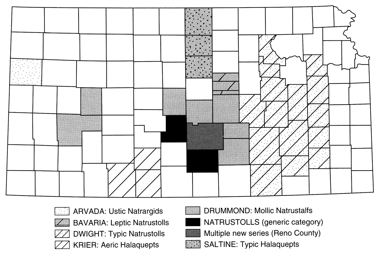
Sodic soils are often most readily identified from their classification in the current system of Soil Taxonomy (Soil Survey Staff, 1975). The prefix Natr at the great group level of this classification system indicates the presence of a natric horizon, which by definition is an argillic horizon, characterized by illuviation (the accumulation of clay and other colloidal particles) as well as a concentration of sodium (Soil Survey Division Staff, 1994). In Kansas, there are four soil series classified with a natric horizon in currently published soil surveys (table 1; fig. 1); and also a great group name of Natrustolls is used for a mapping unit name in two Kansas counties. In addition, a number of new natric soil series will result from revision of the Soil Survey of Reno County, currently in progress. It is anticipated that eventually most, if not all, map units of the Drummond series in Kansas, as well as the various slickspot complexes (discussed later), will be replaced by soil series having a natric horizon (C. E. Watts, personal communication, 1995).
Table 1—Sodium-affected soil series identified from classification.
| Natric Soil Series | Classification | |
|---|---|---|
| (existing series in published soil surveys) | ||
| Arvada | fine, montmorillonitic, mesic | Ustic Natrargids |
| Bavaria | fine, montmorillonitic, mesic | Leptic Narustolls |
| Drummond | fine, mixed, thermic | Mollie Natrustalfs |
| Dwight | fine, montmorillonitic, mesic | Typic Natrustolls |
| Natrustolls | generic category (see table 3 for recorrelations) | |
| Slickspots | unclassified (see table 3 for recorrelations) | |
| (potential new series for future soil surveys) | ||
| Abbyville | fine-loamy, mixed, mesic | Aquic Natrustalfs |
| Buhler | fine, mixed, mesic | Leptic Natrustolls |
| Darlow | fine-loamy, mixed, mesic | Vertic Natrustalfs |
| Elmer | fine-loamy, mixed, mesic | Typic Natrustolls |
| Kisiwa | fine-loamy, mixed, mesic | Typic Natraquolls |
| Punkin | fine, mixed, mesic | Aquic Natrustolls |
| Halaquept Soil Series | Classification | |
| Krier | fine-loamy, mixed, mesic | Aerie Halaquepts |
| Saltine | fine-silty, mixed (calcareous), mesic | Typic Halaquepts |
Figure 1—Natric and halaquept soil series.
Fifteen of the earliest soil surveys in Kansas, dating from 1960 to 1966, still used the 1949 soil-classification system. This older system is not as useful in identifying specific characteristics of a soil, such as morphology, or chemical and physical properties. It is based more on assumptions about soil genesis than it is on measurable properties. Of the 15 counties, only two contained any of the soil series later classified with a natric horizon. In the old Soil Survey of Geary County (Bidwell, 1960, which will be replaced by a new one, completed but not yet issued), the Dwight series was classified as a Planosol, providing no indication of the presence of sodium or a natric horizon, because there are other, non-sodic soils that also can be classified as Planosols. In Finney County, the Drummond series was classified as a "solodized Solonetz." Here and henceforth, individual county soil surveys are referred to only by the county name and not referenced individually. The term solonetz usually does infer a characteristic morphology, as well as saline-sodic chemical properties (Kelley and Shaw, 1935; Kelley, 1951; Westin, 1953), and solonetzic soils generally can be equated with natric soils. The term represents one stage in a genetic sequence from solonchak to solonetz to solod, a hypothetical progression through various stages of saline-sodic soil development (Kellogg, 1934; Joffe, 1949; Whittig, 1959). These terms are inexact with regard to morphology and specific chemical and physical properties, however, and imply a theory of genesis which may not be truly applicable in many, if not most, occurrences of natric soil.
The traditional theory of solonetz development relies on an initial stage of salinization (solonchak), typically from a high water table. Development of the solonetz occurs "when drainage improves under natural conditions" allowing for increased leaching of soluble salts without a corresponding displacement of adsorbed sodium (Soil Survey Division Staff, 1993). Continued leaching eventually removes the sodium, leaving the soil in a degraded condition (solod). Some of the more recent studies still cite perched or high water tables, or flooding, ponding, and desiccation as important factors (Lewis and Drew, 1973; Lavado and Taboada, 1988). However, most propose mechanisms for concentration of sodium, and the subsequent development of a natric horizon (i.e., solonetz morphology), without a prior stage of salinization and often in absence of a high water table, relying instead on minor differences in permeability and drainage and lateral subsurface movement of saline-soil solution instead of capillary rise (Wilding et al., 1963; Munn and Boehm, 1983; Reid et al., 1993). Likewise, while salt-affected soils traditionally have been associated only with arid or semiarid environments (Joffe, 1949; USDA, 1954), occurrences of solonetzic soils have been studied that cannot be explained in terms of previously arid climatic conditions (Fehrenbacher et al., 1963; Horn et al., 1964; Pettry et al., 1981). Establishing whether a particular occurrence is actively forming in the present environment or is a relict of past conditions, arid or otherwise, is important.
Table 2—Soil series in Kansas that are saline, sodic, saline-sodic, or may be affected by sodium or salinity to at least some degree (other than those already identified from classification; see table 1).
| Other Potentially Saline or Sodic Series | Slight Affected Series | ||||
|---|---|---|---|---|---|
| Brewer | EC 0-8 | SAR 0-7 | Bankard | EC 0-2 | SAR 0-5 |
| Buttermilk | EC 4-16 | no data | Brazilton | EC 0-4 | SAR 0-0 |
| Caruso (1) | EC 4-16 | SAR 0-0 | Caruso (2) | EC 0-4 | SAR 0-0 |
| Clairemont | EC 4-16 | SAR 2-13 | Clairemont (2) | no data | SAR 0-4 |
| Elkader | EC 2-16 | (Wallace) | Gerlane | EC 0-4 | no data |
| Kanorado (new) | EC 4-8 | SAR 3-6 | Gibbon | EC 0-2 | SAR 0-5 |
| Kim | EC <8 | (Wallace) | Haxtun | EC 0-2 | SAR 0-5 |
| Knoco | EC 0-0 | SAR 5-26 | Irwin | EC 2-4 | SAR 2-8 |
| Konza (new) | EC 2-8 | SAR 8-12 | Kenoma | EC 0-4 | SAR 0-0 |
| Las variant | EC 2-8 | no data | Kim | EC 0-4 | no data |
| Las Animas (1) | EC 4-16 | SAR 1-5 | Kingman | EC 0-4 | SAR 0-0 |
| Lebsack | EC 2-8 | SAR 0-0 | Las | EC 0-4 | SAR 0-0 |
| Lesho (1) | EC 4-16 | no data | Las Animas (2) | EC 0-4 | no data |
| Limon (1) | EC 2-8 | SAR 0-5 | Lesho (2) | EC 0-4 | SAR 0-2 |
| Limon (2) | EC 2-8 | SAR 15-30 | Manvel | EC 2-4 | SAR 0-5 |
| Mangum | EC 0-8 | SAR 0-0 | Mento | EC <4 | (several counties) |
| Mento | EC 2-8 | SAR 4-12 | Munjor | EC 2-4 | (Sheridan) |
| Midway | EC 2-8 | SAR 1-15 | Otero | EC 0-4 | SAR 0-0 |
| Minnequa | EC 0-8 | SAR 0-13 | Richfield | EC 2-4 | SAR 0-0 |
| Ninnescah (new) | EC 4-8 | SAR 1-5 | Ulysses | EC 0-0 | SAR 0-2 |
| Owens | EC 2-8 | SAR 2-6 | Vona | EC 0-4 | SAR 0-0 |
| Razor | EC 8-32 | SAR 10-15 | Wagonbed (new) | EC 0-1 | SAR 0-5 |
| Tamaha | EC 4-16 | no data | Wann | EC 0-2 | SAR 0-10 |
| Vernon | EC 2-8 | SAR 10-25 | Wellsford | EC 0-2 | SAR 2-8 |
| Waurika | EC 0-8 | SAR 0-0 | Zenda | EC <4 | (several counties) |
| NOTES: Values provided for EC and SAR are the ranges possible within that horizon which is most strongly affected; they are provided as given on the SIR for the series, except where reference to counties is given in parentheses, in which case the values have been provided from a specific soil survey in which they differ significantly from those on the SIR, or were not available from the SIR. Numbers in parentheses following soil series names indicate different variants of a series with the same name, but with different EC and SAR values associated with each variant. Some of these variants are similarly referenced in table 3. Soil series designated as new will not be found in any currently published soil survey. |
|||||
In Kansas, natric, solonetzic, or other sodium-affected soils are found in a diverse range of parent materials, landscape positions, and moisture regimes. While most of these soils are found in alluvial deposits on terrace and lowland settings, the Dwight series is found on uplands of the Flint Hills in the eastern third of the state. The Mento series, a sodium-affected soil which lacks a natric horizon, is found on loess-mantled uplands in north-central Kansas, often in complexes with the Harney series. And while some of the new natric-soil series proposed for the southcentral part of the state are classified in an aquic-moisture regime, the Arvada series in western Kansas, being an aridisol, has more of the character of a desert soil. Kansas straddles the transition zone from humid to subhumid climatic conditions, and natric or other sodium-affected soils may be found on either side of that transition.
Based on acreage figures given in the currently published soil surveys, almost 400,000 acres of natric soils exist in 26 Kansas counties (fig. 1). Of this amount, over 80% is Dwight, about 14% is Drummond, and 4% are the great group Natrustolls, while the Arvada and Bavaria together make up only about 1%. Natric soils are often associated with other, non-natric soil series in a complex, because they "occur as areas so intricately mixed or so small that mapping them separately is not practical" (this is the standard for all complexes in soil-survey reports). Percentages for each constituent soil series involved in a complex are provided in the map-unit descriptions for these complexes. Only those portions of these complexes that consist of affected soils are included in the acreage amounts given in this paper.
In the currently published soil surveys, no more than one natric soil series is recognized and mapped within any single county, but this will change once the revised Soil Survey of Reno County is issued. Another change that results from revision of the Soil Survey of Geary County is the replacement of the Dwight series in that county by the new Konza series. This change resulted from the realization that soils previously mapped as Dwight in Geary County, though affected by sodium, do not actually meet the full requirements for classification as the Dwight series. Some of these soils have sodium saturations exceeding 15%, but it is too deep in the soil to meet natric requirements. Others are marginal with 12-14% sodium saturation. The previous mapping was an example of adapting an existing series to fit what was found in the field so as to avoid defining a new soil series and reflects differences in soil-mapping philosophy. It is possible that a similar situation exists with the Dwight series in other counties.
Another category of sodic soils, identified by the prefix Hal at the Great Group level, contains enough sodium concentrated within the upper 50 cm of the surface to be considered salt affected, but does not have a natric horizon. Again, SAR must equal or exceed 13 (Soil Survey Division Staff, 1994). The only Great Group in the current version of Soil Taxonomy to use the Hal formative element is the Halaquepts. There are two soil series in Kansas classified as Halaquepts: the Krier series and the Saltine series. There are less than 10,000 acres of the Krier, and only 2,000 acres of the Saltine, in six counties (fig. 1), with an additional three counties in which other map units have been recorrelated to these two Halaquepts (table 3).
In revising the Soil Survey of Reno County, a miscellaneous mapping unit called "Slickspots" will be replaced by a number of new natric soil series. Clearly, the term slickspot in older soil surveys is another indication of the possible presence of natric or sodic soils, and it is a term that has been common in the literature on solonetzic soils. There are eleven other counties in Kansas, in addition to Reno County, which contain similar slickspot complexes (fig. 2a). Only three of these 11 counties also contain any of the previously described natric soil series. However, with few exceptions, these slickspot complexes have been recorrelated to the Drummond or Dwight series.
Figure 2A—Slickspot complexes.
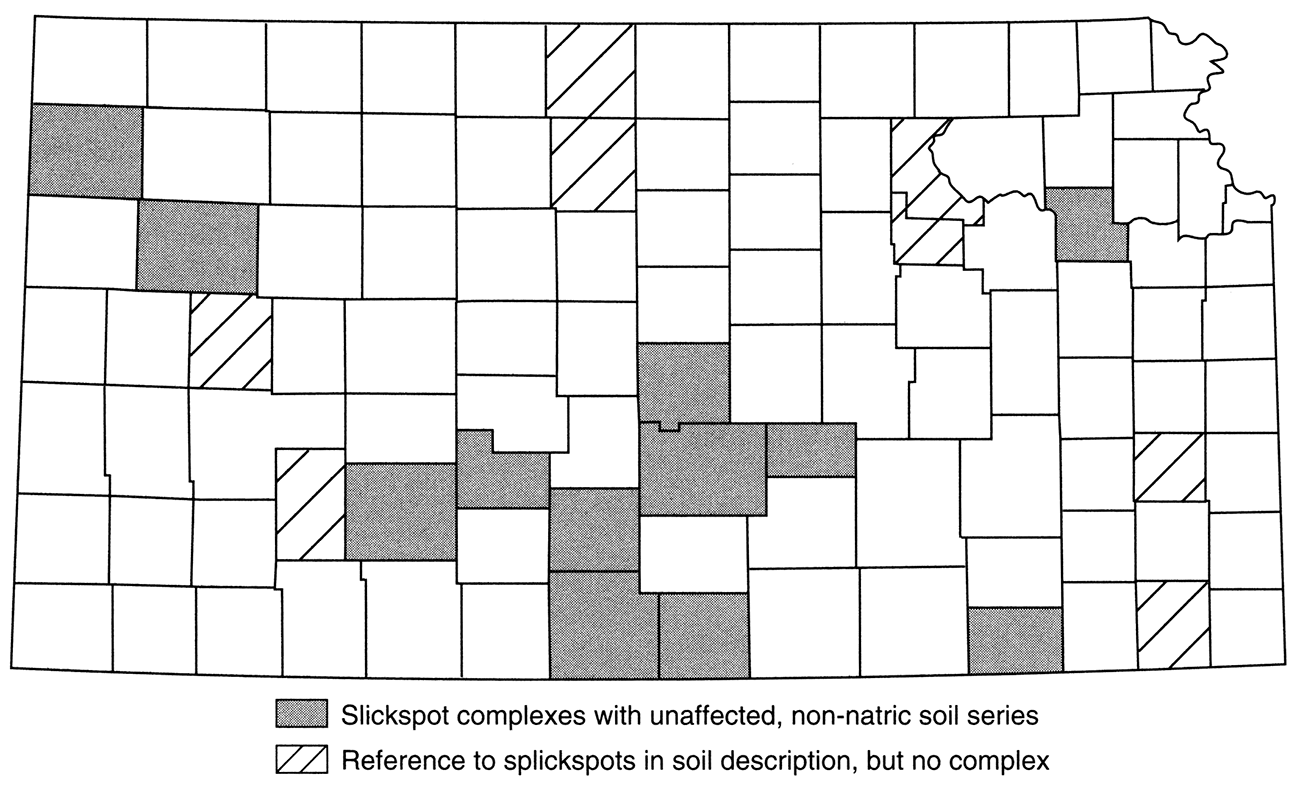
As defined in the glossaries of those soil surveys that contain them, slickspots are "small areas in a field that are slick when wet because they contain excess exchangeable sodium, or alkali" (Soil Survey of Harper County, 1971); or alternatively, a slickspot is defined as "a small area of soil having a puddled, crusted, or smooth surface and an excess of exchangeable sodium is generally silty or clayey, is slippery when wet, and is low in productivity" (Soil Survey of Mitchell County, 1980). Although there is a clear reference to sodium in both definitions, use of the term slickspot is no longer allowed under present NRCS mapping standards. The inexactness of classification associated with the term, and the wide variety of landscape features to which it can be applied, including those which have been generated locally in some older oil fields as a result of leaks and spills of subsurface brine associated with oil drilling and production, and past practices of disposal in surface ponds (Jones, 1986) have led to abandonment of the term. Slickspot complexes are found only in the older soil surveys, while the newer soil surveys rarely mention the term.
Almost 120,000 acres of slickspot complexes are shown in currently published soil surveys in Kansas, including Reno County. As with the complexes of natric-soil series described earlier, however, only a percentage of the total complex consists of slickspots. Based on percentages given in map-unit descriptions in the soil surveys, fewer than 50,000 acres of slickspot soil are represented by these complexes. About half of this acreage is located in Reno County. References to slickspots within soil descriptions occur in the soil surveys of an additional eight counties. Only two of these eight counties were previously identified as containing natric-soil series or slickspot complexes (fig. 2a).
Table 3—Selected recorrelatlons of map units to other soil series.
| MU | Name or Component | County | Recorrelation |
|---|---|---|---|
| As | Alluvial Land, Saline | BARBER | Clairemont (1) |
| Ah | Alluvial Land, Wet | CLOUD | Saltine |
| Ad | Alluvial Land, Wet | ELLIS | Caruso |
| Sa | Saline Alluvial Land | HARPER | Lesho (1) |
| Wa | Wet Alluvial Land | HARPER | Kingman |
| Wd | Wet Alluvial Land | PRATI | Kingman |
| Wa | Wet Alluvial Land | REPUBLIC | Saltine |
| —— | Bowdoin | HAMILTON | Las Variant |
| Bd | Bowdoin | KEARNY | Las Variant |
| Bo | Brazos | HARPER | Gerlane |
| —— | Church | several | Lebsack |
| Hg | Humbarger-Glenberg complex | GRANT | Las Animas (1) |
| Kz | Kanza soils | MEADE | Krier |
| Lg | Las Animas | KEARNY | Las |
| Lt | Leshara | FORD | Lesho (2) |
| Le | Leshara | GRAY | Lesho (2) |
| Ln | Lismas | FINNEY | Midway |
| Lm | Lismas | LOGAN | Midway |
| Mn | Minnequa | LOGAN | Manvel |
| Nu | N atrustolls | STAFFORD | Drummond |
| Ff | Farnum-Natrustolls complex | KINGMAN | Drummond |
| Za | Zenda-Natrustolls complex | STAFFORD | Drummond |
| —— | Owens | several | Wellsford |
| Pc | Promise | FINNEY | Limon (2) |
| Pt | Promise | LOGAN | Razor |
| Pr | Promise | LOGAN | Limon (1) |
| Ps | Promise | LOGAN | Limon (1) |
| Rb | Randall | SCOTI | Limon (1) |
| Rb | Richfield | MORTON | Haxtun* |
| Rb | Richfield | STEVENS | Haxtun* |
| Rb | Rough Broken Land | BARBER | Knoco |
| Rh | Rough Broken Land | SHERMAN | Kim |
| —— | Slickspots | several | Drummond, Dwight |
| As | Alluvial Land (Lesho) & Slickspots | FORD | slickspots unknown |
| Bs | Bridgeport-Slickspots complex | SHERMAN | Arvada |
| Vs | Volin-Slickspots complex | LOGAN | Arvada |
| Pk | Port-Slickspots complex | BARBER | Buttermilk |
| Pk | Port-Slickspots complex | HARPER | Buttermilk |
| Ve | Vernon soils | RENO | Wellsford |
| Rv | Renfrow-Vernon | RENO | Wellsford (Vernon) |
| Vs | Vernon-Shale outcrop | BARBER | Knoco (shale outcrop) |
| NOTE: Number in parentheses following soil series name (when present) corresponds to the number in parentheses in table 2 indicating the variant of a particular series to which the may unit has been recorrelated. *There are no map units of the Haxtun series in Kansas. However, the data on the SIR for the Haxtun apply to these Richfield map units. |
|||
Other than taxonomic classification and use of the term slickspot, the only other indications of sodium in soils provided in the soil surveys published by the NRCS are the occasional references in various columns of the interpretations tables to excess sodium or excess alkali, as well as to excess salinity. Such references are inconsistent and unpredictable, because these data are often lacking where they are most expected, even for soils with known salinity or sodicity. For example, references to excess salinity or excess sodium may be found in columns headed "Drainage" or "Grassed Waterways," or even in one case "Highway Location" (Mento series, Soil Survey of Osborne County, 1977), but not in the column headed "Irrigation"; or the only notation for affected soils may be simply "Not Applicable" or "No Interpretations Made; Properties Too Variable." Only rarely are values for ESP or SAR given anywhere in a soil survey, and usually only in the description of a particular soil series or soil-mapping unit.
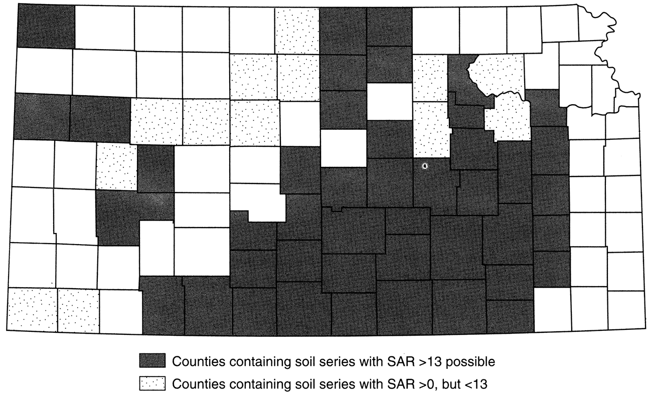
Only the Mento series was identified as a sodium-affected soil from references in the interpretations tables or soil descriptions. However, a number of other soils in Kansas may be affected by sodium to some degree. These other soils were identified from data on the SIRs for the series rather than from references to sodium in one of the soil surveys. Some of these, including the Vernon, Razor, and one variant of the Limon series, can classify as sodic, while others may be only slightly affected (table 2). Using only the SAR data on SIRs, almost 1.7 million acres of soils in 39 counties are identified as potentially at least slightly affected by sodium (with SAR given as "0-4" or greater). Of this amount, only about 150,000 acres in seven counties can have an SAR of 13 or greater, while more than one million acres in 11 counties consist of the Irwin series alone, which is only slightly affected. These figures do not include any of the Natric soil series, Halaquepts, or slickspot complexes already identified (including recorrelations), but they do include 14 counties that do not also contain one or more of these previously identified soils (fig. 2b).
Figure 2B—Soils affected by sodium (based on SAR).
The most reliable indicator of salinity in published soil surveys is a column in the table of physical and chemical properties that provides EC measurements in mmho/cm for all the soils in the county. However, these data are provided only in the newer soil surveys. Currently, a total of 51 counties (almost half) in Kansas have soil surveys which provide EC data in this table. In addition, three of the oldest soil surveys (for Finney, Ford, and Kearny counties) include a salinity column in the table of estimated engineering properties of the soils in which the salinity information is verbal rather than in numerical form, with an estimated range of EC values given for each verbal descriptor:
| Salinity | mmho/cm |
|---|---|
| none | 0-2 |
| slight | 2-4 |
| moderate | 4-8 |
| severe | 8-16 |
| very severe | > 16 |
| (Soil Survey of Kearny County, 1963) | |
For the majority of soils in those soil surveys that provide these data, EC is given as < 2 mmho/cm. Because this value appears to be the norm for the majority of soils, and because it corresponds to the verbal descriptor of "none" in the table above, any soil listed with EC values greater than 2 mmho/cm was noted as slightly affected by salinity and included in table 2, even though an EC of greater than 4 mmho/cm is necessary to classify a soil as saline. This interpretation included soils listed with EC given simply as < 4 mmho/cm under the assumption that if an EC of greater than 2 mmho/cm were not possible or likely, EC would have been given as < 2 mmho/cm along with the other unaffected soils.
Technically, from an agricultural perspective, EC must be greater than 8 mmho/cm before the soil is considered to have any real salinity problem (C.E. Watts, personal communication, 1995), so there is considerable latitude in interpretation possible as to what constitutes an affected soil. Jacobs and Whitney (1975) provide a summary, in diagrammatic form, of water-quality values plotted for soils of various textures that describe the close association of the EC of irrigation water to soils EC and potential hazards to crop production. This publication helps in the visualization of the water quality/salinity hazard in soils, but does not eliminate the ambiguity of what constitutes an affected soil.
Based on EC data provided on the SIR for each soil series in the state, 55 counties contain a total of more than 900,000 acres of soils that qualify as saline with EC values greater than 4 mmho/cm, including 23 counties with over 100,000 acres of soils with EC greater than 8 mmho/cm (fig. 3a). Of these same 55 counties, 42 also contain soil series for which EC may be greater than 2 mmho/cm, but not greater than 4 mmho/cm; and there are an additional 27 counties which contain "only" soils that fall within this lower range of EC values, making a total of 69 counties containing another five million plus acres which may be only slightly affected by salinity. In 18 of these latter counties, there is only one soil series in the county that is identified as slightly affected. Of these, the Brazilton series in Cherokee County is a special case, since this soil has been excavated and mechanically redeposited, and is therefore no longer a strictly natural soil. There are only 650 acres of the Brazilton, however (in Cherokee and Labette counties together), so it is an inconsequential exception.
Figure 3A—Soils affected by salinity (from EC data on SIRs).
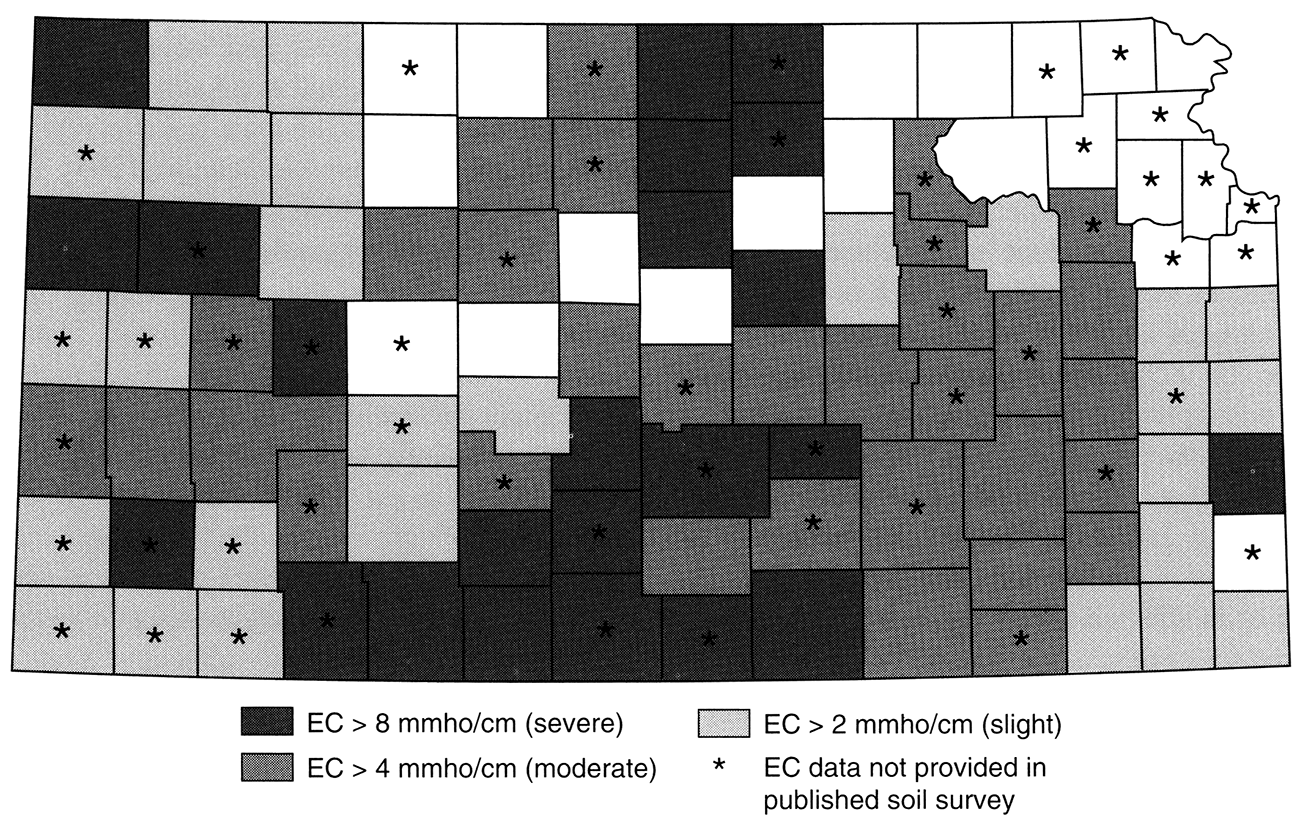
Of greater significance is the inclusion of the Kenoma and Richfield series among the soils that may be slightly affected by salinity. These two series deserve special consideration because of the considerable acreage they represent. The Kenoma comprises almost one million acres in 17 eastern Kansas counties (seven counties in which it is the only affected series identified); and the Richfield comprises nearly 2.5 million acres in 18 western Kansas counties. Portions of mapping units for each of these series can have EC values of up to 4 mmho/cm at the base of the sampled profile (60 inches deep). However, nothing in the classification, description, or interpretations of either series suggests salinity or sodicity; and reference to slickspots associated with the Kenoma appears in only two counties. They are included as affected soils because of the EC data, but they are not saline soils and probably should not be thought of as affected in any real sense. Other slightly affected series of lesser extent included in table 2 may be similar in this regard.
As a general rule, soils that have been identified as affected by sodium or salinity from other information or references in a given soil survey will have EC values that exceed 2 mmho/cm, if not 4 mmho/cm, when the data are provided. In addition, EC data frequently will identify soils which are not identified by any other references. This circumstance confirms the value of EC data compared to the other sources of information about salinity or sodicity available from the published soil surveys and demonstrates the need to include it in all soil surveys.
Another easily assessed indication of the presence of salinity provided in most soil surveys of Kansas counties is the range-site name assigned to each soil-map unit in the county. These names are provided in the Guide to Mapping Units (older surveys), or in the Range Productivity and Composition table (newer surveys). The notation that "only the soils that support rangeland vegetation are listed" suggests the possibility that some soils in the county might not be included. However, in those soil surveys in Kansas that include this information, the listing appears to be complete. There are only seven counties, mainly in the northeast corner of Kansas, for which the soil survey did not provide a classification of soils into range sites (fig. 3b). For these seven counties, soil surveys provide only woodland-management information, presumably because range is not an important land use in these counties.
Figure 3B—Counties with soil series in saline range sites.
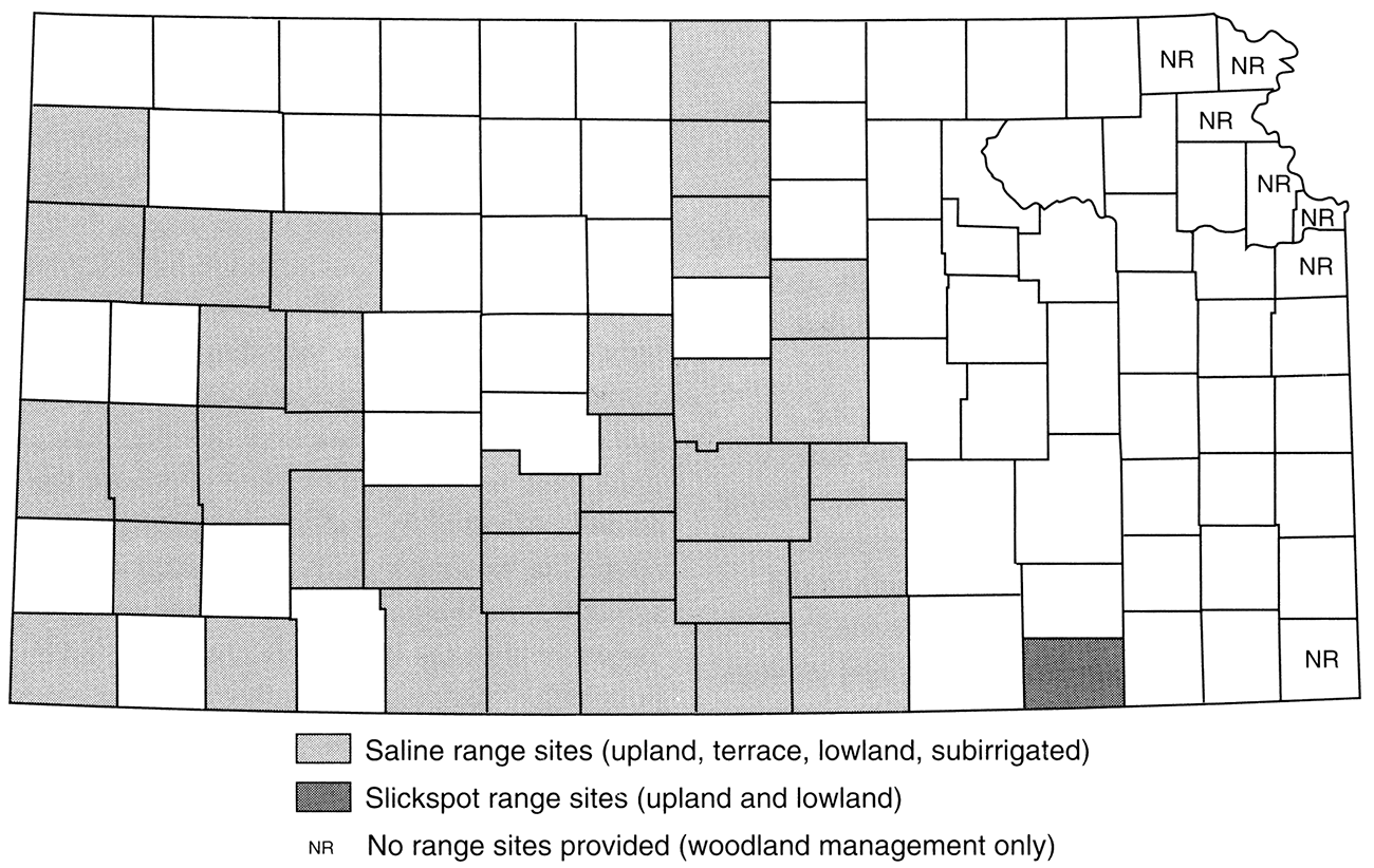
Range-site names in the published soil surveys that suggest salinity in soils include Saline Upland, Saline Terrace, Saline Lowland, and Saline Subirrigated, although only the Saline Lowland and Saline Subirrigated range sites are now used in the State Soil Survey Data Base (C. E. Watts, personal communication, 1995). However, in those soil surveys which identify soil salinity in other ways (with EC data, for example), the term "saline" mayor may not be in the name of the associated range site. For example, Loamy Terrace, Subirrigated, Sandy Lowland, Clay Lowland, and Clay Upland are all names of range sites applied to soil-map units which may be affected by sodium or salinity to some degree; and Claypan is the range site assigned to the Dwight series, which is one of the natric soils previously identified. Also, saline rangesite names do not provide any measure of severity. Soils classified into saline range sites may be severely affected, or they may be only slightly affected. In one case (the Caruso series, in Gove County), the Saline Sub irrigated range site is assigned to the map unit even though EC is given as < 2 mmho/cm. In Chautauqua County, "Slickspot" range sites are specified for the slickspot complexes in that county, while in other counties a saline range site is typically assigned to slickspot complexes.
Thirty-five counties in Kansas contain a total of almost 320,000 acres of soil-map units classified into saline range sites, including the slickspot-range sites of Chautauqua County (fig. 3b). This total includes most of the soils already identified from natric classification or reference to slickspots, however. The natric and slickspot soils are commonly assigned saline range sites to match the other evidence of salinity or sodicity for those soils. The one most notable exception is the Dwight series, with its Claypan range-site name. On the other hand, there are a few map units with saline range-site names in various counties that involve soil series which, from data on their SIRs, are normally considered to be completely unaffected by sodium or salinity. The range-site name is the only indication that the map unit may be affected in any way. Some of these map units have been recorrelated to other soil series (table 3). However, in other cases such map units have not been recorrelated because the soils are not actually affected by sodium or salinity. Apparently, the range site was incorrectly designated in the soil survey as saline (C. E. Watts, personal communication, 1995). Together with the other deficiencies noted earlier, this possibility suggests that saline range-site names may not be a very dependable indicator of salinity in soils.
Of the 105 counties in Kansas, 67 were identified from information in the published soil surveys as containing soils that are or could be affected by sodium or salinity. The soil surveys of 22 of the remaining 38 counties did not provide EC data, while none of the 38 contained any other references to indicate the presence of salt- or sodium-affected soils in those counties. Although it is probable that counties in the glaciated northeast corner of the state truly do not contain any affected soils, additional information from outside of the published soil surveys (ie., SIRs and the NRCS State Soil Survey Data Base) helped identify several other soils that are at least slightly affected by sodium or salinity in an additional 17 counties whose soil surveys did not indicate the presence of affected soils. Thus, it appears that not all of the published soil surveys (the older ones in particular) provide the necessary means for a complete evaluation of salinity and sodicity in Kansas soils. Nevertheless, even without additional information, the review of published soil surveys alone suggests a distribution of affected soils which is more widespread than originally thought in the state of Kansas. With the additional information, a total of 84 counties were identified that contain at least one soil series that is affected by salinity or sodium to some degree (fig. 4).
Figure 4—Counties with soil series affected by salinity and/or sodicity.
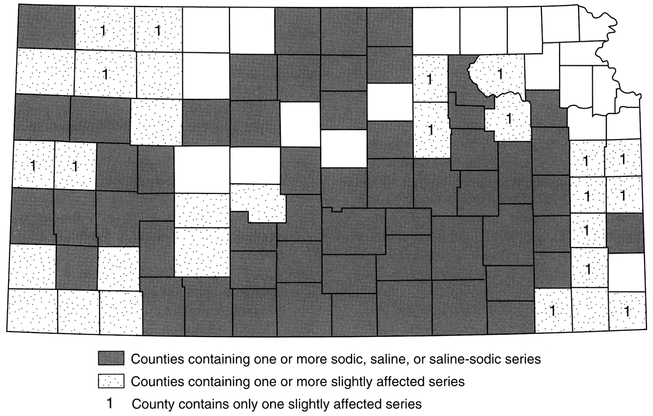
The 84 counties identified contain a total of almost 7.2 million acres of map units involving soils that may be at least slightly affected by sodium or salinity. However, many of these soil-map units are complexes involving both affected and unaffected soils. The actual acreage of affected soil within a given map unit of such a complex is some percentage of its total. Based on the percentage figures provided in the soil surveys for these complexes, a total of more than 6.3 million acres of soils may be actually affected to some degree, constituting almost 15% of the 84 counties in which they are found, or 12% of the entire state. Of this total, 84% comprises soils identified as only slightly affected, with EC values in the range between 2 and 4 mmho/cm or an SAR greater than zero but less than 13; and 71% of this total consists of just three soil series (Richfield, Kenoma, and Irwin). Discounting all the soils that are only slightly affected leaves just over one million acres of soils in 55 Kansas counties (less than 2% of the total area of the state) that are actually affected by sodium or salinity to a degree great enough to be classified as saline, sodic, or saline-sodic, based on the definitions cited earlier.
The variations in climate, landscape position, and parent materials among the various soils affected suggest that there are factors other than these involved in concentrating salts or sodium in soils. Nevertheless, although salt marshes, salt deposits, and salinity in Permian rocks, ground water, and surface flow have been long recognized in many of the locations that contain these affected soils, conclusive evidence is lacking to identify a specific local source of salinity to explain each occurrence of affected soil. Moreover, it has been demonstrated that a great level of salinity in the environment is not necessary for an accumulation of salts to occur from evapotranspiration (Don Whittemore, personal communication, 1995). Most likely, many occurrences of affected soils are the result of a combination of factors acting upon a generally widespread presence of at least slight levels of salinity throughout the environment. Debate continues on theories for explaining why some areas are affected while others in the same general area are not. However, the configuration of the landscape and related geomorphic factors affecting permeability and drainage may play the most important role in determining where salts accumulate.
In terms of land use, the widespread distribution illustrated by this review suggests the need for greater sensitivity to the possibility of both existing and potential occurrences of salinity- or sodium-affected soils throughout much of Kansas, including areas in which one would not normally expect such problems. Clearly, salinity and sodicity are factors requiring consideration in the development and use of Kansas landscapes. While there are amelioration techniques that may improve the condition of these soils, incomplete understanding of all the factors that contribute to how and why salinity or sodium accumulates in certain locations but not in others argues for greater acceptance of natural occurrences as areas that are unfavorable for some uses until further research toward answering these questions is completed. Relatively minor human modifications to the landscape that affect drainage can bring about the development of new occurrences of salt accumulation in soil, even without the introduction of a new or increased source of salinity in the area (Whittemore, 1995). Such instances demonstrate that sometimes the best of intentions can lead to unexpected results. Existing areas of affected soils that derive their saline or sodic character primarily from natural causes could be prime candidates for the Conservation Reserve Program (CRP), ensuring that existing natural conditions are not exacerbated through unnecessary and undesirable use. Moreover, the condition of affected soils removed from cultivation or extensive grazing should be studied over time and documented to determine whether or not improvement results from their removal from production, and to assess the benefit of the CRP. Where yields are already lower than they would be in a completely unaffected area, such an assessment could lead to better land management.
We would like to acknowledge the assistance of Cleveland Watts, Assistant State Soil Scientist, Natural Resource Conservation Service, Salina, Kansas, for providing information from the NRCS data base and for patiently answering innumerable questions on the telephone; and also, for the patience and helpfulness of all other NRCS soil scientists with whom we spoke on the telephone and in the field. We would also like to acknowledge the valuable input of Don Whittemore, Senior Scientist and Geohydrology Section Chief, Kansas Geological Survey.
Bidwell, O. W., 1960, Soil survey of Geary County, Kansas: U.S. Department of Agriculture, Soil Conservation Service. U.S. Government Printing Office, Washington
Brady, N. C., 1990, The nature and properties of soils: New York, Macmillan
Bresler, E., McNeal, B. L., and Carter, D. L., 1982, Saline and sodic soils—principles-dynamics-modeling: Berlin, Springer-Verlag
Fehrenbacher, J. B., Wilding, L. P., Odell, R. T., and Melsted, S. W., 1963, Characteristics of solonetz soils in Illinois: Soil Science Society of America, Proceedings, v. 27, p. 421-431
Glazovskaya, M. A., 1972, Soils of the world, volume 1—soil families and soil types: Moscow University Publishers
Gupta, R. K., Bhumbla, D. K., and Abrol, I. P., 1984, Effect of sodicity, pH, organic matter, and calcium carbonate on the dispersion behavior of soils: Soil Science, v. 137, p. 245-251
Horn, M. E., Rutledge, E. M., Dean, H. C., and Lawson, M., 1964, Classification and genesis of some solonetz (sodic) soils in eastern Arkansas: Soil Science Society of America, Proceedings, v. 28, p. 688-692
Jacobs, H. S., and Whitney, D. A., 1975, Determining water quality for irrigation: Cooperative Extension Service, Kansas State University, Manhattan, Publication C-396 (revised)
Joffe, J. S., 1949, Pedology: Somerset Press
Jones, J. F., 1986, Soil salinity resulting from secondary oil recovery in Anderson County, Kansas—effects and reclamation efforts: M. A. thesis, University of Kansas, Department of Geography
Kelley, W. P., 1951, Alkali soil; their formation, properties and reclamation: New York, Reinhold Publishing Co.
Kelley, W. P., , 1962, Sodium carbonate and adsorbed sodium in semiarid soils: Soil Science, v. 94, p. 1-5
Kelley, W. P., and Shaw, C. F., 1935, The meaning of the term solonetz: American Soil Survey Association, Bulletin, v. 16, p. 1-3
Kellogg, C. E., 1934, Morphology and genesis of the solonetz soils of western North Dakota: Soil Science, v. 38, p. 483-501
Lavado, R. S., and Taboada, M. A., 1988, Water, salt, and sodium dynamics in a natraquoll in Argentina: Catena, v. 15, p. 577- 594
Lewis, D. T., and Drew, J. V., 1973, Slick spots in southeastern Nebraska—patterns and genesis: Soil Science Society of America, Proceedings, v. 37, p. 600-606
Munn, L. C., and Boehm, M. M., 1983, Soil genesis in a natrargid-haplargid complex in northern Montana: Soil Science Society of America, Journal, v. 47, p. 1,186-1,192
Nakayama, F. S., 1966, Deflocculation of soil materials by sodium salts: Soil Science, v. 102, p. 388-393
Pettry, D. E., Brent, F. V., Nash,V. E., and Koos, W. M., 1981, Properties of natraqualfs in the upper coastal plain of Mississippi: Soil Science Society of America, Journal, v. 45, p. 587-593
Reid, D. A., Graham, R. C., Southard, R. J., and Amrhein, C., 1993, Slickspot soil genesis in the Carrizo Plain, California: Soil Science Society of America, Journal, v. 57, p. 162-168
Soil Survey Division Staff, 1993, Soil survey manual: U.S. Department of Agriculture, Agriculture Handbook No. 18
Soil Survey Division Staff, 1994, Keys to soil taxonomy: U.S. Department of Agriculture, Soil Conservation Service, 6th edition
Soil Survey Staff, 1975, Soil taxonomy: U.S. Department of Agriculture, Soil Conservation Service, Agriculture Handbook No. 436
Soil Survey Staff, Kansas, 1960-1993, Soil surveys published for each county in Kansas: U.S. Department of Agriculture, Soil Conservation Service (cited in the text by county name)
U.S. Department of Agriculture (Salinity Laboratory Staff), 1954, Diagnosis and improvement of saline and alkali soils; in, U.S. Salinity Laboratory, Riverside, California, L. A. Richards, ed.: U.S. Department of Agriculture, Handbook No. 60
Westin, F. C., 1953, Solonetz soils in eastern South Dakota—their properties and genesis: Soil Science Society of America, Proceedings, v. 17, p. 287-293
Whittemore, D.O., 1995, Geochemical differentiation of oil and gas brine from other saltwater sources contaminating water resources-case studies from Kansas and Oklahoma: Environmental Geosciences, v. 2, p. 15-31
Whittig, L. D., 1959, Characteristics and genesis of a solodized-solonetz of California: Soil Science Society of America, Proceedings, v. 23, p. 469-473
Whittig, L. D., and Janitzky, P., 1963, Mechanisms of formation of sodium carbonate in soils: Journal of Soil Science, v. 14, p. 322-333
Wilding, L. D., Odell, R. T., Fehrenbacher, J. B., and Beavers, A. H., 1963, Source and distribution of sodium in solenetzic soils in Illinois: Soil Science Society of America, Proceedings, v. 27, p. 432-438
Adsorption—The bonding, usually temporary, of ions or compounds onto the surfaces of soil solids such as mineral or organic colloids.
Alkaline soil—Any soil that has a pH > 7.
Argillic horizon—A mineral-soil horizon characterized by the illuvial accumulation of layer-lattice silicate clays.
Cation exchange—The interchange between a cation in solution and another cation on the surface of any surface-active material such as clay or organic matter.
Colloids—Organic and inorganic matter with very small particle size and a correspondingly large surface area per unit mass, usually with an electrical charge.
Desalinization—Removal of salts from a saline soil, usually by leaching.
Dispersion/deflocculation—The breaking down of soil aggregates into individual particles. Generally, the more easily dispersed the soil, the more erodible it is.
Eluvial horizon—A soil layer or horizon from which soil material has been removed by solution or by suspension or both.
Electrical conductivity (EC)—A measure of the ability of the soil solution to carry an electrical current. The measure is used to estimate salt levels in soils. EC is expressed in millimhos per centimeter (mmho/cm) or decisiemens per meter (dS/m).
Exchangeable sodium percentage (ESP)—Identifies the degree to which the exchange complex in a soil is saturated with sodium.
ESP = (Exchangeable sodium [cmol/kg] / Cation exchange capacity [cmol/kg]) x 100
Illuvial horizon (soil)—A soil layer or horizon in which material carried from an overlying layer has been precipitated from solution or deposited from suspension.
Major Land Resource Area (MLRA)—The use of MLRAs by the Natural Resource Conservation Service is an attempt to survey and map soils on the basis of major landscape units, such as drainage basins, rather than by counties in order to minimize the effect of political boundaries on map delineations.
Natric horizon (soil)—A mineral-soil horizon that satisfies the requirements of an argillic horizon, but that also has prismatic, columnar, or blocky structure and a subhorizon having more than 15% saturation with exchangeable sodium.
Natural Resource Conservation Service—A branch of the U.S. Department of Agriculture charged with, among other things, soil survey and interpretation (formerly known as the Soil Conservation Service or SCS).
Planosol—A type of soil under the old (1949) soil-classification system in which soils were characterized by high clay content and developed on nearly flat or gently sloping uplands in humid or subhumid climates.
Salic horizon—A mineral-soil horizon of enrichment with secondary salts more soluble in cold water than gypsum. A salic horizon is 15 cm or more in thickness.
Saline soil—A nonsodic soil containing sufficient soluble salts to impair its productivity. The conductivity of a saturated extract is > 4 mmho/cm, the sodium adsorption ratio is < 15, and the pH is < 8.
Saline-sodic soil—A soil containing sufficient exchangeable sodium to interfere with the growth of most crop plants and containing appreciable quantities of soluble salts. The exchangeable sodium adsorption ratio is > 13, the conductivity of the saturation extract is > 4 mmho/cm, and the pH is usually 8.5 or less.
Sodic soil—A soil that contains sufficient sodium to interfere with the growth of most crop plants, and in which the sodium adsorption ratio is 13 or greater.
Sodium adsorption ratio (SAR)—Provides information on the comparative concentrations of Na+, Ca2+, and Mg2+ in soil solutions.
SAR = [Na+]/ √1/2([Ca2+] + [Mg2+])
Slickspot—Small areas of soil that are slick when moist because of a high content of exchangeable sodium.
Soil Interpretations Record (SIR)—The soil interpretations record is a part of the Soil Survey Data Base and provides detailed information on a soil's properties as well its suitability and/or limitations for a variety of uses. SIRs are also known as SOILS-5s.
Soil-map unit—A map unit is a collection of areas defined and named the same in terms of their soil components and/or characteristics. Each map unit differs in some respect from all others on the map.
Soil series—The soil series is the most homogenous category in the soil-classification system used in the United States. It is a group of soils that have horizons similar in arrangement and in differentiating characteristics and with a narrow range in sets of properties.
Soil Survey Data Base (national or state level)—All soil-survey data today are recorded using uniform criteria and format so that data entry and correlation are facilitated among areas and agencies.
Soil taxonomy—Synonomous with soil classification, Soil Taxonomy is the title of the soil-classification scheme published in 1975, but used in the United States for the last three decades. It consists of six major categories or levels including: orders, suborders, great groups, subgroups, families, and series. The terms used in this scheme are largely Greek and Latin roots combined to form mnemonic terms to describe soils according to their properties. Examples pertinent to this study at the great group level would be Natrargids, meaning dry soils enriched with clay and having a natric horizon, or Halaquepts, meaning poorly developed soils in wet settings with high ESP (> 15) or SAR (> 13) near the soil surface.
Solod, Soloth soil—A great soil group in the 1949 soil-classification system that includes saline or alkaline soils which have been subjected to leaching.
Solonchak—A great soil group in the 1949 soil-classification system consisting of soils with a salt crust on the surface and salts throughout the solum, formed in semiarid to arid climates under conditions of poor drainage.
Solonetz—A great soil group in the 1949 soil-classification system consisting of soils with a B horizon characterized by columnar structure and high alkalinity; formed under semiarid to arid climates under moderate to poor drainage conditions.
This glossary was compiled and modified from several sources, most notably Brady (1990).
Kansas Geological Survey
Placed on web July 11, 2017; originally published in 1997.
Comments to webadmin@kgs.ku.edu
The URL for this page is http://www.kgs.ku.edu/Publications/Bulletins/TS10/index.html