Kansas Geological Survey, Subsurface Geology Series 14, originally published in 1991
Originally published in 1991 as Kansas Geological Survey Subsurface Geology Series 14. This is, in general, the original text as published. The information has not been updated.
This study discusses the occurrence and distribution of the major basement rock types in the Joplin 1° x 2° quadrangle. The distribution of drill data used in the study, depth of penetration into the Precambrian, elevation with respect to sea level, and rock type encountered at the basement surface are shown on the accompanying map. Major structures are inferred from detailed structural contour maps using the top of the overlying Arbuckle Group of rocks and the Mississippian carbonates as datum planes. Aeromagnetic and derivative maps were used to locate major lineaments and to aid in the interpretation of basement rock where drill hole data are sparse. Faults and geophysical linear trends appear to be important in delineating geologic terranes. Regionally important structures include the northwest-trending Chesapeake, Bolivar-Mansfield, and Fall River tectonic zones. Structures parallel to, and including the Miami trough in Cherokee County, and those to the south of the Fredonia dome in Wilson County, constitute the major northeast-trending tectonic zones.
Epizonal granite is the predominant rock type in the Joplin quadrangle. Genetically closely related rhyolite covers major portions of the southern tier of counties south of the Fall River tectonic zone. Slightly metamorphosed, clastic, sedimentary rocks occur in fault-bounded basins or grabens mostly in the northeastern portion of the quadrangle.
This study and the accompanying map are part of a series of publications dealing with the geology, geochemistry, and geophysics of the Joplin 1° x 2° quadrangle, located in southeastern Kansas and southwestern Missouri. The data were collected as part of a multidisciplinary, cooperative effort by the Kansas and Missouri Geological Surveys, and the U.S. Geological Survey under the Conterminous United States Mineral Assessment Program (CUSMAP).
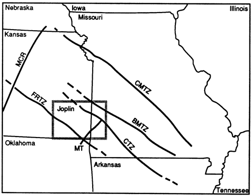
The Joplin 1° x 2° quadrangle covers an area of approximately 7,500 mi2 and is located in southeastern Kansas and southwestern Missouri between longitudes 94° and 96° West and latitudes 37° and 38° North (fig. 1). In southeast Kansas all or most of the following nine counties are included in the quadrangle: Cherokee, Crawford, Bourbon, Labette, Neosho, Allen, Montgomery, Wilson, and Woodson. Minor portions of three adjoining counties to the west also fall into the area. In Missouri all or most of Jasper, Barton, and Vernon and minor portions of surrounding counties are included.
Figure 1--Index map of the midcontinent area showing the location of the Joplin quadrangle, Midcontinent rift (MCR), Fall River tectonic zone (FRTZ), Bolivar-Mansfield tectonic zone (BNM), Chesapeake tectonic zone (CTZ), the Central Missouri tectonic zone (CMTZ), and the Miami trough (MT).
The map represents an attempt to interpret the Precambrian basement geology of the Joplin quadrangle from limited drill hole information (Cole and Watney, 1985; Dennison and others, 1984; Bickford and others, 1981; Kisvarsanyi, 1975; Dennison, 1966), from aeromagnetic and ground-based gravity data (Yarger, 1989; Lam, 1987), and from structures mapped in the overlying Paleozoic sedimentary rocks (Blair and others, in press).
Published geologic maps of the Precambrian basement rocks of Kansas (Bickford and others, 1979) and Missouri (Kisvarsanyi, 1979) show that granitic intrusive rocks and rhyolitic to dacitic volcanic rocks cover most of the Joplin quadrangle. The northern portion of the quadrangle in Kansas is shown to consist primarily of epizonal granite, often with abundant perthite and exhibiting granophyric textures. To the south rhyolitic and minor dacitic volcanic rocks dominate. Ash-flow tuffs and lava flows, some of which are believed to be closely related to the epizonal granites and have textures characteristic of those rocks, are common. The granitic and rhyolitic rocks range in age from 1,350 to 1,400 m.y., with ft most common age reported at 1,380 m.y. (Bickford and others, 1981; Thomas and others, 1984).
Rhyolitic rocks, similar to those described above, occur widespread in Vernon County, Missouri, in the northeast portion of the quadrangle (Kisvarsanyi, 1979). These rocks were not recognized on the Kansas side of the state line. Subvolcanic granite massifs consisting of alkali granite and some granophyre occur to the south in Barton and Jasper counties and may be correlative with the epizonal granites in Kansas. An area in southeast Barton and northeast Jasper counties is underlain by coarse-grained granite, some of which is two-mica granite, similar to rocks occurring in the St. Francois Mountains in southeast Missouri. Low-grade metamorphic clastics are recognized in western Vernon County and extend across the border into eastern Bourbon County, Kansas.
Undivided rhyolite, dacite, and epizonal granite underlies most of the Joplin quadrangle as shown on a Precambrian basement map of the northern midcontinent (Sims, 1990). This map shows epizonal, micrographic granite porphyry and granite, and mesozonal granite of similar age occurring to the east in Missouri. Early Proterozoic, mesozonal, granitoid rocks are shown near the northern border of the quadrangle. Sims (1990) also shows a confined area straddling the Kansas-Missouri border underlain by Middle Proterozoic (about 1,300 m.y.) low-grade metamorphic clastic sedimentary rocks.
Within the the Joplin quadrangle, 86 reported drill holes penetrate Precambrian basement rocks (table 1). A limited amount of core is available for study from five drill holes. Well cuttings from only about three dozen drill holes are archived at the Kansas Geological Survey, Wichita Well Sample Library, and the Missouri Department of Natural Resources, Geological Survey, Rolla. Identification of basement rock types from cuttings presents potential problems if the penetrations are shallow. Of the 86 drill holes that penetrate the basement complex, 30 have penetrations less than 20 ft (6.6 m), 19 greater than 100 ft (33 m), and only 10 penetrate deeper than 500 ft (156 m).
Our map (plate 1) shows the distribution of the 86 basement tests, the depth of penetration, and rock type encountered at the Precambrian basement surface. Of this total, 13 drill holes penetrate the Precambrian surface in the Missouri portion of the quadrangle. The best coverage of data is in the southwestern corner of the quadrangle. Most holes drilled into the Precambrian in Kansas are listed in Kansas Geological Survey Subsurface Geology Series 7 (Cole and Watney, 1985), which is current to 1981. Missouri basement data were gathered from Kisvarsanyi (1975). The location of more recently completed drill holes was obtained from regularly published well completion records. Other sources include geophysical logs and drillers' logs. Wells to the basement in Missouri are often completed as community water wells, while most of those in Kansas result from hydrocarbon exploration.
Well operators have provided many basement samples, which have been examined with a binocular microscope to verify or identify basement rock type. Thin sections have been prepared from cuttings and available core from about a half dozen drill holes. Detailed petrographic descriptions of individual drill holes have been published by Denison (1966). More general petrographic descriptions can be found in publications by Bickford mid others (1981,1979), Kisvarsanyi (1975, 1974), and Skillman (1948).
Identification of basement rock type encountered in the remaining drill holes is impossible to verify. Most of the rocks were identified at the well site by either a geologist or driller, whose ability to identify basement rocks varied widely with experience. Cuttings from a number of wells, some of which were drilled as early as 1908, may have existed at one time or another, but have since been lost
Table 1--Information from 86 wells penetrating the Precambrian drilled in the Joplin quadrangle area.
| Kansas County |
Operator | Lease | sec. | T | R | spot | Elevation | Datum | Rock Type | Penetration |
|---|---|---|---|---|---|---|---|---|---|---|
| Allen | Oklahoma PR | 1 Iola Test | 26 | 24S | 18 E | SW SW NE | 975' | -1182' | conglomerate | 1483' |
| Allen | Tenneco | 1 Olson | 14 | 25S | 19 E | NW NW NW | 1036' | -1089' | granite wash | 91' |
| Allen | unknown | 1 Dalton | 34 | 25S | 19 E | SE SE NW | 1025' | -1129 | granite | 57' |
| Allen | Gunby | 1 Bundy | 24 | 26S | 17 E | C NE NE | 948' | -1232' | granite | 225' |
| Bourbon | Perry | 1 Burney | 21 | 25S | 25 E | C SE | 820' | -8601 | metagraywacke | 130' |
| Bourbon | Equity | 1 Wiemer | 25 | 26S | 23 E | NW NW NW | 919' | -901 | "shale, sandstone" | 175' |
| Bourbon | Okla. Natural Gas | 1 Stevenson | 16 | 26S | 24 E | SW SW NE | 925' | -885' | phyllite & metasiltstone | 597' |
| Cherokee | Ackerd | 1 Harley | 30 | 31 S | 22 E | C SE NE | 859' | -983' | granite | 17' |
| Cherokee | McMillan | 1 Clark | 13 | 33S | 21 E | NE SE SE | 825' | -1081' | meta-arkose | 13' |
| Cherokee | City of Columbus | 4 Fee | 13 | 33S | 23 E | NE NW NE | 890' | -878' | granite | 12' |
| Cherokee | Glower | 1 Forkner | 17 | 33S | 23 E | NW SW SE | 897' | -933' | granite | 5' |
| Cherokee | Unknown | 13 Brugger | 34 | 34S | 24 E | SE SW NE | 810' | 539 | black granite ?? | ** |
| Cherokee | Kephart | 1 King | 4 | 35 S | 22 E | NW NE SW | 793' | -97- | rhyolite | 300'+ |
| Cherokee | Eagle Picher | 1 Brand | 11 | 35S | 23 E | SW NW NE SW | 841' | -875' | andesite | 130'* |
| Cherokee | Eagle Picher | 1 Kansas EX | 12 | 35S | 23 E | C NE NE | 853' | -1103' | andesite | 103'* |
| Cherokee | Eagle Picher | 1 Webber | 12 | 35S | 23 E | NE NE SE SE | 858' | -795' | rhyolite porphyry | 15'* |
| Cherokee | Eagle Picher | 1 Wilbur | 14 | 35S | 23 E | SW NW NE NE | 832' | -955' | trachyte | 90* |
| Chautauqua | Home | 1 Blecha | 5 | 32S | 13 E | NE SE SE | 988' | -1607 | granite | 1' |
| Chautauqua | McKenzie | 1 CarTa | 27 | 34S | 13 E | NE NE NW | 744' | -2069 | rhyolite | 5' |
| Crawford | LaSalle | 1 Gobl | 20 | 28S | 25 E | SE SE NW | 912' | -939 | granite | 20' |
| Elk | Kenny Cox | 1 Bryant | 33 | 31S | 13 E | NW NE SE | 1" | -1699 | metarhyolite | 11' |
| Greenwood | Lauck Oil | 1 Fee | 33 | 27S | 13 E | C NE SW | 1043' | -1255' | granite | 33' |
| Labette | Labette | 1 Bradford | 5 | 31S | 19 E | SW SW NE | 957' | -1198' | granite | 18' |
| Labette | Glore | 1 Wert | 17 | 31S | 21 E | C NE SE | 856' | -1039 | granite | 13' |
| Labette | Neosho Valley | 3 Wackerle | 1 | 35S | 19 E | C W2 W2 | 907' | -411' | andesitic basalt | 33' |
| Montgomery | Layton | 1 Grossman | 12 | 31S | 16 E | NE SE NW | 870' | -1484' | granite wash | 16' |
| Montgomery | Peaker | 1 Smith | 27 | 31S | 16 E | C NE SW | 809' | -1481' | granite | 1' |
| Montgomery | Frankfort | 1 Carter | 23 | 32S | 14 E | NE NE NW | 823' | -1582' | metarhyolite | 87' |
| Montgomery | Thompson-Hilt | 10 Springer | 28 | 32S | 14 E | SW SW SE | 881' | -1222' | rhyolite | 28' |
| Montgomery | Stevens | 1 Uitts | 7 | 32S | 16 E | C SE SE | 765' | -1569 | metarhyolite | 220' |
| Montgomery | Pittman | 1 Gressell | 8 | 32S | 16 E | NW SW SW | 765' | -1555' | arkose | 14' |
| Montgomery | Stevens Crisel | 1 Uitts | 18 | 32S | 16 E | NE NE NE | 760' | -1555' | rhyolite | 383' |
| Montgomery | Masek Oil | 1 Hay | 25 | 33S | 13 E | SE NE NW | 847' | -1983' | rhyolite | 47 |
| Montgomery | Hydraulic | 1 Beal | 12 | 33S | 14 E | SW SW NW | 875' | -1661' | granite | 5' |
| Montgomery | Consolidated | 1 Rail | 7 | 33S | 15 E | S2 S2 SW SE | 855' | -1689 | granite | 15' |
| Montgomery | White Eagle | 23 Rail | 32 | 33S | 15 E | SE SW SW NW | 790' | -1745' | granite | 29 |
| Montgomery | Hayes | 10 Cement Plant | 5 | 33S | 16 E | NWSWNE | 781' | -563' | metarhyolite | 10' |
| Montgomery | Goodbar | 1 Reece | 12 | 33S | 16 E | NW NW SE | 800' | -912' | metarhyolite | 5' |
| Montgomery | Illini Oil | 1 Reece | 12 | 33S | 16 E | SW SE NE | 809' | -948' | granite | 5' |
| Montgomery | Kaylee Oil | 8 Traxson | 3 | 33S | 17 E | SW NW SW | 739' | -1348' | rhyolite | 123' |
| Montgomery | Kathol | 3 Coleman | 4 | 33S | 17 E | NW NW SE | 752' | -782' | rhyolite | 28' |
| Montgomery | Brown | 1 Miller | 33 | 33S | 17 E | C NW NE | 740' | -1415' | granite | 5' |
| Montgomery | Empire | 1 Pocock | 11 | 34S | 13 E | E2 SW NE | 764' | -1936' | arkose | 129' |
| Montgomery | Masek Oil | 22-25G Watson | 25 | 34S | 13 E | E2 SE NW | 842' | -1916' | arkose | 607' |
| Montgomery | Masek Oil | 41-26G Crocker | 26 | 34S | 13 E | C NE NE | 766' | -1640' | granite | 170' |
| Montgomery | Frankfort | 1 Hadden-W | 4 | 34S | 15 E | C SE NE | 815' | -1659' | granite | 10' |
| Montgomery | Sherwin Williams | 3 SWDW | 34 | 34S | 16 E | SE SW NE | 750' | -1459 | rhyolite | 181' |
| Montgomery | Sherwin Williams | 2 SWDW | 34 | 34S | 16 E | SW SW NE | 753' | -1417' | rhyolite | 229' |
| Montgomery | Frankfort | 1 Meredith | 15 | 34S | 17 E | NE NE NE | 750' | -1549 | wash/granite | 50' |
| Montgomery | Veeder | 1 Schumaker | 11 | 35S | 13 E | C SW SE | 731' | -2075' | granite | 31' |
| Montgomery | unknown | 1 Caney | 7 | 35S | 14 E | SW NW SW | 770' | -2039 | sandstone | 46' |
| Montgomery | Emery | 1 Gillam | 4 | 35S | 15 E | C NE NE | 855' | -1500' | granite porphyry | 50' |
| Neosho | Kaney | 1 Kaney | 22 | 27S | 18 E | C SW | 907' | -1206' | granite | 387' |
| Neosho | Allen Van | 2-A Reinhardt | 22 | 27S | 19 E | SW SE SW | 925' | -1215' | granite | 25' |
| Neosho | Van | 3 Coombs | 30 | 28S | 21 E | SE SE SW | 920' | -1089 | granite | 24' |
| Neosho | Dack Stone | 1 Arnett | 34 | 30S | 18 E | NE NW SW | 953' | -1281' | granite | 5' |
| Wilson | Wentworth Glare | 1 McFadden | 26 | 27S | 16 E | NW NW SW | 1010' | -1316' | granite | 986' |
| Wilson | Jamison | 1 Morse | 13 | 28S | 15 E | SE NE NW | 950' | -1417 | slate, schist | 365' |
| Wilson | Time Petroleum | 1 Froelich | 13 | 29S | 13 E | C SE SE | 960' | -1499 | granite | 170' |
| Wilson | Fredonia | 3 Smith | 10 | 29S | 15 E | SE SE NW | 1043' | -1169 | metarhyolite | 43' |
| Wilson | Oil Trends | 1 Showers | 16 | 30S | 15 E | NE NE NE | 983' | -1499 | syenite | 32' |
| Wilson | Prairie | 1 Neodesha | 19 | 30S | 16 E | NE NE SE | 804' | -1378' | sandstone | 230' |
| Wilson | Findley Henderson | 1 Birk | 21 | 30S | 17 E | SE SE NW | 945' | -1353' | "gray rock" | 13' |
| Woodson | Oklahoma PR | 1 Stevenson | 5 | 24S | 14 E | SW NW NW | 1183' | -1638' | metamorphics | 736' |
| Woodson | South. Kansas Gas | 8 Harris | 8 | 24S | 17 E | SW SW SW | 1014' | -402' | rhyolite | 61' |
| Woodson | Wrightsman | 1 Byers | 26 | 25S | 14 E | NW SW SE | 1011' | -1477 | felsite | 23' |
| Woodson | Reinhart Donovan | 1 Eades | 10 | 25S | 15 E | NW NE NE | 1053' | -1537 | quartzite | 530' |
| Woodson | Aurora | 1 Stockerbrand | 17 | 25S | 15 E | NW NW SW | 1123' | -1467 | granite | 15' |
| Woodson | Moken | 1 Wix | 32 | 25S | 15 E | C NW SW | 1080' | -1487 | granite | 1' |
| Woodson | Delk | 2 Newbold | 29 | 25S | 16 E | NW SE SE | 1001' | -1385' | micrographic granite | 61' |
| Woodson | Larson | 1 Wright | 3 | 25S | 17 E | SW NE SW | 1045' | -907' | granite | 56' |
| Woodson | Pauley | 10-A Lauber | 19 | 26S | 15 E | SE NE SE | 1141' | -1510' | granite | 8' |
| Woodson | Ross & Keas | 1 Solomon | 29 | 26S | 17 E | NW SE NW | 1060' | -1297 | granite | 1476' |
| Woodson | Equity | 1 Solomon | 29 | 26S | 17 E | SE SE NW | 1026' | -1237 | granite | 1231' |
| Missouri County |
Operator | Lease | sec. | T | R | spot | Elevation | Datum | Rock Type | Penetration |
| Barton | Beamer | 1 Fee | 29 | 32 N | 30 W | C SW SW | 990' | -850' | granite | 48' |
| Barton | Barton Oil & Min. | 1 Rodell | 1 | 30 N | 33 W | C SW SW | 889' | -796' | leucogranite | 125' |
| Jasper | City of Carthage | 9 | 2 | 28 N | 31 W | NE NWS W | 963' | -827' | granite | 35' |
| Jasper | City of Carthage | 6 Fee | 3 | 28 N | 31 W | NE NE SW | 955' | -855' | granite | 44' |
| Jasper | City of Carthage | 10 | 10 | 28 N | 31 W | SE SE NE | 1012' | -813' | granite | 40' |
| Jasper | Atlas Powder Co. | 4 | 36 | 28 N | 32 W | NW SW SE | 970' | -765' | granite | 12' |
| Vernon | Nevada Oil & Gas | 1 Henshaw | 31 | 37 N | 32W | C SE NE | 803' | -202' | arkose & shale | 1013' |
| Vernon | A.W. Waymire | 1 Stubblefield | 31 | 37 N | 32 W | NW SE SW | 926' | -605' | arkose over syenite | 926' |
| Vernon | General Amer. Oil | 1-6 | 6 | 36 N | 32 W | E2 SW NE NE | 795' | -505' | sediments? | 220' |
| Vernon | Shell Oil Company | B-1 | 8 | 36 N | 33 W | NW SE SE | 832' | -968' | rhyolite porphyry | 20' |
| Vernon | D. R. Morrow | 1 Manzer | 12 | 35 N | 33 W | C NW NE | 775' | -1319' | granite? quartzite? | 20' |
| Vernon | D. R. Morrow | 1 Mead | 36 | 35 N | 33 W | C SE | 775' | -841' | quartzite? | 254' |
| Vernon | St. Joe Minerals | 62W161 | 6 | 34 N | 29 W | C NE | 875' | -950' | granite | 49'* |
| Precambrian core is available for this well. Contact the Kansas Geological Survey and/or the Missouri Geological Survey for specific intervals available. Data from old lead and zinc chum drill record. Top of Precambrian may be questionable. Ths well is not plotted on map. |
||||||||||
A high-sensitivity aeromagnetic survey of the Joplin quadrangle was completed in 1985 by the Kansas Geological Survey. East-west flight lines were spaced 1 km (0.62 mile) apart, and north-south tie lies at about 16 km (10 miles; Yarger, 1989). The map depicting the total intensity magnetic field and a number of spectrally filtered versions are useful in interpreting the structure and composition of the basement. A new data-processing technique to produce terrace-density and terrace-magnetization maps (McCafferty and Cordell, in preparation) is another promising method to acquire information on the basement rocks beneath the sedimentary cover. In addition shaded relief maps of aeromagnetic data have been used by Yarger (1989) to enhance magnetic lineaments.
Structural trends or faults affecting basement rocks, especially in instances where rocks of different magnetic intensity are juxtaposed, or where the vertical component of displacement is substantial, show as steep gradients on magnetic maps. These gradients, or their expression on synthetically derived maps, have been widely used to delineate basement structures within the Joplin quadrangle (Yarger, 1983, 1989; Kisvarsanyi, 1979) and elsewhere (Gay, 1989). We have used these maps extensively to interpret the more obvious linear magnetic trends in the quadrangle, some of which mimic, or extend, mapped basement faults.
Northwest-trending magnetic lineaments dominate the basement terrane. This might be related to the fact that these faults are believed to be older than the northeast-trending faults, and that translational movement along them may have been significant.
Precambrian terranes or domains can also be interpreted from a combination of spectral analyses, oblique illumination, and total intensity aeromagnetic maps. Yarger (1985, 1983) used this type of information to map the geologic boundary between the younger epizonal granite to the south and the older mesozonal granite to the north in Kansas.
The three principal rock types identified in the quadrangle are granite, rhyolite, and metasediments.
Granitic intrusive rocks, rhyolitic, and minor dacitic and andesitic volcanic rocks, low-grade metamorphic, clastic sedimentary rocks, and in places substantial thicknesses of locally derived erosional debris (granite wash) occur at the Precambrian basement surface.
The most common rock in the quadrangle is granite, micrographic granite, and granite porphyry. The granite is epizonal and characterized by granophyric to micrographic textures. The rocks are commonly medium grained and consist primarily of perthite (up to 45%), quartz (up to 35%), sodic plagioclase (up to 15%), and biotite (up to 5%), which is often chloritized. Magnetite, apatite, sphene-leucoxene, and zircon occur as accessory minerals (Bickford and others, 1981). The same mineral assemblage, but often with slightly higher percentages of perthite, is reported by Denison (1966), who also mentions muscovite, iron-oxides, epidote, and calcite as minor mineral constituents. The magnetite content of the granite in individual plutons may vary considerably and reach concentrations of up to 2 weight percent (Yarger, 1989). The granites occur as shallow-seated plutons that yield U-Pb ages between 1,350 and 1,400 m.y. (Bickford and others, 1981).
Extrusive rhyolitic rocks that are genetically related to the shallowly emplaced epizonal granitic rocks occur throughout the southern tier of counties and are especially abundant in northeastern Oklahoma (Denison, 1966). In well cuttings the rocks may be difficult to distinguish from granite. The rock is often described as a porphyry and consists of phenocrysts of perthite, plagioclase feldspar, quartz, and minor amounts of magnetite-ilmenite, and chloritized biotite set in a groundmass of quartz-feldspar intergrowths or devitrification products (Denison, 1966). The phenocrysts commonly constitute up to 40% of the rock. An average modal composition based upon petrographic analysis was also published by Denison (1966). Based upon textural similarities with exposed rocks in the St. Francois Mountains as well as their composition, they are believed to be mostly ash-flow tuffs. Denison (1966) describes all the rocks in Kansas as regionally metamorphosed metarhyolites. A few of the drill holes within the rhyolitic terrane encounter intermediate volcanic rocks consisting of andesite and dacite. Their distribution suggests that these rocks volumetrically represent only localized occurrences of intermediate phases associated with the rhyolitic rocks. In places such as the Miami trough in southern Cherokee County near the Oklahoma border (fig. 1), the andesite is thoroughly mylonitized and altered (Brockie and others, 1968). Within the rhyolite terrane more than a half dozen monadnocks are recognized. Some rise to approximately 1,000 ft (300 m) above the Precambrian surface.
Clastic sedimentary rocks are widely distributed throughout the northern half of the quadrangle. They are also found in a prominent graben in the extreme southwestern corner of the area and may occur in isolated patches in northern Montgomery and central Labette counties, Kansas (plate 1). The sedimentary rocks have received little or no attention and have only been described and studied in a general sense.
All of the sedimentary rocks that are adequately described exhibit at most low-grade metamorphism. No medium- to high-grade metamorphic rocks have been reliably reported. In the northwestern part of the quadrangle two drill holes, completed in 1916 and 1920, penetrate considerable thicknesses of sedimentary rock, reported to be a schist and metamorphic rock, respectively (Cole and Watney, 1985). However, the original descriptions of the rock in the driller's log refer to slate, shale, sand, sandy lime, lime, and red rock, which is comparable to descriptions of the overlying Paleozoic sedimentary rocks on the same driller's log.
The rocks in Vernon County, Missouri (plate 1), have been examined by Kisvarsanyi (1974) and found to be essentially unmetamorphosed arkosic sandstone and conglomerate with some red shaly intervals. The rock is unsorted and consists of subangular to subrounded grains of strained quartz, fresh feldspar, and lithic fragments of devitrified rhyolite. Skillman (1948) and Greene and Pond (1926) also describe the Precambrian sediments found in Vernon County, Missouri. In the Iola deep well in Allen County, Kansas (plate 1), over a thousand feet of sedimentary rock was described by Haworth and Bennett (1908) as "a sandstone conglomerate varying slightly in color and carbonate content, and in size of grains up to 3/4 inch in diameter."
Unmetamorphosed to slightly metamorphosed arkose, sandstone, siltstone, and shale make up the bulk of the sedimentary rocks encountered. Regional low-grade metamorphism, characterized by abundant development of white mica, epidote, and chlorite, has affected some of the rocks. The metamorphic grade attained is a function of the age of the rock and its burial history. Considerable thicknesses of locally derived conglomerates containing clasts derived from nearby, mostly granitic to rhyolitic terranes, may also be encountered. Carbonate rocks appear to be absent from the section, but carbonate cement is common.
Prior to the deposition of Cambrian-Ordovician rocks, a period of erosion took place. The erosional debris, referred to in the well logs as "granite wash," is widespread throughout Kansas and may reach thicknesses of hundreds of feet. In drill cuttings the material may be difficult to distinguish from arkosic sedimentary rocks.
The age of the sedimentary rocks is problematic. There is little disagreement that they post-date the granite and rhyolite. Sims and others (1987) believe that this suite of sedimentary rocks is localized in a graben between two major northwest-southeast-trending faults and can be correlated over a distance of several hundred miles into Arkansas. They believe the rocks to be of Middle Proterozoic age. Kisvarsanyi (1974) thought that they my possibly be correlated with the Keweenawan clastic sediments in southeast Nebraska (Lidiak, 1972), with the Rice Formation in Kansas (Scott, 1966), or that perhaps they are early Cambrian in age. We believe that the sedimentary rocks, possibly ranging in age from Middle to Late Proterozoic, are preserved within downdropped fault blocks or basinal areas throughout the Joplin quadrangle. Not enough core, cuttings, or reliable geophysical logs are available to attempt meaningful litho- or time-stratigraphic correlations at this time.
As with other mapped areas in the midcontinent, northwest- and northeast-trending faults and folds predominate within the Joplin quadrangle.
Northwest-trending faults having dextral translational offsets are common in the Archaen crust of the northern midcontinent (Huddleston and Southwick, 1984). Studies by Nelson and DePaolo (1982) on samples from the southern midcontinent indicate that basement rocks there were separated from a mantle reservoir 1,800 m.y. ago. However, similar trending faults and folds occur throughout the region, where they are often referred to as tectonic or structural zones, because the kinematics of individual structures are difficult to ascertain in the subsurface. The tectonic zones are characterized by a series of semi-parallel, anastomozing, faults and faulted folds, portions of which have been periodically reactivated throughout geologic time (Berendsen and Blair, 1986). In Missouri some of the faults associated with the tectonic zones can be traced beneath the 1,480-m.y.-old rhyolites of the St. Francois Mountains, and thus predate the extrusive rocks (Sims and Petaman, 1986). Thus it appears that the set of northwest-trending faults may be older than the northeast-trending faults that parallel the Midcontinent rift, that are assumed to be genetically related to the opening of the rift. It has been noted by many workers that all of the structures were periodically reactivated as a result of orogenic processes affecting the edges of the continent. The displacement we observe today is the result of compound movement on individual structures.
Apparent sinistral movement along northwest-trending faults is observed in central Kansas (Berendsen and Blair, 1986). Kisvarsanyi (1984) also noted that even though normal faulting dominated, less common left-lateral strike-slip faulting occurred in the Phanerozoic.
Two major regional northwest-trending tectonic zones, the Bolivar-Mansfield and the Chesapeake (McCracken, 1971; Sims, 1990), pass through the northwestern portion of the quadrangle (fig. 1). Structural contour maps using the top of the Mississippian carbonates and the Arbuckle Group of rocks as datum planes (Blair and others, in press) detail Phanerozoic movement not only on faults associated with these two tectonic zones, but also on a large number of other inferred faults and folds in the quadrangle. One major, regional, northwest-trending tectonic zone, the Fall River tectonic zone, passes through the southwestern portion of the quadrangle into central Kansas (fig. 1), where it was described by Berendsen and Blair (1986). Other northwest-trending faults, some of which have been interpreted to form geologic boundaries between different rock types we shown on the map.
Northeast-trending faults are discontinuous and tend to be interrupted by the northwest-trending structures, even though they frequently show greater vertical displacement than the northwest set. The Miami trough, extending into Cherokee County, Kansas, is the best known northeast-trending structure (fig. 1). Brockie and others (1968) considered it to be in places an elongated syncline, a graben, and a hinged fault. Deep drill holes that have penetrated the Precambrian basement show that the graben structure extends into the extremely altered igneous complex, implying a long history of deformation. The trough continues northward along an ill-defined, discontinuous trend to an intersection with the Chesapeake tectonic zone. The Picher field of the Tri-state lead and zinc mining district is located at the intersection of the Miami trough and the Fall River tectonic zone.
Another prominent, similar trending structure in Montgomery and Wilson counties may be referred to as the Fredonia tectonic zone (fig. 2), which also includes the Longton Ridge (Ley, 1924). The structure reaches a culmination in the Fredonia dome in Wilson County (Stryker, 1925), where it intersects the Fall River tectonic zone (fig. 2). A basement hole on the dome encountered rhyolite at 1,160 ft (350 m), some 400 ft (120 m) higher than nearby Precambrian tests. Similar domes and often associated rhomboidal-shaped basins occur elsewhere in Kansas at the intersection of northeast- and northwest-trending tectonic zones (Berendsen and Blair, 1986), and are typical features of major strike-slip fault systems elsewhere in the world (Aydin and Nur, 1982).
Figure 2--Map of the Joplin quadrangle showing the major tectonic zones mentioned in the text: Bolivar-Mansfield tectonic zone (BMTZ), Chesapeake tectonic zone (CTZ), and Fredonia tectonic zone, including the Longton ridge (FTZ). Modified from Blair and others (in press).
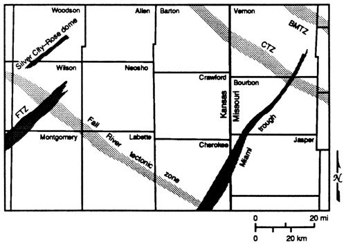
Lamproite intrusions of Cretaceous age at Rose and Silver City domes in Woodson and Wilson counties (fig. 2) occur along another northeast-trending zone of faults and folds. At Rose dome, granite boulders incorporated into the intrusion (Franks and others, 1971) represent the only occurrence of Precambrian rock (Bickford and others, 1981) at the surface in Kansas.
Within the mostly volcanic terrane in the southern tier of counties in the Kansas portion of the quadrangle, eight Precambrian monadnocks that rise abruptly above the basement surface have been identified (plate 1). They can reach heights of 1,000 ft (300 m) or more. With the exception of two, in which the drill penetrated granite, all the other monadnocks consist of volcanic rock (mostly rhyolite). In sec. 12, T. 33 S., R. 16 E., the two wells may in fact penetrate a single monadnock. Numerous and more closely spaced hills protrude from the Precambrian basement in northeastern Oklahoma, where they are referred to as the Tulsa Mountains (Ireland, 1955). There is no discernable structural trend to these erosional remnants, although some are apparently faulted (Reeder, 1976; Ireland, 1955). The monadnocks in southeastern Kansas probably represent the eroded northern fringe of this terrane.
Differential gravitational compaction of the overlying sediments over monadnocks in the Joplin quadrangle and northeastern Oklahoma (Ireland, 1955; Gay, 1989) has resulted in the formation of subtle domal closures that may serve as loci for later mineralizing fluids.
It is difficult to date motions occurring on faults cutting the Precambrian basement. Recurrent movement on structure has been well documented throughout the region (Clendenin and others, 1989; Sims and others, 1987; Berendsen and Blair, 1986; Kisvarsanyi, 1984). Structures mapped in the Mississippian and Arbuckle rocks frequently correspond to geophysical lineaments mapped in the basement. The last major movement on faults occurred during the Late Mississippian--Early Pennsylvanian Ouachita orogeny. It is unknwon what influence streses imparted by younger orogenic events (i.e., Marathon, Laramide) may have had upon the structures in the area.
Our map (plate 1) shows the drill holes that penetrate the Precambrian basement, along with rock type encountered, depth of penetration, and the elevation of the basement with respect to sea level. Areal distribution of drill holes throughout the quadrangle is irregular. In areas where the concentration of drill-hole penetrations is sufficiently great, larger terranes underlain by similar rock types can be identified with a certain amount of confidence. Some of these terranes exhibit characteristic signatures on geophysical maps, which in turn may be used to infer basement geology in arm lacking drill-hole control. The approximate boundaries or contacts of these terranes may be inferred using this information together with magnetic linear structures and mapped faults.
However, the physical properties of various rock types, such as those of certain granites and rhyolites, may not be specific or contrasting enough to enable us to identify the rock types with confidence. Also, many workers have suggested that the basement surface rock may only form a relatively thin veneer overlying deeper basement rock of similar or different composition (Bickford and others, 1986). Granite penetrations in southwestern Montgomery County, where analysis of aeromagnetic and gravity anomalies would suggest a mafic pluton, may be an example of such a change in rock type at depth.
In the northwestern part of the quadrangle, low-grade metasedimentary rocks have been identified in a number of drill holes. Sims (1990) and Kisvarsanyi (1979) note that most of the Precambrian sedimentary rocks in Missouri occur in a graben between the Bolivar-Mansfield and the Chesapeake tectonic zones. On the aeromagnetic map this area has a low magnetic signature and is bounded by strong northwest-trending, and weaker northeast-trending, magnetic linear structures, as well as mapped faults. On the basis of well penetrations and magnetic signatures, our interpretation extends the area of these rocks to the southwest into Barton County, Missouri, and into Bourbon and Crawford counties, Kansas. We believe that these metasedimentary rocks occur in localized Precambrian basins. Some metasedimentary rocks may occur in Labette County, Kansas, south of the Fall River tectonic zone. This occurrence is along the same trend of the basins in Bourbon and Crawford counties. A northwest-trending, 3-4 mi wide, fault-bounded graben in Montgomery County, Kansas, may be interpreted as a wedge of sediments shed from the adjoining granitic highlands.
Rhyolitic rocks have been identified in drill holes mostly in the southern tier of counties. In Kansas most of these rocks are confined to the area south of the Fall River tectonic zone, which we believe to represent a major terrane boundary in the quadrangle. In areas where drill-hole information is lacking, recognition and interpretation of rhyolitic terranes becomes difficult. Because of the similar nature of their magnetic signatures, some rhyolite occurrences may be expected within the dominant granitic terrane, and vice versa. Many of the monadnocks protruding from the basement in the southern portion of the quadrangle are rhyolitic and may represent volcanic necks. These would then indicate possible centers of volcanic activity from which flows spread outward.
Most of the area is interpreted to be underlain by granitic rocks, some of which may contains appreciable amounts of magnetite. These intrusions often give rise to characteristic circular or oval magnetic anomalies.
In a few instances other rock types have been encountered in drill holes. Their areal extent is small and they have not been mapped as separate rock units at this stage. For instance, throughly altered and mylonitized andesite was penetrated in several drill holes at the intersection of the Miami trough and the Fall River tectonic zone in Cherokee County, Kansas. In addition, syenite has been identified in a single well in southern Wilson County, Kansas.
Plate 1 shows the distribution of Precambrian drill-hole penetrations, the major faults that have been mapped in the overlying Paleozoic sedimentary rocks and the basement, and major geophysical linear trends. Not enough drill-hole control is available to define contacts between basement rock types accurately. Faults and geophysical linear trends appear to delineate geologic boundaries in a number of cases.
This map also portrays the regional distribution of major Precambrian rock types in the Joplin quadrangle, using the integrated geological and geophysical information available at the present time.
The study of the geology of the Joplin quadrangle was conducted as part of a cooperative study between the Department of Natural Resources, Missouri Geological Survey, the Central Mineral Resources Branch of the U.S. Geological Survey, Denver, and the Kansas Geological Survey. This publications benefitted greatly from informal discussions with various researchers involved in the program. We would like to thank Jennifer Sims for helping prepare the illustrations and Jorgina Ross for the production of the basement map.
Aydin, A., and Nur, A., 1982, Evolution of pull-apart basins and their scale independence: Tectonics, v. 1, no. 1, p. 91-105
Berendsen, P., and Blair, K. P., 1986, Subsurface structural maps over the Central North American rift system (CNARS). central Kansas, with discussion: Kansas Geological Survey, Subsurface Geology Series 8, 16 p. [available online]
Bickford, M. E., Van Schmus, W. R., and Zietz, I., 1986, Proterozoic history of the midcontinent region of North America: Geology, v. 14, p. 492-496
Bickford, M. E, Harrower, K. L., Hoppe, W. J., Nelson, B. K., Nusbaum, R. L., and Thomas, J. J., 1981, Rb-Sr and U-Pb geochronology and distribution of rock types in the Precambrian basement of Missouri and Kansas: Geological Society of America Bulletin, Part 1, v. 92, p. 323-341
Bickford, M. E. Harrower, K. L., Nusbaum, R. L., Thomas, J. J., and Nelson, G. E., 1979, Preliminary geologic map of the Precambrian basement rocks of Kansas: Kansas Geological Survey, Map M-9, scale 1:500,000 [available online]
Blair, K. P., Berendsen, P., and Seeger, C. M., in press, Subsurface structural geology of the Joplin quadrangle, top of the Mississippian carbonates and the Arbuckle Group: U.S. Geological Survey, Miscellaneous Field Studies
Brockie, D. C., Hare, E. H., and Dingess, P. R., 1968, The geology and ore deposits of the Tri-State district of Missouri, Kansas, and Oklahoma; in, Ore Deposits of the United States, 1933-1967, The Graton-Sales Volume, J. D. Ridge, ed.: The American Institute of Mining, Metallurgical, and Petroleum Engineers, Inc., New York, p. 4OD-430
Clendenin, C. W., Niewendorp, C. A., and Lowell, G. R., 1989, Reinterpretation of faulting in southeast Missouri: Geology, v. 17, p. 217-220
Cole, V. B., and Watney, L. W., 1985, List of Kansas wells drilled into Precambrian rocks: Kansas Geological Survey, Subsurface Geology Series 7, 139 p.
Denison, R. E., 1966, Basement rocks in adjoining parts of Oklahoma, Kansas, Missouri, and Arkansas: Ph.D. dissertation, University of Texas, Austin, 292 p.
Denison, R. E., Lidiak. E. G.. Bickford, M. E., and Kisvarsanyi, E. B., 1984, Geology and geochronology of Precambrian rocks in the central interior region of the United States: U.S. Geological Survey, Professional Paper 1241-C, 20 p.
Franks, P. C., Bickford, M. E., and Wagner, H. C., 1971, Metamorphism of Precambrian granitic xenoliths in a mica peridotite at Rose dome, Woodson County, Kansas--Part 2, Petrologic and mineralogic studies: Geological Society of America Bulletin, v. 82, p. 2,869-2,890
Gay, S. Parker, Jr., 1989, Gravitational compaction, a neglected mechanism in structural and stratigraphic studies--new evidence from midcontinent USA: American Association of Petroleum Geologists, Bulletin, v. 73, no. 5, p. 641-657
Greene, F. C., and Pond, W. F., 1926, The geology of Vernon County: Missouri Bureau of Geology and Mines, v. 19, p. 70-72
Haworth E., and Bennett, J., 1908, Chapter U. General stratigraphy: The University Geological Survey of Kansas, v. IX (Special Report on Oil and Gas), p. 57-159
Huddleston, P. J., and Southwick, D. L., 1984, The role of transcurrent shear in deformation of the Archean rocks of the Vermillion district, Minnesota: Thirtieth Annual Institute on Lake Superior Geology, Wassau, Wisconsin p. 20
Ireland, H. A., 1955, Precambrian surface in northeastern Oklahoma and parts of adjacent states: American Association of Petroleum Geologists, Bulletin, v. 39, no. 4, p. 468-483
Kisvarsanyi, E. B., 1974, Operation Basement--buried Precambrian rocks of Missouri--their petrography and structure: American Association of Petroleum Geologists, Bulletin, v. 58, no. 4, p. 674-684
Kisvarsanyi, E. B., 1975, Data on Precambrian in drill holes of Missouri, including rock type and surface configuration: Missouri Department of Natural Resources Geological Survey, Report of Investigations No. 56 (Contribution to Precambrian Geology no. 5), 24 p.
Kisvarsanyi, E. B., 1979, Geologic map of the Precambrian of Missouri: Missouri Department of Natural Resources, Division of Geology and Land Resources, Contribution to Precambrian Geology no. 7, scale 1:1,000,000
Kisvarsanyi, E. B., 1984, The Precambrian tectonic framework of Missouri as interpreted from the aeromagnetic anomaly map: Missouri Department of Natural Resources, Contribution to Precambrian Geology, Part B, no. 14, 19 p.
Lam, Chi-Kin, 1987, Interpretation of statewide gravity survey of Kansas: Ph.D. dissertation, University of Kansas, Lawrence, 213 p.
Ley, H. A., 1924, Subsurface observations in southeast Kansas: American Association of Petroleum Geologists, Bulletin, v. 8, no. 4, p. 445-453
Lidiak, E. G., 1972, Precambrian rocks in the subsurface of Nebraska: Nebraska Geological Survey, Bulletin 26, 41 p.
McCafferty, A. E., and Cordell, L., in preparation, Geophysically inferred structural and lithologic map of the Precambrian basement in the Joplin 1 x 2 degree quadrangle, Kansas and Missouri: U.S. Geological Survey, Miscellaneous Field Studies
McCracken, M. H., 1971, Structural features of Missouri: Missouri Geological Survey and Water Resources, Report of Investigations 49, 100 p.
Nelson, B. K., and DePaolo, D. J., 1982, Crust formation of the North American continent: Geological Society of America, Abstracts with Programs, v. 14, p. 575
Reeder, L. R., 1976, The control of potential Arbuckle hydrocarbon traps in northeastern Oklahoma by Precambrian topography: Tulsa Geological Society, Shale Shaker Digest, p.176-186
Scott, R. W., 1966. New Precambrian formation in Kansas: American Association of Petroleum Geologists, Bulletin, v. 50, no. 2, p. 380-384
Sims, P. K. (compiler), 1990, Precambrian basement map of the northern midcontinent, U.S.A.: U.S. Geological Survey, Miscellaneous Investigations Series, Map 1-1853-A (with accompanying text)
Sims, P. K., and Peterman, Z. E., 1986, The Early Proterozoic Central Plains orogen--a major buried structure in north-central United States: Geology, v. 14, p. 488-491
Sims, P. K., Kisvarsanyi, E. B., and Morey, G. B., 1987, Geology and metallogeny of Archean and Proterozoic basement terranes in the nortern midcontinent, U.S.A.--an overview: U.S. Geological Survey, Bulletin 1815, 51 p.
Skillman, M. W., 1948, Pre-Upper Cambrian sediments of Vernon County, Missouri: State of Missouri, Geological Survey and Water Resources, Report of Investigations no. 7. 17 p.
Stryker, W. L., 1925, Subsurface geology of Wilson County, Kansas [with discussion]: American Association of Petroleum Geologists, Bulletin, v. 9. no. 8, p. 1,207-1,214
Thomas, J. J., Shuster, R. D., and Bickford, M. E., 1984, A terrane of 1,350- to 1,400-my.-old silicic volcanic and plutonic rocks in the buried Proterozoic of the midcontinent and in the Wet Mountains, Colorado: Geological Society of America Bulletin, v. 95, p. 1,150-1,157
Yarger, H. L., 1983, Regional interpretation of Kansas aeromagnetic data: Kansas Geological Survey, Geophysics Series 1, 35 p. [available online]
Yarger, H. L., 1985, Kansas basement study using spectrally filtered aeromagnetic data; in, Utility of Regional Gravity and Magnetic Anomaly Maps, W. J. Hinze, ed.: Society of Exploration Geophysicists, Special Volume, p. 213-232
Yarger, H. L., 1989, Major magnetic terranes in Kansas and their possible geologic significance; in, Geophysics in Kansas, D. W. Steeples, ed.: Kansas Geological Survey, Bulletin 226, p. 197-207 [available online]
Kansas Geological Survey
Placed on web Sept. 15, 2011; originally published in 1991.
Comments to webadmin@kgs.ku.edu
The URL for this page is http://www.kgs.ku.edu/Publications/Bulletins/Sub14/index.html