Kansas Geological Survey, Subsurface Geology 12, p. 1-4
by
Christopher G. St. C. Kendall1, John Strobel1, Phil Moore2, Robert Cannon2, James Bezdek3, and Gautam Biswas4
1Department of Geological Sciences, University of South Carolina
2Department of Computer Science, University of South Carolina
3Department of Computer Science, University of West Florida
4Department of Computer Science, Vanderbilt University
Use of SEDPAK is illustrated with examples from the Permian basin of west Texas and New Mexico, the Permian of the Sichaun basin, the Upper Devonian of western Canada, and the Cretaceous and Tertiary of the Bahamas. The interactive computer simulation program SEDPAK tracks cross sections of clastic and carbonate sedimentary bodies as a basin fills from both sides. Data entered to run SEDPAK include the initial basin configuration, local tectonic behavior, sea-level curves, the amount and source direction of clastic sediment, and the growth rates of carbonates as a function of water depth. SEDPAK is implemented in C (Kernighan and Ritchie, 1978), uses the X-window system for graphical-plotting functions, and is operated on a UNIX-based work station, such as DEC 3100, SUN, and/or APOLLO.
SEDPAK represents a system that can test seismic interpretations based on sea-level curves. These curves can be input parameters to the program. The program responds to tectonic movement, eustasy, and sedimentation, modeling sedimentary bypass and erosion. It reproduces lacustrian, alluvial, and coastal plains; marine shelf, basin slope, and basin floor; clastic settings and progradation; the development of hardgrounds, downslope aprons, keep-up, catch-up, back-step, and drowned reef facies; and lagoonal and epeiric sea facies in carbonate settings. It simulates extensional vertical faulting of the basin, sediment compaction, and isostatic response to sediment loading. Sediment geometries can be viewed immediately on a graphics terminal as they are computed. Based on the observed geometric patterns, parameters can be repeatedly changed and the program rerun until the user is satisfied with the resultant geometry.
SEDPAK is a stochastic computer model that tracks evolving sedimentary geometry as a basin is filled by clastic sediments, and by the production and transport of in situ carbonates responding to sea-level changes. Clastic depositional phenomena incorporated include clastic infilling of topographic depressions, creation of sediment wedges or fans, draped fill over topography, procedures to ensure that clastic sediments penetrate a minimum distance into the basin, and devices to monitor the volume and areal distribution of the sediments being deposited. The effects of eustatic changes upon clastic-sediment deposition also are modeled. Important carbonate phenomena modeled include the influence of eustasy upon the accumulation rate and the rates of progradation or retreat of carbonates.
Additional influences upon sediment geometries include faulting of the basin, water depth, erosion of previously deposited sediments, submarine slumping, compaction of sediments, and isostatic subsidence of the basin. For a complete description of the SEDPAK algorithm, see Strobel et al. (1987), Helland-Hansen et al. (1988,1989), Nakayama and Kendall (1989), Kendall, Tang, et al. (in press), and Strobel et al. (in press).
The "volume" of clastic sediment deposited from either side of the basin at each time step is simulated by the use of two right-angle triangles, one each for sand and shale. The area of the triangles represents the volume of sand or shale available, respectively, for deposition at that time step, and the base of the triangle represents the maximum distance that the respective sediment penetrates into the basin from that margin at that time step. The triangles are a device to model die distance the sediments are transported into the basin and simplify the simulation of depositional processes.
Deposition occurs as follows: 1) If the slope does not exceed the angle of maximum stability, sediment is deposited on that column up to a height controlled by the maximum stability angle. Then the simulation deposits sediments from the current column away from the center of the basin up to a maximum stability slope. If it is above sea level, this slope defines the surface of the alluvial plain or if it is below sea level, it defines the surface of a submarine slope. Sediment fans terminate upslope at the point at which the present surface of the basin exceeds the stable slope. 2) If the combined sediment heights of the triangles do not reach the maximum deposition height possible, then the simulation deposits the sediments that are available from the area of the sediment triangle.
The main influence upon the amount of carbonate to be deposited in each column is the depth of water for that column mimicking the response of carbonate-producing organisms to photosynthesis. The amount of carbonate accumulation in each column is influenced by 1) wave energy damping rates of carbonate accumulation on build-ups or reef margins; 2) the presence of "reefs" or build-ups on the margins of lagoons that limit aerating waves or nutrient supply into the lagoons and within epeiric seas, so reducing accumulation rates; and 3) the amount of clastic material deposited in the column, which damps carbonate growth and mimics the oversupply of nutrients to the area. Transported carbonate talus is modeled by assuming that talus deposition follows rules similar to those for clastic materials.
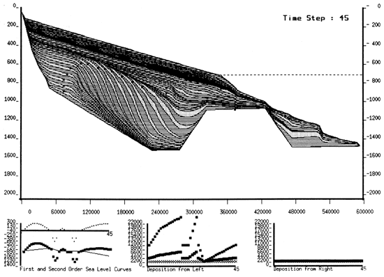
The block (fig. 1) output shows how SEDPAK handles offshore topographic relief and models drape when clastic sediments encounter some offshore topographic relief. The tolerance level for offshore topographic relief is a user-supplied input. Fig. 1 shows how SEDPAK first fills in the offshore topographic relief and then proceeds to deposit sediments past the relief once it has been topped. The salt data set (fig. 2) shows that features such as salt ridges can be incorporated into the simulation. In addition, the user can model varying density uplift for the salt ridges.
Figure 1--Output of the block data set showing how SEDPAK can model offshore topographic relief. Sand is represented by dots and shale is represented with horizontal lines.
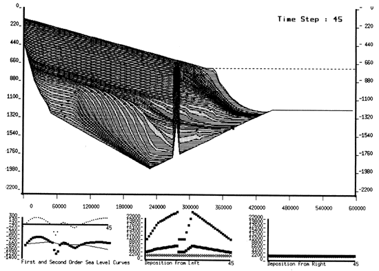
Figure 2--Output of the salt data set showing how SEDPAK can model salt ridge-like features within a basinal environment. Sand is represented by dots and shale is represented with horizontal lines.
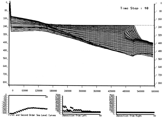
To demonstrate how the SEDPAK algorithm works, we used several geologic examples including the Permian sediments of west Texas and New Mexico (Kendall, Strobel, et al., 1989; Kendall, Harris, et al, 1989; Kendall, Tang, et al., in press; fig. 3), and the sedimentary fill of the Sichuan Basin of China by Upper Permian coals and carbonate sequences (Tang et al., 1989; fig. 4).
The sediments of the west Texas Upper Permian are composed of carbonate and clastics (Kendall, Strobel, et al., 1989; Kendall, Harris, et al, 1989; Kendall, Tang, et al., in press). We used as the geometries that we were trying to duplicate, cross sections of the Upper Permian Capitan margin of the northern Delaware basin made by King (1942) and Harris and Grover (1989). These cross sections show a mixed carbonate/clastic sequence prograding from 4 to 19 kn (2-11 mi) into a basin, at least 400 m (1,320 ft) deep, over a period of 2.5 m.y. Locally, the Seven Rivers Formation carbonate margin aggrades some 140 m (462 ft) with little progradation, then it moves seaward over its debris some 3 to 7 km (2-4 mi), aggrading about 10 m (33 ft). The carbonate margin of the Yates and Tansiff Formations aggrades 140 m (462 ft) with a progradation of about 3 km (2 mi).
Figure 3--Output of the permian data set showing SEDPAK reproducing the geometries of the Upper Permian of the west Texas Permian basin. Sand is represented by dots, shale is represented with horizontal lines, and carbonates are represented with vertical lines.
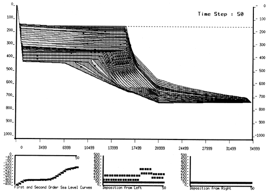
Using SEDPAK, the present geometries of the sediments of the Permian basin Capitan shelf margin were reproduced by having a rapid third-order sea-level rise upon which 3-10-m (10-33-ft) fourth-order sea-level fluctuations were superimposed.
Most of the carbonate sediment was modeled as forming in less than 20 m (66 ft) of water at the basin margin with most of the carbonate that is produced being transported downslope to form the prograding clinoforms of the margin. The margin was allowed to develop a stable carbonate slope of up to 20° (a response to active cementation) and a siliciclastic slope of 1.6°. The siliciclastics were modeled by trapping them updip during sea-level high stands and having them bypass the margin at low stands to collect in the basin. The models developed with SEDPAK suggest that the Permian basin was being rapidly filled by the prograding carbonate margin and clastic bypass.
Data on the Upper Permian Sichuan basin were provided by a visiting scholar from China (Tang et al., 1989). The Upper Permian Sichuan basin is underlain by basaltic lava flows. Over these basaltic lava beds a transgressive, aggrading clastic sequence was deposited. As the clastic sediments onlapped shelfward, deep-water carbonates began deposition in the distal basin where clastic sediment was starved. As the sea-level rise continued, clastic sedimentation in the basin decreased and the deep-water carbonates began shoaling upwards, finally reaching sea level to prograde into the basin. Our simulation was able to capture the geometries and the sense of the Sichuan Upper Permian (fig. 4).
Figure 4--Output of the Sichuan data set showing SEDPAK reproducing the geometries of the Upper Permian of the Sichuan basin. Sand is represented by dots, shale is represented with horizontal lines, and carbonates are represented with vertical lines.
Other examples include the modeling of the accumulation of carbonates in the Upper Devonian in western Canada (Scaturo et al., 1989) and the Upper Cretaceous and Tertiary of the Bahamas as interpreted by Eberli and Ginsburg (1989).
Eberli, G. P., and Ginsburg, R. N., 1989, Cenozoic progradation of northwestern Great Bahama Bank, a record of lateral platform growth and sea-level fluctuations; in, Controls on Carbonate Platform and Basin Development, P. D. Crevello, J. L. Wilson, J. F. Sarg, and J. F. Read: Society of Economic Paleontologists and Mineralogists, Special Publication 44, p. 339-351
Harris, P. M., and Grover, G. A. (eds.), 1989, Subsurface and outcrop examination of the Capitan shelf margin, northern Delaware basin: Society of Economic Paleontologists and Mineralogists, Core Workshop 13, p. 3-272
Helland-Hansen, W., Kendall, C., Lerche, I., and Nakayama, K., 1988, A simulation of continental basin margin sedimentation in response to crustal movements, eustatic sea-level change, and sediment-accumulation rates: Journal of Mathematical Geology, v. 20, p. 777-802
Helland-Hansen, W., Steel, R., Nakayama, K., and Kendall, C. G. St. C., 1989, Review and computer modeling of the Brent Group stratigraphy; in, Deltas--Sites and Traps for Fossil Fuels, M. K. G. Whately and K. T. Pickering (eds.): Geological Society of America, Special Publication 41, p. 237-252
Kendall, C. G. St. C., Strobel, J., Tang, J., Moore, P., Cannon, R., Bezdek, J., and Biswas, G., 1989, Simulation of the west Texas, New Mexican Permian Guadalupian basin margin-a response to eustatic change, an example of SEDPAK; in, Subsurface and Outcrop Examination of the Capitan Shelf Margin, Northern Delaware Basin, P. M. Harris and G. A. Grover (eds.): Society of Economic Paleontologists and Mineralogists, Core Workshop 13, p. 423-426
Kendall, C. G. St. C., Strobel, J., Harris, P. M., Moore, P., Cannon, R., Bezdek, J., and Biswas, G., 1989, Simulation of the west Texas, New Mexican Permian Guadalupian basin margin--a response to eustatic change, an example of SEDPAK (abs.): 28th International Geological Congress, Washington, D.C., Abstracts, v. 2, p. 2-174
Kendall, C. G. St. C.,Tang, J., Strobel, J., Cannon, R., Moore, P., Bezdek, J., and Biswas, G., in press, Measurement of eustatic changes and the examination of their consequences: American Geophysical Union, Proceedings of the Conference on Longterm Sea-level Changes
Kernighan B. W., and Ritchie, D. M., 1978, The C programming language: Prentice--Hall, Inc.
King, P. B., 1942, Permian of west Texas and southeastern New Mexico: American Association of Petroleum Geologists, Bulletin, v. 26, p. 535-763
Nakayama, K., and Kendall, C. G. St. C., 1989, A simulation of basin margin sedimentation to infer geometry and lithofacies--a carbonate example; in, Sedimentary Facies in the Active Plate Margin, A. Taira and F. Masuda (eds.): Terra Scientific Publishing Company (TERRAPUB), Tokyo, p. 17-31
Scaturo, D. M., Strobel, J. S., Kendall. C. G. St. C., Wendte, J. C., Biswas, G., Bezdek, J., and Cannon, R., 1989, Judy Creek--a case study of a two-dimensional sediment-deposition simulation; in, Controls on Carbonate Platform and Basin Development, P. D. Crevello, J. L. Wilson, J. F. Sarg, and J. F. Read: Society of Economic Paleontologists and Mineralogists, Special Publication 44, p. 4-76
Strobel, J., Kendall, C. G. St. C., Biswas, G., Bezdek, J., and Carmon, R., 1987, Preliminary description of the program SEDFIL with carbonate module added; in, Computer-Aided Methods and Modeling in Geology and Engineering, D. C. Peters and S. A. Krajewsld (eds.): Proceedings of Denver GeoTech, p. 341-349
Strobel, J., Carmon, R., Kendall, C. G. St. C., Biswas, G., and Bezdek, J., in press, Interactive (SEDPAK) simulation of clastic and carbonate sediments in shelf to basin settings: Computers and Geoscience
Tang, J., Kendall, C. G. St. C., Strobel, J., Cannon, R., Moore, P., Bezdek, J., and Biswas, G., 1989, Simulation of the sedimentary fill of the Sichuan basin by Upper Permian coals and carbonate sequences--an example of the use of SEDPAK: American Association of Petroleum Geologists, Bulletin, v. 73, no. 3, p. 418
Kansas Geological Survey
Comments to webadmin@kgs.ku.edu
Web version May 4, 2010. Original publication date 1989.
URL=http://www.kgs.ku.edu/Publications/Bulletins/Sub12/Kendall/index.html