Kansas Geological Survey, Subsurface Geology 12, p. 65-66
by
Philip H. Heckel
University of Iowa
At least 20 Middle/Upper Pennsylvanian major marine cyclothems, each consisting of a thin transgressive limestone, thin offshore dark phosphatic shale, and thick regressive limestone member, extend along outcrop for 600 km (360 mi) from the northern shelf region of Iowa, Nebraska, Missouri, and Kansas, to the basinal region of central Oklahoma. Each is correlated lithostratigraphically throughout a gridwork of long cores in the northern region beneath Pleistocene cover, and in good exposures southward. This correlation is confirmed along the entire outcrop belt biostratigraphically, using a combination of conodonts (fig. 1, tailed diamond symbol), fusulinids (fig. 1, letters T, E), and ammonoids.
Figure 1--Northern shelfward correlation of cyclothems in long cores.
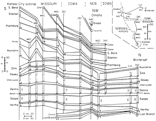
Most of the cyclothems are separated by thin terrestrial deposits with paleosols, but only rare deltaic deposits, for about the northern half of the outcrop distance (fig. 1), which rules out shifting of delta lobes as a general control for the vertical alternation of terrestrial and marine deposits across the broad shell On the northern shelf, all major cyclothems are traced across the cratonic Forest City basin and over the adjacent Nemaha uplift (core NAC on fig. 1) with little change, which rules out local differential tectonics as a general cause. Presence of Gondwanan glacial deposits at this time, in conjunction with the estimated frequencies of all the Pennsylvanian cycles (major to minor) within the Milankovitch band (20 ka to 400 ka) of earth's orbital parameters (Heckel, 1986), indicate that glacial eustasy is a probable cause. No known tectonic mechanism can raise sea level fast enough (>3 mm/yr; Heckel, 1984) and high enough (>150 m [495 ft]; Heckel, 1977) to outstrip carbonate production and form thin transgressive limestones overlain by subthermocline black shales over such an immense area, then lower sea level a similar mount, and do this repeatedly at a 200-400 ka period. This leaves glacial eustasy as the only reasonable possibility so far known for the main control over the cyclothems.
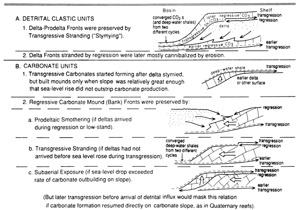
The major cyclothems are well developed and easily recognized on the northern part of the midcontinent shelf where the marine limestone-shale units are separated from one another by the terrestrial deposits and paleosols (shown by hachures on top of the named limestone-dominated units on fig. 1), indicating complete withdrawal of the sea southward between times of marine inundation. The stratigraphy of all the cyclothems becomes more complex southward, where most intervening terrestrial deposits thicken greatly into deltaic to prodeltaic shales that then thin abruptly basinward. The overlying limestones drape over the thick shales, sometimes thickening basinward as phylloid algal mound complexes. Farther southward, they converge with the top of the underlying limestones over the distal end of the prodeltaic shales (fig. 2A), which has led to major miscorrelations at certain horizons. Correction of the miscorrelations by means of conodont faunas shows that much of the Missourian sequence in east-central to southeastern Kansas displays a southward-dipping slope that prograded basinward in an en echelon fashion of the thickest units, as Van Siclen (1958) described in coeval deposits along the east side of the Midland basin in Texas.
The exact position of the thickening of the various units depended on the relationship of the extent of marine withdrawal to the underlying depositional topography. Prodeltaic shales are thickest just basinward of the maximum extent of withdrawal, particularly over topographic lows that were seaward of an underlying slope. Deltaic to alluvial shales became thickest over topographic lows at times when the sea withdrew further toward the basin center. Regressive limestones became thickest where algal sediment built basinward in the optimal part of the photic zone as sea level dropped. Prodeltaic shale slopes were preserved when sea level rose and stymied delta formation by marine transgression (fig. 2A). Phylloid algal limestone slopes were preserved when sea-level rise elevated the optimal photic zone above the sediment surface (fig. 2B-2b), or when sea-level drop exceeded the rate of outbuilding and subaerially exposed the carbonate slope (fig. 2B-2c), or when an encroaching prodelta overwhelmed carbonate production (fig. 2B-2a). Whether or not prodeltas overwhelmed the algal limestone depended both on an available detrital source nearby, and on enough time during falling or stable sea level for this sediment to prograde into the area in question.
Figure 2--Models for basinward stratigraphic relations of eustatic cyclothem units to strandline position at maximum regression and presence of detrital influx.
Although computer modeling should test all possible reasonable combinations of potentially controlling parameters, the actual outcrop and subsurface patterns, and the most probable causes inferred therefrom, provide important constraints as to which of the modeling parameters were most likely to have been significant in developing the stratigraphic sequence.
Heckel, P. H., 1977, Origin of phosphatic black shale facies in Pennsylvanian cyclothems of midcontinent North America: American Association of Petroleum Geologists, Bulletin, v. 6 1, p. 1,045-1,068
Heckel, P. H., 1984, Factors in midcontinent Pennsylvanian limestone deposition; in, Limestones of the Midcontinent, N. J. Hyne (ed.): Tulsa Geological Society, Special Publication 2, p. 25-50
Heckel, P. H., 1986, Sea-level curve for Pennsylvanian eustatic marine transgressive-regressive depositional cycles along midcontinent outcrop belt, North America: Geology, v. 14, p. 330-334
Van Siclen, D. C., 1958, Depositional topography--examples and theory: American Association of Petroleum Geologists, Bulletin, v. 42, p. 1,897-1,913
Kansas Geological Survey
Comments to webadmin@kgs.ku.edu
Web version May 12, 2010. Original publication date 1989.
URL=http://www.kgs.ku.edu/Publications/Bulletins/Sub12/Heckel/index.html