Kansas Geological Survey, Subsurface Geology 12, p. 27-30
by
R. K. Goldhammer1, E. J. Oswald2, and P. A. Dunn1
1Exxon Production Research
2SUNY--Stony Brook
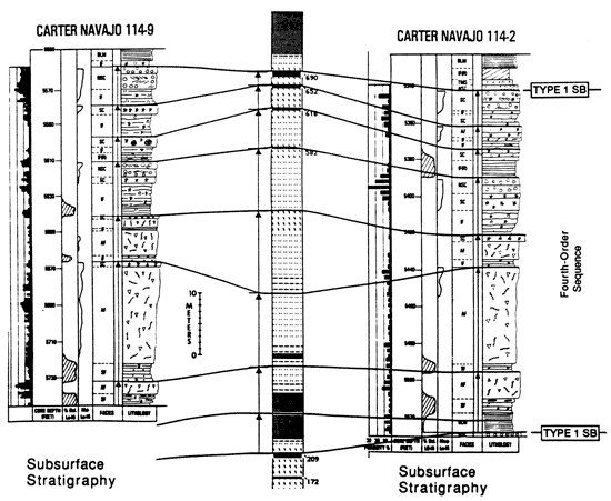
Middle Pennsylvanian (Desmoinesian) shelf carbonates in the southwest Paradox basin display three superimposed orders of stratigraphic cyclicity, in which long-term forcing of higher frequency eustatic cycles by lower frequency eustatic rhythms (at two overlapping scales) has resulted in a systematic succession of cycle-stacking patterns and facies-stacking patterns, as well as predictable vertical diagenetic trends. Fifth-order cycles (34 cycles in 645-ft section at the Honaker Trail; avg. 20 ft (6 m) thick, c. 40 ky duration) are grouped into fourth-order sequences (avg. 100 ft [30 m] thick, c. 400 ky duration), which vertically stack to define a third-order accommodation cycle (650+ ft [195 ml thick, c. 2.4 m.y. duration). A shelfal section at the Honaker Trail spans six fourth-order sequences and correlates in the subsurface 100-120 km (60-72 mi) across the southwest Paradox shelf east and southeast into basinal settings. The outcrop facies and cyclic stratigraphy of one of the fourth-order sequences (the Desert Creek interval of the Paradox Formation) have been tied to the equivalent subsurface productive interval at McElmo Creek (Aneth field) through a detailed core study. This example yields a two-dimensional shelf-to-basin transect where both cycle-stacking patterns and lateral continuity of cycles can be studied.
Fifth-order cycles are composed of shallowing-upward packages of dominantly subtidal shelf carbonates with sharp cycle boundaries, either a subaerial exposure surface (exposure cycles) or a flooding surface (subtidal cycles). From base to top an idealized, complete shoaling cycle consists of the following elements: 1) Basal exposure or flooding surface; 2) Transgressive marine sandstone--TMS: trough crossbedded, calcareous sandstone and laminated, mudcracked siltstone; shallow marine to tidal flat, probable reworked eolian siliciclastics; 3) Black laminated mudstone--BLM: nonfossiliferous, black, shaly mudstones; low-energy, anerobic conditions, >35-m (116-ft) water depth; 4) Sponge facies-SF: silty, argillaceous, cherty carbonate mudstone with abundant sponge spicules and rare phosphatic debris; low-energy, dysaerobic conditions (25-35-m [83-116 ft] water depth); 5) Intermediate facies--IF: thin-bedded, silty, mixed skeletal wackestone-packstone full of normal marine fossils (crinoids, brachiopods, bryozoa, etc.) and burrows; moderate-energy, normal marine subtidal, 5-25-m (17-83-ft) water depth; 6) Algal facies--AF: phylloid-algal mound and mound-flank wackestone-packstone; normal-marine, subtidal phylloid-algal bioherms, 5-25-m [17-83-ft] water depth); 7) Skeletal-cap facies--SC: well-sorted, abraded, mixed skeletal packstone-grainstone; shoaling subtidal, 0-5-m (0-17 ft) water depth; 8) Nonskeletal cap facies--NSC: trough crossbedded and ripple cross-laminated oolitic-peloidal grainstone; high-energy shoaling subtidal; 0-5-m (0-17 ft) water depth; 9) exposure or flooding surface.
Fifth-order cycles are packaged into fourth-order depositional sequences bounded by type 1 (subaerial) sequence boundaries. Criteria for the recognition of sequence boundaries are as follows: a) boundaries are regionally correlative subaerial-exposure surfaces marked by laminar caliches or evidenced by early-developed, meteoric diagenesis in upper parts of fifth-order cycles (solution porosity and meteoric recrystallization in skeletal/nonskeletal cap and phylloid-algal facies); boundaries correlate from outcrop to subsurface (shelf to basin) for 100-120 km (60-72 mi); b) sequence boundaries in shelf-margin to basinal settings are onlapped by basinally restricted evaporite (anhydrite) wedges interpreted as low-stand deposits associated with fourth-order sea-level drops below the Paradox shelf-, c) sequence boundaries in a shelfal position are overlain by BLM facies interpreted as the fourth-order condensed section superimposed atop thin, shelfal low-stand transgressive deposits; d) fifth-order cycle-stacking patterns-subtidal cycles characterize the lower portion and exposure cycles occur in the upper part of fourth-order sequences and, additionally, cycles tend to thin upward within individual fourth-order sequences, reflecting fourth-order accommodation changes. Significantly, the occurrence of siliciclastics (TMS facies) in the section is equivocal with respect to identification of fourth-order sequence boundaries in a shelfal position.
Fourth-order sequences can be subdivided into systems tracts, recognizable on the basis of fifth-order cycle-stacking patterns, vertical and lateral facies associations, and the regional shelf to basin correlation of the top of the BLM facies, interpreted as the fourth-order maximum-flooding surface. Subsurface data demonstrate that the sequences contain a basinally restricted low-stand wedge of evaporites and quartz clastics (20-60 ft [6-18 m] thick) in a downdip position. In detail, onlapping low-stand wedges actually contain higher frequency, mixed clastic-carbonate, fifth-order shoaling cycles that either pinch out below the previous shelf edge or thin updip by onlap. These low-stand, fifth-order cycles are expressed as lengthy subaerial-exposure surfaces high on the shelf. In some of the sequences, on the shelf a thin (<1-3-ft [.3-3 m]) drape of siliciclastics (TMS facies) sits atop the exposure boundary depicting a thin shelfal low stand reflecting siliciclastic bypass. The transgressive systems tract is represented primarily by black, sapropelic shales and shaly carbonate mudstones (BLM facies) which mark the condensed section of the fourth-order sequences. These shaly intervals thicken into the basin (up to 30-40 ft [9-12 m] thick) and thin updip onto the shelf (<3-10 ft [.9-3 m]), essentially superimposed upon the underlying sequence boundary. The high-stand systems tract is characterized by an aggradational stack of shelfal fifth-order cycles and a thinner basinal section composed of deeper water foreslope and basinal facies. The high-stand systems tract comprises the bulk of the sequence in terms of thickness.
Systematic variation in the thickness of the fourth-order sequences (progressive thinning-upward followed by progressive thickening-upward), as well as the number of fifth-order cycles/sequences (decreasing followed by increasing number), as revealed by graphical time-space analysis ("Fischer Plots"), define a third-order accommodation trend which is also regionally correlative. Fifth-order cycles and fourth-order sequences are interpreted as aggradational allocycles generated in response to glacioeustatic sea-level fluctuations driven by Milankovitch climatic forcing. The fifth-order cycles record the earth's obliquity cycle (mean period of 41 k.y.), and the fourth-order sequences result from the long eccentricity cycle (mean period of 413 k.y.). The hierarchy of these two superimposed orders of eustasy is reflected in the approximate 10:1 ratio of fifth-order to fourth-order cyclicity observed in complete sequences. Additionally, in complete sequences, quartz clastics are observed every third fifth-order cycle, suggesting still another level of cyclicity, approximately 120 k.y. in duration, intriguingly close to the earth's short eccentricity cycle. The style of cyclicity (internal-facies architecture and early diagenetic patterns), the hierarchy, and the periodicity of cyclicity observed in the Paradox shelf cycles all are directly analogous to coeval midcontinent shelf cycles (Kansas-Iowa), strongly supporting the existence of Milankovitch-induced glacioeustasy in the Middle Pennsylvanian. Significantly, the short eccentricity cycle (approximately 100 k.y.) and the earth's precessional cycle (approximately 20 k.y.) apparently had minimal amplitudes and minor effect on stratigraphic cyclicity.
The observed stratigraphy has been replicated by computer (Mr. Sediment, figs. 1 and 2), using the following parameters: 1) Eustasy--40 k.y. (sinusoidal, 9-m [30-ft] amplitude), 120 k.y. (sinusoidal, 2-m [7-ft] amplitude), 400 k.y. (asymmetric, 28-m [92-ft] amplitude), 2.4 m.y. (sinuform, 15-m [50-ft] amplitude); 2) Sedimentation--depth-dependent with maximum efficiency at 0-5 m (0- 17 ft; 0.40 m [ 1.3 ft]/1,000 yr.); depth-dependent facies with water depths as defined above; 3) Subsidence--linear and total (0.15 m [0.5 ft]/1,000 yr.); 4) Lag depth--1 m (3.3 ft); 5) Caliche rate--0.01 m (0.03 ft)/1,000 yr. Eustatic amplitudes, as well as depth estimates for facies, are constrained by two-dimensional facies and stratal geometries (corrected for compaction) displayed on shelf-to-basin well-log cross sections.
Figure 1--Simulation stratigraphy using MR. SEDIMENT.
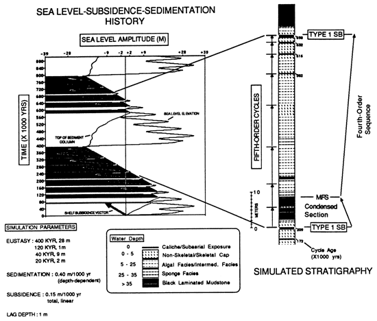
Figure 2--Simulated stratigraphy using MR. SEDMIENT.
Kansas Geological Survey
Comments to webadmin@kgs.ku.edu
Web version May 7, 2010. Original publication date 1989.
URL=http://www.kgs.ku.edu/Publications/Bulletins/Sub12/Goldhammer/index.html