Kansas Geological Survey, Subsurface Geology Series 11, originally published in 1986
Originally published in 1986 as Kansas Geological Survey Subsurface Geology Series 11. This is, in general, the original text as published. The information has not been updated. An Acrobat PDF file containing the complete report is available (1.4 MB).
We made organic carbon determinations, Rock-Eval pyrolysis analysis, and vitrinite reflectance measurements on 72 samples of organic-matter-rich (>1.0% total organic carbon) Middle Pennsylvanian (Desmoinesian) Cherokee Group and Marmaton Group shales and coals and on 13 samples of Upper Devonian-Kinderhookian Chattanooga Shale from southwestern Missouri, southeastern Kansas, and northeastern Oklahoma. These analyses show that the Cherokee Group and Marmaton Group offshore shales and coals and the Chattanooga Shale are thermally mature with respect to petroleum generation and still have good potential to generate oil and/or natural gas. In contrast, the organic matter in the Cherokee Group and Marmaton Group nearshore shales is hydrogen deficient and has little or no generating potential. Comparisons of saturated hydrocarbon, terpane and sterane distributions, pristane/phytane ratios, and carbon isotope compositions of saturated and aromatic hydrocarbon fractions from oils and rock extracts show that oils occurring in sandstone reservoirs of the Cherokee Group are similar to extracts from the Chattanooga Shale and are dissimilar to extracts of Cherokee Group and Marmaton Group offshore shales and coals. We conclude from these correlations that the Chattanooga Shale contains the source rocks for the Cherokee Group oils. These results imply that any porosity trends in Mississippian rocks above the Chattanooga Shale and/or in Paleozoic rocks immediately below it have the potential to be charged with the same oil found in Cherokee Group reservoirs. The excellent hydrocarbon-generating potential shown for the Middle Pennsylvanian offshore shales and coals suggests that these rocks, where thermally mature, may be sources for other midcontinent oils and/or natural gas.
Rocks of the Middle Pennsylvanian (Desmoinesian) Cherokee Group in the midcontinent area of the United States are a complex mixture of coal cyclothem rock types that record deposition in marine, transitional marine, and nonmarine environments. In northeastern Oklahoma and southeastern Kansas oil is extracted from these rocks, primarily from traps along the basal Pennsylvanian unconformity and from stratigraphic traps in lenticular sandstone reservoirs [i.e., Burgess, Burbank, Bartlesville, Skinner, and Prue sands (drillers' terms)]. The apparent isolated character of many of these sandstone reservoirs has led previous researchers (McCoy and Keyte, 1934; Clark, 1934; Bass, 1936; Weirich, 1953; Baker, 1962; Baker and Ferguson, 1964; Hedberg, 1964; Baker et al., 1969) to suggest that the surrounding nonreservoir rocks are source rocks for the petroleum.
Modern studies that correlate Cherokee Group oils with specific source rocks within the Middle Pennsylvanian section are lacking. More important, there has been little consideration of other lithologic units within the middle and upper Paleozoic section as possible source rocks of the Cherokee Group oils. In this paper we (1) characterize the organic geochemistry of the oils in Cherokee Group reservoirs; (2) characterize the thermal maturity of the organic matter, the hydrocarbon-generating potential, and the extract geochemistry of the organic-matter-rich rocks within the Middle Pennsylvanian section (Cherokee Group and overlying lower part of the Marmaton Group) and in the Late Devonian-Kinderhookian Chattanooga Shale; and (3) correlate the Cherokee Group oils with specific source rocks.
Baker (1962) was the first to study the organic geochemistry of Cherokee Group rocks and oils. He reported organic carbon contents, amount of extractable hydrocarbons, and saturated hydrocarbon/aromatic hydrocarbon ratios for various rocks within the Cherokee Group. He found that different rocks have distinct hydrocarbon compositions and that the saturated hydrocarbon/aromatic hydrocarbon ratios from the marine shales and limestones are similar to those of Cherokee Group oils. Baker (1962) indicated that all the nonreservoir rock types probably contribute to the Cherokee Group oil accumulations. Hunt (1979, p. 504), in discussing Baker's (1962) data, questioned whether the organic-lean rocks (such as underclays and greenish-gray shales) are significant contributors of petroleum. He pointed out that the most likely hydrocarbon source rock in the Cherokee Group is the marine black shale lithofacies (offshore shale). This lithofacies is volumetrically only a minor part of the section, however, and the lowest stratigraphic occurrence of it is above many of the principal producing sands.
Other studies of the organic geochemistry of Cherokee Group rocks and oils in the midcontinent area were conducted by Baker and Ferguson (1964), James (1970), James and Baker (1972), Hatch et al. (1984), Hatch and Leventhal (1981, 1982, 1985), Wenger and Baker (1986), and Coveney et al. (1987). Baker and Ferguson (1964) compared δ13C of hydrocarbons (saturated + aromatic hydrocarbon) separated from 24 Cherokee Group oils with δ13C of hydrocarbons extracted from a composite section of Cherokee Group rocks in Greenwood County, Kansas. Mean δ13C for the 24 oils was -28.0‰; for the extract of the composite section, δ13C was -26.3‰.
James (1970) conducted a regional study of a single black shale (Excello shale) in the upper part of the Cherokee Group. Citing the work of James (1970), James and Baker (1972) proposed that one of the major controls on regional variability in saturated hydrocarbon/aromatic hydrocarbon ratios from extracts of the Excello shale is differences in the relative proportion of marine and terrestrial organic matter.
Hatch et al. (1984) collected 247 samples of Cherokee Group and Marmaton Group rocks from cores and coal mines at 21 locations in southeastern Iowa, Missouri, southeastern Kansas, and northeastern Oklahoma. They list organic carbon contents and Rock-Eval pyrolysis results for the 247 samples, vitrinite reflectance values for 19 coal samples, extractable organic matter compositions for 77 samples, and carbon isotope compositions of saturated and aromatic hydrocarbon fractions for extracts from 18 rock samples and 6 Cherokee Group oils.
Hatch and Leventhal (1981, 1982, 1985) identified four different organic geochemical facies in the Cherokee Group and the overlying lower part of the Marmaton Group. The four facies, characterized by organic carbon content, hydrogen index (Rock-Eval pyrolysis), organic carbon isotope composition, extract geochemistry, and trace element content, reflect differences in organic matter source, relative amount of dissolved oxygen in the depositional environment, and degree of early postdepositional aerobic alteration of the organic matter.
Wenger and Baker (1986), using a variety of techniques, characterized the organic geochemistry and organic petrography of the Little Osage shale (Marmaton Group) and Excello shale (Cherokee Group) (plus transitional rock types) in two cores from southeastern Kansas and northeastern Oklahoma. They showed large and systematic variations in geochemical properties within the black shale units and related these variations to variable supplies of nutrients and humic detritus resulting from eustatic rise of sea level and rapid marine transgression over the continental craton.
Coveney et al. (1987) related metal contents in the marine black shales in the upper part of the Cherokee Group in Missouri and Kansas and in stratigraphically equivalent shales in Illinois and Indiana to type of organic matter (defined by Rock-Eval pyrolysis and pyrolysis gas chromatography) and proximity to the paleoshoreline.
Organic geochemical data for three groups of samples are summarized in this study:
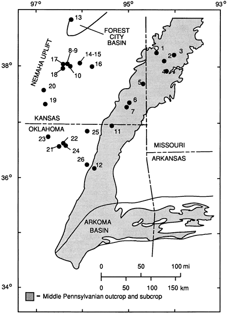
We list the locations and depth intervals of the sampled cores, strip mines, and oils in appendix 1 and show the locations in figure 1. We list the sample numbers, descriptions, and depth intervals for the 72 Cherokee Group and Marmaton Group samples and the 13 Chattanooga Shale samples in appendix 2. We selected rock samples on the basis of color (N1, N2, and N3 hues, GSA rock color chart).
Figure 1--Locatlons of sampled Cherokee Group oil fields and sampled Cherokee Group, Marmaton Group, and Chattanooga Shale rocks in Southwestern Missouri, southeastern Kansas, and northeastern Oklahoma. Locations are listed in appendix 1. Outcrop line is from King et al. (1974).
The 72 Cherokee Group and Marmaton Group samples represent three lithofacies: offshore shale, coal, and some shale beds within the nearshore shale [nomenclature from Heckel (1977) and Ebanks et al. (1979)]. We determined lithofacies for the sampled intervals from lithology and stratigraphic position.
Organic-matter-rich rocks (N1, N2, and N3 hues, GSA rock color chart) make up a relatively small part of the Cherokee Group and Marmaton Group. For example, at locality 11 in northeastern Oklahoma, the Cherokee Group is 501 ft (153 m) thick. At this locality 77.5 ft (23.6 m) of nearshore shale, 13.1 ft (4.0 m) of coal, and 11.7 ft (3.6 m) of offshore shale (totaling about 20% of the section) qualify as organic matter rich. At this same locality the lower 185 ft (56.4 m) of the Marmaton Group contains no organic-matter-rich nearshore shale, 1.0 ft (0.30 m) of coal, and 11.7 ft (3.6 m) of offshore shale (totaling about 7.0% of the section).
Core samples of the Chattanooga Shale in southeastern Kansas and northeastern Oklahoma are scarce and, where they are available, represent only a fraction of the thickness of the formation. As examples, the samples of Chattanooga Shale (appendixes 1 and 2) collected for this study represent the basal 3 ft (0.9 m) (Davis A #2 well), the basal 12 ft (3.7 m) (Bock #1 well), and the basal 9 ft (2.7 m) (Stauffer #1 well) of the shale. In this part of eastern Kansas the Chattanooga Shale is between 50 ft and 100 ft (15 m and 30 m) thick (Adler et al., 1971, fig. 13).
We determined total organic carbon (TOC) contents by a wet oxidation method slightly modified from Bush (1970). Procedures for measuring vitrinite reflectance (%R0, oil immersion, random orientation) are described by Bostick and Alpern (1977).
For the Rock-Eval pyrolysis assays we used the instrument (Girdel, Inc.) and method of Espitalié et al. (1977). This method measures contents of volatile hydrocarbons (S1 peak, mg HC/g rock), pyrolytic hydrocarbons (S2 peak, mg HC/g rock), pyrolytic carbon dioxide (S3 peak, mg CO2/g rock), and temperature of maximum rate of pyrolytic hydrocarbon generation (Tmax). S1, S2, and S3 are combined or normalized by TOC to generate various indexes used for source rock evaluation, including genetic potential (S1 + S2, mg HC/g rock), hydrogen index (S2/TOC, mg HC/g TOC), and oxygen index (S3/TOC, mg CO2/g TOC). Hydrogen index and oxygen index correlate with kerogen H/C and O/C ratios, respectively (Espitalié et al., 1977; Off, 1983).
We extracted bitumens from powdered rock samples using a Soxhlet apparatus and chloroform for 24 hours. To remove sulfur, we refluxed with polished copper metal. We then concentrated the filtered extract solution at room temperature in a nitrogen atmosphere and diluted the solution with n-heptane to precipitate asphaltenes. We next separated a concentrate of the solution by using column chromatography on silica gel, eluting successively with heptane, benzene, and benzene-methanol (1:1 v/v) to collect the saturated hydrocarbon, aromatic hydrocarbon, and resin (NSO) fractions, respectively. We treated oil fractions in the same manner.
We used a Hewlett-Packard 5880 instrument for gas chromatography analyses of the saturated hydrocarbon fractions of oils and rock extracts. This instrument was equipped with a wall-coated open-tubular (WCOT) column, 50 m x 0.35 mm I.D., coated with SE54, and was temperature programmed from 50°C to 320°C at 4°C/min. The flame ionization detector temperature was 350°C; the injection port temperature was 245°C, with 1 µL injected. We based the identification of peaks on the resultant chromatograms on relative retention time.
For gas-chromatography mass spectrometry analysis we used a Hewlett-Packard 5880 instrument directly coupled to a Kratos MS-30 mass spectrometer. The BP 5880 was equipped with a WCOT 50 m x 0.35 mm I.D. column coated with SE54 and temperature programmed from 80°C to 160°C at 10°C/min and then from 160°C to 340°C at 3°C/min. We operated the mass spectrometer ion source at 70 eV with a pressure of 10-6 torr at a temperature of 200°C. To determine relative distributions of terpanes (m/z = 191) and steranes (m/z = 217), we used multiple ion detection. This was accomplished by switching the accelerating potential to the specific mass at a constant magnetic field and scanning over the mass peak ±250 mg/kg for 100 ms for each mass monitored.
We converted saturated and aromatic hydrocarbon fractions separated from oils and rock extracts to carbon dioxide in a high-vacuum combustion gas-transfer apparatus. We determined stable-carbon isotope ratios with a Finnigan MAT 251 isotope-ratio mass spectrometer. We directly compared the isotope compositions of carbon dioxide from the samples to working reference standards of carbon dioxide prepared from NBS limestone (δ13C = 1.96 ‰ PDB). All ratios are reported as standard per-mil deviation relative to the Peedee belemnite standard (PDB):
δ13C ‰ = [(R sample/R standard) - 1] X 10-3,
where R is the ratio of 13C to 12C.
Genetic potential (S1+ S2, mg HC/g sample) is a summary measure of hydrocarbon-generating potential and depends on organic matter amount, type, and thermal maturity (Espitalié et al., 1977; Tissot and Welte, 1978, p. 445-447). In this study we measured the amount of organic matter by total organic carbon content (wt %). We determined the type of organic matter by hydrogen index (mg HC/g TOC) and oxygen index (mg CO2/g TOC) and the organic matter thermal maturity by Tmax(°C) and vitrinite reflectance (%R0).
The minimum organic carbon content necessary to generate and expel oil from a shale source rock lies between 0.4% and 1.4%, with the minimum probably closer to the higher of these two values (Ronov, 1958). Organic carbon contents for 72 samples from the Cherokee Group and Marmaton Group and 13 samples from the Chattanooga Shale are listed in appendix 3 and summarized in table 1. The data in table 1 show that the organic carbon contents of the three lithofacies within the Cherokee Group and Marmaton Group [nearshore shales (![]() = 2.9%, n = 19), offshore shales (
= 2.9%, n = 19), offshore shales (![]() = 13%, n = 24), and coals (
= 13%, n = 24), and coals (![]() = 60%, n = 29)] and the Chattanooga Shale (
= 60%, n = 29)] and the Chattanooga Shale (![]() = 3.5%, n = 13) are all significantly higher than 1.4%, suggesting that each could be a source rock for oil and/or natural gas.
= 3.5%, n = 13) are all significantly higher than 1.4%, suggesting that each could be a source rock for oil and/or natural gas.
Table 1--Organic geochemical analyses of Cherokee Group and Marmaton Group shale, coal, and oil samples and Chattanooga Shale samples.
| Cherokee Group and Marmaton Group | Chattanooga Shale |
Cherokee Group Oil |
|||
|---|---|---|---|---|---|
| Nearshore Shale |
Coal | Offshore Shale |
|||
| Organic carbon (%) | 2.9 x 2.0c (n = 19) |
60 ± 13 (n = 29) |
13 x 1.4c (n = 24) |
3.5 ± 0.7 (n = 13) |
|
| Genetic potential (mg HC/g sample)a |
1.6 x 3.0c (n = 19) |
140 ± 47 (n = 29) |
34 x 1.6c (n = 24) |
14 ± 3.7 (n = 13) |
|
| Hydrogen indexb (mg HC/g TOC) |
40 x 2.1c (n = 19) |
230 ± 52 (n = 29) |
240 x 1.2c (n = 24) |
340 ± 50 (n = 13) |
|
| Pristane/phytane ratiod | 3.9 ± 1.0 (n = 8) |
6.0 ± 1.9 (n = 9) |
1.7 ± 0.2 (n = 15) |
1.6 ± 0.1 (n = 2) |
1.6 ±0.1 (n = 11) |
| Saturated HC δ13C (‰)e | -26.6 ± 0.2 (n = 2) |
-27.3 ± 1.1 (n = 3) |
-28.4 ± 0.7 (n = 4) |
-29.2 ± 0.2 (n = 2) |
30.0±0.5 (n = 7) |
| Aromatic HC δ13C (‰)e | -26.1 ± 0.1 (n = 2) |
-25.7 ± 0.8 (n = 3) |
-27.9 ± 0.6 (n = 4) |
-28.5 ± 0.2 (n = 2) |
-28.9 ± 0.4 (n = 7) |
| n = number of samples; blank indicates no data. a. S1 +S2 (Rock-Eval pyrolysis). b. S2/organic carbon. c. Geometric mean and deviation. d. Pristane/phytane ratio is based on relative peak heights. e. Relative to the PDB marine-carbonate standard. |
|||||
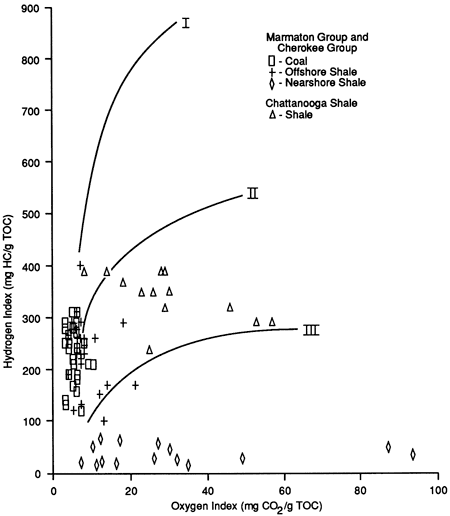
The type of organic matter (as shown by the hydrogen index and the oxygen index) is an indicator of the nature of the hydrocarbon (oil, gas, or both) that would most likely be generated. Type I organic matter generates primarily oil; type II generates both oil and gas, and type III generates primarily gas (Tissot and Welte, 1978, p. 447). The hydrogen and oxygen indexes for the 72 samples from the Cherokee Group and Marmaton Group and the 13 samples from the Chattanooga Shale are listed in appendix 2, plotted in fig. 2, and summarized in table 1. The curved lines in fig. 2 indicate approximate thermal evolution pathways for organic matter types I, II, and III. The hydrogen and oxygen indexes of organic matter in the Chattanooga Shale and in the Cherokee Group and Marmaton Group coals and offshore shale lithofacies plot between type II and type III evolutionary pathways, suggesting that each has the capability to generate oil and natural gas. Organic matter in the nearshore shale lithofacies is degraded type III, indicating that organic matter in these shales has little generating capacity.
Figure 2--Relationship of hydrogrn index to oxygen index for 72 samples from the Cherokee Group and Marmaton Group and 13 samples of Chattanooga Shale from southwestern Missouri, southeastern Kansas, and northeastern Oklahoma. The curved lines (I, II, and III) indicate approximate evolution pathways for different end-member types of sedimentary organic matter.
The main zone of oil generation (oil window) occurs over the vitrinite reflectance range (R0 from 0.5% to 1.3%, which corresponds to Tmax values from 430*deg;C to 460°C (Tissot and Welte, 1978, p. 450-455). Vitrinite reflectance values for eight coal samples from the Cherokee Group and Marmaton Group (table 2) range from 0.53% to 0.80%; Tmax values for 72 shale and coal samples from the Cherokee Group and Marmaton Group range from 430°C to 453°C (appendix 3). These measurements show that organic matter in Cherokee Group and Marmaton Group rocks is thermally mature with respect to petroleum generation in southwestern Missouri, southeastern Kansas, and northeastern Oklahoma. The data presented by Hatch et al. (1984, tables 3 and 4) indicate a higher level of organic matter thermal maturity in the more deeply buried Cherokee Group and Marmaton Group rocks in Osage County, Oklahoma. There, the Tmax values for organic matter in 42 samples of coal and shale from three cores range from 444°C to 474°C, and the vitrinite reflectance values for three coal samples range from 0.87% to 0.97%.
Table 2--Vitrinite reflectance (R0) for eight coal samples from the Cherokee Group and Marmaton Group.
| Sample Number |
Vitrinite Reflectance (% R0)a | Number of Measurements |
Quality (PASLV + PGH)C |
||
|---|---|---|---|---|---|
| Median | Range | Standard Deviation |
|||
| MC168-6 | 0.53 | 0.42-0.61 | 0.03 | 125 | 99699-911 |
| D189091 | 0.65 | 0.54-0.75 | 0.03 | 125 | 97799-313 |
| D196198 | 0.70 | 0.59-0.83 | 0.03 | 127 | 97699-214 |
| 889-72 | 0.68 | 0.55-0.79 | 0.05 | 139 | 87699-513 |
| 1513-13A | 0.57 | 0.48-0.66 | 0.03 | 125 | 97699-213 |
| 1513-27 | 0.63 | 0.47-0.75 | 0.05 | 125 | 97799-313 |
| 1513-79 | 0.73 | 0.58-0.82 | 0.04 | 125 | 97799-313 |
| 1535-146 | 0.80 | 0.66-0.91 | 0.05 | 125 | 75599-512 |
|
Data from Hatch et al. (1984, table 4). Sample locations are listed in appendix 1, sample descriptions in appendix 2. a. Reflectance of vitrinite grains at random orientation, oil immersion objective. b. Range of values, first-cycle vitrinite constituent group. c. Operator subjective evaluation (scale 1-9 of increasing quality or abundance) of polish (P), abundance (A) (in ale preparation), size (S), ease of picking "low-gray" (L) or first-cycle vitrinite, assurance that it is vitrinite (V), plus pyrite (P) in organic grains, organic groundmass (G), and "high-gray" (H) seen but not included in the measurements (inertinite in coals). |
|||||
Organic matter in samples of the Chattanooga Shale from Wabaunsee and Greenwood counties, Kansas, is thermally mature with respect to petroleum generation, as indicated by Tmax values that range from 434°C to 445°C (appendix 3). South of Greenwood County in southeastern Kansas and northeastern Oklahoma, organic matter in the Chattanooga Shale is assumed to be thermally mature because organic matter in the overlying Middle Pennsylvanian shales and coals is thermally mature.
Tissot and Welte (1978, p. 447) suggest the following classification of genetic potential (S1+S2, mg HC/g sample):
Based on this classification, the data summarized in table 1 show that the Cherokee Group and Marmaton Group coals (![]() = 140 mg/g, n = 29) and offshore shales (
= 140 mg/g, n = 29) and offshore shales (![]() = 34 mg/g, n = 24) and the Chattanooga Shale (
= 34 mg/g, n = 24) and the Chattanooga Shale (![]() = 14 mg/g, n = 13) all have good potential to generate hydrocarbons. In contrast, most Cherokee Group and Marmaton Group nearshore shales (
= 14 mg/g, n = 13) all have good potential to generate hydrocarbons. In contrast, most Cherokee Group and Marmaton Group nearshore shales (![]() = 1.6 mg/g, n = 19) have little or no source rock potential. Because these rocks are thermally mature with respect to petroleum generation, some oil and/or natural gas has likely been generated. This implies that the genetic potential for these rocks was originally somewhat higher.
= 1.6 mg/g, n = 19) have little or no source rock potential. Because these rocks are thermally mature with respect to petroleum generation, some oil and/or natural gas has likely been generated. This implies that the genetic potential for these rocks was originally somewhat higher.
Oil-source rock correlations are based on comparisons of the geochemistry of oils with bitumens extracted from potential source rocks. Bitumens and oils are most easily correlated by comparison of saturated hydrocarbon distributions, terpane (m/z = 191) and/or sterane (m/z = 217) distributions, and carbon isotope compositions of saturated and aromatic hydrocarbon fractions. The composition of bitumen reflects the composition of the organic matter in the rock. Organic matter composition is determined by a number of factors, including the relative amounts and compositions of the allochthonous and autochthonous organic matter fractions, the physical and chemical conditions of the depositional environment, the nature of early postdepositional biochemical degradation, and the thermal maturity of the organic matter. For oils these parameters are also affected by biodegradation in the petroleum reservoir and, possibly, distance of oil migration. Detailed discussions of the geologic and geochemical controls of bitumen and oil chemistry are beyond the scope of this study. For an extensive introduction to these topics, refer to texts by Tissot and Welte (1978, 1984) and Hunt (1979), and for an in-depth review of biomarkers, to the article by Mackenzie (1984).
We extracted bitumens from 32 of the 72 samples from the Cherokee Group and Marmaton Group and from 2 Chattanooga Shale samples. We list the total bitumen (mg/kg) contents for these samples in appendix 3. Figure 3 shows representative saturated hydrocarbon distributions from extracts of samples of Cherokee Group and Marmaton Group coals (fig. 3A), offshore shales (fig. 3B), nearshore shales (fig. 3C), the Chattanooga Shale (fig. 3D), and Cherokee Group oils (fig. 3E).
Figure 3--Saturated hydrocarbon distributions from extracts of (A) Cherokee Group coal, (B) Cherokee Group offshore shale, (C) Cherokee Group nearshore shale, (D) Chattanooga Shale, and (E) Cherokee Group oil.
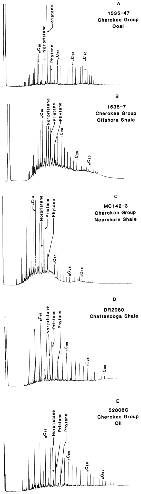
Saturated hydrocarbon distributions for coals (see fig. 3A) are significantly different from Chose of Cherokee Group and Marmaton Group offshore and nearshore shales, the Chattanooga Shale, and Cherokee Group oils (see figs. 3B-E) in that pristane is the dominant compound, the pristane/phytane ratio is high (![]() = 6.0, n = 9; tables 1 and 3), and the C19 to C31 n-alkanes display an odd-carbon predominance. Distributions of the n C15 + saturated hydrocarbons of Cherokee Group and Marmaton Group offshore shales, the Chattanooga Shale, and Cherokee Group oils are similar and are characterized by a predominance of normal alkaes over isoprenoids (e.g., pristane), relatively low pristane/phytane ratios (
= 6.0, n = 9; tables 1 and 3), and the C19 to C31 n-alkanes display an odd-carbon predominance. Distributions of the n C15 + saturated hydrocarbons of Cherokee Group and Marmaton Group offshore shales, the Chattanooga Shale, and Cherokee Group oils are similar and are characterized by a predominance of normal alkaes over isoprenoids (e.g., pristane), relatively low pristane/phytane ratios (![]() = 1.7, n = 15;
= 1.7, n = 15; ![]() = 1.6, n = 2; and
= 1.6, n = 2; and ![]() = 1.6, n = 11, respectively; table 1), and uniformly decreasing amounts of normal alkanes with increasing carbon number. Cherokee Group and Marmaton Group nearshore shales have higher pristane/phytane ratios (
= 1.6, n = 11, respectively; table 1), and uniformly decreasing amounts of normal alkanes with increasing carbon number. Cherokee Group and Marmaton Group nearshore shales have higher pristane/phytane ratios (![]() = 3.9, n = 8) compared with offshore shales, the Chattanooga Shale, and Cherokee Group oils, and the C25 to C31 n-alkanes display an odd-carbon predominance. The saturated hydrocarbon distributions of Cherokee Group and Marmaton Group coals and nearshore shales are dissimilar to those of the Cherokee Group oils, indicating that these lithofacies are not source rocks for these oils.
= 3.9, n = 8) compared with offshore shales, the Chattanooga Shale, and Cherokee Group oils, and the C25 to C31 n-alkanes display an odd-carbon predominance. The saturated hydrocarbon distributions of Cherokee Group and Marmaton Group coals and nearshore shales are dissimilar to those of the Cherokee Group oils, indicating that these lithofacies are not source rocks for these oils.
Table 3--Pristane/phytane ratios for 11 Cherokee Group oils from southeastern Kansas and northeastern Oklahoma.
| Sample Number | Pristane/Phytanea |
|---|---|
| X-628 | 1.6 |
| 58204C | 1.6 |
| 64188C | 1.6 |
| 58201C | 1.6 |
| 58208C | 1.5 |
| 58200C | 1.6 |
| 58203C | 1.7 |
| 58206C | 1.7 |
| 58209C | 1.7 |
| 64249C | 1.6 |
| 58210C | 1.5 |
| Sample locations are listed in appendix 1. a. Pristane/phytane ratios calculated from relative peak heights. |
|
Figure 4 shows representative terpane (m/z = 191) and sterane (m/z = 217) distributions from bitumens extracted from Cherokee Group and Marmaton Group coals (figs. 4A,B), offshore shales (figs. 4C,D), the Chattanooga Shale (figs. 4E,F), and Cherokee Group oils (figs. 4G,H). Terpane and sterane peaks are identified in table 4. Terpane and sterane distributions from Cherokee Group and Marmaton Group nearshore shales are not illustrated here because these shales have minimal potential to generate oil. Terpane distributions from coal (fig. 4A) differ significantly from those of Cherokee Group and Marmaton Group offshore shales (fig. 4C), the Chattanooga Shale (fig. 4E), and Cherokee Group oils (fig. 4G). Coal terpane distributions are characterized by low relative amounts of tricyclic compounds (peaks 1-4 and 6-8) compared with pentacyclic compounds (peaks 9-16) and high relative amounts of C19 and C20 tricyclic, C24 tetracyclic, and C27-17α(H)-tris-norhopane. In contrast, terpane distributions from Cherokee Group and Marmaton Group offshore shales, Cherokee Group oils, and the Chattanooga Shale are characterized by relatively less abundant tricyclic compounds compared with pentacyclic compounds, low relative amounts of C19 tricyclic, C24 tetracyclic, and C27-17α(H)-tris-norhopane, and high relative amounts of C23, C26, C28, and C29 tricyclic compounds.
Figure 4--Terpane (m/z = 191) and sterane (m/z = 217) Ion Fragmentograms for (A,B) Cherokee Group coal, (C,D) Cherokee Group offshore shale, (E,F) Chattanooga Shale, and (G,H) Cherokee Group oil.
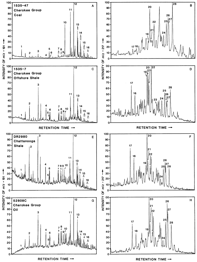
Table 4--Identvmd terpanes and steranes.
| Peak | Compound Name |
|---|---|
| Terpanes | |
| 1 | C19 tricyclic |
| 2 | C21 tricyclic |
| 3 | C23 tricyclic |
| 4 | C25 tricyclic |
| 5 | C24 tetracyclic |
| 6 | C26 tricyclics |
| 7 | C28 tricyclics |
| 8 | C29 tricyclics |
| 9 | C27-18α(H)-tris-norneohopane (TS) |
| 10 | C27-18α(H)-tris-norhopane (TM) |
| 11 | C29 norhopane |
| 12 | C30-17α(H),21β(H)-hopane |
| 13 | C31-17α(H),21β(H)-homohopane (s + r) |
| 14 | C32-17α(H),21β(H)-bis-homohopane (s + r) |
| 15 | C33-17α(H),21β(H)-tris-homohopane (s + r) |
| 16 | C34-17α(H),21β(H)-tetrakishomohopane (s + r) |
| Steranes | |
| 17 | C27-13β,17α-diacholestane (20S) |
| 18 | C27-13β,17α-diacholestane (20R) |
| 19 | C27-14α,17α-cholestane (20S) |
| 20 | C27-14β,17β-cholestane (20R) + C29-24-ethyl-13β,17α-diacholestane |
| 21 | C27-14β,17β-cholestane (20S) |
| 22 | C27-14α,17α-cholestane (20R) |
| 23 | C28-14α,17α-24-methy-cholestane (20S) |
| 24 | C28-14α,17α-24-methyl-cholestane (20R) |
| 25 | C29-14α,17α-24-ethyl-cholestane (20S) |
| 26 | C29-14β,17β-24-ethyl-cholestane (20R) |
| 27 | C29-14β,17β-24-ethyl-cholestane (20S) |
| 28 | C29-14α,17α-24-ethyl-cholestane (20R) |
Sterane distributions differ significantly in the relative amounts of C27-13β,17α-diacholestanes (peaks 17 and 18) and C27-14α, 17α-cholestanes (peaks 19 and 22). Sterane distributions from Cherokee Group and Marmaton Group coals (fig. 4B) are characterized by low relative amounts of C27-13β,17α-diacholestanes and C27-14α,17α-cholestanes; Cherokee Group and Marmaton Group offshore shales (fig. 4D) are characterized by intermediate amounts of C27-13β,17α-diacholestanes and high amounts of C27-14α,17α-cholestanes; and the Chattanooga Shale and the Cherokee Group oils (figs. 4F and 4H, respectively) are characterized by intermediate amounts of C27-13β,17α-diacholestanes and C27-14α,17α-cholestanes.
The carbon isotope compositions of the saturated and aromatic hydrocarbon fractions from oils and rock extracts are listed in table 5, summarized in table 1, and illustrated in figure 5. The carbon isotope values exhibit a range, with saturated hydrocarbon fractions from Cherokee Group and Marmaton Group coals the most enriched in 13C (![]() δ13Csat = -27.3‰, n = 3). Cherokee Group and Marmaton Group offshore shales less enriched (
δ13Csat = -27.3‰, n = 3). Cherokee Group and Marmaton Group offshore shales less enriched (![]() δ13Csat = -28.4‰, n = 4 ). and Chattanooga Shale and Cherokee Group oils least enriched (
δ13Csat = -28.4‰, n = 4 ). and Chattanooga Shale and Cherokee Group oils least enriched (![]() δ13Csat = -29.2‰, n = 2; and
δ13Csat = -29.2‰, n = 2; and ![]() δ13Csat = -30.0‰, n = 6, respectively). Aromatic hydro- carbon fractions show similar trends, with fractions from Cherokee Group and Marmaton Group coals the most enriched in 13C (
δ13Csat = -30.0‰, n = 6, respectively). Aromatic hydro- carbon fractions show similar trends, with fractions from Cherokee Group and Marmaton Group coals the most enriched in 13C (![]() δ13Carom= -25.8‰, n = 3), Cherokee Group and Marmaton Group offshore shales less enriched (
δ13Carom= -25.8‰, n = 3), Cherokee Group and Marmaton Group offshore shales less enriched (![]() δ13Carom = -27.9‰, n = 4), and Chattanooga Shale and Cherokee Group oils the least enriched (
δ13Carom = -27.9‰, n = 4), and Chattanooga Shale and Cherokee Group oils the least enriched (![]() δ13Carom = -28.5‰, n = 2; and
δ13Carom = -28.5‰, n = 2; and ![]() δ13Carom = -28.9‰, n = 6, respectively).
δ13Carom = -28.9‰, n = 6, respectively).
Figure 5--δ13C of saturated and aromanc hydrocarbon fractions from Marmaton Group, Cherokee Group, and Chattanooga Shale rock extracts and Cherokee Group oils.
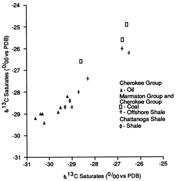
Cherokee Group oils and extracts of the Chattanooga Shale have similar saturated hydrocarbon distributions, pristane/phytane ratios, and terpane and sterane distributions, suggesting that the Chattanooga Shale is the source rock for the oils. Saturated hydrocarbon distributions, pristane/phytane ratios, and terpane and sterane distributions from extracts of Cherokee Group and Marmaton Group coals are dissimilar to Cherokee Group oils. The primary geochemical mismatch between extracts of Cherokee Group and Marmaton Group offshore shales and Cherokee Group oils is the sterane distribution. In addition, the carbon isotope compositions of the saturated and aromatic hydrocarbon fractions from the Cherokee oils are closer to the isotope compositions of extracts of the Chattanooga Shale than to those of extracts of Cherokee Group and Marmaton Group offshore shales and coals.
The correlation established between Cherokee Group oils and the Chattanooga Shale implies that, if continuous porosity trends and migration pathways exist in the Mississippian carbonates above and/or in the Paleozoic section immediately below the Chattanooga Shale in southeastern Kansas and northeastern Oklahoma and if trapping conditions are present, the porosity can be charged with oil derived from the Chattanooga Shale. A second implication of this study is that, even though the Cherokee Group and Marmaton Group coals and offshore shales are not the source rocks of the Cherokee Group oils, these rocks have excellent remaining generation potential and may be source rocks for other midcontinent oils and/or natural gases.
Table 5--δ13C analyses of saturated hydrocarbon and aromatic hydrocarbon fractions from extracts from nine shales and coals from the Cherokee Group and Marmaton Group, extracts of two shale samples from the Chattanooga Shale, and seven Cherokee Group oils. Cherokee Group oil and Cherokee Group and Marmaton Group extract data from Hatch et al. (1984, table 7). Sample locations are listed in appendix 1; sample descriptions in appendix 2. HC = hydrocarbons.
| Sample Number |
δ13C for Saturated HC (‰)a |
δ13C for Aromatic HC (‰)a |
|---|---|---|
| Cherokee Group and Marmaton Group | ||
| MC121-4 | -26.6 | -24.9 |
| D189091 | -28.6 | -26.6 |
| 349-3 | -27.4 | -27.6 |
| 1535U-25 | -28.7 | -28.0 |
| 1535-12 | -26.8 | -26.0 |
| 1535-13A | -26.8 | -25.6 |
| 1535-23 | -26.5 | -26.2 |
| 1535-25 | -28.3 | -27.4 |
| 1615-6 | -29.0 | -28.7 |
| Chattanooga Shale | ||
| DR2980 | -29.1 | -28.4 |
| STA2319 | -29.3 | -28.7 |
| Cherokee Group oils | ||
| X-628 | -29.6 | -28.9 |
| 58204 | -30.2 | -29.4 |
| 58208 | -30.3 | -29.0 |
| 58200 | -30.6 | -29.2 |
| 58206 | -29.2 | -28.2 |
| 58209 | -29.5 | -28.7 |
| 64249 | -30.4 | -29.0 |
| a. Relative to the PDB marine-carbonate standard. | ||
Special thanks go to George E. Claypool, who originally suggested the study and provided much encouragement. We would like to recognize the following organizations for their active support in the acquisition of core and oil samples: Marathon Oil Company, Littleton, Colorado; Missouri Department of Natural Resources, Division of Geology and Land Survey, Rolla, Missouri; and the Kansas Geological Survey, Lawrence, Kansas. Some of the geochemical analyses were provided by Sister Carlos M. Lubeck, Mark J. Pawlewicz, Charles N. Threlkeld, and April K. Vuletich. The illustrations were originally drafted by William J. Betterton and revised by Mark Schoneweis. Earlier drafts of this manuscript have benefited from reviews by Collin Barker, Wallace G. Dow, W. Lynn Watney, K. David Newell, Jerry L. Clayton, and Charles W. Holmes. Trade and company names are for descriptive purposes only and do not imply endorsement by the U.S. Geological Survey or the Kansas Geological Survey.
Locations and sampled intervals for 72 samples from the Middle Pennsylvanian (Desmoinesian) Cherokee Group and Marmaton Group, 13 samples of Devonian-Kinderhookian Chattanooga Shale, and 11 samples of Cherokee Group oils. Data on Cherokee Group oils and Cherokee Group and Marmaton Group rocks from Hatch et al. (1984, tables 2 and 1, respectively). - indicates no data.
| Index Map Number |
Core or Sample Number |
Location | Depth Interval (Number of Samples or Producing Interval) |
|---|---|---|---|
| Cherokee Group and Marmaton Group | |||
| 1 | MC 121 | SW sec. 1, T. 40 N., R. 32 W., Bates County, Missouri |
56.6-98.7 ft (5 core samples) |
| 2 | MC 142 | SW sec. 29, T. 39 N., R. 30 W., Bates County, Missouri |
85.0-88.0 ft (2 core samples) |
| 3 | M-7-65 | NE sec. 30, T. 40 N., R. 27 W., Henry County, Missouri |
strip mine (1 channel sample) |
| 4 | MC 168 | SE sec. 35, T. 37 N., R. 30 W., Vernon County, Missouri |
53.3-59.6 ft (4 core samples) |
| 5 | D189091 | SE sec. 21, T. 26 S., R. 25 E., Bourbon County, Kansas |
strip mine (1 channel sample) |
| 6 | D196198 | SE sec. 2, T. 31 S., R. 25 E., Crawford County, Kansas |
strip mine (1 channel sample) |
| 7 | PM-6 | SE sec. 8, T. 32 S., R. 22 E., Cherokee County, Kansas |
44.4-349.3 ft (6 core samples) |
| 8 | 871C, J. W. Martindell No. 52 | NW sec. 3 1, T. 23 S., R. 10 E., Greenwood County, Kansas |
2062-2097 ft (2 core samples) |
| 9 | 349C, J. W. Martindell No. 50 | SW sec. 3 1, T. 23 S., R. 10 E., Greenwood County, Kansas |
2090-2289 ft (6 core samples) |
| 10 | 889C, Teter No. 4 | NE sec. 6, T. 24 S., R. 10 E., Greenwood County, Kansas |
23 69-2401 ft (4 core samples) |
| 11 | 1535C, Rexwinkle No. 1 | SE sec. 30, T. 29 N., R. 18 E., Craig County, Oklahoma |
95.3-766 ft (21 core samples) |
| 12 | 1615C, Kelly No. 1 | W sec. 23, T. 20 N., R. 14 E., Rogers County, Oklahoma |
187-1096 ft (19 core samples) |
| Chattanooga Shale | |||
| 13 | Davis A No. 2 | SW sec. 33, T. 13 S., R. 10 E., Wabaunsee County, Kansas |
2977-2980 ft (2 core samples) |
| 14 | ERDA Stauffer No. 1 | NE sec. 20, T. 23 S., R. 12 E., Greenwood County, Kansas |
2313-2322 ft (5 core samples) |
| 15 | ERDA Bock No. 1 | NE sec. 15, T. 23 S., R. 12 E., Greenwood County, Kansas |
2164-2176 ft (6 core samples) |
| Cherokee Group oils | |||
| 16 | X-628, Headley "A" 1-9, Winterscheid field |
sec. 29, T. 23 S., R. 14 E., Woodson County, Kansas |
- (Bartlesville sand) |
| 17 | 58204C, Cities Service Teeter No. 37, Teeter field |
NW sec. 15, T. 23 S., R. 9 E., Greenwood County, Kansas |
2349 ft (Burbank sand) |
| 18 | 64188C, Phillips Petroleum Cannon No. 14, Thrall field |
W sec. 12, T. 24 S., R. 9 E., Greenwood County, Kansas |
- (Cherokee sand) |
| 19 | 58201C, Texas Co. C. J. Gulick, Burden field |
NE sec. 32, T. 31 S., R. 6 E., Cowley County, Kansas |
2200 ft (Burbank sand) |
| 20 | 58208C, Morrison Producing, Haverhill field |
SW sec. 35, T. 28 S., R. 5 E., Butler County, Kansas |
- (Burbank sand) |
| 21 | 58200C, Texas Company No. 4, Burbank S. field |
NE sec. 30, T. 25 N., R. 8 E., Osage County, Oklahoma |
2470 ft (Burgess sand) |
| 22 | 58203C, Nadel, Gussman and Sinclair Mayer No. 10, Simon Lebow field |
SE sec.19, T. 25 N., R. 9 E., Osage County, Oklahoma |
2300 ft (Mississippian chat) |
| 23 | 58206C, General American Soldani No. 1, Olsen field |
SW sec. 24, T. 26 N., R. 4 E., Osage County, Oklahoma |
3 100 ft (Prue or Squirrel sand) |
| 24 | 58209C, Layton No. 30 Pershing field |
sec. 36, T. 25 N., R. 9 E., Osage County, Oklahoma |
2001 ft (Bartlesville sand) |
| 25 | 64249, SW Bartlesville unit |
T. 26-28 N., R. 12-14 E., Washington County, Oklahoma |
- (Bartlesville sand) |
| 26 | 58210C, Sunray Midcontinent H. Spybuck, Sperry field |
NW sec. 24, T. 21 N., R. 12 E., Tulsa County, Oklahoma |
1217 ft (Burgess sand) |
Sample numbers, lithologies, umofacies, and deprh u4tervais or tiuckness for 72 rock samples from the Middle Pennsylvanian, Cherokee, and Marmaton groups, and 13 rock samples from the Late Devonian-Kinderhookian Chattanooga Shale, southwestern Missouri, southeastern Kansas, and northeastern Oklahoma. Locations are listed in appendix 1. Cherokee and Marmaton Group data are from Hatch et al. (1984, table 1. 1 ft = 0.3048 m. - indicates no data or not applicable.
| Sample Number | Lithology | Lithofaciesa | Depth Interval or Thickness (ft) |
Notes |
|---|---|---|---|---|
| Cherokee Group and Marmaton Group | ||||
| MC121-2 | Shale, N2, phosphatic | Offshore shale | 62.3-63.1 | Anna shale |
| MC121-3 | Shale, N2 | Offshore shale | 63.6-65.1 | |
| MC121-4 | Coal | Nearshore shale | 73.3-73.8 | Lexington coal |
| MC121-5 | Shale, N3, fossiliferous | Nearshore shale | 76.8-81.2 | |
| MC121-7 | Coal | Nearshore shale | 83.7-83.9 | |
| MC142-3 | Shale, N2 | Nearshore shale | 85.0-88.0 | |
| MC142-4 | Coal | Nearshore shale | 88.0-89.4 | Robinson Branch coal |
| M7-65 | Shale, N2, phosphatic | Offshore shale | 0.5 | Seahorne shale |
| MC168-4 | Shale, N3 | Nearshore shale | 53.3-59.6 | |
| MC168-5 | Shale, N2, phosphatic | Offshore shale | 60.7-62.4 | |
| MC168-6 | Coal | Nearshore shale | 62.6-64.1 | |
| MC168-7 | Shale, N3 | Nearshore shale | 80.0-86.5 | |
| D189091 | Coal | Nearshore shale | 1.2 | Mulky coal |
| D196198 | Coal | Nearshore shale | 1.5 | Bevier coal |
| 6-1 | Shale, N2-N1 | Offshore shale | 44.4-49.6 | Verdigris shale |
| 6-2 | Coal | Nearshore shale | 52.0-52.7 | Croweburg coal |
| 6-12 | Shale | Nearshore shale | 150.7-152.3 | |
| 6-13 | Coal | Nearshore shale | 152.3-153.0 | Tebo coal |
| 6-27 | Shale | Nearshore shale | 346.7-348.5 | |
| 6-28 | Coal | Nearshore shale | 348.5-349.3 | |
| 871-3 | Coal | Nearshore shale | 2062.0-2062.9 | |
| 871-12 | Shale, N2, phosphatic | Offshore shale | 2095.7-2097.0 | Excello shale |
| 349-3 | Shale, N2 | Offshore shale | 2095.1-2096.1 | Excello shale |
| 349-17 | Shale, N2 | Nearshore shale | 2121.7-2122.7 | |
| 349-38 | Coal | Nearshore shale | 2213.0-2213.1 | |
| 349-46 | Shale, N2-N3 | Offshore shale | 2225.0-2226.4 | Verdigris shale |
| 349-57 | Shale, N2. phosphatic | Offshore shale | 2252.8-2253.9 | |
| 349-69 | Shale, N2 | Offshore shale | 2288.7-2289.3 | |
| 889-44 | Shale, N3 | Offshore shale | 2368.7-2374.3 | |
| 889-61 | Coal | Nearshore shale | 2391.2-2392.1 | |
| 889-71 | Shale, N3, fossiliferous | Nearshore shale | 2400.0-2400.3 | |
| 889-72 | Coal | Nearshore shale | 2400.3-2401.1 | |
| 1535u-5 | Shale, N1-N2 | Offshore shale | 95.3-97.1 | Anna shale |
| 1535u-8 | Coal | Nearshore shale | 98.0-99.0 | Lexington coal |
| 1535u-23a | Shale, N2. calcareous | Offshore shale | 200.7-200.8 and 202.7-202.8 |
Shaly partings in Higginsville limestone |
| 1535u-25 | Shale, N2 | Offshore shale | 229.6-235.5 | Little Osage shale |
| 1535-7 | Shale, N2, phosphatic | Offshore shale | 280.1-285.2 | Excello shale |
| 1535-12 | Shale, N2-N3, calcareous, phosphatic |
Offshore shale | 304.0-306.7 | |
| 1535-13a | Coal | Nearshore shale | 307.1-308.0 | Bevier coal |
| 1535-23 | Shale, N2-N3, phosphatic |
Offshore shale | 331.8-333.2 | |
| 1535-25 | Shale, N2, phosphatic | Offshore shale | 334.6-336.1 | Verdigris shale |
| 1535-27 | Coal | Nearshore shale | 342.3-344.0 | Croweburg coal, 0.15 ft recovered |
| 1535-47 | Coal | Nearshore shale | 389.1-390.4 | |
| 1535-66 | Shale, N2, phosphatic | Offshore shale | 440.7-441.7 | Seahorne shale (?) |
| 1535-69 | Coal | Nearshore shale | 445.0-446.0 | Bottom 0.1 ft recovered |
| 1535-78 | Shale, N2 | Nearshore shale | 503.0-503.6 | |
| 1535-79 | Coal | Nearshore shale | 503.6-506.7 | Top 0.8 ft recovered |
| 1535-107 | Shale, N2-N3 | Nearshore shale | 588.9-600.0 | Bottom 2.5 ft lost |
| 1535-144 | Shale, N3 | Nearshore shale | 685.4-690.7 | |
| 1535-146 | Coal, shaly | Nearshore shale | 691.5-692.5 | Top 0.2 and bottom 0.3 ft sampled |
| 1535-150 | Coal | Nearshore shale | 699.3-700.1 | |
| 1535-159 | Shale, N2-N3 | Nearshore shale | 711.9-725.5 | |
| 1535-187 | Coal, shaly | Nearshore shale | 765.4-765.7 | |
| 1615-3 | Shale, N2, phosphatic | Offshore shale | 186.9-189.4 | Little Osage shale |
| 1615-6 | Shale, N2, phosphatic | Offshore shale | 208.4-210.9 | Excello shale |
| 1615-12 | Coal | Nearshore shale | 221.3-221.9 | |
| 1615-53 | Shale, N2-N3 | Offshore shale | 299.7-301.9 | Verdigris shale |
| 1615-56 | Coal | Nearshore shale | 320.0-321.7 | Croweburg coal |
| 1615-136 | Shale, N3, phosphatic | Offshore shale | 532.4-533.1 | |
| 1615-191 | Shale, N2, phosphatic | Offshore shale | 649.9-652.0 | 1615-191 and 1615-192 combined |
| 1615-193 | Shale, N2, fossiliferous | Nearshore shale | 652.0-652.4 | |
| 1615-194 | Coal | Nearshore shale | 652.4-652.9 | |
| 1615-236 | Shale, N3 | Nearshore shale | 766.9-772.0 | |
| 1615-237 | Shale, N2, phosphatic | Offshore shale | 772.0-772.4 | |
| 1615-264 | Shale, N3 | Nearshore shale | 851.4-851.7 | |
| 1615-265 | Shale, N2, phosphatic | Offshore shale | 851.7-851.9 | |
| 1615-267 | Coal | Nearshore shale | 852.0-852.2 | |
| 1615-290 | Shale, N2, calcareous | Offshore shale | 890.9-891.6 | |
| 1615-292 | Coal | Nearshore shale | 893.4-894.3 | |
| 1615-341 | Coal | Nearshore shale | 1023.0-1024.4 | |
| 1615-382 | Shale, N3, calcareous | Nearshore shale | 1090.9-1095.7 | |
| 1615-384 | Coal | Nearshore shale | 1095.7-1096.0 | |
| Chattanooga Shale | ||||
| DR2977 | Shale, N2 | - | 2977.0-2977.2 | Two samples basal 3.0 ft of shale |
| DR2980 | Shale, N1 | - | 2980.0-2980.2 | |
| STA2313 | Shale, N1 | - | 2313.0-2313.2 | Five samples from basal 9.0 ft of shale |
| STA2315 | Shale, N1 | - | 2315.0-2315.2 | |
| STA2316 | Shale, N1 | - | 2316.0-2316.2 | |
| STA2318 | Shale, N1 | - | 2318.0-2318.2 | |
| STA2319 | Shale, N1 | - | 2319.0-2319.2 | |
| BOC2164 | Shale, N1 | - | 2164.0-2164.2 | Six samples from basal 12.0 ft of shale |
| BOC2166 | Shale, N1 | - | 2166.0-2166.2 | |
| BOC2168 | Shale, N1 | - | 2168.0-2168.2 | |
| BOC2170 | Shale, N1 | - | 2170.0-2170.2 | |
| BOC2172 | Shale, N1 | - | 2172.0-2172.2 | |
| BOC2174 | Shale, N1 | - | 2174.0-2174.2 | |
| a. Lithofacies of Middle Pennsylvanian samples described by Heckel (1977) and Ebanks et al. (1979). | ||||
Organic carbon content, Rock-Eval analysis, and extract composition for 72 rock samples from the Middle Pennsylvanian Cherokee Group and Marmaton Group and 13 rock samples from the Late Devonian-Kinderhookian Chattanooga Shale, southwestern Missouri, southeastern Kansas, and northeastern Oklahoma.
| Sample Number |
Organic Carbon (%)a |
Temperature of Maximum Yield (°C)b |
Hydrogen Index (mg HC/g TOC)C |
Oxygen Index (mg CO2/g TOC)d |
Genetic Potential (mg HC/g sample)e |
Bitumen (mg/kg) |
Pristane/ Phytane Ratiof |
|---|---|---|---|---|---|---|---|
| Cherokee Group and Marmaton Group | |||||||
| MC121-2 | 19.7 | 439 | 400 | 7 | 83 | 6700 | 1.4 |
| MC121-3 | 9.9 | 441 | 220 | 7 | 23 | 2000 | 1.8 |
| MC121-4 | 61.0 | 436 | 230 | 5 | 150 | 9400 | 6.7 |
| MC121-5 | 1.7 | 436 | 17 | 16 | 0.36 | - | - |
| MC121-7 | 50.4 | 441 | 250 | 8 | 120 | - | - |
| MC142-3 | 6.0 | 433 | 21 | 12 | 1.6 | - | 3.3 |
| MC142-4 | 76.6 | 435 | 210 | 9 | 160 | - | - |
| M-7-65 | 20.1 | 441 | 290 | 18 | 61 | 5100 | 1.4 |
| MC168-4 | 2.4 | 442 | 28 | 49 | 0.80 | - | 4.4 |
| MC168-5 | 18.0 | 443 | 230 | 8 | 44 | 4300 | 1.5 |
| MC168-6 | 74.3 | 430 | 310 | 6 | 240 | 25,000 | 6.6 |
| MC168-7 | 1.7 | 442 | 25 | 32 | 0.54 | - | - |
| D189091 | 69.6 | 440 | 310 | 5 | 210 | 17,200 | 1.8 |
| D196198 | 72.2 | 440 | 220 | 5 | 170 | - | - |
| 6-1 | 9.4 | 444 | 190 | 4 | 20 | - | - |
| 6-2 | 40.9 | 438 | 250 | 4 | 100 | - | - |
| 6-12 | 8.5 | 446 | 120 | 5 | 11 | - | - |
| 6-13 | 66.0 | 450 | 280 | 3 | 190 | - | - |
| 6-27 | 3.0 | 440 | 62 | 17 | 2.2 | - | - |
| 6-28 | 65.5 | 449 | 290 | 3 | 200 | - | - |
| 871-3 | 59.5 | 440 | 190 | 6 | 120 | - | - |
| 871-12 | 18.9 | 442 | 310 | 6 | 62 | - | - |
| 349-3 | 21.6 | 440 | 280 | 6 | 64 | 6300 | 1.7 |
| 349-17 | 4.5 | 450 | 14 | 11 | 0.88 | - | - |
| 349-38 | 47.0 | 445 | 230 | 5 | 120 | - | - |
| 349-46 | 14.9 | 449 | 260 | 11 | 41 | 3800 | 1.9 |
| 349-57 | 8.1 | 446 | 170 | 14 | 15 | 2800 | 2.0 |
| 349-69 | 9.0 | 447 | 170 | 21 | 18 | - | - |
| 889-44 | 3.7 | 452 | 100 | 13 | 4.2 | 530 | 4.5 |
| 889-61 | 68.6 | 438 | 270 | 4 | 200 | - | - |
| 889-71 | 2.8 | 447 | 19 | 7 | 0.68 | - | - |
| 889-72 | 67.7 | 443 | 190 | 4 | 140 | - | - |
| 1535u-5 | 9.5 | 443 | 440 | 8 | 24 | - | - |
| 1535u-8 | 39.9 | 439 | 290 | 6 | 120 | - | - |
| 1535u-23a | 7.6 | 441 | 270 | 4 | 24 | - | - |
| 1535u-25 | 11.0 | 445 | 230 | 6 | 27 | 3500 | 1.5 |
| 1535-7 | 14.8 | 447 | 260 | 8 | 40 | 3100 | 1.7 |
| 1535-12 | 4.7 | 449 | 130 | 7 | 7.0 | 1200 | 2.4 |
| 1535-13a | 73.0 | 442 | 210 | 10 | 160 | 13,000 | 6.5 |
| 1535-23 | 7.2 | 444 | 120 | 5 | 10 | 1500 | 2.0 |
| 1535-25 | 14.6 | 448 | 290 | 7 | 45 | 5300 | 1.6 |
| 1535-27 | 35.3 | 445 | 160 | 6 | 57 | - | - |
| 1535-47 | 65.9 | 447 | 240 | 6 | 170 | 7800 | 8.6 |
| 1535-66 | 7.9 | 437 | 150 | 12 | 13 | - | - |
| 1535-69 | 61.1 | 452 | 240 | 4 | 160 | - | - |
| 1535-78 | 10.3 | 444 | 50 | 10 | 5.8 | 2500 | 5.2 |
| 1535-79 | 68.4 | 446 | 180 | 6 | 120 | 9300 | 7.5 |
| 1535-107 | 2.7 | 446 | 46 | 87 | 1.5 | 620 | 3.0 |
| 1535-144 | 1.7 | 449 | 12 | 35 | 0.33 | 450 | 2.9 |
| 1535-146 | 33.4 | 445 | 130 | 3 | 47 | 2800 | 5.2 |
| 1535-150 | 55.6 | 453 | 120 | 7 | 73 | - | - |
| 1535-159 | 2.7 | 450 | 29 | 93 | 1.0 | - | - |
| 1535-187 | 42.4 | 453 | 210 | 5 | 95 | - | - |
| 1615-3 | 17.2 | 448 | 280 | 5 | 52 | 5500 | 1.6 |
| 1615-6 | 15.7 | 438 | 290 | 5 | 48 | 4300 | 1.6 |
| 1615-12 | 69.6 | 443 | 280 | 5 | 190 | - | - |
| 1615-53 | 12.4 | 444 | 260 | 6 | 34 | 4700 | 1.7 |
| 1615-56 | 76.1 | 452 | 170 | 5 | 130 | 5800 | 5.8 |
| 1615-136 | 7.3 | 443 | 260 | 11 | 21 | - | - |
| 1615-191 | 10.1 | 448 | 230 | 7 | 25 | - | - |
| 1615-193 | 3.9 | 453 | 65 | 12 | 3.1 | - | - |
| 1615-194 | 57.5 | 446 | 270 | 6 | 170 | - | - |
| 1615-236 | 1.2 | 445 | 26 | 26 | 0.45 | - | - |
| 1615-237 | 14.9 | 445 | 210 | 7 | 34 | 5800 | 2.0 |
| 1615-264 | 2.0 | 449 | 45 | 30 | 1.1 | - | - |
| 1615-265 | 12.5 | 448 | 260 | 7 | 34 | - | - |
| 1615-267 | 56.2 | 447 | 140 | 3 | 80 | - | - |
| 1615-290 | 21.0 | 448 | 240 | 6 | 55 | 3300 | 4.6 |
| 1615-292 | 62.7 | 447 | 250 | 3 | 160 | 7400 | 5.1 |
| 1615-341 | 66.7 | 454 | 240 | 4 | 160 | - | - |
| 1615-382 | 4.1 | 449 | 57 | 27 | 2.6 | - | - |
| 1615-384 | 44.1 | 448 | 270 | 4 | 120 | - | - |
| Chattanooga Shale | |||||||
| DR2977 | 1.9 | 434 | 240 | 25 | 5.6 | - | - |
| DR2980 | 3.4 | 438 | 390 | 8 | 15 | 4000 | 1.6 |
| STA2313 | 4.1 | 443 | 320 | 29 | 15 | - | - |
| STA2315 | 4.1 | 445 | 370 | 18 | 17 | - | - |
| STA2316 | 3.1 | 442 | 290 | 57 | 10 | - | - |
| STA2318 | 5.0 | 444 | 390 | 14 | 22 | 5300 | 1.6 |
| STA2319 | 4.2 | 442 | 350 | 23 | 16 | - | - |
| BOC2164 | 2.9 | 445 | 390 | 29 | 13 | - | - |
| BOC2166 | 3.7 | 444 | 390 | 28 | 16 | - | - |
| BOC2168 | 4.0 | 444 | 350 | 26 | 16 | - | - |
| BOC2170 | 3.2 | 443 | 350 | 30 | 12 | - | - |
| BOC2172 | 4.2 | 444 | 320 | 46 | 15 | - | - |
| BOC2174 | 3.6 | 445 | 290 | 53 | 12 | - | - |
|
Locations listed in appendix 1; sample descriptions in appendix 2. Cherokee Group and Marmaton Group data are from Hatch et al. (1984, tables 3 and 6). HC = hydrocarbons; TOC = total organic carbon. - indicates no data. a. Air-dried basis. b. Temperature at which the yield of pyrolysis products (S2) is at a maximum (Tmax). c. S2/TOC. d. S3/TOC. e. S1 + S2. f. Ratios calculated from relative peak heights above base line. |
|||||||
Adler, R J., Caplan, W. M., Carlson, M. R, Goebel, E. D., Henslee, H. T., Hicks, I. C., larson, T. G., McCracken, M. H., Parker, M. C., Rascoe, B., Jr., Schramm, M. W., Jr., and Wells, J. S., 1971, Future petroleum provinces of the midcontinent, region 7; in, Future Petroleum Provinces of the United States: American Association of Petroleum Geologists, Memoir 15, p. 985-1120.
Baker, D. R., 1962, Organic geochemistry of the Cherokee Group in southeastern Kansas and northeastern Oklahoma: American Association of Petroleum Geologists, Bulletin, v. 46, p. 16211642.
Baker, D. R., and Ferguson, W. S., 1964, Stable carbon isotopes in petroleum and sediment hydrocarbons from the Cherokee petroleum province: Geological Society of America, Program, 1964 Annual Meeting, p. 7.
Baker, D. R., Ferguson, W. S., and Claypool, G. E., 1969, Organic geochemistry and petroleum distribution on the Cherokee platform, Kansas and Oklahoma: American Association of Petroleum Geologists, Bulletin, v. 53, p. 704-705.
Bass, N. W., 1936, Origin of the shoestring sands of Greenwood and Butler counties, Kansas: Kansas Geological Survey, Bulletin 23, 135 p. [available online]
Bostick, N. A., and Alpern, B., 1977, Principles of sampling, preparation, and constituent selection for microphotometry in measurement of maturation of sedimentary organic matter: Journal of Microscopy, v. 109, pt. 1, p. 41-47.
Bush, P. R., 1970, A rapid method for determination of carbonate carbon and organic carbon: Chemical Geology, v. 6, p. 59-62.
Clark, F. R., 1934, Origin and accumulation of oil; in, Problems of Petroleum Geology: American Association of Petroleum Geologists, Tulsa, Oklahoma, p. 309-334.
Coveney, R. M., Jr., Leventhal, J. S., Glascock, M. D., and Hatch, J. R., 1987, Origins of metals and organic matter in the Mecca Quarry Shale Member and stratigraphically equivalent beds across the Midwest: Economic Geology, v. 82, p. 915-933.
Ebanks, W. J., Jr., Brady, L. L, Heckel, P. H., O'Connor, H. G., Sanderson, G. A., West, R. R., and Wilson, F. W., 1979, The Mississippian and Pennsylvanian (Carboniferous) systems in the United States-Kansas: U.S. Geological Survey, Professional Paper 1110-Q, p. Q1-Q30.
Espitalié, J., Laporte, J. L., Madec, M., Marquis, F., Leplat, P., Paulet, J., and Boutefeu, A., 1977, Méthode rapide de caractérisation des roches mères, et de leur potentiel pétrolier et de leur degré d'évolution: Revue de l'Institut Francais de Pétrole, v. 32, p. 23-42.
Hatch, J. R., and Leventhal, J. S., 1981, Geochemistry of organic rich shales and coals from the Middle Pennsylvanian Cherokee Group and lower part of the Marmaton Group, Oklahoma, Kansas, Missouri, and Iowa: American Association of Petroleum Geologists, Bulletin, v. 65, p. 936.
Hatch, J. R., and Leventhal, J. S., 1982, Comparative organic geochemistry of shales and coals from the Cherokee Group and lower part of the Marmaton Group of Middle Pennsylvanian age, Oklahoma, Kansas, Missouri, and Iowa: American Association of Petroleum Geologists Bulletin, v. 66, p. 579.
Hatch, J. R., and Leventhal, J. S., 1985, Organic and trace-element geochemical evidence of depositional and post-depositional processes for Middle and Upper Pennsylvanian organic-matter-rich rocks; in, Recent Interpretations of Late Paleozoic Cyclothems, W. L. Watney, R. L. Kasler, and K. D. Newell, eds.: Proceedings of Midcontinent Section SEPM Third Annual Meeting and Field Conference, p. 267-268.
Hatch, J. R., Daws, T. A., Lubeck, Sister C. M., Pawlewicz, M. J., Threlkeld, C. N., and Vuletich, A. K., 1984, Organic geochemical analyses for 247 organic-rich rocks and 11 oil samples from the Middle Pennsylvanian Cherokee and Marmaton groups, southeastern Iowa, Missouri, southeastern Kansas, and northeastern Oklahoma: U.S. Geological Survey, Open-file Report 84-160, 39 p. [available online]
Heckel, P. H., 1977, Origin of phosphatic black shale facies in Pennsylvanian cyclothems of midcontinent North America: American Association of Petroleum Geologists, Bulletin, v. 61, p. 1045-1068.
Hedberg, H. D., 1964, Geologic aspects of origin of petroleum: American Association of Petroleum Geologists, Bulletin, v. 48, p. 1755-1803.
Hunt, J. M., 1979, Petroleum geochemistry and geology: W. H. Freeman, San Francisco, 615 p.
James, G. W., 1970, Stratigraphic geochemistry of a Pennsylvanian black shale (Excello) in the midcontinent and Illinois basin: Ph.D. dissertation, Rice University, Houston, Texas, 102 p.
James, G. W., and Baker, D. R., 1972, Organic geochemistry of a Pennsylvanian black shale (Excello) in the midcontinent and the Illinois basin; in, Short Papers on Research in Kansas: Kansas Geological Survey, Bulletin 204, p. 3-10. [available online]
King, P. B., Beikman, H. M., and Edmonston, G. J., 1974, Geologic map of the United States: U.S. Geological Survey, scale 1:2,500,000.
Mackenzie, A. S., 1984, Applications of biological markers in petroleum geocheinistry; in, Advances in Petroleum Geochemistry, J. Brooks and D. Welte, eds., Academic Press, London, v. 1, p. 115-214.
McCoy, A. W., and Keyte, W. R., 1934, Present interpretations of the structural theory for oil and gas migration and accumulation; in, Problems of Petroleum Geology: American Association of Petroleum Geologists, Tulsa, Oklahoma, p. 253-307.
Orr, W. L., 1983, Comments on pyrolytic hydrocarbon yields in source-rock evaluation; in, Advances in Organic Geochemistry 1981, M. Bjoroy, P. Albrecht, C. Comford, K. de Groot, G. Eglinton, E. Galimov, D. Leydiaeuser, R. Pelet, J. Rullkötter, and G. Speers, eds.: John Wiley and Sons, New York, p. 775-787.
Ronov, A. B., 1958, Organic carbon in sedimentary rocks (in relation to presence of petroleum): Translations in Geochemistry, v. 5, p. 510-536.
Tissot, B. P., and Welte, D. H., 1978, Petroleum formation and occurrence--a new approach to oil and gas exploration: Springer-Verlag, New York, 538 p.
Tissot, B. P., and Welte, D. H., 1984, Petroleum formation and occurrence, second revised and enlarged edition: Springer-Verlag, New York, 699 p.
Weirich, T. E., 1953, Shelf principle of oil origin, migration, and accumulation: American Association of Petroleum Geologists, Bulletin, v. 37, p. 2027-2045.
Wenger, L. M., and Baker, D. R., 1986, Variation in organic geochemistry of anoxic-oxic black shale-carbonate sequences in the Pennsylvanian of the midcontinent, USA; in, Advances in organic geochemistry 1985, D. Leythaeuser and J. Rullkötter, eds.: Organic Geochemistry, v. 10, p. 85-92.
Kansas Geological Survey
Placed on web April 20, 2010; originally published in 1989.
Comments to webadmin@kgs.ku.edu
The URL for this page is http://www.kgs.ku.edu/Publications/Bulletins/Sub11/index.html