
Previous--Regional Pleistocene Stratigraphy || Next--Buried Valleys
Detailed Discussion of Selected Pleistocene Exposures in Northeastern Kansas and Northwestern Missouri
by C. K. Bayne, S. N. Davis, W. B. Howe, and H. G. O'Connor
Introduction
A generalized four-fold history of continental glaciation has long been accepted in the United States. Generally the uppermost till was correlated with the youngest glaciation and the underlying till was correlated with the next younger glaciation. In areas where only early Pleistocene glaciations occurred, this same method was often practiced. Recognition of a more complex system of advances and retreats of ice in the Wisconsinan Stage led to the adoption of substage or stade division of this stage.
Each of the glacial stages is separated from the succeeding glacial stage by an interglacial stage. The interglacial stage was one of relative stability under comparatively warm conditions during which extensive interglacial soils were developed in the periglacial regions as well as the glaciated regions.
Recent studies have indicated that early Pleistocene glaciations were more complex than formerly believed and instead of a single advance and retreat of ice, several advances and retreats of the ice occurred within each of the stages (Reed and Dreeszen, 1965; Bayne, 1968).
Northeastern Kansas and northern Missouri were glaciated during the early Pleistocene (Kansan and Nebraskan), but escaped glaciation during middle and late Pleistocene. Early Pleistocene till and associated deposits cover most of this area. Extensive eolian deposits of middle and late Pleistocene age overlie the early Pleistocene deposits in much of the area. Alluvial deposits of middle Pleistocene age occur in tributaries of the Missouri River but have not been recognized in the St. Joseph area of the Missouri River valley. Late Pleistocene alluvial deposits are present in all the stream valleys.
Frye and Leonard (1949, 1952) described an exposure of two tills in a quarry in the Missouri River bluffs near Iowa Point in northwestern Doniphan County, Kansas. A well-developed soil on a lower till was indicative of a long period of weathering prior to the deposition of the upper till. Partly on this basis the two tills were correlated with the Nebraskan and Kansan glaciations respectively. More recently Dort (1966) has reported on studies of other pits and quarries in the Missouri River bluffs, and Bayne (1968) reported on studies by Bayne, H. G. O'Connor, and James Thorp in 1966 on pits and quarries in the same area. These later studies are primarily concerned with deposits of early Pleistocene age. Howe (1968) and Davis (1955) have reported on the extensive eolian deposits in northwestern Missouri. In each of these reports the presence and degree of development of interglacial or interstadial soils has been an important factor in the correlation and classification of the Pleistocene deposits.
On the following pages are descriptions and diagrams of Pleistocene deposits exposed in pits and quarries in the Missouri River bluffs or in nearby exposures in northwestern Missouri and northeastern Kansas. In no single exposure is a complete Pleistocene section exposed, and no two of the exposures are exactly alike, but distinctive features in some part of the exposure are present which permit correlation with similar features in one or more other exposures and lead to an overall correlation of the Pleistocene sequence in this area. In Figure 1 the descriptions of lower Pleistocene deposits in five pits in northeastern Kansas are illustrated. In this figure a well-developed soil which has been interpreted as the Afton Soil is developed in silty clay deposits of lacustrine and fluvial origin and is below a till. Using the Afton Soil as a base line, units above and below are correlated.
Figure 1--Tentative correlation of lower Pleistocene deposits in northeastern Kansas.
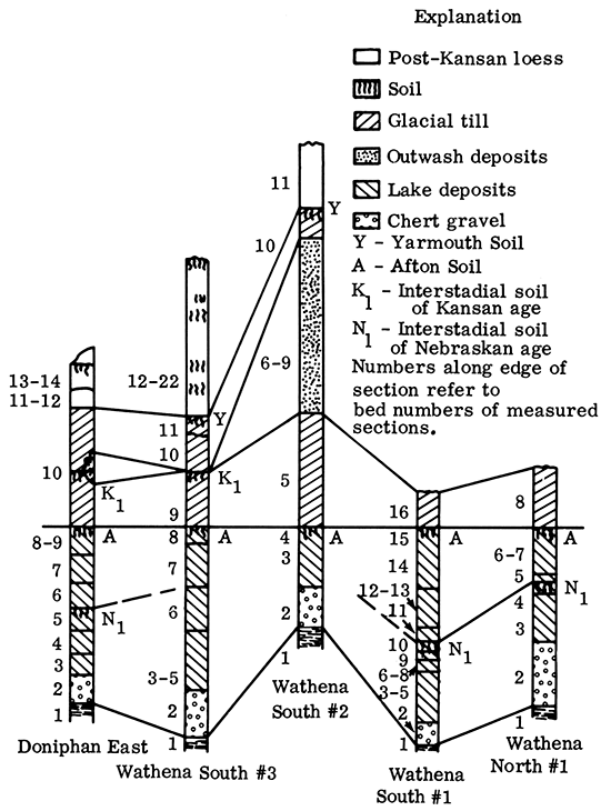
Buried profiles of weathering or fossil soils are probably the most usable criteria for stratigraphic correlation and classification of Pleistocene deposits in Kansas and Missouri. The top of a buried soil is unmistakably an unconformity and where deep welldeveloped soil profiles occur, a significant interval of nondeposition and only slight erosion is indicated. Interpretation of the soils within the Pleistocene sequence involves the evaluation of the soil horizons as interglacial or interstadial and may lead to errors in correlation. The strength of soil development is believed to be the most important factor in this interpretation. Pronounced zones of clay enrichment in the "B" horizon, considerable depth of leaching, great depth of oxidation, and significant thickness of secondary lime accumulation are believed to be better indicators of the interglacial nature of soils than the thickness of the humic "A" horizon which often has been removed by erosion or scour. Stratigraphic position and lithologic character of deposits are important aids in correlation and classification of the Pleistocene.
Kansas Stratigraphic Sections
Wathena North #1 Section
Pleistocene deposits exposed in a small gravel pit 1.3 miles N of Wathena on the Missouri River, or 0.45 mile NE of the SW corner sec. 22, T 3 S, R 22 E, Doniphan County, Kansas.
Discussion
This site exposes deposits considered to be of early Pleistocene age that include the Afton Soil where it has a reddish "B" horizon with a zone of lime accumulation below it indicating good internal drainage with aeration while it was forming. This site contrasts with similar deposits exposed in pits south of Wathena in which the Afton Soil developed under conditions of poor drainage. The Afton Soil is overlain by Kansan till and overlies silty clay deposits in which an interstadial Nebraskan soil is recognized. Fluvial deposits of chert and limestone gravel containing a few northern erratics comprise the lowermost Pleistocene deposits.
Tentative Correlation of Pleistocene Units
Unit 8---Kansan till
Units 5, 6, and 7--Late Nebraskan clays and silts
Units 3 and 4--Early Nebraskan clays and silts
Unit 2--Early Nebraskan gravels
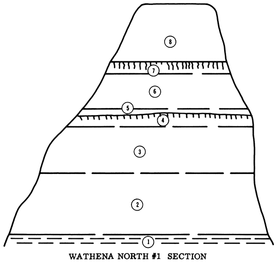
Description of Lithologic Units
| Section measured by James Thorp, C. K. Bayne, and H. G. O'Connor, July 1966 | ||
| Unit number | Description | Thickness, feet |
|---|---|---|
| 8 | Calcareous, oxidized till. Stony clay loam texture containing many erratics but few northern derived erratics. | 10+ |
| 7 | Massive clay, reddish-brown mottled with grayish brown. Contains vertical joints formed by shrinkage. "B" horizon of Afton Soil. | 1.5 |
| 6 | Reddish-brown (moist) to light reddishbrown (dry) fine blocky clay with thin clay skins on blocks. Part of "B" horizon of Afton Soil. Noncalcareous. | 6.3 |
| 5 | Reddish-brown (5 yr 4/4, 5/4) fine blocky silty clay with thin clay skins on blocks. Many decayed lime concretions. Mass calcareous. "C" horizon. | 1.0 |
| 4 | Pink (7.5 yr 7/4, 8/4) silty clay. Noncalcareous except few concretions. "B" horizon of interstadial soil. | 1.8 |
| 3 | Brown (m) to pale brown (d) (10 yr 5.5/3, 6.5/3) weakly stratified silt loam. Very calcareous. "C" horizon of inter- stadial soil. | 8.2 |
| 2 | Chert and limestone gravel with few northern type erratics. | 10.8 |
| 1 | Pennsylvanian shale. | |
Wathena South #1 Section
Pleistocene deposits exposed in a small gravel pit about 0.7 miles SSW of Wathena on the river road or 0.3 mile Sand 0.4 mile W of the NE corner sec. 33, T 3 S, R 22 E, Doniphan County, Kansas.
Discussion
In this exposure about 37 feet of Nebraskan fluvial and lacustrine deposits overlie Pennsylvanian shale and are overlain by Kansan till. The basal deposits are chert and limestone gravel and sand containing a few northern erratics. An accretion-gley (interstadial) soil divides the deposits near the middle of the exposure and a well-developed Afton Soil is developed in the upper silts and clays. The Afton Soil at this site was developed under conditions of poor internal drainage and all or nearly all of the bedding planes have been obliterated by swelling and shrinking of the clays with the formation of slickenside faces. Well-defined clay skins appear on the blocks of the old "B" horizon. Glacial till of Kansan age overlies the Afton Soil.
The Pleistocene deposits below the interstadial soil contain both invertebrate and vertebrate faunas. This is the only known site in Kansas in which deposits considered to be of Nebraskan age include a vertebrate fauna, and are overlain by glacial till. The site has been collected and is being studied but an interpretative report on the vertebrates has not been published. Hopefully, the vertebrate fauna will prove useful in stratigraphic correlation of the glaciated and nonglaciated areas of Kansas.
Tentative Correlation of Pleistocene Units
Unit 16--Nickerson Till (Early Kansan)
Units 11, 12, 13, 14, and 15--Late Nebraskan lacustrine and fluvial deposits
Units 2, 3, 4, 5, 6, 7, 8, 9, and 10--Early Nebraskan lacustrine and fluvial deposits
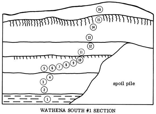
Description of Lithologic Units
| Section measured by James Thorp, H. G. O'Connor, and C. K. Bayne, July 1966 | ||
| Unit number | Description | Thickness, feet |
|---|---|---|
| 16 | Yellowish-brown to reddish-brown calcareous, stony clay till. | 6+ |
| 15 | Silty clay, heavy compact, vertical shrinkage cracks, slickensided joints with clay skins on joint faces. Mass noncalcareous. "B" horizon of Afton Soil. | l.2 |
| 14 | Grayish-brown (m) to light grayishbrown (d) (2.5 yr 5/2, 6/2) silty clay. Noncalcareous, blocky structure, with slickensides and clay skins. Some gray and black mottling. | 5.0 |
| 13 | Light brown (m) to pink (d) (7.5 yr 6/3, 7/3) silty clay with faint mottles. Blocky structure with clay skins on slickenside joints. | 4.0 |
| 12 | Same as above with wider spacing on joints and some gypsum in joints. Contains a few calcium carbonate concretions and has faint stratification but no horizontal cleavage. Mass noncalcareous. | 6.5 |
| 11 | Pinkish-gray (7.5 yr 6/2) silty clay with faint gray and brown mottles. Becomes grayer with depth. Noncalcareous. | 2.3 |
| 10 | Light brownish-gray (m ) to light gray (d) (2.5 yr 6/2, 7/2) compact silty claycontaining fine black specks of decayed vegetation. Noncalcareous except in joints. "A" horizon of an accretion-gley soil. | 1.0 |
| 9 | Very dark grayish-brown (m) to dark grayish-brown (d) (2.5 yr 3/2, 4/2) compact clay containing much humus. Sandy at base. "B" horizon. | 0.8 |
| 8 | Very dark gray (m ) to dark gray (d) (10 yr 3/1, 4/1) massive silty clay with much humus. Noncalcareous except a few etched snail shells. Contains vertebrate remains. "C" horizon. | 0.4 |
| 7 | Gray (10 yr 5/1, 6/1) calcareous, weakly stratified silty clay. | 0.3 |
| 6 | Stratified, calcareous, organic rich silty clay with several fine sand partings. Contains many broken snail shells. "C" horizon. | 2.5 |
| 5 | Bedded fine silty sand. Calcareous. "C" horizon. | 1.7 |
| 4 | Bedded chert and limestone gravel with few northern type erratics. | 1.7 |
| 3 | Sand fine to medium, bedded, strongly calcareous. | 5.2 |
| 2 | Chert and limestone gravel containing a few erratics. | 4.0 |
| 1 | Pennsylvanian shale. | |
Wathena South #2 Section
This site is about 150 yards S of Wathena South #1 Section in the W face of a gravel pit. Located 0.4 mile Sand 0.4 mile W of the NE corner sec. 33, T 3 S, R 22 E, Doniphan County, Kansas.
Discussion
In this exposure the Nebraskan deposits are thinner, and fewer units are recognized than in the nearby Wathena South #1 Section, but the Afton Soil can be recognized in the face of the pit at the north end of the exposure. Above the Afton Soil are two Kansan tills separated by outwash deposits. The lower till is identified as the Nickerson Till (Early Kansan) and the upper till is identified as the Cedar Bluffs Till (Medial Kansan). A partial Yarmouth Soil is developed in the upper till and this is overlain by Loveland loess.
Tentative Correlation of Pleistocene Units
Unit 11--Loveland Formation
Unit 10--Cedar Bluffs Till
Units 6, 7, 8, and 9--Medial Kansan outwash
Unit 5--Nickerson Till
Units 2, 3, and 4--Nebraskan lacustrine and fluvial deposits
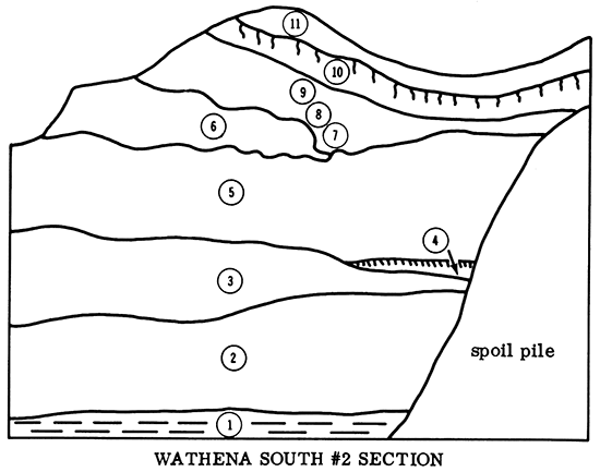
Description of Lithologic Units
| Section measured by C. K. Bayne and H. G. O'Connor, July 1966 | ||
| Unit number | Description | Thickness, feet |
|---|---|---|
| 11 | Silt, buff, noncalcareous. (loess) | 11+ |
| 10 | Silty clay till reddish-brown and buff. Contains caliche nodules in upper part and many northern type erratics. Cedar Bluffs Till. | 5.0 |
| 9 | Sand and gravel with much silt and clay, calcareous. Contains many cobbles and boulders. Granitic types badly decomposed. (outwash) | 13.0 |
| 8 | Dense dark gray till. (transported block) | 2.0 |
| 7 | Same as bed 9. | 2.0 |
| 6 | Sand and gravel like bed 3 with inclusions of dark gray till and a large block of fine to very fine sand similar to Atchison Formation type sand. | 13.0 |
| 5 | Gray to dark gray clay till, very compact and hard, containing cobbles and boulders almost entirely of local origin. Nickerson Till. | 19.0 |
| 4 | Massive vertically jointed noncalcareous clay with slickensides poorly exposed in north end of pit. Afton Soil. | 0-4 |
| 3 | Bedded well-graded silt and sand and tannish-gray clay beds. Noncalcareous. | 10 |
| 2 | Chert and limestone gravel and sand containing a few northern type erratics. (A bone from an early Pleistocene deer-like animal was taken 1.5 feet below the top of this bed.) | 7.0 |
| 1 | Pennsylvanian shale. | |
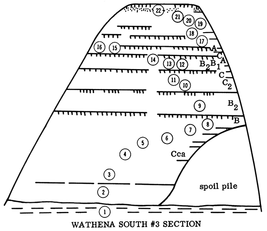
Wathena South #3 Section
Borrow area for earth-fill dam on a small stream. About 1,500 feet ESE of eenter of W line see. 33, T 3 S, R 22 E, Doniphan County, Kansas. Loeated about 200 feet W of river road, on SW facing exposure.
Discussion
In this section three incipient soils in Wisconsinan loesses occur below the modern soil. A well-developed Sangamon Soil is present lying on a truncated Yarmouth Soil. A truncated interstadial soil (Kansan) may be represented in bed 9, the lower of two Kansan tills. The paleosol developed in the lake clays beginning with bed 8 represents a long period of soil formation under wet eonditions and poor internal drainage and is identified as the Afton Soil. The "A" horizon of the Afton Soil has been stripped off by the overriding glaeier. Early Nebraskan water-laid gravels are the basal Pleistoeene deposits.
Tentative Correlation of Pleistocene Units
Units 20, 21, and 22--Bignell Formation
Units 17, 18, and 19--Peoria Formation(?) or Bignell Formation (?)
Units 15 and 16--Gilman Canyon Formation
Units 12, 13, and 14--Loveland Formation
Units 10 and 11--Cedar Bluffs Till
Unit 9--Nickerson Till
Units 2, 3, 4, 5, 6, 7, and 8--Nebraskan lacustrine and fluvial deposits
Description of Lithologic Units
| Section measured by James Thorp and C. K. Bayne, July 1966 | ||
| Unit number | Description | Thickness, feet |
|---|---|---|
| 22 | Grayish-brown (m) to light gray (d) (10 yr 4/2, 6/2) friable silt. Partly eroded "A" horizon of modern soil. | 0.6 |
| 21 | Brown (m) to very pale brown (d) (10 yr 5/3, 7/3) friable noncalcareous silt. "Color-B" horizon contains no illuvial clay. | 3.0 |
| 20 | Finely mottled (10 yr 6/3, 8/3) and (7/1, 9/1) friable silt, calcareous with thin bands of "loess puppets." | 5.0 |
| 19 | Pale brown (m) to very pale brown (d) (10 yr 6/3, 7/3) friable noncalcareous silt. Calcareous on faces of joints. | 2.0 |
| 18 | Mottled very pale brown, pale yellow and black friable calcareous silt. | 2.0 |
| 17 | Light yellowish-brown (m ) to very pale brown (d) (10 yr 6/4, 7/4) structureless silt. Lower 1 foot calcareous. | 4.5 |
| 16 | Brown (m) to very pale brown (d) (10 yr 5/3, 7/3) noncalcareous friable silt. "A" horizon of Gilman Canyon Soil. | 1.1 |
| 15 | Same color as above but calcareous. "C" horizon of above soil. | 2.1 |
| 14 | Grayish-brown (m) to light gray (d) (10 yr 5/2, 7/2) noncalcareous platy friable silt. "A" horizon of well developed Sangarnon Soil. | 1.8 |
| 13 | Grayish-brown (m) to light brownish-gray (d) (10 yr 5/2, 6/2) subangular blocky silty clay. Thin clay skins on blocks. Noncalcareous. "B1" horizon. | 2.0 |
| 12 | Yellowish-brown (m) to very pale brown (d) (10 yr 5/4, 7/4) subangular, blocky, clayey silt. Some clay skins. Mass noncalcareous. "B2" horizon developed in loess. | 2.0 |
| 11 | Brownish-yellow (m) to yellow (d) (10 yr 6/5, 7/5) finely blocky clay till, noncalcareous except for a few lime concretions. Mottled with gray and black spots. "C1" horizon of truncated Yarmouth Soil. Contains inclusions of black clay from lake clays below. | 2.8 |
| 10 | Oxidized and strongly weathered calcareous till with many large lime concretions. Contains rounded inclusions of brownish-yellow sand. "C2" horizon. | 6.6 |
| 9 | Light olive-brown (m) to pale yellow (d) (2.5 yr 5/3, 7/3) massive to coarsely blocky calcareous till. Contains much limestone and few northern erratics. Contains a few lime concretions in upper part. Part of a paleosoil from which "A" and "B" horizons have been removed by overriding ice. | 9.0 |
| 8 | Brownish-yellow (m) to yellow (d) (10 yr 5.5/6, 6/5.6) light mottled clay. Noncalcareous with slickensided joints. Upper part of "B" horizon of lake clay soil (Afton). | 3.2 |
| 7 | Gray (m) to light gray (d) (2.5 yr 5.5/1, 7.5/1) coarse blocky clay with clay skins on blocks. Some pinkish-gray mottles. | 3.0 |
| 6 | Grayish-brown (m) to light gray (d) sharply blocky clay with clay skins on blocks. | 2.6 |
| 5 | Light gray (m) to white (d) blocky clay with mottles of light brown. | 1.5 |
| 4 | Same as bed 5, carbonate in plates and irregular masses in joints. "Cca" horizon. | 7.3 |
| 3 | Light brownish-gray (m) to white (d) laminated silty clay. | 10.1 |
| 2 | Brown water-laid chert gravel. | 8.2 |
| 1 | Pennsylvanian shale. | |
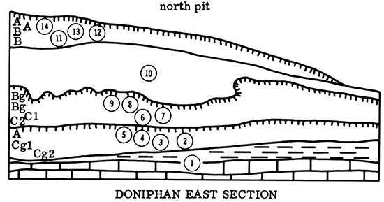
Doniphan East Section
Pleistocene deposits exposed about 90 feet above the Missouri River floodplain in an Oread Limestone quarry in the river bluff. Located 250 feet Sand 1,900 feet W of the NE corner sec. 9, T 5 S, R 21 E, Doniphan County, Kansas.
Discussion
This section exposes a Sangamon paleosol developed in Loveland loess and some underlying "lag" material that is partly water laid. At the north end of the pit where this section was measured, the next lower material is calcareous oxidized boulder clay till that is identified as Nickerson Till.
At the south end of this exposure the Nickerson Till has a weak interstadial soil developed at the top and is overlain by a wedge of outwash sand and gravel and a younger till (Cedar Bluffs). Below the Nickerson Till are about 31 feet of lacustrine and fluvial deposits containing the Afton Soil in the upper part and an interstadial soil near the middle. The two paleosols beneath the till have little or no true soil structure. The clays break with a starchy fracture, and have developed many intersecting slickenside faces in the past with periodic changes in moisture content. The clays shrink markedly with drying. The silty clay material below the Nickerson Till might be interpreted as gumbo til by some workers, but visual evidence of horizontal bedding would indicate the material is lacustrine.
Tentative Correlation of Pleistocene Units
Units 11, 12, 13, and 14--Loveland Formation and Illinoisan gravels
Unit 10--Nickerson Till
Units 6, 7, 8, and 9--Late Nebraskan lacustrine and fluvial deposits
Units 2, 3, 4, and 5--Early Nebraskan lacustrine and fluvial deposits
Description of Lithologic Units
| Section measured by James Thorp and H. G. O'Connor, August 1966 (north end north pit) | ||
| Unit number | Description | Thickness, feet |
|---|---|---|
| 14 | Brown (m) to very pale brown (d) (10 yr 5/3, 7/3) silt. Friable when moist, noncalcareous Loveland Loess. "A" horizon of Sangamon Soil. | 1.4 |
| 13 | Yellowish-brown (m) to pale brown (d) (10 yr 5/4, 7/4) massive silt. Friable when moist. Noncalcareous Loveland Loess. "A" horizon. | 2.8 |
| 12 | Yellowish-brown (m) to very pale brown (d) (10 yr 5/4, 7/4) blocky clay containing some sand and gravel. Noncalcareous mass with discontinuous clay skins on blocks. "B1" horizon of Sangamon Soil developed in partly water-worked material. | 1.0 |
| 11 | Brownish-yellow (m) to very pale brown (d) (10 yr 5/5, 7/5) blocky clay with some white and brown mottles. Thin clay skins. "B" horizon. | 2.0 |
| 10 | Strongly calcareous oxidized boulder clay till containing many secondary lime concretions in upper part and many northern erratics. | 20-25 |
| 9 | Grayish-brown (m) to light gray (d) (10 yr 5/2, 7/2) silty clay. Plastic when wet and very hard with vertical joints when dry. "Bg" horizon of Afton Soil. Original structure destroyed and few clay skins on surface of blocks. Scattered pebbles. | 2.4 |
| 8 | Gray (m) to light gray (d) (7.5 yr 5/1, 6/1) silty clay with coarsely blocky structure and slickenside structure in moist conditions. "Bg' horizon. | 3.0 |
| 7 | Brown (m) to pinkish-gray (d) silty clay. Shatters to fine blocks when dry but same structure as bed 8 when moist. No clay skins. "C1" horizon. | 4.5 |
| 6 | Brown (m) to very pale brown (d) (10 yr 5/3, 7/3) silty clay with a few lighter streaks. Some evidence of bedding but same fracture as above. Base of upper soil in lake sediments. "C2" horizon. | 4.5 |
| 5 | Very dark brown (m) to brown (d) (7.5 yr 3/2, 5/2) massive silty clay. "A1" horizon of a buried low-humic gley soil developed in a permanently wet site. | 4.0 |
| 4 | Same as above bed except color is dark brown (m) to brown (d) and contains scattered chert and quartz pebbles. Transition zone. | 4.0 |
| 3 | Similar to bed 4 except color is brown (m) to pale brown (d) (10 yr 5/3, 6/3). "Cg1" horizon. | 3.5 |
| 2 | Gray (m) to light gray (d) sandy clay horizontal bedding with manganese streaks. Contains as much as 6 inches of chert gravel in lower part. "Cg2" horizon. | 5.0 |
| 1 | Pennsylvanian limestone and shale. | |
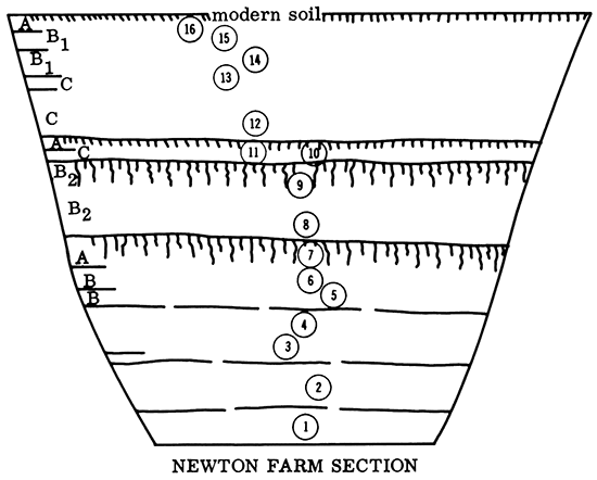
Newton Farm Section
Pleistocene deposits exposed along an E trending gully S of driveway into the Newton farm, SE SE NW sec. 12, T 3 S, R 21 E, Doniphan County, Kansas.
Discussion
The Newton Farm site exposes two well-defined soils, the upper of which is capped by a thin laminated silt with a humic soil a few inches thick at its top. The lowermost soil, developed in silty material overlying leached Kansan till over calcareous Kansan till is interpreted as a Yarmouth Soil (bed 7) because there is an erosion pavement of pebbles and boulders between the leached till and the silty clay part of the profile. This erosion pavement could have formed after the deposition of the later of two Kansan tills. The erosion pavement and the till immediately below contain much Sioux Quartzite and other igneous and metamorphic rocks. In contrast the till in contact with the clay at the Wathena South sites has mostly local rocks and relatively few erratics.
The oldest paleosol at the Newton Farm site is best classed as a low-humic gley. It is silty but contains much clay and some sand, especially in the lower part. The material was laid in a low place and probably was laid partly by water and partly by wind. That it was not completely saturated, though, is attested by the presence of burrow-fills (crotowinas) in its "B" horizon. The paleosol is judged to be of Yarmouthian age. The next older paleosol (bed 9) is in silty clay material and is much like the oldest one. It is judged to be of Sangamon age.
The laminated gray silt (bed 10) with dark humic layer above it (bed 11) was judged by E. C. Reed to represent the Gilman Canyon Formation (with soil) of Wisconsinan age, corresponding to Farmdale of Illinois. Carbon-14 analysis of this soil in Nebraska gives dates of 25,000-28,000 years BP.
One of the interesting things seen at this site is the redder buried soils of the same age which lie up the valley from the original site described. In this area the "B" horizon of the Sangamon Soil is quite red except for grayish mottles that have developed under the influence of percolating water since the paleosol was mantled by Peoria loess. This is an excellent site to illustrate paleo-soil catenas.
Tentative Correlation of Pleistocene Units
Units 12, 13, 14, 15, and 16--Peoria Formation
Units 10 and 11--Gilman Canyon Formation
Units 8 and 9--Loveland Formation
Units 3, 4, 5, 6, and 7--Late Kansan loess and fluvial deposits
Units 1 and 2--Kansan till (Cedar Bluff Till?)
Description of Lithologic Units
| Section measured by James Thorp, H. C. O'Connor, and C. K. Bayne, August 1966 | ||
| Unit number | Description | Thickness, feet |
|---|---|---|
| 16 | Dark grayish-brown (m) to light grayish-brown (d) (10 yr 4/2, 6/2) friable silt with fine crumbly structure. "A" horizon of modern soil. | 0.8 |
| 15 | Brown (m) to pale brown (d) friable silt. "B1" horizon modern soil. | 2.0 |
| 14 | Same color as above, blocky silty clay with thin clay skins and a few dark brown mottles. "B1" horizon. | 2.0 |
| 13 | Transition to "C" horizon. Black and yellow silt mottled brown. | 0.8 |
| 12 | Light gray (m) to nearly white (d) (10 yr 6.5/1, 8/1) friable structureless silt, coarsely mottled brown to reddish-yellow (7.5 yr 5/8, 6/8). "C" horizon. | 4.2 |
| 11 | "A1" horizon of a humic-gley soil (Gilman Canyon) dark gray (m) to gray (d) (10 yr 4/1. 6/1). Fine blocky silty clay with clay skins on some blocks. | 1.3 |
| 10 | Light gray (m) to white (d) friable laminated silt, noncalcareous, "C2" horizon of above soil. Depositional break with bed below. | 0.8 |
| 9 | Light brownish-gray (m) to very light gray (d) (10 yr 6/1.5, 8/1.5) weakly blocky silty clay with very thin clay skins and dark brown mottles. "B21" horizon of Sangamon Soil. | 1.5 |
| 8 | Coarsely mottled gray (m) to nearly white (d) and reddish-brown (m) to light brown (d) blocky heavy silty clay with some clay skins on blocks. "B22" horizon of Sangamon Soil. | 5.0 |
| 7 | Grayish-brown (m) to light grayishbrown (d) (10 yr 5/l.5, 6/l.5) nearly massive heavy silty clay. "A" horizon Yarmouth Soil. Contains a few lime concretions in a noncalcareous mass. | 2.5 |
| 6 | Brown (m) to very pale brown (d) (10 yr 5/3, 7/3) mottled strongly brown (7.5 yr 5/6) silty clay, weakly blocky, noncalcareous mass but contains many lime concretions. | 1.5 |
| 5 | Colors as above. Weakly blocky silt loam containing a few black manganese spots. | 1.3 |
| 4 | Light brownish-gray (m) to very light gray (d) friable silt mottled with black manganese (loess). | 4.8 |
| 3 | Noncalcareous bedded fine sand with manganese spots. Erosion pavement of pebbles and boulders. | 0.5 |
| 2 | Leached and oxidized clay till with enfolded sand and gravel. | 3.8 |
| 1 | Black (m) to light gray (d) (2.5 yr 3/0.5, 6/0.5) strongly calcareous till with many kinds of erratics. | 3.0 |
Missouri Stratigraphic Sections
Wyeth Park Section
Pleistocene deposits (Wyeth Park locality) above MacArthur Drive, N of the foot of Jule Street in St. Joseph, Missouri, east-central part of sec. 7, T 57 N., R 35 W.
Discussion
The Wyeth Park locality is important to students of the Pleistocene in Missouri because of the exceptional thickness of the Pleistocene succession that is exposed and the large number of depositional and paleosol units that are represented. Many of the interrelated factors involved in the interpretation of such a succession are illustrated at this stop. One of these is the importance of information about the topography prior to deposition of the various units. An early Pleistocene valley is assumed to have occupied a position within the area of the modern Missouri River valley at this point, and probably represented part of an upstream segment of a prominent east-trending buried valley (St. Joseph Valley of Heim and Howe, 1963a) extending to the east from the southern part of St. Joseph. Basal silt seen at this locality may represent ponded sediment deposited during a period of drainage blockage during Nebraskan or Kansan time. The silt closely resembles Nebraskan silt present at approximately the same elevation at a point almost directly across the Missouri River in Doniphan County, Kansas. The overlying sand probably represents a remnant of Illinoian terrace deposits that occur along an essentially modern course of Missouri River above Kansas City. The loess sequence and associated paleosol above the Illinoian (?) terrace material were deposited or developed upon increasingly precipitous bluffs at the edge of the Missouri River valley. The lateral variations along the bluff are typical. Among the interesting features is the evidence of slump and landslide structures, part of which developed prior to Late Wisconsinan time.
The unit tentatively referred to the Roxana is the only depositional record of the relatively long period following the development of the Sangamon Soil and preceding the beginning of Peoria Loess deposition. It is probably correlative with the Wisconsinan Roxana sequence (Frye and Willman, 1960) of western Illinois (see regional discussion).
In addition to the ancient colluvial deposits, loess mixed with modern rubble can be seen at various localities in the southern part of the exposure. Holes have been drilled to bedrock 1,200 feet southeast of the Wyeth Park section. The silt exposed in the base of the cliff is probably underlain by alluvial sand and gravel. Till was not encountered in the drill holes.
Tentative Correlation of Pleistocene Units
Units 14 and 15--Bignell Loess
Units 8, 9, 10, 11, 12, and 13--Peoria Loess
Units 6 and 7--Roxana? Loess
Units 4 and 5--IIlinoian sand
Units 1, 2, and 3--Nebraskan or Kansan silt
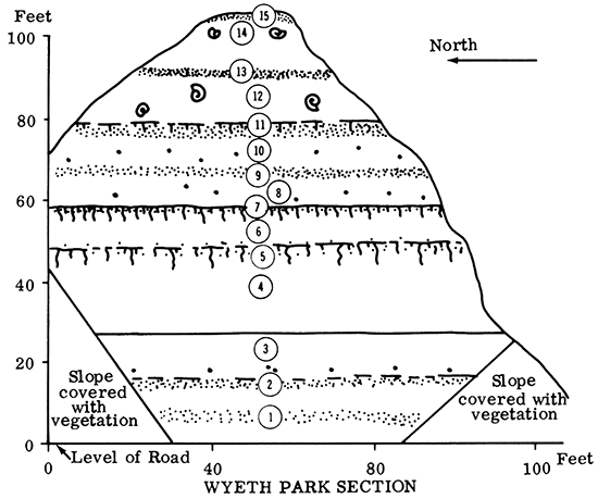
Description of Lithologic Units
| Section measured by S. N. Davis, 1970 | ||
| Unit number | Description | Thickness, feet |
|---|---|---|
| 15 | Silt, grading from dark yellowish-brown at top to pale yellowish-brown at bottom. Eroded modern "A" and "B" horizons. | 1.0 |
| 14 | Silt, pale yellowish-brown. Calcareous, some gastropod remains. Very porous and not as compact as units below. | 13.0 |
| 13 | Silt, pale yellowish-brown, but slightly darker than units above and below. Slightly calcareous. | 1.5 |
| 12 | Silt, pale yellowish-brown. Calcareous, some gastropod remains. | ll.5 |
| 11 | Silt, pale yellowish-brown but darker than units above or below. Not calcareous. | 3.0 |
| 10 | Silt, moderate yellowish-brown. Calcium carbonate concretions. Silt matrix not calcareous. Strongly developed vertical jointing. | 9.0 |
| 9 | Silt, moderate yellowish-brown. Slightly darker zone than above or below. | 1.0 |
| 8 | Silt, moderate yellowish-brown. Calcium carbonate concretions. Silt matrix not calcareous. Strongly developed vertical jointing. | 8.0 |
| 7 | Silt, some clay, moderate yellowishbrown. Not calcareous. Closely spaced cracks give fine, blocky appearance. | 2.5 |
| 6 | Silt, few sand grains, moderate yellowish-brown. Not calcareous. | 7.5 |
| 5 | Silt, sandy, some clay, moderate brown. Not calcareous but with relict concretions. | 5.0 |
| 4 | Sand, fine to medium, pale yellowish-brown. | 20.0 |
| 3 | Silt, some clay, yellowish-brown. Few large (maximum diameter 6 inches) calcium carbonate concretions near base. | 9.0 |
| 2 | Silt, clayey, yellowish-brown, slightly darker than units above or below. Not calcareous. | 2.0 |
| 1 | Silt, some clay, yellowish-brown. Not calcareous. Slightly darker band in about middle of this unit. | 12.0 |
East Hyde Park Section
Loess exposure at East Hyde Park near the intersection of Hyde Park and King Hill roads in the southern part of St. Joseph, Missouri, east-central part of sec. 31, T. 57 N., R. 35 W.
Discussion
The East Hyde Park section is similar to the Wyeth Park section except the buried soils at Hyde Park are not as prominent. Only the lower soil (Sangamon?) is clearly exposed. Other zones of incipient soil development are, however, suggested by the degrees of leaching and scarcity of fossil gastropods at various horizons. An interesting "fault" is exposed in the eastern part of the roadcut. Great care must always be exercised in working with Pleistocene deposits along the bluffs of the Missouri River. Almost all large exposures show some evidence of ancient mass movements.
The difficulties encountered in trying to identify the Bignell Loess are well illustrated at the Hyde Park section. A well-defined Brady soil is only rarely found along the Missouri River. Most commonly the Bignell Loess can be recognized by (1) non-compact, porous texture, (2) lack of a deeply weathered modern soil at the surface, (3) abundant content of fossils, and (4) high carbonate content. A few hundred yards from the bluff line the loess is leached of most carbonates and the Bignell Loess cannot be distinguished from the underlying Peoria Loess.
Tentative Correlation of Pleistocene Units
Unit 9--Bignell Loess Units 6, 7, and 8--Peoria Loess Unit 5--Roxana? Formation Units 3 and 4--Loveland Formation. Unit 4 is a well-developed Sangamon Soil. Unit 2--IlIinoian colluvium
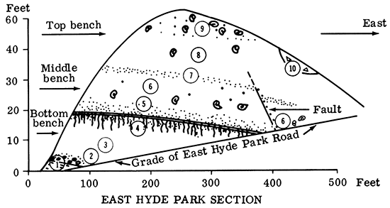
Description of Lithologic Units
| Section measured by S. N. Davis, 1970 | ||
| Unit number | Description | Thickness, feet |
|---|---|---|
| 10 | Silt and rubble. Modern gully filling. | 2.0 |
| 9 | Silt, porous, calcareous, with fossil gastropods and scattered concretions, moderate yellowish-gray. Upper part of this unit has been removed artificially. | 6.0 |
| 8 | Silt, compact, very few fossil gastropods, moderate yellowish-gray, calcareous. | 11.0 |
| 7 | Silt, compact, no fossils, small zones of manganese staining, moderate yellowish-brown, only slightly calcareous. | 2.0 |
| 6 | Silt, abundant fossil gastropods at base, scattered calcareous concretions, moderate to pale yellowish-brown | 9.0 |
| 5 | Silt, some clay near base, suggestion of incipient soil at top of unit, moderate yellowish-brown, not calcareous. | 4.5 |
| 4 | Silt, considerable clay, few grains of sand, light brown. | 5.0 |
| 3 | Silt, some grains of sand, compact, moderate yellowish-brown, not calcareous. | 16.0 |
| 2 | Silt mixed with limonite, chert, and limestone fragments. | 2.0 |
| 1 | Shale (Pennsylvanian) | 1.0 |
Iatan Section
Loess and bedrock at Iatan, Missouri (Platte County), near center of sec. 9, T 54 N, R 36 W.
Discussion
The Iatan exposure is the east face of an old borrow pit which was developed about 40 years ago. The stability of the loess cliff is indicated by the fact that scars of the original power-shovel operation can still be seen in parts of the face. A rich fauna of fossil gastropods from several different horizons has been collected from this site. All the fossils are late Wisconsinan and do not suggest significant ecological changes during the periods of loess deposition.
The type locality for the Iatan limestone is along the railroad cut just west of the exposure of loess. The Iatan Formation is in the uppermost part of the Missourian Series, Pennsylvanian System.
Tentative Correlation of Pleistocene Units
Units 11 and 12--Bignell Loess
Units 7, 8, 9, and 10--Peoria Loess. Unit 10 may be a poorly developed Brady soil.
Unit 6--Roxana? Formation
Units 4 and 5--Loveland Formation. Unit 4 may be a truncated Sangamon Soil.
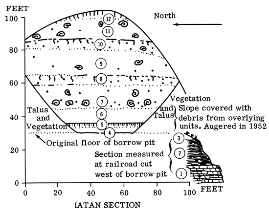
Description of Lithologic Units
| Section measured by S. N. Davis, 1954 | ||
| Unit number | Description | Thickness, feet |
|---|---|---|
| 12 | Silt, yellowish-gray, slightly blocky structure but well-defined soil horizons not present, leached of calcium carbonate. | 5 |
| 11 | Silt, yellowish-gray, poorly compacted, calcareous, abundant gastropod shells, few small calcareous concretions. | 12 |
| 10 | Silt, yellowish-gray, slight amount of clay, many calcareous concretions, maximum diameter 40 mm, matrix of loess is leached except along joint surfaces and in lowest part of unit, a few gastropod fragments can be found. | 6 |
| 9 | Silt, yellowish-brown, fewer concretions than unit 10, matrix of loess is slightly calcareous, scattered fragments of gastropods. | 16 |
| 8 | Silt, yellowish-brown, more clay than units 7 or 9, partly leached matrix, calcareous concretions up to 100 mm diameter, no gastropod remains. | 6 |
| 7 | Silt, yellowish-brown, few calcareous concretions, maximum diameter 60 mm, abundant fossil gastropods. | 14 |
| 6 | Silt, coarse, sandy in basal part, yellowish-brown, leached of calcium carbonate. | 9 |
| 5 | Silt, sandy, and clayey, moderate yellowish-brown, leached of calcium carbonate. | 2 |
| 4 | Sand, silty, yellowish-brown, leached of calcium carbonate, bottom of this unit not penetrated completely by auger. | 4+ |
| 3 | Not exposed and not penetrated by auger. | 5 |
| 2 | Shale (Pennsylvanian, Douglas Group). | 15 |
| 1 | Limestone (Pennsylvanian, Pedee Group, Iatan Formation) bottom not exposed. | 10 |
Kansas City International Airport Section
Ferrelview Formation at the entrance to the Kansas City International Airport and adjacent to Highway 1-29, near center of S line, NW NE sec. 26, T. 52 N., R. 34 W., Platte County, Missouri.
Discussion
The Ferrelview Formation, a post-Kansan(?) silty clay, has been exposed in numerous excavations for airports and highways during the past 20 years. Unfortunately, a given exposure does not remain in good condition for more than two or three years. The descriptions given here, nevertheless, are typical of the deposits underlying the broad upland areas north of the Missouri River in Platte and Clay counties, Missouri.
The Ferrelview Formation is of interest for at least two reasons. First, the formation is composed of material which has been called "gumbotil." The petrology and thickness of the deposit as well as a stone line separating the Kansan till from the "gumbotil," however, argue against the interpretation that the "gumbotil" is the result of normal weathering of till. Second, the clay and silt of the Ferrelview Formation may represent an accretion-gley deposit composed of increments from Kansan till, Kansan loess, and minor amounts of other material.
Drill holes in this vicinity generally show the following succession (after Howe and Heim, 1968):
| Range of thickness, feet |
||||
|---|---|---|---|---|
| Wisconsinan Stage | ||||
| Peoria Loess (some Roxana? and Bignell included) | ||||
| 1. | Modern "A-B" horizon 1 to 3 | |||
| 2. | Loess | 5 to 10 | ||
| Illinoian Stage | ||||
| Loveland Loess | ||||
| 3. | Silt, clayey, "B" horizon Sangamon soil | 4 to 7 | ||
| 4. | Silt, clayey | 5 to 15 | ||
| Yarmouthian Stage (?) | ||||
| Ferrelview Formation | ||||
| 5. | Clayey silt | 5 to 20 | ||
| Kansan Stage | ||||
| Kansan till | ||||
| 6. | Sandy clay | 10 to 40 | ||
| Pre-Pleistocene Bedrock | ||||
| 7. | Limestone and/or shale, up to 1 foot weathered material on top of rock | |||
Tentative Correlation of Pleistocene Units
Units 6 and 7--Bignell and Peoria Loess
Unit 5--Roxana? Loess
Units 3 and 4--Loveland Formation
Units 1 and 2--Ferrelview Formation
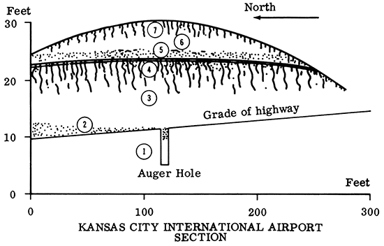
Description of Lithologic Units
| Section measured by S. N. Davis, 1970 | ||
| Unit number | Description | Thickness, feet |
|---|---|---|
| 7 | Silt, grading from dark yellowish-brown at top to moderate yellowish-brown at bottom. Not calcareous. Modern "A" and "B" horizons. | 2.5 |
| 6 | Silt, moderate yellowish-brown. Not calcareous. | 2.0 |
| 5 | Silt, mottled moderate yellowish-brown, and some dark yellowish-brown, Not calcareous. | l.5 |
| 4 | Silt, clayey, light brown. Not calcareous. | 4.0 |
| 3 | Silt, some clay, moderate yellowish-brown. Not calcareous. | 7.0 |
| 2 | Silt, clayey, mottled pale yellowish-brown and moderate yellowish-brown. Not calcareous. | 3.0 |
| 1 | Clay, silty, pale yellowish-brown. Not calcareous. Very few widely scattered siliceous pebbles. | 5.0 |
Lower 6.0 feet of this section augered. Lower two units are also exposed in a grader ditch 200 feet north of measured section.
Randolph Section
Discussion
Exposures of loess near Randolph are some of the most complete and extensive in the State of Missouri. Unfortunately, the loess is leached of most carbonates and the recognition of zones of partially weathered loess is difficult. A few calcium carbonate concretions are present, but fossil gastropods have not, as yet, been found. The most distinctive feature of the exposures is the large number of buried "soils" which can be seen. Most of the "soils" appear as dark bands in the outcrop. The dark color is, in part, caused by closely spaced shrinkage cracks which in turn are related to the clay content that is greater than adjacent, less weathered loess.
The Missouri State Highway Department has drilled several test holes in the vicinity of the road cuts at Randolph. Most holes encountered 10 to 25 feet of weathered till underlying the glacial (?) sands and gravels and resting directly on Pennsylvanian bedrock.
Tentative Correlation of Pleistocene Units
Units 15 and 16--Bignell Loess
Units 9, 10, 11, 12, 13, and 14--Peoria Loess. Unit 14 may be a poorly defined Brady Soil.
Units 7 and 8--Roxana? Formation
Units 5 and 6--Loveland Formation. Unit 6 is a well-developed Sangamon Soil.
Units 2, 3, and 4--Late Kansan sand and silt
Unit 1--Medial Kansan silt
Medial Kansan till--Sand and gravel not exposed, but penetrated in drill holes.
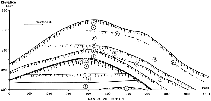
Description of Lithologic Units
| Section measured by S. N. Davis, 1970 | ||
| Unit number | Description | Thickness, feet |
|---|---|---|
| 16 | Silt, dark yellowish-brown at top to moderate yellowish-brown at bottom. Not calcareous. "A" and "B" horizons of modern soil. | 2.5 |
| 15 | Silt, pale yellowish-brown, not calcareous. | 5 |
| 14 | Silt, pale yellowish-brown, not calcareous. Slightly darker and contains more clay than units above or below. | 1 |
| 13 | Silt, pale yellowish-brown, not calcareous. | 14 |
| 12 | Silt, moderate yellowish-brown, not calcareous. More clay coatings on silt grains than found above or below this unit. | 2.5 |
| 11 | Silt, pale yellowish-brown, not calcareous. | 2.5 |
| 10 | Silt, moderate yellowish-brown, not calcareous. More clay coatings than in units above or below. | 1.5 |
| 9 | Silt, pale yellowish-brown, not calcareous. | 25 |
| 8 | Silt, moderate yellowish-brown, not calcareous, more clay than in units above or below. | 3.5 |
| 7 | Silt, pale yellowish-brown at top grading to pale brown (7.5 yr 5/4, dry) at bottom. not calcareous. Relic casts of former concretions. | 14 |
| 6 | Silt, clayey, moderate brown, not calcareous. | 5 |
| 5 | Silt, few sand grains, moderate yellowish-brown, not calcareous. | 11 |
| 4 | Sand, medium grain size, some silt and clay, moderate yellowish-orange, not calcareous. | 2.5 |
| 3 | Sand, fine grain size, considerable silt, scattered pebbles at base of this unit, not calcareous. | 5 |
| 2 | Silt, some fine sand, horizontal bedding few millimeters thick is prominent in central part of unit, yellowish-gray, calcareous concretions but matrix has little or no reaction to acid. | 7 |
| 1 | Silt, some clay, dark yellowish-orange mottled with some gray near base of exposure. Small manganese-rich concretions scattered in upper part. | 5 |
The Missouri State Highway Department has drilled 10 test holes to bedrock in the interchange area of the highway. All except two of the holes penetrated from 10 to 25 feet of weathered to unleached till before entering bedrock. The hole nearest the measured section penetrated 20.8 feet of till starting about 20 feet below road level.
References
Bayne, C. K., 1968, Evidence of multiple stades in the lower Pleistocene of northeastern Kansas: Trans. Kansas Acad. Sci., v. 71, no. 3, p. 340-349.
Bayne, C. K., and O'Connor, H. G., 1967, Two tills of Kansan age in northeastern Kansas; in, Geological Survey Research--Regional Geology: U.S. Geol. Survey, Prof. Paper 575, p. A77.
Bayne, C. K., and O'Connor, H. G., 1968, Quaternary System; in, The Stratigraphic Succession in Kansas, Zeller, D. E., Ed.: Kansas Geol. Survey Bull. 189, p. 59-67. [available online]
Davis, S. N., 1955, Pleistocene geology of Platte County, Missouri: Unpub. Ph.D. dissertation, Yale Univ., New Haven, Connecticut.
Dort, Wakefield, Jr., 1966, Nebraskan and Kansan stades; complexity and importance: Science, v. 154, no. 3750, p. 771-772.
Dreeszen, V. H., 1970, The stratigraphic framework of Pleistocene glacial and periglacial deposits in the Central Plains; in, Pleistocene and Recent Environments of the Central Great Plains: Univ. Kansas Dept. Geology Spec. Pub. 3, Univ. Press of Kansas, p. 9-22.
Frye, J. C., and Leonard, A. B., 1949, Pleistocene stratigraphic sequence in northeastern Kansas: Am. Jour. Sci., v. 247, p. 883-899.
Frye, J. C., and Leonard, A. B., 1952, Pleistocene geology of Kansas: Kansas Geol. Survey Bull. 99, 230 p. [available online]
Frye, J. C., and Willman, H. B., 1960, Classification of the Wisconsinan Stage in the Lake Michigan Glacial Lobe: Illinois State Geol. Survey Circ. 285, 16 p.
Frye, J. C., Willman, H. B., and Glass, H. D., 1968, Correlation of Midwestern loesses with the glacial succession; in, Loess and Related Eolian Deposits of the World: Congo Int. Assoc. for Quat. Research (INQUA), Proc. VII, V. 12, p. 3-21.
Glass, H. D., Frye, J. C., and Willman, H. B., 1968, Clay mineral composition, a source indicator of Midwest loess; in, The Quaternary of Illinois: Ill. Univ. College of Agriculture Spec. Pub. 14, p. 35-40.
Heim, G. E., and Howe, W. B., 1963a, Pleistocene drainage and depositional history in northwestern Missouri: Trans. Kansas Acad. Sci., v. 66, no. 3, p. 378-392.
Heim, G. E., and Howe, W. B., 1963b, Map of the bedrock topography of northwestern Missouri: Missouri Geol. Survey and Water Resources, one sheet.
Howe, W. B., 1968, Guidebook to Pleistocene and Pennsylvanian formations in the St. Joseph area, Missouri: Association Missouri Geologists, 15th Annual Field Trip, 45 p.
Howe, W. B., and Heim, G. E., 1968, The Ferrelview Formation (Pleistocene) of Missouri: Missouri Geol. Survey and Water Resources, Rept. Inv. 42, 32 p.
Martin, J. A., and Williams, J. H., 1966, Stratigraphic section; in, The Grundel Mastodon by M. G. Mehl: Missouri Geol. Survey and Water Resources, Rept. Inv. 35, p. 26-28.
Reed, E. C., and Dreeszen, V. H., 1965, Revision of the classification of the Pleistocene deposits of Nebraska: Nebraska Geol. Survey Bull. 23, 65 p.
Ruhe, R. V., Rubin, Meyer, and Scholtes, W. H., 1957, Late Pleistocene radiocarbon chronology in Iowa: Am. Jour. Sci., v. 255, p. 571-689.
Wright, H. E., and Ruhe, R. V., 1965, Glaciation of Minnesota and Iowa; in, Geology of the Quaternary of the United States-A review volume for the VII Congress of INQUA, Part I: Princeton Univ. Press, p. 29-41.
Previous--Regional Pleistocene Stratigraphy || Next--Buried Valleys