Kansas Geological Survey, Map 45, originally published in 1996
Originally published in 1996 as Kansas Geological Survey Map 45. This is, in general, the original text as published. The information has not been updated. An Acrobat PDF version (313 MB) is also available.
The Midcontinent Rift System is a 1,500-km (900-mi) long Middle Proterozoic aborted rift extending from the Lake Superior region southwestward into Kansas (Sims, 1990). The rift can be divided into three distinct segments (Dickas and Mudrey, 1989) separated from each other by accommodation structures. The southernmost Kansas segment of the rift is separated from the Nebraska and Iowa segment to the north. The intervening area is characterized by the absence of rift-related rocks. The 1.10-Ga (or 1.10 x 10⁹) age determined by Van Schmus et al. (1990) for the mafic rocks in the Kansas segment is the same as the age for similar rocks elsewhere in the rift. The younger clastic sedimentary rocks that fill the rift also show gross similarities (Berendsen and Barczuk, 1993) to the Keweenawan clastic sedimentary sequence in the Lake Superior region. Based upon geological and geophysical evidence, Woelk and Hinze (1991) state that the general scenario of rift development is the same for the rift as a whole.
Since the publication of Cole's (1976) map, several tens of new drillholes have been completed into the Precambrian allowing a more detailed interpretation of the basement, The accompanying maps detail the complex structure and distribution of rift-related rocks in the Kansas segment of the rift based on interpretation of data obtained from drill records and a limited amount of core and cuttings from drillholes. The structure contour map on top of the Precambrian shows in some detail the present-day complex fault patterns affecting the basement rocks. This complexity results from compound movement along major tectonic zones in response to multiple tectonic events since the Proterozoic. The subcrop map shows the distribution of Precambrian rocks in relation to the interpreted fault patterns.
Cole's (1976) map depicting the configuration of the top of Precambrian rocks in Kansas relied on information from drillholes that penetrate the Precambrian basement and on estimated depths to the basement for drillholes that penetrate the top of the Arbuckle Group. The estimate was arrived at by assuming a thickness of the overlying Arbuckle Group of sedimentary rocks typical for the general area in which the drillhole is located.
Our maps are prepared in the following manner. The structural configuration of the Precambrian basement (map M-45:1) incorporates depth to the basement information from drillholes penetrating the Precambrian basement surface. In addition, the assumption is made that the tectonic framework of the area is predetermined and results from recurrent movement along older Proterozoic, mostly northwest- and northeast-trending structures (Berendsen, 1995). The area has been affected by several periods of tectonism during the Phanerozoic, allowing us to construct structure contour maps on top of major Paleozoic units. A further assumption is made that the predominantly high-angle normal and reverse faults interpreted to affect Paleozoic rock units can be projected downward into the basement (Berendsen and Blair, 1986; Blair et al., 1992), thus establishing the structural framework of the area. In only a few situations do drillholes actually penetrate fault planes, giving rise to repeated sections on either side of the fault Thus on the maps, all faults shown are inferred.
Limited control is available to construct a detailed map of the distribution of Precambrian rocks (map M-45:2). However, because of the similarities in development of the rift along its trend (Woelk and Hinze, 1991; Morey and Ojakangas, 1982; Geological Society of America, 1982), it is assumed that many of the geologic contacts involving rift-related rocks are controlled by faults.
The The Kansas portion of the 1.1-Ga Midcontinent Rift System formed within older cratonic terranes. High-grade metamorphic and granitoid rocks of the Central Plains orogen ranging in age from 1.63 to 1.80 Ga (Sims and Peterman, 1986) constitute the basement in roughly the northern half of the study area. Rhyolitic to dacitic volcanic rocks and epizonal granite plutons, ranging in age from 1.34 to 1.48 Ga (Bickford et al., 1986), are the major rock types in the southern half of the study area. Granite plutons of the same age (1.34-1.48 Ga), which often exhibit distinct magnetic anomalies, are intruded in the older terrane (Van Schmus and Bickford, 1993). The generalized boundary between the two terranes (Van Schmus and Bickford, 1993) is shown on our map.
Basalt and gabbro occupy the central portion of the rift. Baddeleyite from gabbro yields a concordant U-Pb age of 1,097.5 ± 3 Ma, which falls in the middle of published ages for mafic igneous, rift-related rocks in the Lake Superior region (Van Schmus et al., 1990). Mafic igneous rocks are exposed at the basement surface in the northern half of the area (map M-45:2). Potential-field data indicate that mafic igneous rocks are present beneath the older rhyolitic and granitic rocks in the southern half of the area (Yarger, 1983). The suture between the older granitoid (1.63-1.80-Ga) terrane-and the younger granitic and rhyolitic (1.34-1.48-Ga) terrane did have a pronounced influence on the rate of spreading on either side of the suture.
Clastic sedimentary rocks assigned to the Rice Series (Berendsen, 1994) filled the basins that developed during the extensional phase of rifting along the trend of the rift. These rocks are believed to be equivalent in age and character to the Keweenawan clastic sedimentary rocks of the Oronto and Bayfield Groups in Wisconsin and Michigan (Berendsen and Barczuk, 1993). Large quantities of immature clastic sedimentary rocks, derived mostly from volcanics within the rift, are overlain by more mature sediments whose source also includes material derived from outside the rift.
Low- to medium-grade metamorphic rocks of uncertain age are encountered in drillholes farther east in Kansas and western Missouri. Some of these sediments occur in what we believe to be fault-bounded sedimentary basins and are postulated to be in part Rice Series rocks derived from the area of the Nemaha uplift before the onset of the Paleozoic (Hampton and Berendsen, 1996).
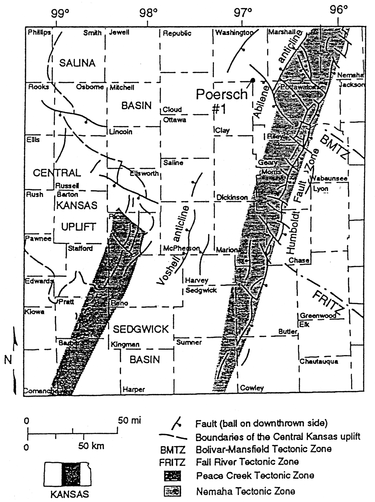
The last published map to show the configuration of Precambrian rocks in Kansas was prepared by Cole (1976). On that map he shows the Humboldt fault along the east side of the Nemaha uplift and a fault along the trace of the Voshell anticline in McPherson and Harvey counties. The structure on top of the north-northeast-trending Nemaha uplift is interpreted as a string of anticlines or domes, alternating with low areas. Cole (1976) also shows northwest-trending faults intersecting the Humboldt fault.
We interpret the Humboldt Fault Zone (fig. 1) to be a prominent fault bounding the rift on the east side. The fault is a complex structure consisting of a number of narrow, commonly anastomosing, high-angle normal or reverse, down-to-the-east fault slices. The Nemaha uplift west of the Humboldt Fault Zone is a granite-cored structural high, about 30 km (18 mi) wide at the Kansas-Nebraska border and narrowing down to almost nothing at the Kansas-Oklahoma border. In contrast to earlier interpretations, we view the anticlinal structures on top of the Nemaha uplift to be mostly tilted, fault-bounded blocks, some of which may have anticlinal closures associated with them. Because of its complex fault-dominated structure, Berendsen and Blair (1986) prefer to use the term Nemaha Tectonic Zone for this area of basement-cored domal culminations and alternating, faulted, and locally deep, pull-apart grabens. Even though Kansas was far removed from any active plate boundaries during the Phanerozoic, the Carboniferous Ouachita orogeny had a profound effect on the tectonic development of the area (Berendsen and Blair, 1986).
The major rift-bounding structure on the west side of the Midcontinent Rift System in Kansas is referred to as the Peace Creek Tectonic Zone (fig. 1; Berendsen and Blair, 1986). It is recognizable in the subsurface in southern Kansas, but cannot be mapped into the Salina basin, because of the paucity of available data. Other major structures associated with the central portion of the rift include what has been referred to as the Abilene anticline (Jewett, 1951) and structures on strike with it to the south.
The fault patterns shown on our maps are similar to patterns observed in the outcrop belt in Minnesota. Wisconsin, and Michigan.
Figure 1—Location of study area shown on maps M-45:1 and M-45:2.
This study of the Midcontinent Rift System was supported by a grant of the U. S. Geological Survey (Award No. 018785-910). The support and cooperation of William Cannon, U. S. Geological Survey, is much appreciated. The work also benefitted from numerous discussion with colleagues and students at the Kansas Geological Survey. Gina Ross and her staff in automated cartography were helpful in the preparation of the maps.
Berendsen, P., 1994. Review of Precambrian rift stratigraphy; in, Revision of Stratigraphic Nomenclature in Kansas, D. L. Baars, compiler: Kansas Geological Survey, Bulletin 230, p. 1-4
Berendsen, P., 1995, Consequences of neotectonic recurrent movement along Precambrian structures on the stratigraphic record, midcontinent U.S.A.: Geological Society of America, Abstracts with Programs, v. 27, no. 6, p. A229
Berendsen, P., and Barczuk, A., 1993, Petrography and correlation of Precambrian clastic sedimentary rocks associated with the Midcontinent Rift System: U.S. Geological Survey, Bulletin 1989-E, 20 p. [available online]
Berendsen, P., and Blair, K P., 1986, Subsurface structural maps over the Central North American Rift System (CNARS), central Kansas, with discussion: Kansas Geological Survey, Subsurface Geology Series 8, p. 1-16 [available online]
Bickford, M. E., Van Schmus, W. R., and Zietz, I., 1986, Proterozoic history of the midcontinent region of North America: Geology, v. 14, p. 492-496
Blair, K. P., Berendsen, P., and Seeger, C. M., 1992, Structurecontour maps on the top of the Mississippian carbonates and on the top of the Upper Cambrian and Lower Ordovician Arbuckle Group, Joplin 1° x 2° quadrangle, Kansas and Missouri: U.S. Geological Survey, Miscellaneous Field Studies Map MF-2125-C (with text) [available online]
Cole. V. B., 1976, Configuration of the top of Precambrian rocks in Kansas: Kansas Geological Survey, Map M-7, scale 1:500,000 [available online]
Dickas, A. B., and Mudrey, M. G., 1989. Central North American case for segmented rift development: 28th International Geological Congress, Washington, D.C., v. 1 of 3, p. 1-396, 397
Geological Society of America, 1982, Geology and tectonics of the Lake Superior Basin: Geological Society of America, Memoir 156, Geologic Map, Plate 1
Hampton, L. B., and Berendsen, P., 1996. Precambrian metasedimentary rocks in the subsurface of eastern Kansas and western Missouri-Preliminary provenance and geochronologic data: Geological Society of America, Abstracts with Programs, v. 28, no. 6, p. 42
Jewett, J. M., 1951, Geologic structures in Kansas: Kansas Geological Survey, Bulletin 90, pt 6, p. 105-172 [available online]
Morey, G. B., and Ojakangas, R. W., 1982, Keweenawan sedimentary rocks of eastern Minnesota and northwestern Wisconsin; in, Geology and Tectonics of the Lake Superior Basin, R. J. Wold and W. J. Hinze. eds.: Geological Society of America, Memoir 156, p. 135-146
Sims, P. K., (compiler), 1990, Precambrian basement map of the northern midcontinent, U.S.A.: U. S. Geological Survey, Miscellaneous Investigations Series, Map IMAP-1853-A, scale 1: 1,000,000 [available online]
Sims, P. K., and Peterman, Z. E., 1986, Early Proterozoic Central Plains orogen—A major buried structure in the north-central United States: Geology, v. 14, p. 488-491
Van Schmus, W. R, and Bickford. M. E., 1993, Transcontinental Proterozoic provinces; in, The Geology of North America, vol. C-2, Precambrian-Conterminous U.S., W. R. Van Schmus and M. E. Bickford, eds.: Geological Society of America, v. C-2
Van Schmus, W. R., Martin, M. W., Sprowl, D. R., Geisman, J., and Berendsen, P., 1990, Age, Nd, and Pb isotopic composition and magnetic polarity for subsurface samples of the 1,100-Ma midcontinent rift Geological Society of America, Abstracts with Programs, v. 22. no. 7. p. A174
Woelk, T. S., and Hinze, W. J., 1991, Model of the Midcontinent Rift System in northeastern Kansas: Geology, v. 19, p. 277-280
Yarger, H. L., 1983, Regional interpretation of Kansas aeromagnetic data: Kansas Geological Survey, Geophysics Series 1, 35 p. [available online]
Kansas Geological Survey
Placed on web Nov. 21, 2018; originally published 1996.
Comments to webadmin@kgs.ku.edu
The URL for this page is http://www.kgs.ku.edu/Publications/Bulletins/Map45/index.html