Kansas Geological Survey, Mineral Resources Circular 4, originally published in 1938
Originally published in 1938 as Kansas Geological Survey Mineral Resources Circular 4. This is, in general, the original text as published. The information has not been updated. An Acrobat PDF version (7 MB) is also available.
During the last ten years western Kansas has grown from a one-pool (the Fairport) oil district to one of many fields and constantly growing importance. Central-western Kansas is underlain by a broad arch of very old rock, known as the Central Kansas uplift. This structural feature has been responsible for the regional accumulation of oil in Rooks, Ellis, Russell, Rush, Barton, Ellsworth, and Rice counties. One of the least tested of these counties is Rush County. Consequently, it was thought desirable to prepare a brief bulletin on the geology and oil and gas resources of this county in the hope that the publication of such a bulletin would lead to wise investment in the further exploration of this part of Kansas.
Most of the field work on Which this report is based was done during the summer of 1930,When one of the writers (Landes) assisted by Mark Alexander, mapped the geology of the county. A special study of the oil and gas industry of the county was made by Francis E. Mettner during the summer of 1935.
In this bulletin the sections on the stratigraphy of the buried rocks and on the subsurface structure were prepared by N. D. Newell and Raymond P. Keroher, the balance by K. K. Landes.
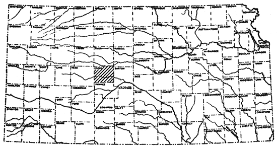
Rush County lies 50 miles west of the center of the state (Fig. 1). LaCrosse, with a population of about 1,400, is the largest town, lying just north of the center of the county. It is the county seat. Rush County is crossed in an east and west direction by the Missouri Pacific Railroad and the Scott City branch of the Santa Fe. The former crosses the county through LaCrosse, and the Santa Fe crosses the south half of the county. Towns along the Missouri Pacific from west to east are McCracken, Hargrove, LaCrosse, Bison, and Otis. Santa Fe towns are Alexander, Nekoma, Rush Center, Timken, and Shaffer. Liebenthal, a small settlement near the north county boundary, is not on a railroad.
Figure 1--Index map of Kansas showing location of Rush County
Three state highways cross Rush County. Kansas highway No. 1 runs south from Hays and passes through Liebenthal, LaCrosse, and Rush Center. The other two cross the county from east to west. Highway K 4 parallels the Missouri Pacific and K 96 the Santa Fe.
The average elevation in Rush County is in the neighborhood of 2,000 feet. The topography over most of the county is that of a gentle rolling plain. An exception occurs along the northern tier of townships where northward flowing tributaries of Smoky Hill River have cut steep-walled valleys into the bed rock.
Most of Rush County is drained by Walnut Creek which enters Arkansas River near Great Bend. Smoky Rill River, which is in the Missouri River basin, crosses southern Ellis County, with one loop extending into Rush County for a very short distance. The northern fourth of the county drains into this river. A few square miles along the southern border of the county drain into Arkansas River by means of tributaries other than Walnut Creek, such as Pawnee River.
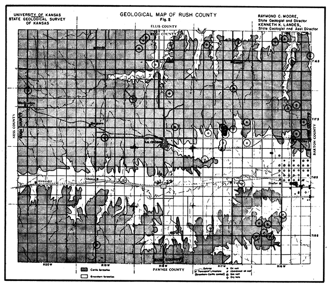
All of the outcropping formations in Rush County with the exception of stream alluvium belong to the Cretaceous system. The very uppermost part of the Dakota formation and the Graneros shale occur at the surface in the deeper stream valleys at the east end of the county. Elsewhere these formations are buried beneath younger rock. The northward sloping valleys in the northern part of Rush County tributary to Smoky Hill River expose the limestones and soft shales of the Greenhorn formation. The outcrop of this formation crosses the county from east to west in the valley of Walnut Creek, and extends up the tributary valley of Sand Creek to the eastern edge of LaCrosse. The Greenhorn formation is exposed over a considerable area adjacent to the southeastern corner of Rush County in the headwater valleys of Little Walnut Creek. Practically all of the remainder of the county is floored with Carlile shale which immediately overlies the Greenhorn formation. The Fort Hays member of the Niobrara limestone crops out over a very limited area in the extreme northwestern quarter of the county.
The Greenhorn-Carlile contact is shown in figure 2 by a dotted line. Practically all of the bed rock in the county above (topographically) this line is Carlile shale (stippled), and the rock below is Greenhorn limestone and chalky shale.
Figure 2--Geological map of Rush County
The greater part of Rush County is mantled with soil derived from the underlying bed rock. Because the underlying rock is calcareous over the greater part of the county, belonging to either the Fairport member of the Carlile shale or to the Greenhorn formation, the soils are rich in lime and very productive.
The larger stream valleys in the county are floored with recent alluvium consisting for the most part of silt, but also containing lenses of sand and gravel. The sand and gravel have been derived from nearby Cretaceous limestones and from the Tertiary Ogallala formation, which has been stripped from Rush County by erosion, but which caps the high hills and divides in Ness County to the west.
The highest hills in the northwest corner of the county are capped with the lowermost chalk beds of the Niobrara formation. These chalk beds lie entirely within the Fort Hays limestone, the lower member of the Niobrara. The Fort Hays limestone consists of thick massive beds of chalk separated by thin beds of chalky shale. The average thickness of the chalk beds is 3 feet while the shale partings are rarely more than 4 inches thick. The chalk where fresh is light-gray in color but weathers to a cream or buff.
The Carlile formation is nearly 300 feet thick, contains mainly shale, and lies below the Niobrara and above the Greenhorn formations. In Rush County the Carlile veneers the upland and has altered to soil to such an extent at the surface that exposures are rare. The soil of the Carlile, especially in the lower part, is very fertile and some of the best farming land in Kansas is to be found along the outcrop of this formation.
The Carlile was divided by Rubey and Bass, working in Russell County, into a lower member which they named the Fairport and a higher member which had previously been named the Blue Hill. Moss working to the west of Rush County, found the Blue Hill member to be 175 feet thick and the Fairport member 115 feet. [Moss, R. G., The Geology of Ness and Hodgeman Counties Kansas Geol. Survey, Bull. 19, 1932, available online.] As a general rule it is impossible to distinguish these members in Rush County. However, as most of the Carlile in this county lies within 115 feet of the "fence-post limestone" (which marks the top of the Greenhorn), it can be assumed that the greater part of the outcropping Carlile in Rush County is the Fairport member. [Rubey, W. W., and Bass, N. W., Geology of Russell County, Kansas: Kansas Geol. Survey, Bull. 10, pp. 32-44, 1925, available online.]
The Blue Hill member is predominantly a noncalcareous clay shale which does not have as much fertility as the Fairport. When wet this shale becomes an exceptionally sticky gumbo mud. A zone of so-called "cannon-ball" concretions lies near the top of the member.
The Fairport member consists dominantly of calcareous shale, but it also contains a few thin limestones in the lower part. About 6 feet of lowermost Fairport is exposed in the southeast corner of sec. 17, T. 16 S., R. 16 W., on a westward-sloping hill facing Duck Creek. Immediately above the "fence-post limestone" is a chalky shale 5 feet 1 inch in thickness containing four zones of discoidal concretions. The concretions range up to 4 inches in thickness and are discontinuous laterally within a zone. The chalky shale is overla in by 3 1/2 inches of bentonite which is overlain in turn by a 4 1/2 inch bed of limestone. The latter is fine-grained, homogeneous, and white in color; it has a tendency to weather into three slabs of approximately equal thickness.
The Greenhorn covers a large area and is the most important surface formation in Rush County. At the top is a 9 inch limestone known as the "fence-post limestone" or "post rock" which has been extensively quarried for building use and fence-posts. This bed and to a lesser extent other limestones in the upper part of the Greenhorn formation can be used by geologists in structure mapping. The outcrop of the "fence-post limestone", the upper surface of which marks the contact between the Greenhorn limestone and the over11ing Carlile shale, is shown by a dotted line on the map (Fig. 2) which accompanies this report.
The Greenhorn formation averages about 108 feet in thickness in Rush County. It consists dominantly of shale, but due to the greater resistance to erosion the thin limestones in the upper half of the formation are the more prominent. These limestones rarely exceed a foot in thickness and the most are but 5 or 6 inches. The shale is highly calcareous, similar to that in the overlying Fairport member of the Carlile shale, but quite dissimilar to the underlying clay shale of the Graneros formation.
The divides between the major stream valleys in Rush County are capped with Carlile shale. Beneath the Carlile and outcropping extensively along the sides of the valleys is the Greenhorn formation. The best exposures are to be found in the northern part of the county where the northward-flowing tributaries of Smoky Hill river have cut through the Greenhorn in steep-sided rock-walled canyons. In the southern part of the county the relief is less and, although present over a large area, the Greenhorn formation is not well exposed.
The Greenhorn formation has been divided into four members. [Bass, N. W., The Geology of Ellis County, Kansas: Kansas Geol. Survey, Bull. 11, p. 31-33, 1926.] These are from top to bottom the Pfeifer, Jetmore, Hartland, and Lincoln. A brief description of the members follows:
The Pfeifer member lies. immediately beneath the thick and relatively soft Carlile shale formation. The "fence-post limestone" at the top is the most easily traced bed in the Greenhorn formation. The base of the Pfeifer is at the bottom of a shale zone several feet thick which immediately overlies the shell rock at the top of the Jetmore member. The "post rock" is about 9 inches thick in Rush County, and contains a prominent reddish-yellow iron seam between 1 1/2 and 2 1/2 inches above the base. Mile after mile of outcrop of this thin limestone is marked by quarries. Five or six feet immediately underlying the post rock are several beds of limestone concretions, anyone of which may thicken to make a continuous limestone bed. A few feet lower (about midway in the Pfeifer section) is a 3-inch limestone Which contains abundant Inoceramus labiatus shells, which is more characteristic of the Jetmore limestone than. of those of the Pfeifer member. The balance of the Pfeifer section consists of chalky shale. This member averages 16 feet in thickness in Rush County.
The Jetmore member contains more hard limestone beds than any of the other members, and in consequence its outcrop tends to be marked by steep slopes which are covered with white limestone debris. The "shell bed" which lies at the top of the member is about a foot thick and is sufficiently resistant to erosion to make a distinct bench, the first one at all continuous laterally above the Dakota formation, The "shell bed" contains abundant Inoceramus labiatus shells and a lesser number of coiled cephalopods. It has also been quarried for use as fenceposts, but does not make good dimension stone. Below this bed are about a dozen thin limestones, separated by thicker beds of chalky shale. The limestone beds in the upper part of the Jetmore are more resistant to erosion than those in the upper part of the Pfeifer. The Jetmore member averages 22 feet in thickness in Rush County.
The Hartland and Lincoln members make up the lowermost 70 feet of the Greenhorn formation. These members are rarely exposed because they lack resistant strata. The Hartland member consists predominantly of shale which is very calcareous and somewhat fissile. It varies in color from blue-gray where freshly cut to cream and even tan, but does not approach the strong yellow shades of the underlying Lincoln shale. A few beds of soft shaly limestone up to 6 inches thick occur in the Hartland. These are not persistent laterally, however, The most characteristic feature of the Hartland is its abundant beds of bentonite. From five to ten bentonite beds ranging from an inch to 6 inches in thickness occur in this member. The bentonite is invariably tinted yellow and even red due to the presence of hydrous iron oxide.
The Lincoln member consists of calcareous shale and a number of thin coarsely crystalline limestone beds (Lincoln "marble"). The latter emit a petroleum odor from fresh fractures. The shales from the Lincoln member are gray on first exposure but invariably weather to deep tan, brown, or yellow. This member can be recognized where crossed by roads by the yellow color of its residual soil, which is in decided contrast with the cream color of the soil from higher members of the Greenhorn and with the gray color of the underlying Graneros shale. At the base of the Lincoln member (and the Greenhorn formation) is a coarsely crystalline limestone of variable thickness and highly fossiliferous composition. It is a mass of shark teeth, fish remains, fragments of Inoceramus shells, and calcium phosphate nodules. It represents a transition between the non-calcareous Graneros and the much more calcareous Greenhorn sediments.
The Graneros shale and the uppermost part of the Dakota formation occur near the bottom of the deeper stream valleys near the eastern border of Rush.County. They are very poorly exposed, however. The Graneros consists of 21 to 36 feet of a blue clay shale which weathers to a very sticky gumbo. The uppermost Dakota in Rush County is a loosely cemented brown sandstone. It consists of quartz grains stained by hydrous iron oxide.
[in part by Norman D. Newell]
Rush County lies over the southwestern flank of a broad buried arch, the Central Kansas uplift. [Morgan, L. C., Central Kansas Uplift: Am. Assoc. Petroleum Geologists, Bull., vol. 16, pp. 483, 484, 1932. Koester, Edward A., Geology of Central Kansas uplift: Am. Assoc. Petroleum Geologists, Bull., vol. 19, pp. 1405-1426, 1935.] According to recent investigations the Central Kansas uplift is a repeatedly "rejuvenated structural feature trending northwest and southeast across west-central Kansas.... It originated in pre-Cambrian time as a series of parallel batholiths and persisted as a positive element thoughout much of Paleozoic time. Several periods of broad warping and erosion occurred during the Paleozoic and Mesozoic eras. [Koester, Edward A., Idem., p. 1405.]
Within the central area of the uplift are two northwest-southeast trending structural highs or "ribs" situated above corresponding high areas in the basement rocks. These collectively form the nucleus of the major structure, and have been named the "Russell rib" and the "Rush rib". Only the Rush rib passes through Rush County.
The Rush rib, which crosses the northeast part of the county, constitutes the chief structural feature within the county limits. The sedimentary section above the high areas over the rib is relatively thin, due to transgressive overlaps and truncation, so that locally the mid-Pennsylvanian "Oswald lime" rests directly on the pre-Cambrian core of the uplift. Middle and Lower Paleozoic sediments beneath the Pennsylvanian in southwestern Rush County wedge out against the flanks of the uplift, where they are overlapped by Pennsylvanian beds.
The depth to pre-Cambrian rocks, due to the absence of the older Paleozoics on the structurally high areas, varies greatly in different parts of the county, ranging from about 3,500 feet below the surface over the Rush rib in the eastern part of the county to an estimated depth of about 4,600 feet in the extreme southwest corner. In the latter area a more nearly complete Ordovician and Mississippian section should be encountered.
Data from drillers' logs form the chief basis for the following discussion. However! considerable information obtained from the study of drill cuttings was made available through the cooperation of a number of petroleum geologists. The subsurface units are correlated with the divisions recognized and published by Betty Kellett. [Geologic Cross-section from Western Missouri to Western Kansas: blue-print chart prepared for the Sixth Annual Field Conference of the Kansas Geological Society, 1932.]
From 500 to 600 feet of Cretaceous and younger rocks are present in Rush County. These include the Comanchean, Dakota, and the lower part of the Colorado group, which are overlain by a thin covering of soil, sand, and gravel. Few subdivisions of Cretaceous rocks can be differentiated accurately by means of drillers' logs. In most places, Comanchean and Dakota beds consist of 300 to 350 feet of heavy sandstone beds and interlayered variegated shales. The Colorado group is composed of dark shale containing several thin limestones.
Cimarron series. The top of the Permian Redbeds in most places in Rush County is 500 to 600 feet below the surface. The "Redbeds," or Cimarron series, is readily divisible into three parts. The upper division consists of brick-red shale and sandstone and thin beds of anhydrite. It varies in thickness from 550 to 600 feet. The "Stone corral," which forms the middle member, is a persistent dolomite, which is easily recognized in almost every well in the county. The thickness, as logged by drillers, varies from 10 to 50 feet. The third division of the Cimarron, lying below the "Stone corral", is 150 to 200 feet thick.
Big Blue series. The Wellington formation occurs immediately below the Cimarron series. It consists of 150 to 250 feet of greenish and gray shales containing, near the middle, a thick bed of red shale. The red shale bed measures up to 100 feet thick in some wells and might easily be confused with the lower Cimarron section.
The Gueda salt is underlain by 800 to 900 feet of alternating thin limestones and variegated shales of lower Permian age. A number of thin but persistent red shales occur within this section. In most wells these are recognized and logged by drillers. The stratigraphic interval between any two of these red shales is quite uniform. The red marker beds that can be recognized in the logs of most of the wells throughout the county are identified as follows, in descending order: basal Pearl shale, Gage shale, Blue Rapids shale, and Eskridge shale. The limestone and shale members which separate the red marker beds are classified according to their position by hyphenated terms, for example, the Cottonwood-Kinney division includes the undifferentiated beds between the recognizable Eskridge shale and the Blue Rapids shale.
The relatively shaly Admire group occurs at the base of the Permian. It is well defined at the top by the overlying thick Foraker limestone formation. The base of the Admire cannot be so precisely located, however. It is arbitrarily indicated at the base of sporadic red shales and sandstones which occur at about the proper stratigraphic position for this boundary in the accompanying correlated sections. (See plates I and II.)
The Wabaunsee group, comprising some 250 to 350 feet of thin limestones and thicker shales, underlies the Admire group. Three subdivisions in the Wabaunsee can be recognized in the drillers' logs of most wells. The Wakarusa-Tarkio division contains thick limestones at the top and bottom and is underlain by the thin, red Soldier Creek shale. The Severy-Howard division is well defined at the top by the contrast between. the relatively thick Howard limestone and overlying shales. The Severy shale below the Howard and at the base of the Wabaunsee is not very conspicuous and is not recognizable in some logs.
The Shawnee group is recognizable as a unit, but cannot be subdivided in drillers' logs. It is notable for the relatively great development of limestone, with very little interbedded shale.
The Shawnee "lime" is not everywhere well defined at the top, where the inconspicuous Severy shale locally seems to thin out and the Howard limestone appears to merge with the thick limestone beds below. Presumably the upper Shawnee is the "Topeka lime" of the drillers, although the term undoubtedly is applied to the Howard limestone by some persons. The Shawnee division, Which is dominantly limestone, varies in thickness from 270 to 290 feet.
The Douglas division underlies the Shawnee beds. It consists of 10 to 40 feet of shale, containing a prominent red layer, which is an excellent marker bed throughout much of eastern and central Kansas.
Beds classed as Bronson-Lansing underlie the Douglas shale. These rocks, measuring from 190 to 260 feet in thickness, consist principally of limestone, with only a few thin shale beds, which are not logged consistently. One fairly persistent thin red shale near the base is indicated in the logs of most wells.
The Bronson-Lansing division overlaps all older beds without appreciable thinning over the buried pre-Cambrian hills. The peak areas of the basement rocks are directly in contact with these limestones. Older Pennsylvanian rocks occur laterally on the slopes of the pre-Cambrian uplifts but are missing locally on the higher areas. The lower pennsylvanian divisions recognized in eastern Rush County are, in descending order: Marmaton-Bourbon (probably very little Bourbon present) and "Sooy conglomerate" (basal Pennsylvanian). The thicknesses of all divisions of pre-Pennsylvanian age are highly variable due to overlap and truncation. The aggregate thickness may not exceed 400 feet in the eastern part of the county.
The Marmaton-Bourbon division, as here recognized, consists of relatively thin alternating beds of red shale and gray limestone, ranging up to a maximum thickness of approximately 70 feet.
The "Sooy conglomerate" ordinarily is logged as variegated shales, sandstones and conglomerates, and is identified by its position at the base of the Pennsylvanian sequence. The "Sooy conglomerate" rests on truncated Lower Paleozoic and pre-Cambrian rocks. Probably the conglomerate is not of the same age throughout, but represents the initial Pennsylvanian deposit, decreasing in age over the crests of the Central Kansas uplift.
This clastic unit is the important gas and oil producer of the area. The structural relief on the "Sooy conglomerate" is much greater than that of higher beds and the interval between the base of the Bronson-Lansing and the top of the "Booy conglomerate" is highly variable. The chief structural features shown by the "Sooy conglomerate", and even the pre-Cambrian surface, are reflected in a subdued way by higher formations.
The truncated "Siliceous lime" or Arbuckle formation, occurs immediately below the Pennsyivanian "Sooy conglomerate". This division, of Cambro-Ordovician age, commonly is logged as cherty or sandy dolomitic gray limestone. In eastern Rush County it ranges in thickness up to 140 feet. That the "Siliceous lime" itself is an overlapping formation is indicated by the wedging out of the underlying "Basal sand" over the crest areas of the Rush rib.
The "Basal sand", commonly correlated with the Reagan or Lamotte sandstones of Oklahoma and Missouri, is the basal Paleozoic deposit. It rests over the uneven topography of an old pre-Cambrian surface. Possibly this basal clastic deposit, like the "Sooy conglomerate", is relatively younger on the higher parts of the uplift, representing progressive encroachment of deposition on the flanks of the topographic prominences. Koester says "In wells close to or on the uplift it is clearly Canadian or upper Ozarkian. Its correlations on the uplift with the Reagan or Lamotte is therefore untenable." [Koester, Edward A., Op. Cit., p. 1418.]
The "Basal sand" is as much as 80 feet thick in some wells.
The surface and near-surface rocks in Rush County dip a little east of north at the rate of about nine feet per mile. This dip is characteristic of the surface rocks over a wide area in western and northwestern Kansas both in direction and amount.
The relationship of Rush County to the pre-Cambrian surface is favorable for the accumulation of petroleum. The eastern and northern parts of the county lie high on the Central Kansas uplift. The southwestern part of the county is on the flank of the uplift which slopes into the Dodge City or Anadarko Basin. The Otis gas field overlies the highest point on the Central Kansas uplift in Rush County, where the pre-Cambrian surface lies at an elevation of a little less than 1,600 feet below sea level.
The surface structure of Rush County has been mapped by the Kansas Geological Survey on a reconnaissance scale only. The outstanding feature is the southestward continuation of the Fairport-Natoma anticlinal trend of western Russell and southeastern Ellis counties across eastern Rush County to near the Pawnee County line where it appears to die out. This anticline, very productive of oil in Russell County, is a northward-plunging anticlinal nose in Rush County. It has a maximum width of about 7 miles, with a very noticeable tendency to divide into two northward-plunging anticlinal folds with a shallow syncline between. The Bison gas field lies on the western one of these two anticlinal ridges and the Otis field overlies the eastern one. Part of the latter field occurs on the flood plain of Walnut Creek, which makes it impossible to obtain much detail in regard to the surface structure. The western side of the Fairport-Natoma fold is marked by a well-defined northward-plunging syncline in central and northern Rush County. Farther to the west in Rush County are one or two more northward-plunging anticlinal noses, but these lack the magnitude and persistence of those along the Fairport-Natoma trend.
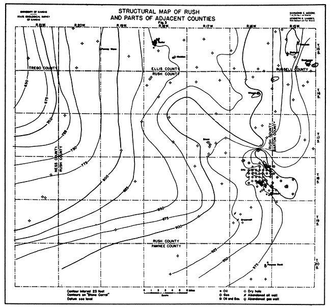
Attempts to map the subsurface structure in eastern Rush County with the aid of drillers' logs were most successful when the "Stone corral" division of the Cimarron series was used as the datum. The map contoured on the "Stone corral" shows a similar but more subdued structural pattern than that displayed by older formations down to the "Oswald" horizon. The greatest structural relief, representing the total uplift through geologic time, is shown by the pre-Cambrian surface. (Fig. 3)
Figure 3--Structural map of Rush and parts of adjacent counties.
Due to the small number of wells drilled, the amount of information available throughout the western two-thirds of the county is very limited. Six of the twelve western townships do not have a single well, while three others have only one each. Furthermore, the geologic section in the western rart of the county appears to vary considerably from that in the eastern part. Whether this apparent variation is merely due to inaccuracies in the drillers' logs, or whether it is real cannot be definitely determined from the small amount of information at hand.
The thinning out or disappearance, of the Gueda salt in the western part of the county probably introduces a factor of error in determining the structural attitude of the stratigraphically higher formation. It would be extremely difficult to determine either the nature or the amount of this error. Future drilling in critical areas may throw further light upon the effect produced by the thinning of the salt bed.
The major structural feature in Rush County is a large antiCline, the axis of which passes into southeastern Rush County from southwestern Barton County. It trends in a general northwesterly direction across the eastern half of the county. Contours drawn on the "Stone corral" indicate that the highest point on the anticline occurs in T. 18 S., R. 16 W. The anticline plunges moderately toward the northwest, disappearing in T. 16 S., R. 18 W. A broad, Shallow syncline parallels the anticline on the southwest. This syncline may be a northern reentrant of the Dodge City Basin; however, lack of control in this part of the county will permit only the broadest generalizations to be made. A smaller and perhaps local syncline parallels the anticline on the northeast. A small local dome occurs near the center of T. 16 S., R. 16 W. This small structure is probably responsible for the accumulation of oil in the Winget field. Similar local highs in T. 17 S., R. 17 W., and T. 19 S., R. 16 W., account for the Bison and Greenwald pools respectively. The structural pattern shown by the "Oswald" lime is similar to that of the "Stone corral," The relief is over 200 feet in the Otis area. Data on the "Oswald" lime are not considered so reliable due to the difficulty in determining precisely the upper contact in many logs.
A relief of 300 to 400 feet on the pre-Cambrian surface is indicated in the Otis field. The maximum between the lowest pre-Cambrian point in the county and the highest point in T. 18 S., R. 16 W., is estimated at well over 1,000 feet.
Undoubtedly future drilling along the Rush rib and adjoining area will supply information for making more detailed and more accurate structural maps. Geologic conditions comparable to those in the Otis field may be expected in other parts of the structurally high areas.
The files of the Kansas Geological Survey contain records of the drilling of 111 wells in Rush County. Of this number, 39 are gas wells, 12 are oil and gas wells, and 15 are oil wells, 2 of which have been abandoned. The remaining 45 are dry holes. The leading field in the county is the Otis field. Other pools in the county are the Winget, the Bison, and the Greenwald (abandoned). The Albert pool of southwestern Barton County also extends northwest into Rush County.
The first oil tests drilled in Rush County were the H. Rages and Company No. 1 well in the southeast corner of section 33-17-17 and No. 2 well in the SW corner NW of section 34-17-17. The first well was abandoned at a depth of 2,004 feet; the second well, also a dry hole, was drilled to a total depth of 2,095 feet. These wells were drilled in 1903 when the relatively insignificant Kansas production was obtained entirely from counties in the eastern part of the state. The next well drilled was the Charles F. Noble No. 1 Wallace in the SW of section 3, T. 16 S., R. 16 W. This well was abandoned in October, 1924, at a total depth of 3,610 feet.
The first successful well was the Danciger Oil and Refining Company's No. 1 Bison in the center of the NW of section 27 T. 17 S., R. 17 w. it was completed as a 13-million foot gas well in November, 1928. The Otis field was discovered in March, 1930, with a 16 1/2-million foot gas well. The first well to produce oil in this field was completed on July 1, 1934. The Greenwald oil pool was discovered in August, 1931. The Winget oil pool was discovered in December, 1936. A compilation of wells drilled in the county follows:
| Well Completions in Rush County | |||
|---|---|---|---|
| Company. Farm. |
Location. Section. |
Compl. Date. Total Depth. |
Prod. |
| Township 16 S., Range 16 W. | |||
| Pryor and Lockhart Wallace 1 |
Cen SW Sec. 3 |
10/16/1924 3620 |
Dry |
| Sinclair O. G. Beeching 1 |
NW NE NW Sec. 9 |
3/15/1929 3773 |
Dry |
| Duwe and Brouk Lebsack 1 |
SE NE Sec. 13 |
6/29/1937 3512 |
Dry |
| Shoenfeld-Kitch-Hunter Suppes 1 |
SW SW Sec. 14 |
5/27/1937 3559 |
297 Bbls. |
| Shoenfeld and Kitch Winget 1 |
SE SE Sec. 15 |
1/20/1937 3247 |
797 Bbls. |
| Texas George Wagner 1 |
NE NE Sec. 22 |
5/4/1937 3274 |
491 Bbls. |
| Courtney B. Davis Brack 1 |
NW NW Sec. 23 |
5/9/1937 3612 |
Dry |
| Township 16 S., Range 17 W. | |||
| R. B. Downing et al. Jacob 1 |
SW SE NW Sec. 8 |
5/19/1936 3604 |
Dry |
| Pryor and Lockhart Stegman 1 |
SW NW NE Sec. 11 |
6/18/1936 3551 |
Dry |
| Bird Hanley-Sheedy Bison 1 |
SW SW Sec. 35 |
11/16/1936 3700 |
Dry |
| Township 16 S., Range 18 W. | |||
| Prairie and Gypsy Leiker 1 |
NW SW SW Sec. 5 |
10/25/1930 3758 |
Dry |
| Earl F. Wakefield et al. Zimmerman 1 |
SE SW Sec. 7 |
10/29/1937 3664 |
Dry |
| National Refining Werth 1 |
NW NE NE Sec. 7 |
6/16/1936 3625 |
Dry |
| Phillips Petroleum Leglerter 1 |
NE NW SE Sec. 10 |
5/17/1929 3760 |
Dry |
| S. A. Murphy et al. Roth 1 |
NW SW Sec. 21 |
7/18/1937 3608 |
Dry |
| Township 17 S., Range 16 W. | |||
| Corbet et al. Schmidt 1 |
C SW SE Sec. 10 |
12/12/1934 3732 |
Dry |
| Wakefield and Brouk Fritz Kerbs 1 |
NW SE Sec. 11 |
12/29/1937 3629 |
Dry |
| McPherson O. G. Brack 1 |
Cen NW Sec. 24 |
10/16/1930 3980 |
Dry |
| Morgan Flyn Cobb Schlegel 1 |
SE NW Sec. 26 |
5/14/1935 3760 |
Dry |
| Piggott et al S. E. Jones 1 |
NW NW Sec. 35 |
8/2/1937 3626 |
51.5 MCF |
| Township 17 S., Range 17 W. | |||
| Barnsdall Oil Brock 1 |
SE SE Sec. 21 |
7/15/1929 3602 |
Dry |
| Danciger Oil and Refining Schleuming 1 |
SW SW Sec. 22 |
8/26/1929 3850 |
Dry |
| Lario Oil and Gas et al Gillig 1 |
NE SE NW Sec. 24 |
8/5/1935 3558 |
Dry |
| Danciger Oil and Refining Neve 1 |
NW NW Sec. 26 |
8/6/1930 3607 |
Dry |
| H. F. Wilcox Schwartzkoph 1 |
NE NW SW Sec. 27 |
6/15/1929 3730 |
Dry |
| Danciger Oil and Refining Bison 1 |
Cen. NW Sec. 27 |
11/21/1928 3578 |
31.2 MCF |
| Valerius-Cheney-Danciger Scheuerman 1 |
Cen. SW Sec. 27 |
11/21/1928 3579 |
4 MCF |
| Twin Drilling et al Appl 1 |
SW NE Sec. 29 |
9/14/1935 3660 |
Dry |
| ------------------- H. Rages 1 |
SE SE Sec. 33 |
/ /1920 2194 |
Dry |
| Rogers Appl 2 |
NW SW Sec. 34 |
/ / 2096 |
Dry |
| El Dorado Refining Stang 1 |
SE NW Sec. 36 |
6/22/1935 3579 |
Dry |
| Township 17 S., Range 18 W. | |||
| Keith et al Scheiderman 1 |
SW SW NE Sec. 3 |
6/20/1936 3705 |
Dry |
| Boyle Grossman Drilling Yost 1 |
C SW SW Sec. 23 |
7/16/1935 3759 |
Dry |
| Township 17 S., Range 19 W. | |||
| Lario-Phillips Petroleum Benbow 1 |
NW NE NE Sec. 12 |
4/10/1935 3825 |
Dry |
| Boyle-Grossman Drilling Wilson 1 |
NE NE Sec. 33 |
7/31/1936 4014 |
Dry |
| Township 17 S., Range 20 W. | |||
| Ramsey Petroleum Darkes 1 |
C W2 NW Sec. 5 |
11/15/1935 4242 |
Dry |
| Township 18 S., Range 16 W. | |||
| Syndicate Oil and Gas Mohr 1 |
Cen. SW Sec. 2 |
9/17/1930 3762 |
Dry |
| Olson Oil Schmidt 1 |
Cen. SE Sec. 4 |
1/7/1936 3546 |
.396 MCF |
| Morgan et al Hartman 1 |
SWc NW Sec. 4 |
9/18/1935 3539 |
13 MCF |
| Sinclair Prairie John Scheuerman 1 |
SE NE Sec. 5 |
5/7/1937 3550 |
3 MCF |
| Interstate Production Schmidt 1 |
Cen. SE Sec. 9 |
7/3/1936 3559 |
5.6 MCF |
| Flynn Oil Eitel 1 |
Cen. SE Sec. 10 |
11/5/1933 3535 |
48 MCF |
| Interstate Production Mohr 1 |
Cen. SW Sec. 10 |
1/29/1935 3507 |
.42 MCF |
| Mid-Kansas Oil and Gas Mohr 1 |
Cen. NW Sec. 10 |
12/17/1934 3581 |
27 Bbls |
| Milmac Oil Eitel Estate 1 |
Cen. NW Sec. 11 |
1/27/1937 3526 |
27.9 MCF |
| Syndicate Oil and Gas Tammen 1 |
Cen SW Sec. 11 |
1/14/1931 3509 |
34 MCF |
| Schermerhorn Oil Hagelgantz 1 |
Cen. SE Sec. 11 |
10/1/1935 3518 |
.52975 MCF |
| Flynn, Northern Natural Gas, Schermerhorn J. B. Mauler 1 |
Cen. SE Sec. 12 |
3/30/1937 3535 |
.515 MCF |
| Marathon Oil Mauler 1 |
Cen. SW Sec. 12 |
1/4/1936 3540 |
47 MCF |
| W. M. Moore Oil and Gas Schroyer 1 |
Cen. NW Sec. 12 |
4/1/1936 3552 |
75 MCF |
| Interstate Production et al Brack 1 |
Cen. NE Sec. 12 |
11/7/1936 3536 |
41 MCF |
| Aylward Production Mohr 1 |
Cen. NW Sec. 13 |
12/11/1935 3530 |
32.5 MCF |
| Schermerhorn Oil Reidl 1 |
Cen. SE Sec. 13 |
11/15/1934 3496 |
46 MCF |
| Aylward Production Reidl 1 |
Cen. NE Sec. 13 |
11/4/1936 3515 |
46 MCF |
| Aylward Production Brack 1 |
Cen. SW Sec. 14 |
9/29/1937 3554 |
43 MCF |
| Schermerhorn Oil Eitel 1B |
Cen. SE Sec. 14 |
2/3/1936 3520 |
8 MCF |
| Mid-Kansas Oil and Gas Mohrs 1 |
Cen. NW Sec. 14 |
1/1/1932 3502 |
36.5 MCF |
| Schermerhorn Oil Mauler 1 |
Cen. NE Sec. 14 |
7/18/1934 3528 |
48 MCF |
| Interstate Production Mohr-Butherus 1 |
Cen. NE Sec. 15 |
10/24/1934 3499 |
43 MCF |
| Schermerhorn Oil Butherus 1 |
Cen. NW Sec. 15 |
12/29/1933 3494 |
39 MCF |
| Marathon Oil Mohr 1 |
Cen. SW Sec. 15 |
1/30/1935 3524 |
26.2 MCF |
| W. M. Moore Mohr 1 |
Cen. SE Sec. 15 |
1/30/1935 3520 |
36.2 MCF |
| Interstate Production Korbs 1 |
Cen. SE Sec. 16 |
11/17/1933 3554 1/2 |
Dry |
| Flynn et al Budde 1 |
Cen. NE Sec. 16 |
5/25/1932 3501 |
45 MCF |
| Carter Oil Company F. Prosch 1 |
C NL SE Sec. 21 |
6/19/1937 3614 |
10 MCF |
| Schermerhorn Oil Maneth Brachley 2 |
SE NE Sec. 22 |
10/26/1936 3562 |
26 MCF 217 Bbls. |
| Schermerhorn Oil Maneth 1 |
Cen. NE Sec. 22 |
2/18/1936 3566 |
6 MCF |
| Morgan-Flynn-Cobb Shaffer 1 |
NE SE Sec. 22 |
10/14/1936 3595 |
Dry |
| Shell Petroleum Shaffer 1 |
Cen. NW Sec. 22 |
7/8/1936 3577 |
Dry |
| Morgan-Flynn Schroeder 1 |
SW NW SE Sec. 23 |
12/10/1936 3538 |
44 MCF |
| Carter Oil Company H. R. Woodward 1 |
SE SE Sec. 23 |
3/29/1937 3550 |
25 MCF |
| Carter Oil Company H. R. Woodward 2 |
SW SE Sec. 23 |
5/31/1937 3560 |
20 MCF 114 Bbls. |
| Carter Oil Company O. Schroeder 1 |
NW SW SE Sec. 23 |
2/5/1937 3539 |
29 MCF 394 Bbls. |
| Flynn Oil Co. et al Koriel 1A |
Cen. NW Sec. 23 |
7/20/1937 3550 |
26 MCF 1587 Bbls. |
| Morgan and Flynn Koriel 2A |
SW NW Sec. 23 |
1/28/1937 3558 |
12 MCF 26 Bbls. |
| Morgan and Flynn Koriel 3A |
C SL NW Sec. 23 |
6/23/1937 3555 |
100 MCF 861 Bbls. |
| Morgan and Flynn Koriel 1B |
NW NW SW Sec. 23 |
7/31/1936 3539 |
2229 Bbls. |
| Morgan and Flynn Koriel 2B |
SE NE SW Sec. 23 |
3/24/1937 3547 |
45 MCF 467 Bbls |
| Flynn Oil Company Koriel 3B |
Cen. N2 SW Sec. 23 |
4/29/1937 3550 |
45 MCF 417 Bbls. |
| Flynn Oil Company Koriel 4B |
NE SW Sec. 23 |
8/15/1937 3555 |
998 Bbls. |
| Flynn Oil Company Koriel 4A |
SE NW Sec. 23 |
10/26/1937 3558 |
3 MCF. 1047 Bbls. |
| Morgan-Flynn-Cobb Schroeder 2 |
NW SE Sec. 23 |
10/6/1937 3552 |
27.5 MCF 1715 Bbls. |
| Interstate Production Crowell 1 |
Cen. NE Sec. 23 |
11/19/1935 3513 |
.37 MCF |
| Morgan-Flynn-Gobb et al Crowell 2 |
SW NE Sec. 23 |
9/28/1937 3555 |
50 MCF 2205 Bbls. |
| Carter Oil Company Wm. Rubart 1 |
SE SE Sec. 24 |
4/10/1937 3543 |
6 MCF 40 Bbls. |
| Marathon Oil and Gas Brock 1 |
Cen. SW Sec. 24 |
4/22/1936 3515 |
28 MCF |
| Hernden Drilling Company P. J. Brack 1 |
Cen. NW Sec. 24 |
11/9/1936 3480 |
38 MCF |
| Ohio Oil Company G. C. Brack 2 |
SW SW Sec. 24 |
9/25/1937 3550 |
1.25 MCF 32 Bbls. |
| Morgan-Flynn Cobb Giesick 1 |
NW SE Sec. 25 |
6/27/1935 3582 |
Dry |
| Schermerhorn-Winton-Shell C. Moore 1 |
NW NW Sec. 25 |
2/11/1937 3558 |
108 Bbls. |
| Schermerhorn-Winton et al Giesick 2 |
SE SE Sec. 25 |
10/13/1936 3619 |
118 Bbls. |
| Ohio Oil Company J. J. Dirks 1 |
NE NE Sec. 25 |
8/27/1937 3566 |
8 MCF |
| Schermerhorn-Winton et al Lillie Strong 1 |
CE2 E2 SW Sec. 26 |
4/28/1938 3580 |
293 Bbls. |
| Dudley D. Morgan Schroeder 1 |
C SL SE NE Sec. 26 |
10/28/1937 3601 |
Dry |
| Carter Oil Company K. Hergert 1 |
CNL NE SE Sec. 26 |
8/13/1937 3553 |
1434 Bbls. |
| H. S. Moss Peter Rodie 1 |
NE NE Sec. 27 |
12/15/1937 3599 |
5 MCF |
| Schermerhorn Oil Corp. Schroeder 1 |
NE NE Sec. 36 |
6/26/1935 3635 |
23 MCF |
| Schermerhorn Oil Corp. Schroeder 2 |
Cen. NE Sec. 36 |
3/7/1937 3657 |
356 Bbls. |
| Carter Oil Company A. Pascoe 1 |
Cen. N2 NW NW Sec. 36 |
11/9/1937 3595 |
150 Bbls. |
| Schermerhorn Oil Corp. Schroeder 3 |
C EL NE Sec. 36 |
12/10/1937 3642 |
477 Bbls. |
| Township 18 S, Range 17 W. | |||
| Sinclair Oil and Gas Co. Seuser 1 |
SE NW N Sec. 8 |
8/18/1929 3837 |
Dry |
| Gypsy Oil Company Kraisinger 1 |
SE NE SE Sec. 23 |
9/21/1935 3720 |
Dry |
| Township 18 S., Range 19 W. | |||
| Wentz et al Kershner 1 |
C SE NE Sec. 23 |
11/16/1930 3885 |
Dry |
| Township 19 S., Range 16 W. | |||
| Barnsdall Oil Schultz 1 |
SW SW Sec. 3 |
10/19/1932 3880 |
Dry |
| Boyle-Grossman Shuey 1 |
NW SE SE Sec. 7 |
5/27/1934 3898 |
*Dry |
| Boyle-Grossman Wilhelm 1 |
SW SE Sec. 8 |
1/18/1935 3946 |
Dry |
| Dewey et al Greenwalt 1 |
Cen. SW Sec. 17 |
9/2/1931 3880 |
400 Bbls. |
| Westgate-Greenland Oil Greenwalt 1 |
NW NW NE Sec. 19 |
6/15/1937 4017 |
Dry |
| Westgate-Greenland Oil Fritz Hagerman 1 |
NE NE Sec. 20 |
8/30/1937 4030 |
Dry |
| Township 19 S., Range 17 W. | |||
| Danciger Oil Refining Pinvoka 1 |
Cen. NE Sec. 17 |
12/21/1929 4147 |
Dry |
| Township 19 S., Range 19 W. | |||
| G. M. Piggott et al Maresch 1 |
C NW NW Sec. 28 |
1/14/1937 4225 |
Dry |
| * Initial production - 600 Bbls. | |||
The discovery well for this field was the Milmac Oil Company's No. 1 Eithel drilled in the center of the NW section 11, T. 18 S., R. 16 W. This well had a good gas show at a depth of 2,332 feet in the Big Blue series of Permian age; another show at 2,350 feet in the same series, a third gas show at 2,600 feet in the upper part of the Virgil series, and a show of oil at 3,295 feet in the "Oswald" limestone. A gas flow of 16 1/2 million cubic feet was found in the Pennsylvanian basal conglomerate at 3,507 1/2 feet. The well was completed at that depth.
The first well to produce oil in the Otis field was the Mid-Kansas Oil and Gas Company's No. 1 J. B. Mohr drilled in the NW section 10, T. 18 S., R. 16 W. This well was first completed July 20, 1934, with an initial production of 153 barrels of 34 degree oil and 12 million cubiC feet of gas. The producing zone was in the Pennsylvanian basal conglomerate at a depth of 3,523-3,536 feet. The well was treated with 1,000 gallons of acid, but with no increase in production. In December of the same year the well was deepened, encountering granite wash between 3,552 feet and 3,581 feet, total depth. The new potential established was 27 barrels of oil, with a gas production of 3 million cubic feet. This well produced 4,009 barrels of oil during 1934 and 2,247 barrels during 1935.
In March, 1936, a second combination oil and gas well was completed. This well, the Schermerhorn Oil Company Maneth No. 1 in the center of the NE section 22, T. 18 S., R. 16 W., had an initial production of 700 barrels of oil and 3 million cubic feet of gas. It is producing from the so-called "Reagan" sand (granite wash) at a depth of 3,547 to 3,566 feet.
The county's largest oil well to date, located about one-half mile southeast of the Maneth well, was completed in August, 1936. This, the Morgan and Flynn No. 1. Koriel in the NW NW SW section 23, T. 18 S., R. 16 W., flowed 1 470 barrels in 12 hours and was given a rated potential of 2,229 barrels a day. Natural gas accompanying the oil gauged 34,600,000 feet. This well topped anhydrite at 976 feet, the Kansas City lime at 3,228 feet, and the LaMotte, "Reagan," or "Basal" sand at 3/511 feet. Both the oil and gas were in this sand between 3,536 and 3,539 feet, total depth.
In addition to the discovery gas well and the three oil and gas wells mentioned, the Otis field now has 34 producing gas wells, 12 combination oil and gas wells, and 4 oil wells. The initial gas productions of these wells range from 42 thousand to 100 million cubic feet. The well which produces 42 thousand cubic feet is something of a freak as it is surrounded on four sides by wells producing from 3 million cubic feet of gas (with some oil) to 48 million cubic feet of gas. The average initial production of gas per well in the Otis field is about 36 million cubic feet.
The limits of the Otis field are largely unknown. Few dry holes have been drilled to date. Two of these, in Rush County in secs. 25 and 26, T. 18 S., R. 16 W., together with two more in sec. 30, T. 18 S., R. 15 W., Barton County, may separate the Otis and Albert fields. However, more intensive drilling in section 26, T. 18 S., R. 16 W. may connect the two pools. Two dry holes in sections 16 and 22, T. 18 S., R. 16 W. appear to limit the field on the west, but a 10,000,000 foot gas well still farther west in section 21 of the same township may mean that the western limit bas not been reached.
The northernmost well in the field, as defined at present, is a 51 1/2 million feet gas well, Piggott et al No. 1 S. E. Jones, NW cor. NW section 35, T. 17 S. R. 16 W. This well is over 2 miles north of the principal producing area of the field. Future drilling may prove that this is an extension of the Otis field. However, the presence of a dry hole, Syndicate Oil and Gas No. 1 Mohr, center SW section 2, T. 18 S., R. 16 W., may be due to a saddle separating the Piggott well from the Otis field. In either case much of the area south of the Piggott well appears to be favorably situated with respect to both structure and proved areas.
A dry hole in section 26, T. 17 S., R. 16 W., one-half mile north of the Piggott well, together with the presence of a marked sync line in that area, appears to define the northern limit of production of the Otis field.
The boundary to the northwest, along the axis of the major anticline, is not definitely established. There appears to be room for several locations between the present producing wells in sections 4 and 5, T. 17 S., R. 17 W., and the nearest dry hole in section 36, T. 17 S., R. 17 W.
The eastern boundary of the Otis field bas not been established. At the present time there is an area in Rush and Barton counties approximately 7 miles in length immediately adjacent to production on the east in which not a single dry hole has been drilled.
In addition to the unproved areas surrounding the Otis field, there are a number of "inside" locations yet to be drilled. The practice of drilling but four gas wells to the section as followed in this field is to be commended.
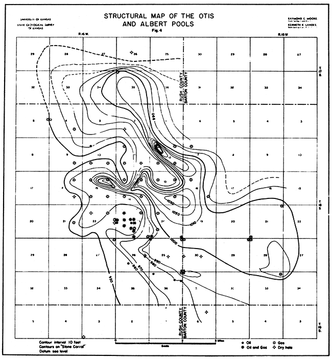
Structurally the Otis field lies above a local high area on the Central Kansas uplift. Pennsylvanian sediments immediately overlie weathered pre-Cambrian rocks throughout most of the field. The structure pattern shown by Pennsylvanian and younger rocks is, perhaps in considerable part, the reflection of topographic features on the pre-Cambrian surface. (Fig. 4)
Figure 4--Structural map of the Otis and Albert pools.
This is a one well field Which is now abandoned. The discovery well, Danciger Oil and Refining Company No. 1 Bison, was completed November 21, 1928, with an initial production of 13,200,000 feet of gas from the Pennsylvanian basal conglomerate at 3,575 to 3,578 feet depth. This well is in the center of the NW section 27, T. 17 S., R. 17 W. Subsequently dry holes have been drilled to the north (SW cor. section 22), northwest (SE cor. section 21), south (NE. cor. NW SW section 27), and east (NW cor. section 26). The nearest dry hole to the west is over a mile and one-half away, in the SW cor. NE section 29.
The Bison gas field is so surrounded with dry holes that it cannot cover, a very large area. However, there is still room for possible productive offsets on the west and southwest and along the east side of the discovery well.
The No. 1 Bison reached the top of the Lansing at a depth of 3,341 feet and the top of the basal conglomerate at 3,573 feet. This well stopped at 3,578 feet, still in the conglomerate. The dry hole to the south, the H. F. Wilcox No. 1 Schwartzkopf in the NE corner NW SW section 27, found the top of the Lansing at 3,339 and the basal conglomerate from 3,570 to 3,611 feet. Below the conglomerate was 52 feet of "Siliceous lime" and Paleozoic basal sand from 3,663 feet to 3,730 feet, total depth.
The Bison gas field lies near the northwestern edge of the same structurally high area that contains the Otis field. The latter field, however, occupies a large node on the subsurface dome, while the Bison field shows no closure whatsoever at the contour interval at which the surface and subsurface structure maps have been prepared. Nevertheless, this field is probably producing from a small closed anticline superimposed upon the large dome.
The first commercial oil well in Rush County was the Dewey et al No. 1 Greenwalt, drilled in the center of the SW section 17, T. 19 S., R. 16 W. This well was completed September 2, 1931, with an estimated initial production of 300 to 400 barrels a day of 430 oil. The oil occurs in Arbuckle limestone Which was topped at 3,815 feet and which carries oil from the top down to about 3,840 feet. The discovery well was drilled to 3,880 feet, got a hole full of water and was plugged back to 3,835 feet. It produced 3,428 barrels of 430 oil up to January 1, 1933. Later it was shut in while a 2-inch pipe line was constructed to a loading rack at Shaffer. During 1934 it produced but 300 barrels of oil and was abandoned in January, 1935. The total production of this one well pool from discovery to abandonment was about 6,000 barrels.
The No. 1 Greenwalt was in Kansas City-Lansing, and Bronson formations between 3,463 and 3,715 feet, Pennsylvanian basal conglomerate from 3,780 to 3,815, and Arbuckle limestone below 3,815.
A second well was drilled in the spring of 1934 a little over a mile to the northwest, in the NW corner SE SE section 7 in the same township. This well, the Boyle Grossman Drilling Company No. 1 Shuey, had an estimated production of 600 barrels a day from Arbuckle at 3,846 to 3,874 feet, but was deepened 24 feet, got a hole full of water, and was abandoned, The same company completed a dry hole, the Wilhelm No. 1, in the SW corner SE section 8.
The discovery well for the Winget field was the Schoenfeld and Kitch No. 1 Winget, in the SE corner SE section 15, T. 16 S., R. 16 W. This well was completed January 20, 1937. It had an initial production of 797 barrels of oil from the "Oswald" lime at 3,247 feet.
The second well drilled in this field, the Texas Company No. 1 George Wagner, NE corner NE section 22, T. 16 S., R. 16 W. was completed May 4 1937. It had an initial production of 49i barrels of oil. It also produces from the "Oswald" lime at 3,274 feet.
The third producing well in this field, the Schoenfeld-Kitch-Hunter No. 1 Suppes, in the SW corner SW section 14, T. 16 S., R. 16 W., was completed May 27, 1937. A show of oil was reported from the "Oswald" lime at 3,410 to 3,435 feet, but the well was completed for 247 barrels in the conglomerate.
One other well, a dry hole, Courtney B. Davis No. 1 Brack, in the NW cor. NW sec. 23, T. 16 S., R. 16 W., was completed May 9, 1937. at a total depth of 3,612 feet. Three other dry holes in the same township, at distances of 1 1/2 to 2 1/2 mlles from the producing wells, do not define the limits of the Winget field.
Six wells in Rush County belong to the Albert pool of Barton County. The first of these wells, the Schermerhorn Oil Corporation No. 1 Schroeder in the NE. cor. sec. 36, T. 18 S., R. 16 W. was completed in June, 1935, as a 23 million cubic foot gas well. However, eight months later, in March, 1936, after being shut in, it flowed 287 barrels of oil in 24 hours with 7 1/2 million feet of gas. Five later wells in sections 25, 26 and 36 have almost connected the Albert field with the Otis pool.
The 45 dry holes Which have been drilled by no means cover the county. Most of these are in the eastern half of the county, nine close to the one-well Bison gas field (of which two were drilled in 1903 and did not go deeply enough to test formations elsewhere productive in the county), six lie on the periphery of the Otis field, and five in T. 16 S., R. 18 W. The remainder are scattered.
There are six townships in Rush County in which no tests whatever have been drilled far oil and gas. In eight more townships only one or two dry holes have been drilled. Consequently, the county contains large areas are yet not adequately tested with the drill, and new discoveries in all likelihood will be made in the future. At the present time Ellis County is receiving a very active play, which has resulted in the discovery of a number of new fields. Two of these fields, the Madden and the Ruder, lie just a short distance north of the Rush County line. In June, 1936, a dry hole was completed in sec. 7, T. 16 S., R. 18 W., Rush County, about 4 miles south of, and on the same trend with the Ruder pool. This well had a hole full of water in the basal sand at 3,625 feet, total depth, and was abandoned. However, it struck oil estimated at 50 barrels a day at a depth of 3,572 feet. After acidizing it made a daily potential of 444 barrels with 2 percent water. Three days later it pumped 100 barrels of oil and 100 barrels of water, and was deepened and subsequently abandoned.
Possibilities for additional oil and gas production in untested areas occur in the lower part of the Pennsylvanian section ("Oswald lime" and higher formations) and in the Pennsylvanian basal conglomerate. These formations underlie the surface over the entire county. On the flanks of the Uplift (Which has its highest point in Rush County beneath the Otis field) the trunca ted Arbuckle ("Siliceous lime") formation and the basal Paleozoic conglomerate afford possibilities of production. The Greenwalt production and many Arbuckle wells to the east in Barton and Rice counties testify to this. The section in western Rush County, down the flank of the Dodge City Basin probably includes the normal sequence between the Arbuckle and the Pennsylvanian, but insufficient deep drilling has been done in that area to prove or disprove this. If this supposition is correct the beveled edges of the Simpson formation (including the "Wilcox" sand), the Hunton, and other potential oil-producing formations, occur beneath the surface in western Rush County.
At the present time six pipe line companies take the gas produced in Rush County. The Northern Natural Gas Company has an 18-inch line from the Otis and Albert gas pools which connects with their 26-inch line to Minnesota. The Kansas Pipe Line and Gas Company bas a 6-inch line to Nebraska and another line to Ness City. The Producers Gas Company has a 4 1/2-inch line to northern Barton County. The Kansas Power and Light Company has a 4- and a 6-inch line to Barton, Russell and Ellis counties. The Central Gas and Utilities Company has a 6-inch line carrying gas to towns farther west in Kansas. The one well in the Bison gas pool was connected with the Kansas Pipe Line and Gas Company line until its abandonment.
No oil lines are in operation in Rush County. A 2-inch line owned by the Golden Rule Refinery, which formerly took the production of the now abandoned Greenwalt pool, is no longer used. Oil from the Winget pool is hauled in trucks to the Kaw Pipe Line Company's oil lines in Barton County. Oil from the Albert pool is taken by the Bay Petroleum Company in tank cars to their refinery at McPherson. Oil from the Otis pool is shipped in tank cars to the. Bay refinery and to the Falcon Oil Company refinery at Great Bend.
Kansas Geological Survey, Oil and Gas Resources of Rush County, Kansas
Placed on web April 13, 2014; originally published in June 1938.
Comments to webadmin@kgs.ku.edu
The URL for this page is http://www.kgs.ku.edu/Publications/Bulletins/MRC4/index.html