![]()
Prev Page--Contents || Next Page--Geology
Introduction
Economic stability and growth in southwestern Kansas depend on the continued availability of ground water for irrigation and other uses. The production of food and fiber from irrigated land in this region is of major significance to the economic well-being of Kansas and the nation. However, ground-water supplies for irrigation from the Ogallala Formation, the principal aquifer in western Kansas, are being depleted because water is being withdrawn at a rate many times faster than it is being replenished by recharge. Sandstone aquifers in underlying consolidated bedrock of Late Jurassic and Early Cretaceous age are being developed to varying degrees for stock, domestic, industrial, and irrigation supplies in certain parts of southwestern Kansas. However, based on present information, the sandstone aquifers have significantly greater potential for additional development.
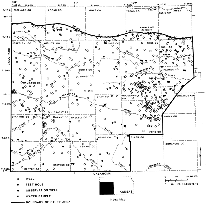
The study area for this report includes all or parts of 26 counties in southwestern Kansas (fig. 1). The area comprises approximately 17,400 mi2 and is bounded on the north by the Smoky Hill River, on the west by Colorado, on the south by Oklahoma, and on the east by the Arkansas River and Barton, Clark, and Kiowa counties.
Figure 1--Location of study area, wells, test holes, and other data sites.
This report presents the results of a geohydrologic study of the sandstone aquifers of Permian, Jurassic, and Cretaceous age in southwestern Kansas conducted in cooperation with the Kansas Geological Survey and the Kansas Department of Health and Environment. The report includes a description of the aquifers and their properties and the chemical characteristics of the ground water from these aquifers. In previous county and state studies, the sandstone units commonly were undifferentiated and were included in a single geohydrologic unit known as the "sandstone aquifer." Because an excessive amount of shale and siltstone also was included in this "aquifer," erroneous conclusions possibly could have been made as to the potential for development of water supplies from this "sandstone aquifer." For a summary of selected reports where the "sandstone aquifer" is addressed, see table 1.
Table 1--Summary of sandstone-aquifer data from selected previous reports. (Thickness is given in feet and is the stratigraphic unit thickness. Yield is given in gallons per minute. Depth to top of aquifer is given in feet. Asterisks [*] indicate units included in the "sandstone aquifer"; "Yes" indicates that the unit yields potable water to wells, but marginal for most uses; "No" indicates that the unit does not yield potable water to wells.)
| Sandstone aquifers |
Finney County |
Grant and Stanton counties |
Gray County |
Greeley and Wichita counties |
Hamilton County |
Haskell County |
Hodgeman and northern Ford counties |
Kearny County |
Lane and Scott counties |
Ness County |
Rush County |
Trego County |
Kansas | ||
|---|---|---|---|---|---|---|---|---|---|---|---|---|---|---|---|
| Gutentag, Lobmeyer, McGovern, and Long, 1972 |
Fader, Gutentag, Lobmeyer, and Meyer, 1964 |
McGovern and Long, 1974 |
Slagle and Weakly, 1976 |
Lobmeyer and Sauer, 1974 |
Gutentag and Stullken, 1974 |
Lobmeyer and Weakly, 1979 |
Gutentag, Lobmeyer, and McGovern, 1972 |
Gutentag and Stullken, 1976 |
Jenkins and Pabst, 1977 |
McNellis, 1973 |
Hodson, 1965 |
Keene and Bayne, 1977 |
|||
| Upper Cretaceous | |||||||||||||||
| Codell Sandstone Member of the Carlile Shale |
|||||||||||||||
| Thickness | 4 | 3-5 | |||||||||||||
| Yield | 5-10 | 5-10 | 0 | small amount | |||||||||||
| Lower Cretaceous | * | * | * | * | * | * | * | * | * | * | * | * | * | ||
| Thickness | 120-460 | 300-400 | 300-500 | 3S0 | 0-260 | 210-380 | 300-680 | 260-690 | 5-500 | 150-250 | 0-850 | ||||
| Yield | 30-1,000 | 500 | 1,000 | 30-300 | 100-2.200 | 30-300 | 30-300 | 20-800 | 100-2,000 | ||||||
| Dakota Formation | * | * | * | * | * | * | * | * | * | * | * | * | * | ||
| Thickness | 0-135 | 100-450 | 150-300 | 200-300 | 150-250 | 2-330 | |||||||||
| Yields potable water to wells |
Yes | Yes | Yes | Yes | Yes | Yes | Yes | Yes | No | Yes | Yes | Yes | Yes | ||
| Kiowa Formation | * | * | * | * | * | * | * | * | * | * | * | ||||
| Thickness | 0-150 | 160-250 | 60-170 | 100-125 | 100-380 | ||||||||||
| Yields potable water to wells |
Yes | No | No | No | |||||||||||
| Cheyenne Sandstone | * | * | * | * | * | * | * | * | * | * | * | * | |||
| Thickness | 0-120 | 20-300 | 50-220 | 25-100 | 33-300 | ||||||||||
| Yields potable water to wells |
Yes | Yes | Yes | Yes | No | Yes | No | No | No | No | |||||
| Upper Jurassic | * | * | * | * | * | * | * | * | |||||||
| Thickness | 50-350 | 0-130 | 100-200 | 0-200 | 130-230 | 0-160 | 130-230 | 0-200 | |||||||
| Yield | 30-300 | 30-300 | |||||||||||||
| Upper Permian | |||||||||||||||
| Thickness | 200-500 | 160 | 500 | 350-500 | 200-400 | 350-500 | 600-700 | ||||||||
| Yields potable water to wells |
No | No | No | No | No | No | No | ||||||||
| "Sandstone Aquifer" | |||||||||||||||
| Depth to top of aquifer |
300-800 | 70-500 | 600-1,500 | 0-800 | 300-600 | 100-350 | 0-700 | 530-1,060 | 100-700 | 80-530 | 300-1,000 | 100-2,600 | |||
| Thickness, including interbedded shale |
300-650 | 450 | 400-600 | 400-550 | 350-500 | 0-400 | 350-500 | 430-710 | 260-690 | 70-500 | 150-250 | 0-850 | |||
| Yield | 30-1,000 | 500-1,000 | 1,000 | 30-300 | 10-400 | 30-1,000 | 100-2,200 | 30-300 | 30-300 | 20-800 | 5-500 | 100-2,000 | |||
For this study, 15 observation wells were drilled for a total of 6,340 ft, and 20 piezometers were installed (fig. 1). The wells were constructed with plastic or steel pipe and screens. No sand pack was put into the hole. Air lift was used to develop some observation wells.
Data collection included the sampling and description of well cuttings from these wells (table 7), measuring ground-water levels from piezometers (table 8), and collecting water samples from wells for chemical analysis (table 9). Also borehole geophysical logs were run in the completed test holes. Tables 7-9 are given at the end of this report.
Selected electrical and nuclear logs of oil and gas test wells in southwestern Kansas were used to define and correlate geologic formations in the study area. Data from previous studies and logs of water wells were compiled and analyzed.
The geohydrologic data from this study are described in two reports prepared by the U.S. Geological Survey (Kume and Spinazola, 1982; 1983). These data complement and are the documentation for this report.
Acknowledgments
This report is the product of a cooperative study during 1976-79 conducted by the U.S. Geological Survey in cooperation with the Kansas Geological Survey and the Kansas Department of Health and Environment.
Drillers' well logs were furnished by various commercial drillers, including Layne Western Co., Henkle Drilling and Supply Co., Inc., and Minter-Wilson Drilling Co.
Appreciation is expressed to the landowners who allowed access to their property for test drilling, observation-well construction, hydrologic measurements, and water-sample collection. Special thanks are expressed to the farmers, ranchers, and other individuals who provided information and assistance for this study.
Purpose and scope
The purpose of the investigation was 1) to define the geologic formations in which sandstone aquifers occur, 2) to describe the geohydrology of the sandstone aquifers, and 3) to describe the chemical characteristics of ground water in the sandstone aquifers and the suitability of the water for common uses.
The sandstone aquifers described in this report were limited to those that occur in the Upper Permian Series, the Upper Jurassic Series, and the Lower and Upper Cretaceous Series (table 2). These stratigraphic intervals were selected because they include those sandstones that contain or may contain freshwater. However, the Permian formations that subcrop beneath Jurassic and Cretaceous rocks may contain moderately saline to briny water in some areas of southwestern Kansas. The classification and nomenclature of the rock units in this report are those of the Kansas Geological Survey and differ somewhat from those of the U.S. Geological Survey.
Table 2--Generalized section of geologic formations and their hydrologic characteristics (classification and nomenclature used in this report are those of the Kansas Geological Survey and differ somewhat from those of the U.S. Geological Survey).
| System | Series | Formation | Member | Range of Thickness (feet) |
Physical Character | Water Supply |
|---|---|---|---|---|---|---|
| Quaternary | Pleistocene | Loess and dune sand | 0-100 | Silt and fine sand, mostly eolian. Mantles most of the uplands and masks much of the valley walls. | Most of the deposits are above the water table. Locally aquifer yields from 5 to 10 gal/min to wells. | |
| Alluvium | 0-80 | Stream-laid deposits ranging from sand and gravel to silt and clay. Occurs along principal stream valleys. | Generally above the water table. Locally aquifer yields from 10 to 500 gal/min to wells. | |||
| Undifferentiated deposits |
0-200 | Sand and medium to very coarse gravel, interbedded with clay, silt, fine sand, and caliche. | Principal unconsolidated aquirer in central Scott County. Yields ranged from 250 to 1,500 gal/min to irrigation wells. | |||
| Tertiary | Miocene- Pliocene |
Ogallala Formation | 0-350 | Sand, gravel, silt, clay, and caliche, commonly unconsolidated. Locally cemented by calcium carbonate (lime) or silica (opal) into mortar beds. Contains freshwater limestone beds. | Principal unconsolidated aquifer in most of study area. Aquifer yields from 100 to 2,500 gal/min to irrigation wells . | |
| Cretaceous | Upper | Niobrara Chalk | Smoky Hill Chalk | 0-700 | Chalk and chalky shale, gray to yellow, with interbedded shale. Limonitic concretions. | Consolidated aquifer, but not known to yield significant amounts of water to wells in most areas. In southwestern Scott County, where rocks have been fractured, the aquifer yields as much as 1,000 gal/min to wells. In Finney County, where solution cavities are present, the aquifer yields as much as 800 gal/min. |
| Fort Hays Limestone | 0-65 | Limestone, chalky, white and yellow to gray, with chalky light- to dark-gray shale beds. | ||||
| Carlile Shale | Codell Sandstone | 0-25 | Sandstone, fine-grained, silty. Locally shaly. | Sandstone aquifer that may yield 5-10 gal/min in a few areas. | ||
| Blue Hill Shale | 0-200 | Shale, clayey, blocky to fissile, dark-gray. | Not known to yield significant amounts of water to wells. In a few areas, the Greenhorn Limestone may yield 5-10 gal/min to wells. Generally considered a confining layer in most of study area. | |||
| Fairport Chalk | 0-150 | Shale, chalky, bluish-gray to gray, with chalky limestone and thin bentonite beds throughout member. | ||||
| Greenhorn Limestone | 0-135 | Limestone, chalky, light- to dark-gray, and yellowish-gray to light-gray shale. | ||||
| Graneros Shale | 0-65 | Shale, calcareous, dark-gray; interbedded with noncalcareous black shale, gray limestone, and silty fine-grained sandstone. | ||||
| Upper | Dakota Formation | 0-580 | Sandstone, fine- to medium-grained, white, gray, and brown; interbedded with shale and siltstone. Contains lignite. | Principal sandstone aquifer in study area; yields 30-2,200 gal/min to wells. The Kiowa Formation is generally considered a confining layer in the study area. Water from wells in Cheyenne aquifer may not be potable in some areas. Untested in many places. | ||
| Kiowa Formation | 0-190 | Shale, light-gray to black, with interbedded thin limestone beds and, locally, sandstones. | ||||
| Cheyenne Sandstone | 0-245 | Sandstone, very fine to medium-grained, mostly fine-grained, white, brown, and gray, with interbedded dark-gray shale. | ||||
| Jurassic | Upper | Undifferentiated rocks | 0-247 | Shale, sandy, calcareous, green, with noncalcareous gray shale, limestone lenses, and fine-grained silty sandstone. | ||
| Permian | Upper | Big Basin ("Taloga") Formation | 0-45 | Shale, silty, red, with siltstone, dolomite, and very fine grained feldspathic sandstone. | Sandstone aquifer, but not known to yield potable water to wells. Untested in many places. | |
| Day Creek Dolomite | 0-3 | Dolomite, light-gray to pink, dense. | May yield potable water to wells in isolated areas. Untested in many places. | |||
| Whitehorse Formation | 0-270 | Sandstone, siltstone, and feldspathic red shale. Minor amount of dolomite. | Sandstone aquifer, but not known to yield potable water to wells. Untested in many places. |
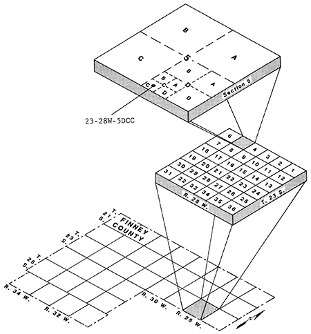
Well-numbering system
The well-numbering system, as shown in fig. 2, gives the location of a well or test hole according to the U.S. Bureau of Land Management's system of land subdivision. In this system, the first set of digits of a well number indicates the township; the second set, the range east or west of the Sixth Principal Meridian; and the third set, the section in which the well or test hole is located. The first letter after the section number denotes the quarter section or 160-acre tract; the second, the quarter-quarter section or 40-acre tract; and the third, the quarter-quarter-quarter section or 10-acre tract. The 160-, 40-, and 10-acre tracts are designated A, B, C, or D in a counterclockwise direction, beginning in the northeast quadrant. Multiple well or test-hole locations within a 10-acre tract are assigned consecutive numbers, beginning with "1," in the order in which data were collected. When only one well is present in a 10-acre tract, that "1" is frequently omitted. Thus, in Finney County, the number 23-28W-5DCC means that the well is in the SW SW SE sec. 5, T. 23 S., R. 28 W.
Figure 2--Well-numbering system.
Prev Page--Contents || Next Page--Geology
Kansas Geological Survey, Geohydrology
Placed on web June 14, 2013; originally published 1985.
Comments to webadmin@kgs.ku.edu
The URL for this page is http://www.kgs.ku.edu/Publications/Bulletins/IRR8/02_intro.html