Kansas Geological Survey, Ground-water Series 1, originally published in 1974
Consolidated rocks of Pennsylvanian age underlie all of Montgomery County and are exposed in most of the upland area. Sandstone beds in the Stranger Formation, Stanton Limestone, and Chanute Shale are the most important consolidated-rock aquifers. Locally, wells in the Stranger may yield as much as 20 gallons per minute, the Stanton yields as much as 15 gallons per minute to wells in the southwestern part of the county, and wells in the Chanute may yield as much as 50 gallons per minute. In parts of the county, suitable water for domestic and stock use is obtained from sandstone at depths of 200 to 400 feet. In other parts of the county, ground water may be moderately saline at depths of 50 feet or less.
Fluvial deposits of Quaternary age underlie flood plains and terraces along the stream valleys, and are an important source of ground water. These deposits yield as much as 100 gallons per minute to wells in the Verdigris River valley and from 5 to 50 gallons per minute in other major stream valleys. The water generally is very hard, but is suitable for domestic and stock use except in local areas where excessive concentrations of sulfate, sodium, and chloride are present.
Aquifers in many local areas have been contaminated by brine associated with oil and gas production and by improperly plugged drill holes. The major use of ground water is for domestic and stock supplies. All of the cities use treated surface water, and water districts obtain surface water to serve much of the rural population.
This report describes the geology and groundwater resources of Montgomery County, an area of 649 squares miles in southeastern Kansas (fig. 1). The investigation on which this report is based was part of a continuing program of ground-water investigations begun in 1937 by the Kansas Geological Survey and the U.S. Geological Survey, with support from the Division of Environmental Health of the Kansas State Department of Health and the Division of Water Resources of the Kansas State Board of Agriculture. The classification and nomenclature of the stratigraphic units used in this report (table 1) are those of the Kansas Geological Survey and differ somewhat from those of the U.S. Geological Survey.
Figure 1--Index map of Kansas showing area described in this report and areas covered by other online geologic reports, as of Sept. 2010. For additional information, please visit the KGS Geologic Maps of Kansas Page.
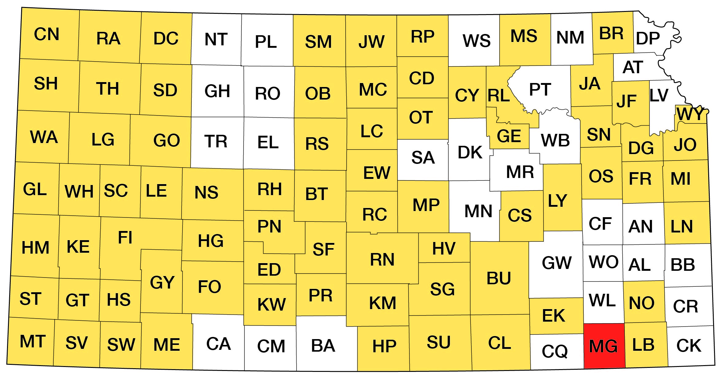
Table 1--Generalized columnar section and water-bearing characteristics.
| System | Series | Stage | Group | Formation, or rock unit |
Thickness, in feet |
Lithology | Water supply1 |
|---|---|---|---|---|---|---|---|
| Quaternary | Pleistocene | Alluvium | 0-60 | Unconsolidated clay, silt, sand, and gravel. Basal part contains 0 to 14 feet of sand and gravel. | Yields moderate supplies of water to wells in parts of the Verdigris River valley and in major tributary valleys. | ||
| Terrace deposits |
0-38 | Yields moderate supplies of water to wells in low terrace deposits. Intermediate and high terrace deposits yield lesser amounts to wells or may be above water table. | |||||
| Pennsylvanian | Upper Pennsylvanian | Virgilian | Douglas | Lawrence Formation |
140 | Chiefly olive-gray shale. As much as 30 feet of sandstone in upper part. Thin bed of Haskell Limestone Member at base. | Yields very small supplies of water to shallow wells in weathered zones. Sandstone beds generally above water table. |
| Stranger Formation |
100-175 | Gray shale and siltstone, and gray fine-grained sandstone. Thin bed of Westphalia Limestone Member in upper part. | Generally yields small to moderate supplies of water to wells in areas underlain by sandstone. Where sandstone beds are absent, yields very small to small supplies to shallow wells in weathered zone. | ||||
| Missourian | Lansing | Stanton Limestone |
70-130 | Consists of three limestone and two shale members. Limestones include fine-grained dense limestone, oolitic and sandy limestone, and fine-grained to coarsely crystalline limestone. Lower shale member locally includes a black fissile shale. Upper shale contains sandstone beds in outcrops in southern part of county. | Generally yields very small supplies of water to wells. Yields very small to small supplies of water to wells in areas underlain by thick limestone beds or shale. In southwestern part of county, yields very small to moderate supplies of water to wells in sandstone. | ||
| Vilas Shale | 50-120 | Chiefly medium-gray shale. | Generally yields little or no water to wells except in the shallow zone of weathering. | ||||
| Plattsburg Limestone |
0-70 | Thick gray fine-grained to crystalline limestone in northern part of county. Thin or absent south of Elk River. | |||||
| Kansas City | Bonner Springs Shale and Lane Shale |
85-150 | Gray silty to argillaceous shale. | ||||
| Iola Limestone |
2-10 | Consists of two limestones separated by a black fissile shale containing phosphatic concretions. Lower limestone locally sandy or may be absent. | Generally yields little or no water to wells except in the shallow zone of weathering. Yields small supplies to wells locally from black shale. | ||||
| Chanute Shale |
80-200 | Chiefly gray shale and fine-grained sandstone. The Noxie Sandstone Member occurs extensively in the lower part and the Cottage Grove Sandstone Member in the upper part. The middle part contains the Thayer coal bed, one to three thin limestones, and gray shale. | Widespread aquifer. Generally yields small to moderate supplies of water to wells from sandstone beds at depths of as much as 400 feet. | ||||
| Drum Limestone |
0-60 | Light-gray fine-grained limestone and light-gray crossbedded very fossiliferous oolitic limestone. | Generally yields little or no water to wells except in the shallow zone of weathering | ||||
| Cherryvale Shale |
0-90 | Chiefly bluish-gray shale with flagstones at top in outcrops in northern part of county. Flags increase in abundance southward. | |||||
| Dennis Limestone |
10-70 | Light-gray to bluish-gray limestone, locally sandy or oolitic in upper part. Gray shale and black fissile shale in lower part. Locally contains a 1- to 4-foot thick limestone at base. | In northeast area, yields very small to small supplies of water to wells at depths of as much as 200 feet. Elsewhere, generally yields little or no water except in the shallow zone of weathering. | ||||
| Coffeyville Formation |
200 | Chiefly medium-gray shale and siltstone. Upper part locally contains much fine-grained sandstone and several thin coals. Lower beds contain medium- to dark- gray and black shale. The Swope Limestone, 1 to 6 feet of gray limestone, occurs near the middle. | Generally yields little or no water to wells from the gray shales, siltstones, and thin limestones. Beds of sandstone and black shales locally yield small supplies of water to wells. | ||||
| Pleasanton | Checkerboard Limestone |
1-14 | Consists of two thin limestones separated by gray shale where thickest. Lower limestone is brown-weathering crossbedded coquina. | Generally yields little or no water to wells from the gray shales, siltstones, and thin limestones. Beds of sandstone and black shales locally yield small supplies of water to wells. | |||
| Seminole Formation |
5-10 | Chiefly medium- to dark-gray shale. Locally contains a thin fine-grained sandstone at base. | |||||
| Middle Pennsylvanian |
Desmoinesian | Marmaton | Holdenville Shale |
5-25 | Gray and bluish-green fossiliferous shale. | Generally yields little or no water to wells. | |
| Lenapah Limestone |
7-18 | Upper massive limestone and lower nodular bedded limestone separated by a thin gray shale. | Yields very small to small supplies of water to wells generally less than 50 feet deep. | ||||
| Nowata Shale | 3-30 | Medium- to light-gray shale, locally contains some fine-grained sandstone. | |||||
| Altamont Limestone |
15-20 | Upper and lower light-gray limestone members separated by gray and black fissile shale. | |||||
| Bandera Shale |
60-150 | Gray shale and sandstone. | |||||
| 1In this report, very small supplies refers to yields generally less than 1 gpm, small supplies to 1 to 5 gpm, and moderate supplies to 5 to 100 gpm. | |||||||
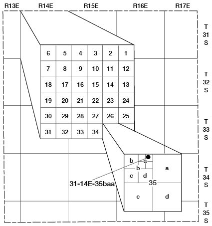
Well and test-hole numbers used in this report give locations according to the U.S. Bureau of Land Management system of land subdivision. The number is composed of township, range, and section numbers, followed by letters that indicate the subdivision of the section in which the well is located. The first letter denotes the quarter section, or 160-acre tract; the second letter denotes the quarter-quarter section, or 40-acre tract; and the third letter, when used, indicates the quarter-quarter-quarter section, or 10-acre tract. The 160-acre, 40-acre, and 10-acre tracts are designated a, b, c, and d in a counter-clockwise direction, beginning in the northeast quarter (fig. 2).
Figure 2--Well-numbering system used in this report.
Ground-water supplies in the consolidated rocks in parts of Montgomery County are inadequate or are of poor chemical quality for domestic and livestock use; however, in other parts of the county, sandstone aquifers yield as much as 50 gpm (gallons per minute) of good quality water to wells.
Sandstone beds in the Stranger Formation, Stanton Limestone, and Chanute Shale are the most important consolidated-rock aquifers (table 1). Locally, the Stranger Formation contains more than 100 feet of sandstone and siltstone, and well yields of as much as 20 gpm of hard but otherwise good quality water for domestic and stock use can be obtained (table 2). In the southwestern part of Montgomery County, as much as 40 feet of sandstone in the upper and middle parts of the Stanton yields 1/2 to 15 gpm of good to poor quality water to wells.
Table 2--Chemical analyses of water from selected wells, test holes, and springs. [Dissolved constituents and hardness given in milligrams per liter. Analyses by Kansas State Department of Health.]
| Well number |
Sample id number |
Depth of well below land surface (feet) |
Geologic source1 |
Date of collection |
Temp. (°C) |
Dissolved solids (residue at 180°C) |
Dissolved silica (SiO2) |
Total iron (Fe) |
Total manganese (Mn) |
Dissolved calcium (Ca) |
Dissolved magnesium (Mg) |
Sodium and potassium (Na+K) |
Bicarbonate (HCO3) |
Dissolved sulfate (SO4) |
Dissolved chloride (Cl) |
Dissolved fluoride (F) |
Dissolved nitrate (NO3) |
Hardness3 as CO3 |
Specific conductance (micromhos at 25°C) |
pH | |
|---|---|---|---|---|---|---|---|---|---|---|---|---|---|---|---|---|---|---|---|---|---|
| Calcium, magnesium |
Non- carbonate |
||||||||||||||||||||
| 31-15E-9bd | 1 | Spring | Stanton Ls | 5-2-1960 | 306 | 6.5 | 0.06 | 0.09 | 100 | 5.7 | 6.7 | 307 | 16 | 15 | 0.1 | 3.5 | 280 | 26 | 520 | ||
| 31-15E-26ba | 2 | 61 | Lane and Bonner Springs Sh |
6-2-1959 | 908 | 12 | .74 | .00 | 64 | 19 | 260 | 516 | 140 | 150 | 1.0 | 16 | 240 | 0 | 1,580 | ||
| 31-15E-32dd | 3 | 120 | Chanute Sh | 5-2-1960 | 1,730 | 10 | .52 | .07 | 55 | 15 | 610 | 448 | 20 | 800 | 2.0 | 2.4 | 200 | 0 | 3,250 | ||
| 31-16E-5bbb | 4 | 22 | Alluvium | 5-2-1960 | 1,250 | 12 | .22 | .12 | 210 | 54 | 110 | 359 | 450 | 65 | .2 | 170 | 740 | 450 | 1,890 | ||
| 31-16E-20dad | 5 | 25 | Terrace dep | 5-2-1960 | 530 | 14 | .09 | .00 | 110 | 20 | 42 | 276 | 170 | 10 | .3 | 26 | 350 | 130 | 825 | ||
| 31-16E-30ab | 6 | 105 | Chanute Sh | 5-5-1960 | 183 | 17 | .07 | .12 | 31 | 7.9 | 22 | 112 | 6.2 | 38 | .1 | 5.8 | 110 | 18 | 315 | ||
| 32-13E-26bb | 7 | 56 | Stranger Fm | 6-2-1959 | 287 | 14 | .14 | .00 | 66 | 13 | 11 | 163 | 86 | 8.0 | .1 | 8.0 | 220 | 84 | 455 | ||
| 32-13E-26bb | 8 | 56 | Stranger Fm | 5-14-1968 | 267 | 12 | .06 | .00 | 62 | 10 | 13 | 149 | 81 | 9.0 | .2 | 7.1 | 200 | 74 | 390 | 7.2 | |
| 32-14E-14cb | 9 | 28 | Alluvium | 5-5-1960 | 400 | 19 | .23 | .78 | 120 | 6.9 | 12 | 314 | 36 | 6.0 | .1 | 49 | 320 | 60 | 660 | ||
| 32-14E-23bab | 10 | Chanute(?) Sh | 5-14-1963 | 1,290 | 5.4 | 1.7 | .14 | 8.0 | 3.9 | 500 | 5442 | 53 | 420 | .6 | 1.5 | 36 | 0 | 2,140 | 8.9 | ||
| 32-15E-33abb | 11 | 80 | Chanute Sh | 4-24-1963 | 2,220 | 15 | .09 | .81 | 500 | 64 | 93 | 327 | 1,200 | 61 | .5 | 140 | 1,500 | 1,200 | 2,580 | ||
| 32-16E-7ab | 12 | 90 | Chanute Sh | 5-5-1960 | 311 | 25 | 9.1 | .27 | 31 | 11 | 57 | 143 | 48 | 40 | .2 | 28 | 120 | 5 | 515 | ||
| 32-16E-26dc | 13 | 168 | Coffeyville Fm | 4-25-1963 | 464 | 10 | .13 | .10 | 86 | 32 | 44 | 410 | 74 | 8.0 | .4 | 8.4 | 350 | 10 | 800 | ||
| 32-16E-29dd | 14 | 23 | Chanute Sh | 6-3-1959 | 1,170 | 12 | .38 | .35 | 150 | 52 | 150 | 207 | 630 | 62 | .3 | 11 | 600 | 420 | 1,700 | ||
| 32-17E-9bb | 15 | 79 | Cherryvale(?) Sh | 4-24-1963 | 574 | 10 | 3.8 | .10 | 110 | 25 | 57 | 346 | 160 | 37 | .1 | .4 | 390 | 100 | 940 | ||
| 32-17E-31dbb | 16 | 71 | Cherryvale(?) Sh | 4-24-1963 | 15.0 | 342 | 7.0 | 2.3 | .12 | 100 | 12 | 10 | 327 | 36 | 11 | .1 | .4 | 310 | 41 | 600 | |
| 33-13E-36ba | 17 | 140 | Stanton Ls | 6-3-1959 | 3,890 | 10 | .19 | .00 | 27 | 12 | 1,500 | 510 | 20 | 2,100 | 120 | 0 | 7,390 | ||||
| 33-13E-36ca | 18 | 25 | Stranger Fm | 6-3-1959 | 737 | 11 | .14 | .00 | 120 | 43 | 99 | 524 | 110 | 87 | .1 | 9.3 | 460 | 34 | 1,280 | ||
| 33-14E-14ab | 19 | 33 | Stanton Ls | 6-3-1959 | 14.5 | 246 | 6.0 | .08 | .00 | 59 | 11 | 7.4 | 129 | 77 | 6.0 | .2 | 16 | 190 | 86 | 425 | |
| 33-14E-14bb | 20 | 40 | Stanton Ls | 6-3-1959 | 932 | 13 | .03 | .00 | 180 | 37 | 72 | 316 | 400 | 51 | .3 | 23 | 610 | 350 | 1,400 | ||
| 33-14E-34ad | 21 | 80 | Stanton Ls | 6-3-1959 | 1,750 | 14 | .66 | .20 | 240 | 120 | 160 | 603 | 810 | 63 | .3 | 35 | 1,100 | 620 | 2,450 | ||
| 33-15E-8dc | 22 | 15 | Vilas and Lane Sh | 6-3-1959 | 2,920 | 7.0 | .16 | .00 | 500 | 140 | 280 | 256 | 1,100 | 730 | .4 | 53 | 1,800 | 1,600 | 4,500 | ||
| 33-15E-27cc | 23 | 74 | Chanute Sh | 4-25-1963 | 15.5 | 2,170 | 9.5 | 1.9 | .31 | 290 | 170 | 150 | 378 | 1,300 | 16 | .6 | 1.1 | 1,400 | 1,100 | 2,550 | |
| 33-16E-7bc | 24 | 125 | Chanute Sh | 6-3-1959 | 3,690 | 24 | .30 | .00 | 520 | 240 | 280 | 464 | 2,200 | 91 | .5 | 71 | 2,300 | 1,900 | 4,240 | ||
| 33-16E-7dc | 25 | 44 | Chanute Sh | 5-2-1960 | 14.0 | 474 | 11 | 3.9 | .92 | 68 | 33 | 44 | 217 | 200 | 11 | .3 | 4.4 | 300 | 130 | 750 | |
| 33-16E-20bb | 26 | 90 | Chanute Sh | 6-3-1959 | 838 | 17 | 3.9 | .46 | 100 | 56 | 140 | 664 | 66 | 130 | .1 | 1.3 | 490 | 0 | 1,490 | ||
| 33-16E-30bc | 27 | 175 | Chanute Sh | 6-3-1959 | 15.5 | 680 | 14 | 3.8 | .00 | 41 | 21 | 170 | 376 | 230 | 12 | .4 | 1.8 | 190 | 0 | 1,100 | |
| 33-16E-32bd | 28 | 59 | Chanute Sh | 5-3-1960 | 175 | 25 | .14 | .00 | 31 | 7.4 | 12 | 107 | 12 | 9.0 | .1 | 26 | 110 | 20 | 255 | ||
| 33-17E-15cd | 29 | 20 | Coffeyville Fm | 4-25-1963 | 2,880 | 9.0 | .13 | .11 | 230 | 180 | 410 | 412 | 1,600 | 77 | .7 | 190 | 1,300 | 990 | 3,550 | ||
| 34-13E-13ba | 30 | 140 | Stanton Ls | 6-3-1959 | 3,590 | 7.0 | .22 | .00 | 40 | 17 | 1,400 | 466 | 28 | 1,900 | 1.9 | 2.0 | 170 | 0 | 6,880 | ||
| 34-14E-11ddd | 31 | 85 | Stanton Ls | 5-4-1960 | 1,300 | 10 | .07 | .00 | 230 | 45 | 140 | 386 | 550 | 91 | .5 | 53 | 760 | 440 | 1,920 | ||
| 34-14E-12dd | 32 | Spring | Stanton Ls | 6-3-1959 | 15.0 | 221 | 6.0 | .03 | .00 | 64 | 6.9 | 8.3 | 207 | 14 | 9.0 | .1 | 11 | 190 | 18 | 410 | |
| 34-14E-16ab | 33 | 65 | Stanton Ls | 4-24-1963 | 3,740 | 12 | 23 | .48 | 500 | 340 | 180 | 527 | 2,400 | 49 | .7 | 1.1 | 2,600 | 2,200 | 4,010 | ||
| 34-14E-25da | 34 | 74 | Stanton Ls | 4-25-1963 | 529 | 12 | .05 | .10 | 100 | 38 | 38 | 390 | 120 | 25 | .2 | 1.9 | 410 | 90 | 860 | ||
| 34-14E-36dd | 35 | 175 | Chanute Sh | 5-4-1960 | 786 | 11 | .08 | .00 | 24 | 7.3 | 270 | 413 | 120 | 120 | 1.6 | 3.4 | 90 | 0 | 1,320 | ||
| 34-15E-15cb | 36 | 65 | Chanute Sh | 6-3-1959 | 204 | 22 | .66 | .00 | 39 | 6.5 | 16 | 124 | 4.1 | 13 | .1 | 42 | 120 | 22 | 335 | ||
| 34-15E-25da | 37 | 30 | Chanute Sh | 5-3-1960 | 15.0 | 1,690 | 16 | .80 | 3.2 | 250 | 49 | 300 | 702 | 420 | 310 | .3 | 4.1 | 820 | 240 | 2,620 | |
| 34-15E-26da | 38 | 40 | Chanute Sh | 5-3-1960 | 302 | 25 | .26 | .11 | 53 | 11 | 32 | 184 | 42 | 21 | .1 | 27 | 180 | 25 | 505 | ||
| 34-16E-16aa | 39 | 65 | Chanute Sh | 5-3-1960 | 224 | 19 | .08 | .08 | 36 | 9.3 | 22 | 116 | 56 | 6.0 | .1 | 19 | 130 | 34 | 360 | ||
| 34-16E-16dc | 40 | Spring | Chanute Sh | 5-3-1960 | 13.0 | 139 | 18 | .04 | .00 | 27 | 5.0 | 11 | 101 | 14 | 4.0 | .1 | 10 | 88 | 5 | 220 | |
| 34-16E-17ab | 41 | 50 | Chanute Sh | 5-3-1960 | 15.0 | 261 | 16 | .21 | .00 | 48 | 23 | 17 | 278 | 9.1 | 7.0 | .6 | 3.6 | 210 | 0 | 445 | |
| 34-16E-30bc | 42 | 29 | Chanute Sh | 5-3-1960 | 486 | 7.5 | .07 | .00 | 110 | 23 | 20 | 273 | 91 | 43 | .1 | 53 | 380 | 160 | 860 | ||
| 34-17E-15cc | 43 | 31 | Coffeyville(?) Fm | 4-25-1963 | 14.5 | 7,160 | 9.5 | .11 | .10 | 520 | 850 | 480 | 504 | 4,400 | 510 | 1.1 | 170 | 4,800 | 4,400 | 7,350 | |
| 34-17E-19cd | 44 | Spring | Terrace dep | 5-4-1960 | 15.0 | 499 | 13 | .06 | .00 | 120 | 15 | 31 | 311 | 86 | 53 | .2 | 24 | 370 | 120 | 880 | |
| 34-17E-28bb | 45 | 32 | Checkerboard Ls and Seminole(?) Fm |
5-4-1960 | 1,210 | 17 | 1.0 | .00 | 180 | 52 | 170 | 334 | 400 | 230 | .4 | 2.1 | 650 | 380 | 1,920 | ||
| 34-17E-34aa | 46 | 23 | Altamont Ls | 4-25-1963 | 13.5 | 1,110 | 9.0 | .05 | .00 | 210 | 53 | 69 | 284 | 310 | 140 | .1 | 180 | 750 | 520 | 1,690 | |
| 35-14E-1ab | 47 | 190 | Chanute Sh | 5-4-1960 | 644 | 8.0 | .39 | .12 | 110 | 20 | 82 | 190 | 160 | 120 | .1 | 43 | 360 | 200 | 1,120 | ||
| 35-14E-6dcc | 48 | 59 | Stanton Ls | 5-4-1960 | 14.5 | 1,210 | 13 | .12 | .12 | 87 | 53 | 270 | 539 | 440 | 81 | 1.7 | 5.8 | 440 | 0 | 1,850 | |
| 35-14E-9dd | 49 | 265 | Chanute Sh | 5-4-1960 | 18.0 | 1,550 | 12 | 6.3 | .38 | 20 | 9.3 | 580 | 573 | 35 | 600 | 2.2 | 8.0 | 88 | 0 | 2,750 | |
| 35-14E-16dba | 50 | 255 | Chanute Sh | 5-4-1960 | 1,780 | 8.5 | .09 | .00 | 5.8 | 7.2 | 710 | 832 | .0 | 630 | 4.6 | 2.8 | 44 | 0 | 3,250 | ||
| 35-15E-1add | 51 | 35 | Chanute Sh | 6-3-1959 | 14.5 | 361 | 12 | .17 | .00 | 94 | 12 | 17 | 261 | 54 | 27 | .1 | 16 | 280 | 70 | 650 | |
| 35-15E-2ba | 52 | 151 | Chanute Sh | 6-3-1959 | 16.0 | 533 | 20 | .78 | .10 | 81 | 34 | 59 | 354 | 140 | 24 | .2 | 2.1 | 340 | 52 | 900 | |
| 35-16E-6ba | 53 | 35 | Chanute Sh | 5-3-1960 | 269 | 8.5 | .07 | .10 | 76 | 9.4 | 11 | 256 | 29 | 7.0 | .1 | 2.5 | 230 | 19 | 465 | ||
| 35-17E-10ba | 54 | Spring | Lenapah Ls | 4-25-1963 | 305 | 7.5 | .06 | .06 | 93 | 7.8 | 13 | 296 | 21 | 12 | .4 | 5.3 | 260 | 22 | 530 | ||
| Kansas State Board of Health (1973) recommended maximum concentration for drinking water |
500 | .3 | .05 | 250 | 250 | 1.5 | 45 | ||||||||||||||
| 1 dep, deposits; Fm, Formation; Ls, Limestone; Sh, Shale. 2 Includes 46 mg/l carbonate. 3 The classification for hardness used in this report is as follows: 0-60, soft; 61-120, moderately hard; 121-180, hard; more than 180, very hard. |
|||||||||||||||||||||
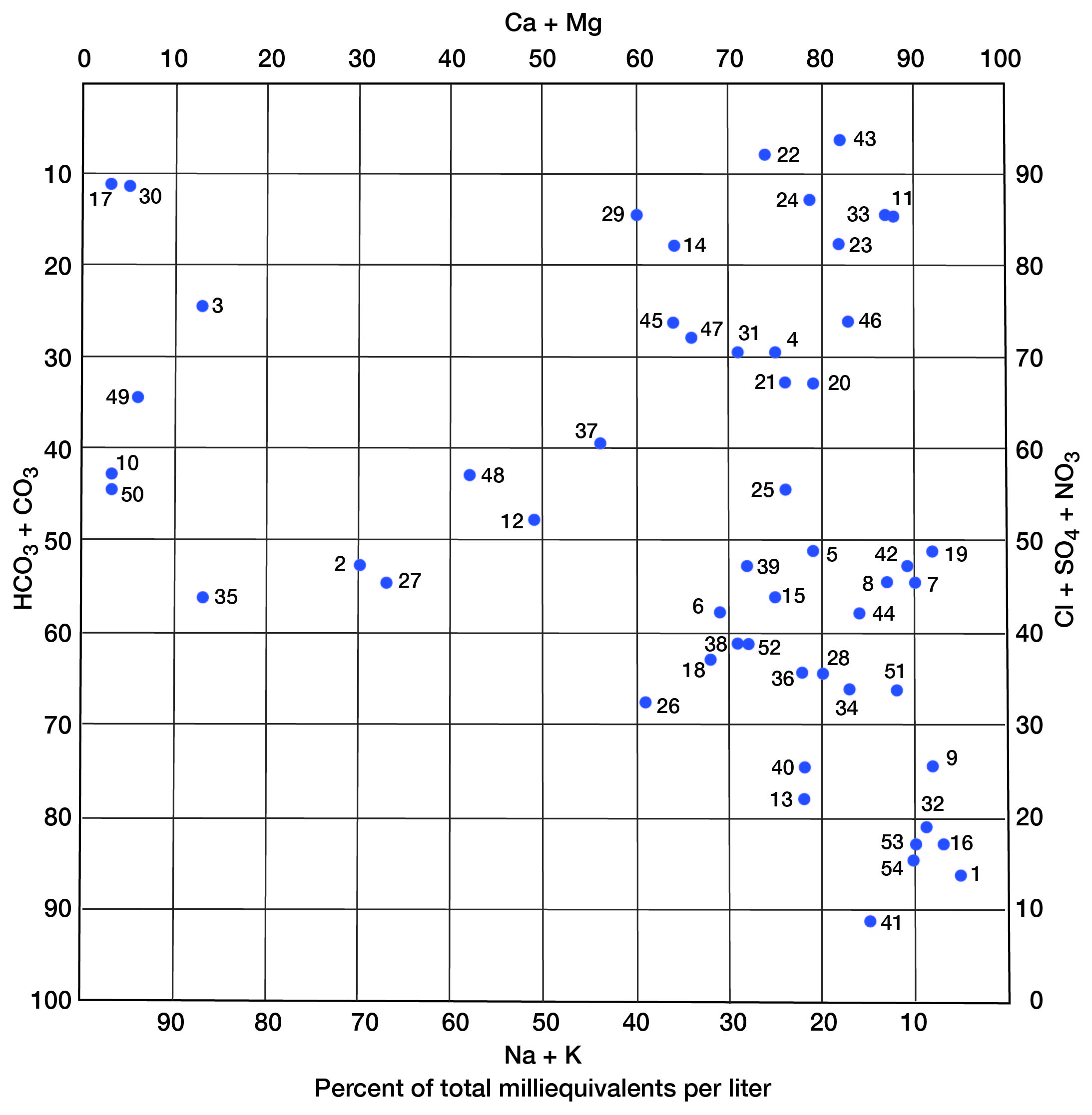
The Chanute Shale ranges in thickness from about 80 feet in the northern part of Montgomery County to about 200 feet in the southern part. It contains two extensive sandstone members-the Cottage Grove in the upper part and the Noxie in the lower part. Well yields range from less than 1 gpm to as much as 50 gpm. The chemical quality of water supplies obtained from these sandstones ranges from good to poor for stock and domestic use. Some wells in the Cottage Grove Member and the Noxie Member obtain very hard water of the calcium and magnesium sulfate type, whereas other wells obtain much softer water having sodium chloride and sodium bicarbonate as the principal constituents (fig. 3). About one-fourth of the water samples collected from wells and springs obtaining water from the Chanute have dissolved-solids concentrations of less than 300 mg/l (milligrams per liter); this water generally is of good quality for stock and domestic use.
Figure 3--Modified Piper diagram showing grouping of analyses of water from wells. Numbers by symbols are sample-identification numbers from table 2.
A few wells obtain water from sandstone beds in the Coffeyville and Seminole Formations in eastern Montgomery County. Locally, water from the Coffeyville, even at shallow depths, may be of poor quality and unsuitable for domestic or stock use because of large concentrations of sulfate (table 2). No wells were inventoried that obtained water supplies from sandstones in the Nowata or Bandera Shales, although small water supplies might be obtainable from these units east of the Verdigris River and south of Claymore Creek in southeastern Montgomery County.
Most limestone units at shallow depths in Montgomery County will yield small supplies of ground water to large-diameter wells in the zone of weathering during periods of normal or above normal precipitation. The thick limestone reefs or banks of the Stanton and Plattsburg Limestones in northwestern Montgomery County and the Drum Limestone in the Independence area are unreliable sources of water for wells. A few wells obtain domestic and stock water supplies at depths of 200 feet or less from the Dennis Limestone in the northern part of T.31 S., R.17 E. Limestone aquifers generally yield hard to very hard water of the calcium bicarbonate type. Locally, the concentration of sulfate may be excessive for domestic use.
The shale units in Montgomery County generally yield little water to wells. Shallow large-diameter wells constructed in weathered shale may yield 100 to 1,000 gallons per day, but may be dry part of the time. Black or dark-gray shales commonly contain plant and other carbonaceous material and associated iron sulfides. Water from shallow wells in these shales may be very hard and contain so much sulfate that it is not suitable for either domestic or stock use.
The deepest known fresh (less than 1,000 mg/l dissolved solids) to slightly saline (1,000 to 3,000 mg/l dissolved solids) water supplies in the county are from sandstone in the Chanute Shale in the southwestern part of the county at depths of 200 to 400 feet below land surface, and from the Dennis Limestone and Coffeyville Formation in the northeastern part at depths of 100 to about 250 feet. Locally, in southeastern Montgomery County, ground water at depths of less than 50 feet is moderately saline (3,000 to 10,000 mg/l dissolved solids). Oil has been reported at depths of less than 50 feet in the vicinity of Coffeyville, and the water associated with the oil is not suitable for domestic use. Throughout the county, rocks older than the Bandera Shale yield saline water having dissolved-solids concentrations greater than 3,000 mg/l. These rocks commonly contain water having 10,000 to 200,000 mg/l dissolved solids. Although shallow consolidated-rock aquifers may contain large concentrations of sulfate locally, the chloride concentration is normally low.
Aquifers in many local areas have been contaminated by brine associated with oil and gas production and by improperly plugged abandoned drill holes. In these areas, the contamination of fresh ground water is indicated by the increased amounts of sodium chloride in relation to other constituents. Most of the more than 11,000 holes drilled for oil and gas in Montgomery County were drilled prior to the enactment of legislation in 1934 regulating the drilling, casing, and plugging of wells and the disposal of produced brine to protect the fresh and usable water resources. Improperly plugged wells in local areas are a continuing source of contamination.
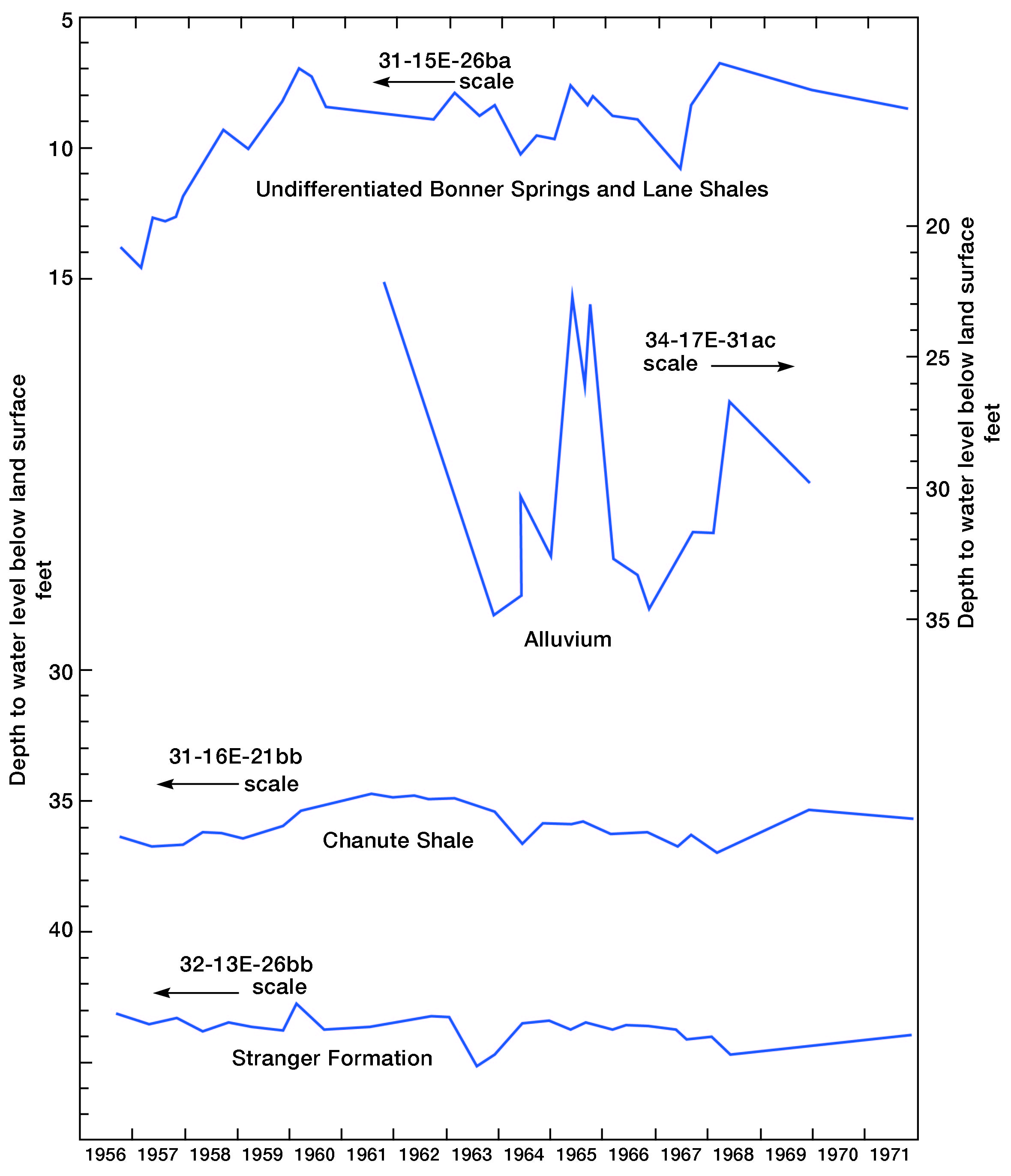
Water levels in the consolidated-rock aquifers fluctuate in response to natural discharge and recharge of water and to pumping by wells. Hydrographs for three wells tapping consolidated-rock aquifers are shown on figure 4. Fluctuations of water levels in wells tapping consolidated-rock aquifers in highly dissected topography, such as along a bluff of a stream valley, or in wells tapping aquifers of poor water-yielding characteristics, such as some of the shale units, generally are relatively large. Fluctuations of water levels in wells tapping the better aquifers, or aquifers that are not highly dissected, generally are small.
Figure 4--Hydrographs for four consolidated wells.
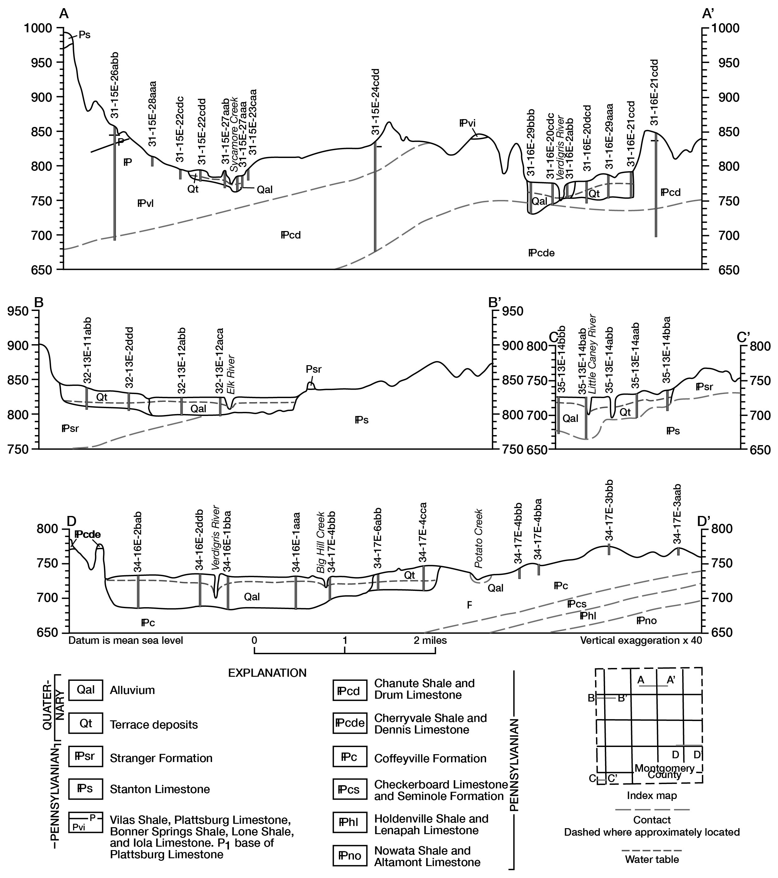
Fluvial deposits of clay, silt, sand, and gravel, which form and underlie the flood plains and low terraces of stream valleys, are important sources of ground water. Information obtained from wells and test holes (geohydrologic map) indicates that the thickness of alluvium commonly ranges from about 10 to 60 feet. Four geologic sections (fig. 5) illustrate the range in thickness of the alluvium and the low-terrace deposits, show the position of the water table and the thickness of saturated deposits, and indicate that the water table slopes toward the streams and that ground water is discharged to the streams. During high stages of the streams, when surface water is above the level of the adjacent water table, water in streams infiltrates and recharges the aquifer. Yields of wells in the alluvium and low-terrace deposits may be as much as 100 gpm in the Verdigris River valley, and may range from 5 to 50 gpm in other major stream valleys.
Figure 5--Geologic sections. Traces of the sections are also shown on the geohydrologic map. [This figure is also available as an Acrobat PDF file (432 kb).]
The chemical quality of water from the alluvium and low-terrace deposits ranges from good to poor for domestic and stock use. These aquifers generally yield very hard water of the calcium bicarbonate type that is low in concentrations of chloride, but locally may contain appreciable concentrations of sulfate. In some areas, however, high concentrations of sodium and chloride result from contamination associated with past oil and gas exploration and production.
Water levels in test holes in the alluvium ranged from about 3 to 22 feet below land surface in 1961. A water-level fluctuation of 13 feet during 1961-69 is shown by the hydrograph for observation well 34-17E-31ac in the alluvium near Coffeyville (fig. 4). Water-level changes of 20 feet or more in areas not affected by pumping probably should be expected in the alluvium of the Verdigris River valley during a cycle of wet and dry years.
The older fluvial deposits that occur as dissected and discontinuous terraces 20 to 100 feet above the flood plain may contain a thin saturated section or may be above the water table.
The largest development of ground water in the county is for livestock and domestic use. In some areas, aquifers have only very small supplies of ground water or have hard water of poor quality. In other areas, aquifers have been contaminated by brine as a result of improper drilling, casing, and plugging of oil and gas wells and the improper handling of brines in the early years of oil and gas exploration. Since 1960, therefore, an effort has been made to expand rural water-distribution systems using water purchased from larger cities; all cities in Montgomery County utilize treated surface water for their water supplies. The trend toward public-water supplies to serve rural areas probably will continue even though some areas served by rural water districts have ground-water supplies of good quality.
No irrigation developments utilize ground water and only a few industries have developed small ground-water supplies. Some ground water from shallow wells is used in oil-field secondary recovery projects.
Abernathy, G. E., 1940, Oil and gas in Montgomery County, Kansas: Kansas Geol. Survey Bull. 31, 29 p.
Goebel, E. D., 1962, The occurrence of oil and gas in Wilson and Montgomery Counties, Kansas: Kansas Geol. Society, 27th Field Conf. Guidebook, p. 134-137.
Harbaugh, J. W., 1962, Geologic guide to Pennsylvanian marine banks, southeast Kansas: Kansas Geol. Society, 27th Field Conf. Guidebook, p. 13-67.
Hem, J. D., 1970, Study and interpretation of the chemical characteristics of natural water: U.S. Geol. Survey Water-Supply Paper 1473, 2d ed., 363 p.
Kansas State Board of Health, 1973, Water quality criteria for interstate and intrastate waters of Kansas: Kansas State Board of Health Regulations 28-16-28, 5 p.
Kansas Water Resources Board, 1960, Preliminary appraisal of Kansas water problems, sec. 5, Walnut-Verdigris Unit: Kansas Water Resources Board, State Water Plan Studies, pt. A, 160 p.
Latta, B. F., 1963, Fresh water pollution hazards related to the petroleum industry in Kansas: Kansas Acad. Sci. Trans., v. 66, no. 1, p. 25-33.
O'Connor, H. G., 1962, A summary of the geology of Montgomery County, Kansas: Kansas Geol. Society, 27th Field Conf. Guidebook, p. 149-158.
Schrader, F. C., 1908, Independence folio, Kansas: U.S. Geol. Survey Geol. Atlas, Folio 159, 17 p.
Kansas Geological Survey, Montgomery County, Kansas
Placed on web Sept. 7, 2010; originally published in Sept. 1974.
Comments to webadmin@kgs.ku.edu
The URL for this page is http://www.kgs.ku.edu/Publications/Bulletins/GW1/index.html