![]()
![]()
![]()
Prev--Equability in the late Pleistocene
|
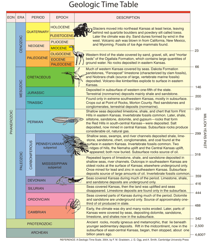
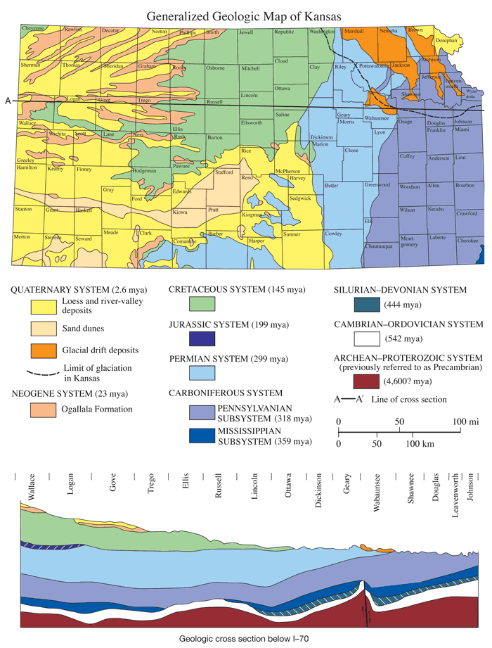
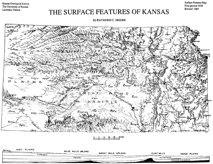
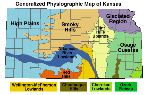
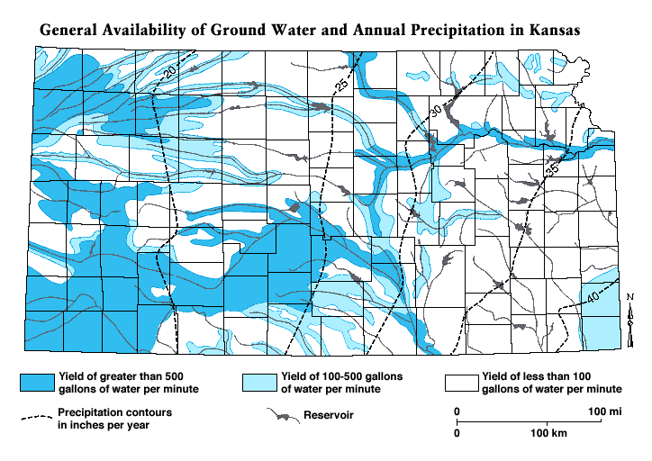
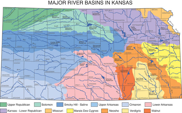
Kansas is part of the Great Plains country that extends for thousands of miles north and south along the east side of the Rocky Mountains. This plain is not flat and featureless. On the contrary, there are innumerable hills and picturesque valleys. In some places the surface of the land slopes steeply, or even precipitously, and local differences in elevation may exceed 400 feet. In parts of western and southwestern Kansas, there are small canyons with steep bare rock walls that call to mind parts of Wyoming or Arizona. As a whole, the land surface of Kansas slopes eastward from a maximum elevation of 4,135 feet in Wallace County, adjoining the Colorado line, to the lowest point about 700 feet where Verdigris River crosses the Oklahoma boundary from Montgomery County. As shown by the accompanying map there are several natural topographic divisions in Kansas, each distinguished by certain peculiarities of land form, which in turn are explainable for the most part by the nature of the rock formations at the surface in these areas. The eastern one-third of the state--that is the country east of a north-south line drawn approximately through Wichita and Abilene, belongs in what has been called the Osage Plains. They are distinguished by the presence of many east-facing escarpments which trend very irregularly from north to south across the state. The escarpments range in height from 50 feet or less to more than 400 feet, the most prominent being the so-called Flint Hills which are very well seen near Manhattan, Cottonwood Falls, west of Eureka and elsewhere. The escarpments are made by the edges of hard limestones which slope gently westward. Between the escarpments are flat or gently rolling plains formed by the softer rocks of this region. The Smoky Hills Upland in the north-central part of the state owes its origin to exposure of moderately hard thick brown sandstone, the Dakota. This formation also forms an east-facing escarpment, but it is somewhat less regular than the limestones and there are numerous outlying hills. The Blue Hills Upland, a short distance to the west, is produced by hard limestone in the Cretaceous. Here there are many long spurs running eastward forming the divides between the east-flowing streams. South of the Blue and Smoky hills is a large area of nearly flat land which may be called the Great Bend Prairie. It comprises mainly the country embraced by the great bend of the Arkansas River between Dodge City and Wichita, but also the nearly flat region northeast of the river around McPherson and Newton. Parts of this region are very sandy and are covered by many sand dunes or by small hummocky hills that were once sand dunes. South of the Great Bend Prairie are the Cimarron Breaks, in which the higher country to the north and west is suddenly interrupted by a prominent escarpment carved by steep south ward-flowing streams, tributaries mostly of the Cimarron and Medicine Lodge. Much of the rock in this area is red shale or fine red sandstone, and accordingly both rock exposures and soils are colored red. The remaining part of Kansas, constituting approximately the western one-third, is called the High Plains. The land surface rises very gradually westward to the flanks of the Rockies in central Colorado where it is more than a mile above sea level. In northwestern Kansas, the High Plains have been carved by east- and northeast-flowing streams so as to form long and fairly prominent uplands between the streams with innumerable rounded hills formed by the tributary smaller drainage. In central western and southwestern Kansas, on the other hand, the country is almost undissected. Low bluffs border the Arkansas on the north and in part on the south. East of Lakin there is a belt of prominent sand hills on the south side of the river. All of the larger stream valleys are flat-floored and only slightly above the level of the water in the streams. The width varies from less than a mile to as much as four to five miles, depending on the size of the stream and the hardness of the rocks in which the valley is carved. The fertile alluvial soil of these valleys furnishes excellent farm land, and the valleys are natural routes for highways and railroads. |
Prev--Equability in the late Pleistocene
Kansas Geological Survey
Comments to webadmin@kgs.ku.edu
Web version updated March 27, 2010. Original publication date 1987.
URL=http://www.kgs.ku.edu/Publications/Bulletins/GB5/appendices.html