Kansas Geological Survey, Chemical Quality Series 4, originally published in 1977
Next Page--Appendix
Originally published in 1977 as Kansas Geological Survey Chemical Quality Series 4. This publication is also available as an Acrobat PDF file (2 MB).
The utilization of irrigation waters in Kansas has increased dramatically since the drought period of the 1950's. With this development has come the need for information which can be used in the determination of compatibility of groundwaters with soils and crops and in the management of the groundwater systems tapped for agricultural purposes. An important component of this information is the chemical character of the waters under consideration.
The chemical quality data contained in this report show that groundwater presently in use from the Arkansas River valley in Kearny, Hamilton, and Finney counties and a band north of the river in Finney County is of sufficiently poor quality that it could produce adverse effects upon soils and crop yields with uncontrolled long-term usage. In most cases, poorer quality groundwater is associated with the presence of saline soils and shallow water tables.
Further efforts in this study are being directed toward correlating the chemistry of the groundwaters with natural variables such as soil association, bedrock types, depth to water, and surface and bedrock topography, and using these correlations to produce areal presentations of the chemical quality data. With these correlations and more complete coverage of western Kansas, positive policy recommendations concerning the conservation and proper use of the groundwater supplies of the state will be possible. This series of studies was begun on a limited scale in 1974 with that goal in mind. Greeley, Wichita, Scott, Lane, and southern Wallace counties were covered in that year; the results were reported in Kansas Geological Survey Chemical Quality Series 2. This report covers work done in 1975. In 1976, the rest of the southwest portion of the state was sampled; a report on that area is in preparation. This summer the Great Bend Prairie area will be sampled.
One-hundred-ninety-nine pumping irrigation wells were sampled in Hamilton, Kearny, Finney, and northern Gray counties and adjoining portions of Wichita, Scott, Grant, Stanton, and Haskell counties during late July 1975. Saline water of a SO4 type is found in the western three-fourths of the Arkansas River valley and a zone north of the river in Finney County. A better quality water of a Ca-HCO3 type exists in the sandy regions south of the river. Localized variations exist in the Scott-Finney Depression area.
Compiled chemical quality data and chemical quality maps are presented for the study area.
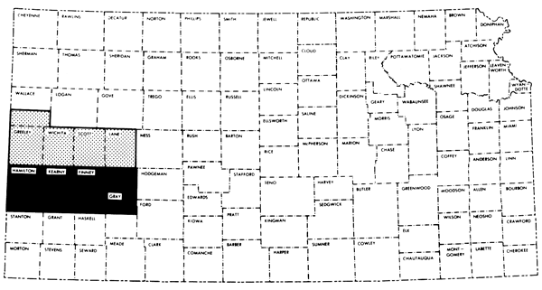
A program to establish chemical quality base-line data for irrigation waters of the Central High Plains region of western Kansas was initiated in the west-central Kansas area in 1974 (Hathaway et al., 1975). The present 3 1/2 county study area lies immediately south of the west-central region, and represents the upper portion of the southwestern Kansas region of groundwater studies (Figure 1).
Figure 1--Index map of Kansas showing area covered by this report (shaded area). The region covered by the 1974 west-central Kansas chemical quality study is shown also (solid area).
Irrigation waters in the present study are derived mainly from the Ogallala Formation of Pliocene age or undifferentiated Quaternary-Tertiary sequences. Alluvium associated with the Arkansas River valley, which trends in a southeastward direction through the study area, also serves as an aquifer for wells located in that valley.
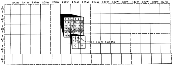
Well locations given in this report are based upon the Bureau of Land Management numbering system. The location is composed of the township, the range, and the section number followed by letters denoting the subdivision of the section on which the well is located (Figure 2).
Figure 2--Well location system used in this report.
The general topography of southwestern Kansas has been described by H.T.U. Smith (1941). The area covered by this report is characterized by a plains type topography. A general west to east slope of the land surface is noted for the study area. The Arkansas River is the major stream in this region and has a course which trends in a southeastward direction through the area covered by this report.
North of the Arkansas River at Garden City the plains are divided by the Scott-Finney depression which is a broad shallow depression extending northward to the Scott Basin. Little surface drainage occurs from this depression into the Arkansas River, and numerous smaller depressions are found upon the floor of this feature. The Pawnee River, located in the northeastern portion of the study area, joins the Arkansas River at some distance to the east of the region under investigation.
The consolidated rocks of Cretaceous age underlying the unconsolidated deposits of Tertiary and Quaternary age serve as bedrock in the study area. Figure 3 shows that a general increase in age of the bedrock formations occurs in passing from north to south through much of the study area, i.e., Niobrara Formation to Carlile Shale to Greenhorn Limestone to Graneros Shale to undifferentiated lower Cretaceous--which includes the Cheyenne Sandstone, the Kiowa Shale, and the Dakota Formation (H.E. McGovern and W.A. Long, 1974; E.D. Gutentag et al., 1972; D.H. Lohmeyer and C.G. Sauer, 1974; E.D. Gutentag, D.H. Lohmeyer and H.E. McGovern, 1972). This general trend is partially altered in southwest Hamilton County, presumably as a result of deep erosion by the ancestral Arkansas River and movement along the Bear Creek fault (D.H. Lohmeyer and C.G. Sauer, 1974).
Figure 3--Bedrock geology of the study area.
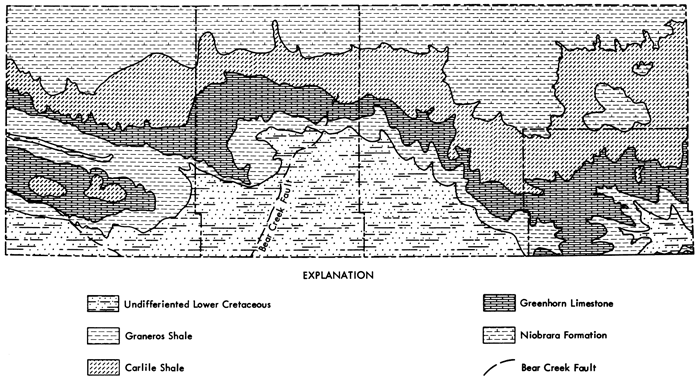
Figure 4 represents a general soil map for the study area which has been produced through a combination of the individual county general soil maps (Harner et al., 1965; Tomasu and Roth, 1968; McBee et al., 1961; Sallee et al., 1963). The continuity needed for the regional general soil map necessitated a certain amount of grouping of the various soil associations presented on the county general soil maps, or in some cases a regrouping of mapping units was needed to reflect the proportional pattern of soils in natural landscapes on a multi-county basis. The soil associations used on this regional map are listed in Table 1 along with a general description and the typical locations of these soil associations.
Figure 4--Soil association map of the study area. Saline conditions are generally associated with the Ulysses (saline)-Church-Drummond and Las-Bridgeport-Las Animas groups in the study area.
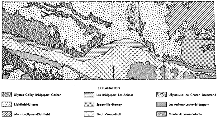
Table 1--Soil Associations for Hamilton, Kearny, Finney, and Northern Gray Counties.
| Soil Association | Description |
|---|---|
| Tivoli-Vona-Pratt | These sandy soils are found on undulating and hilly landscapes. The dominant area of occurrence for these soils is south of the Arkansas River valley. They are also found locally in patches on the eastern edge of the Scott-Finney depression. Little or no runoff occurs from these areas to stream systems. |
| Manter-Ulysses-Satanta | Loamy soils occurring on nearly level and gently undulating landscapes. The dominant region is a transitional band between the sandhills and the silty loess areas south of the Arkansas River valley. Small areas also exist along the eastern edge of the Scott-Finney depression. Little or no runoff occurs from these areas to stream systems. |
| Ulysses-Colby-Bridgeport-Goshen | Most of this association consists of silty and loamy soils on nearly level to strongly sloping landscapes. These soils occur mainly in the western half of the study area along upland drainage-ways and on the north wall of the Arkansas River valley. |
| Las-Bridgeport-Las Animas | These loamy, sandy, and silty soils are on nearly level to gently undulating landscapes. These soils occupy the Arkansas River valley to about the Gray county line in the study area. Soils in the lower valley positions are slightly to moderately saline. |
| Richfield-Ulysses | These silty soils are on broad, nearly level landscapes. This is the dominant soil association of the uplands. Little or no runoff occurs from these areas to stream systems. |
| Spearville-Harney | These clayey and silty soils are located on broad, nearly level landscapes in the eastern one-fourth of the study area. |
| Mansic-Ulysses-Richfield | Loamy and silty soils occurring on nearly level to strongly sloping landscapes. Found in the eastern one-fourth of the study area along upland drainage ways and the north wall of the Arkansas River valley. |
| Ulysses (saline)-Church-Drummond | Silty and clayey soils found on nearly level landscapes. They are slightly to highly saline, and are found in the Scott-Finney depression. |
| Las Animas-Lesho-Bridgeport | These loamy, sandy, and silty soils are on nearly level to gently undulating landscapes. These soils occur in the Arkansas River valley through most of Gray County. The soils in the lower valley positions tend to be slightly to moderately saline. |
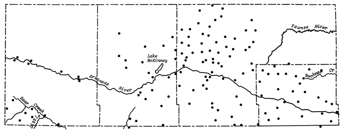
Groundwater samples were collected from 199 pumping wells over a four-day period during the high production portion of the season, July 28-31, 1975. Sampling procedures and field determinations were the same as those described for the west-central Kansas study. Historical chemical quality data was found to exist for about 14% of the wells sampled in this study. Duplicate sets of samples were collected at 15 sites distributed across the study area. These wells were located along the boundaries of individual field personnel sampling areas and thus each duplicate set represents different samplings of the same well by two people. The time interval between collection of the pair of samples at these duplicate sites ranged from the same day to two days.
Figure 5 indicates the locations of the wells sampled in this study. Wells were sampled in township 27 of Stanton, Grant, and Haskell counties and townships 19-21 of Wichita and Scott counties to provide greater control at the boundaries of the main 3 1/2 county study area during mapping of the chemical quality data. Analytical data for these control wells are listed in the compilation of chemical quality data of Appendix A, but are not included in the mapped areas of the chemical quality maps. The distribution of wells sampled for this study follows closely the regions shown as having pumping potentials of 100-500 gal./ min. or greater on Map M-4A--General Availability of Ground Water and Normal Annual Precipitation in Kansas (C.K. Bayne et al., 1975).
Figure 5--Distribution of irrigation wells sampled during study. Principal drainage systems in the area are also indicated.
Analytical procedures for all species except the trace elements iron (Fe) and manganese (Mn) were the same as described in the west-central Kansas report. The specific conductance and pH were measured at the time of collection. A field laboratory was established at Garden City and bicarbonate (HCO3), chloride (Cl), and fluoride (F) analyses were performed there. All other chemical determinations were made at the Kansas Geological Survey laboratories in Lawrence. Iron, manganese, nickel (Ni), and copper (Cu) were determined by atomic absorption spectroscopy using flameless atomization via a graphite furnace. Preconcentration of these elements and removal from interfering salts was achieved through the use of ammonium pyrrolidine dithiocarbamate as a complexing agent and methylisobutyl ketone as an extraction solvent. The major advantages of this procedure over that used in the west-central Kansas study are lower detection limits, reduced influence of dissolved solids, and smaller volumes of samples necessary for analysis.
A variation of about 9% in the reported specific conductance values was obtained for the sets of duplicate samples. Variations in the analytical data for the major chemical species from these same sets average about 4%. The greater fluctuation noted in the specific conductance values probably results from variations in field equipment used and operator technique. Standard deviations for replicate determinations of a given sample are comparable to those listed in the west-central Kansas study.
Compiled chemical quality data for groundwater samples taken during this study are listed in the Appendix by county and location.
Significant correlations are found to exist between the major chemical species of the groundwaters and areal parameters such as soil association, depth to water, bedrock and surface topographies, and bedrock type. The study area is divided roughly into three parts based upon these correlations: 1) area north of the Arkansas River, 2) Arkansas River valley, and 3) area south of the Arkansas River. These distinctions, however, become less clear in the eastern portion of the study area.
Due to the complexity of the study area and concentration distributions of the various chemical species, the simple computerized plotting routine used in the west-central Kansas chemical quality study was found to be inadequate for mapping the present study area. Chemical quality maps presented in this report were plotted manually using the soil associations as the principal guide. Mapping was cut off along the <100 gal/min boundary of the water quantity map M-4A. Work is currently underway to develop methods for using the correlation relationships between areal parameters and observed concentrations of the various chemical species to produce computer plotted areal chemical quality maps.
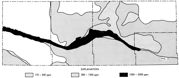
Figures 6 and 7 are areal representations of the specific conductance and total dissolved solids data, respectively, for irrigation waters from the study region. Both figures indicate the greatest dissolved salts load is associated generally with groundwaters from the Arkansas River valley in Hamilton, Kearny, and Finney counties, with the amount of dissolved solids decreasing from west to east. The soil association in this area is the Las-Bridgeport-Las Animas group which is saline. Waters of higher specific conductance and total dissolved solids are found to extend out of the river valley in a band north and west of Garden City in Finney County to about the Kearny-Finney County line. In Gray County, groundwaters from the river valley, which are associated with the Las Animas-Lesho-Bridgeport soil group, appear to be more similar in character to waters from the sandy regions south of the Arkansas River than to groundwaters from the western two-thirds of the river valley system in the study area.
Figure 6--Map of specific conductance for the study area. Levels correspond to medium, high, and very high salinity hazard ranges.

Figure 7--Map of total dissolved solids for the study area.
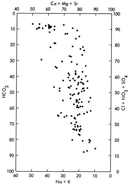
Areal concentration distributions for Na and SO4 are presented in Figures 8 and 9, respectively. The chemical quality data for the study area are also presented in a modified Piper diagram (Piper, 1944) in Figure 10. Factors for conversion from parts per million (ppm) to milliequivalents per liter are listed in Table 2. Water type classifications used in this report are based upon percent milliequivalent contributions of the various chemical species to the total number of milliequivalents per liter of cations or anions.
Figure 8--Map of concentration level of sodium for the study area.
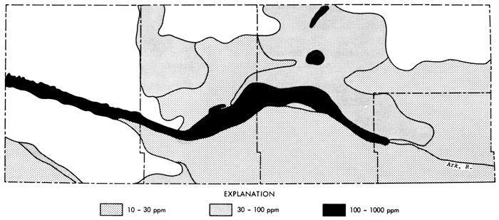
Figure 9--Map of concentration levels of sulphate for the study area.
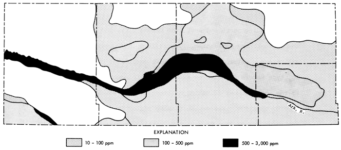
Table 2--Factors for conversion of parts per million to milliequivalents per liter.
| Species | Multiply By |
|---|---|
| Calcium (Ca) | 0.04990 |
| Magnesium (Mg) | 0.08226 |
| Sodium (Na) | 0.04350 |
| Potassium (K) | 0.02557 |
| Strontium (Sr) | 0.02283 |
| Bicarbonate (HCO3) | 0.01639 |
| Sulfate (SO4) | 0.02082 |
| Chloride (Cl) | 0.02821 |
| Fluoride (F) | 0.05264 |
| Nitrate (NO3) | 0.01613 |
Figures 8 and 9 indicate high levels of Na and SO4 are found in waters from the Arkansas River valley in Hamilton, Kearny, and Finney counties, immediately north of the river valley in Finney County in a band extending north and west from Garden City, and locally for Na in the Scott-Finney depression. Waters from this portion of the river valley are clustered in the upper left portion of Figure 10. These are SO4 type waters in which no single cationic species makes a contribution to the total number of cation milliequivalents which is equal to or greater than 50%. The cation ranking varies from Na > Ca > Mg in Hamilton County to a Ca > Na > Mg ranking in eastern Finney County. The more saline SO4 waters from the band north of the river in Finney County generally exhibit a ranking of Ca > Mg > Na. The boundary for the SO4 type waters in this region north of the river valley extends slightly beyond that of the high SO4 level of Figure 9. In western Gray County the SO4 type waters are found to extend into a narrow zone north of the river. These waters are of lower salinity than those in the band north of the river in Finney County, but possess the same ranking of cations (Ca > Mg > Na).
Figure 10--Modified Piper diagram for ground waters in the study area. Values represented are the milliequivalent contributions of chemical species to the total milliequivalents per liter of cations or anions.
The greater Na, SO4, and total dissolved solids contents of groundwaters in the band north of the river valley near Garden City may be related to buried saline soil horizons in the lower portions of the Scott-Finney depression and/or irrigation practices using water from the Arkansas River which have produced a saline soil in this area (Harner et al., 1965; Meyer, Gutentag, and Lobmeyer, 1970). The latter authors have noted that higher concentrations of total dissolved solids in Finney County are associated with regions having high water tables or depressions where water collects and salts are enriched through evaporation. Irrigation in areas of saline soils and higher water tables can be expected to lead to deterioration of the local groundwater quality as salts are flushed down into the water table.
Groundwater from wells in the eastern three-fourths of the Arkansas River valley in Gray County is relatively low in its Na and SO4 content. These waters are Ca-HCO3 in character, plot in the lower one-third of the central portion of Figure 10, and appear to be more closely related to waters from the sandy areas south of the river than to waters from the western two-thirds of the river valley in the study area. Meyer et al., (1970) have noted that the Arkansas River tends to be a losing stream in Finney County, and McGovern and Long (1974) indicate it becomes a gaining stream in Gray County. Preliminary evaluation of the chemical quality data suggests the change in character of the river valley waters in Gray County is dominated by inflow of groundwater from the sandy regions south of the river.
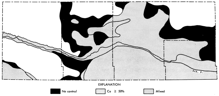
Groundwater samples from north of the Arkansas River, excluding the band of SO4 type water near Garden City, tend to be mixed type waters for the most part in which Ca > Mg > Na and HCO3 > SO4. Locally within the Scott-Finney depression, areas exist where SO4 ≥ 50% and Na or Mg become the dominate cationic species. Notable exceptions to the above trends are: 1) HCO3 ≥ 50% for an area northwest of Lakin in Kearny County and for much of the outer perimeter of the mapped area north of the river in Kearny, Finney, and Gray counties, and 2) Ca ≥ 50% in waters from an area along the Kearny-Finney county line north of the river.
Values of total dissolved solids and specific conductance for groundwaters from the sandy regions south of the Arkansas River in Kearny, Finney, and Gray counties include the lowest measured in the study area. The waters from this area are a Ca-HCO3 type and tend to cluster in the lower one-third of Figure 10.
Samples from southwestern Hamilton tend to be Ca-HCO3-SO4 waters, except for samples taken from wells located along Bear Creek. In these wells there is an enrichment in dissolved salts and the waters tend to be of a Ca-SO4 type. The water classifications for the entire study area are summarized in Figures 11 and 12. Areas shown as having no control within the mapped region are those areas in which samples were not available for extension of the water type boundaries.
Figure 11--Groundwater classification by anion type.
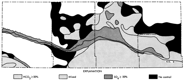
Figure 12--Groundwater classification by cation type.
The Arkansas River has a strong influence on the distribution patterns of K, Mg, and Cl as well as that already noted for Na and SO4. The highest K concentrations (10-20 ppm) are observed in the river valley westward from Finney-Gray county border and the band of SO4 type waters north of the river in Finney County. The lowest K concentrations (1.9-2.8 ppm) occur in portions of the sandy regions of Kearny and Finney counties south of the river. The distribution of high (90-236 ppm) concentrations of Mg is similar to that of K. Moderately high concentrations of Mg occur locally in the Scott-Finney depression. The sandy regions of Kearny, Finney, and Gray counties south of the river exhibit the lowest Mg concentrations (5.9-12 ppm). The highest Cl concentrations (106-331 ppm) occur in Hamilton and Kearny counties in the river valley and in Finney in the band of SO4 type waters north of the river, the river valley eastward from Garden City to the Finney-Gray County border, and locally within the Scott-Finney depression. Very low Cl concentrations (<2 ppm) occur in portions of the sandy areas of Kearny and Finney counties south of the river.
Levels of F greater than 1.5 ppm are generally associated with waters from north of the Arkansas River in Finney and Gray counties, and are mainly concentrated above a line running from the northwest corner of Finney County to the river at the Finney-Gray County border. In Gray County, high fluoride levels coincide fairly well with the occurrence of HCO3 type waters. General trends for NO3 are much less apparent than those noted for other species.
The foregoing discussion has treated chemical quality aspects of the study area as if the area was only two dimensional, i.e., no variation in quality with depth in the aquifer. This is necessitated in most cases by a lack of information regarding screened intervals in the wells used in this study. Meyer, Gutentag, and Lohmeyer {1970) have found concentration variations in the total dissolved solids for waters from Tertiary and Quaternary deposits along a north-south traverse in Finney County (through the Garden City area). Variations in chemical quality of groundwaters generally can be expected to be smeared out downdip of the water table, however intensive pumping of wells neighboring and somewhat updip of zones of poorer water quality might be able to cause a local deterioration of groundwater quality under favorable hydrologic conditions which lead to a local reversal of the water table gradient.
Figure 13 is an areal presentation of the sodium-adsorption-ratio (SAR) for the study area. SAR values are computed using the equation
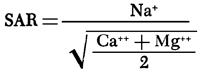
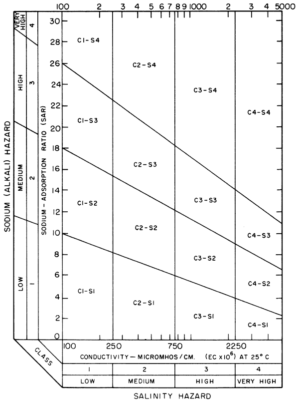
where values in parentheses are milliequivalents per liter of the specified ions. SAR and specific conductance values can be used to evaluate alkali and salinity hazards, respectively, in regard to suitability of a water for irrigation purposes (U.S. Salinity Laboratory Staff, 1954). Levels for specific conductance in Figure 6 correspond to medium, high, and very high salinity hazard classifications.
Figure 13--Map of values of the sodium adsorbtion ratio for the study area.

The general range of SAR values for the SO4 type waters of the Arkansas River valley in Hamilton, Kearny, and Finney counties and localized sites in the Scott-Finney depression is 3-9. Values in the range of 0.2-l are typical for most of the study area south of the river and north of the river in Gray County. Figure 14 relates SAR values to specific conductance values for determining the suitability of a water for irrigation.
Figure 14--Diagram showing the relationship between specific conductance and the sodium adsorption ratio in evaluation of salinity and alkali hazards for irrigation waters.
In summary, the chemical quality of groundwaters in the study is complex, with sandy areas south of the Arkansas River exhibiting the best chemical quality (low total dissolved solids, SAR, etc.) and the western three-fourths of the Arkansas River valley and portions of the Scott-Finney depression exhibiting the poorest chemical quality. Poorer water quality tends to correlate with the presence of saline soils and the existence of a high water table and/or small, poor draining shallow depressions. The similarity between water from the Arkansas River valley in Gray County and water from the sandy areas south of the river in that region suggests that groundwater movement from the sandy regions is a dominant factor in the change in chemical quality of waters of the river valley near the Finney-Gray County border.
The services of personnel from the U.S.G.S office in Garden City, Kansas, in collection of the water samples; and A.M. Diaz of the U.S.G.S. office in Lawrence, Kansas, in operation of the field laboratory are gratefully acknowledged. The authors are also indebted to G.W. James, K.G.S., for help in preparation of maps, and J. Budai, K.G.S., for help in the field laboratory.
A special note of thanks is due Dr. H. Goode, Superintendent of Schools, and Mr. M. Wiederstein, Principal, Alta Brown Elementary School, Garden City, Kansas, for making school facilities available for the field laboratory.
Bayne, C.K. and U.S.G.S. Staff in Garden City, Kansas, 1975, General Availability of Groundwater and Normal Annual Precipitation in Kansas: Kansas Geological Survey Map M-4A.
Gutentag, E.D., Lohmeyer, D.H., and McGovern, H.E., 1972, Groundwater in Finney County, Southwestern Kansas: U.S. Geological Survey Hydrologic Investigations Atlas HA-442.
Gutentag, E.D., Lohmeyer, D.H. and McGovern, H.E., 1972, Groundwater in Kearny County, Southwestern Kansas: U.S. Geological Survey Hydrologic Investigations Atlas HA-416.
Harner, R.F., Angell, R.C., Lohmeyer, M.A. and Jantz, D.R., 1965, Soil Survey of Finney County, Kansas: U.S. Department of Agriculture, Series 1961, No. 30, 91 p.
Hathaway, L.R., Magnuson, L.M., Carr, B.L., Galle, O.K. and Waugh, T.C., 1975, Chemical Quality of Irrigation Waters in West-Central Kansas: Kansas Geological Survey, Chemical Quality Series 2, 46 p.
Lohmeyer, D.H. and Sauer, C.G., 1974, Groundwater in Hamilton County, Southwestern Kansas: U.S. Geological Survey Hydrologic Investigations Atlas HA-516.
McBee, C.W., Fleming, E.L., Hamilton, V.L. and Sallee, K.H., 1961, Soil Survey of Hamilton County, Kansas: U.S. Department of Agriculture, Series 1958, No. 10, 43 p.
McGovern, H.E. and Long, W.A., 1974, Groundwater in Gray County, Southwestern Kansas: U.S. Geological Survey Hydrologic Investigations Atlas HA-517.
Meyer, W.R., Gutentag, E.D. and Lohmeyer, D.H., 1970, Geohydrology of Finney County, Southwestern Kansas: U.S. Geological Survey Water-Supply Paper 1891, 117 p.
Sallee, K.H., Hamilton, V.L., McBee, C.W. and Fleming, E.L., 1963, Soil Survey of Kearny County, Kansas: U.S. Department of Agriculture, Series 1959, No. 32, 70 p.
Smith, H.T.U., 1941, Geological Studies in Southwestern Kansas: Kansas Geological Survey, Bulletin 34, 212 p.
Tomasu, B.I. and Roth, W.E., 1968, Soil Survey of Gray County, Kansas: U.S. Department of Agriculture, 59 p.
U.S. Salinity Laboratory Staff, 1954, Diagnosis and Improvement of Saline and Alkali Soils: U.S. Department of Agriculture Handbook, 60, 160 p.
Kansas Geological Survey
Placed on web Oct. 10, 2012; originally published in 1977.
Comments to webadmin@kgs.ku.edu
The URL for this page is http://www.kgs.ku.edu/Publications/Bulletins/CQS4/index.html