![]()
Prev Page--Stratigraphy--Kansan Stage || Next Page--Stratigraphy--Wisconsinan Stage
Pleistocene Stratigraphy in Kansas, continued
Yarmouthian Stage
Evidence of Yarmouthian time in Kansas is preserved in the Yarmouth soil, and perhaps locally in the uppermost part of the Sappa member of the Meade formation, which may be earliest Yarmouthian in age. Evidence of Yarmouth soil development extends generally over northern, central, and western Kansas, but only at a few places has a Yarmouth soil been observed where an uneroded profile is developed in Kansan sediments, overlain by known Illinoian sediments. A complete Yarmouth profile has been studied by Alvin R. Leonard and by us in the SW SE sec. 13, T. 2 S., R. 10 W., Jewell County. Here the Sappa beds below the profile are fossiliferous and it is overlain by Loveland loess containing a well-developed Sangamon soil in the top which is in turn overlain by Peoria loess. At this locality the profile suggests somewhat poorly drained conditions on the Yarmouth soil surface. The partly eroded lower part of a Yarmouth profile overlain by Loveland loess occurs at the Iowa Point section in Doniphan County and at several other localities in Atchison, Doniphan, and Brown counties.
A Yarmouth soil profile of strikingly different morphology is exposed in an abandoned gravel pit 1.5 miles southeast of Washington in Washington County. Here the profile is developed in relatively coarse Grand Island outwash gravels which are overlain by colluvium of presumed Illinoian age. The A horizon of the profile has been removed by erosion but 3 to 5 feet of leached zone is exposed below the colluvium in the pit face. The base of the leached zone is sharp and marks the upper limit of Permian limestone pebbles, abundant in the unleached gravel below. The deep graveliferous B horizon is reddish brown in color with a relatively high clay content in the interstices of the gravel.
A profile developed on Kansan sediments but lacking an Illinoian cover has been observed at many localities in central and southwestern Kansas. Such a profile was studied in auger holes in eastern Reno County by James Thorp, W. I. Watkins, and us, and in this area under flat surfaces this Yarmouth-Sangamon (perhaps also Brady) soil is quite deep with a heavy B horizon and caliche nodules more than 3 inches in diameter. West of Meade, Meade County, highway cuts expose a Yarmouth-Sangamon soil developed in Sappa silts and overlain by Peoria loess. Here this soil (A horizon removed by erosion) is dark red and the caliche has been welded into vertical nodular stringers below an almost continuous zone of nodular caliche. The total caliche zone commonly exceeds 3 feet in thickness.
In east-central Kansas a soil on the Emporia terrace below a thin veneer of Peoria loess may be a Yarmouth-Sangamon profile. Also in this area some bedrock residual soils may have started their development in Yarmouthian time.
A soil buried beneath thin Peoria loess occurs extensively in the central part of the glaciated area of northeastern Kansas; it is well exposed in fresh cuts along Highway U.S. 36 west of Hiawatha, Brown County. Wedges of colluvium, as much as 4 or 5 feet in thickness on the lower part of gentle slopes and rarely exceeding a foot or 2 in the crests of spurs, rests on oxidized Kansas till (both leached and unleached) with a distinct concentration of cobbles and pebbles at the "contact" or slip-plane. A deep well-drained reddish-brown profile occurs extensively in the top of this colluvial veneer and below Peoria loess. Although this profile may be a Yarmouth-Sangamon soil, it is judged more likely that the Yarmouth soil--formed on an essentially uneroded till plain surface--was destroyed by erosion, that the colluvial veneer developed in Illinoian time, and that the buried soil is the Sangamon, because the present well-drained topography of the region had been formed before this buried profile developed.
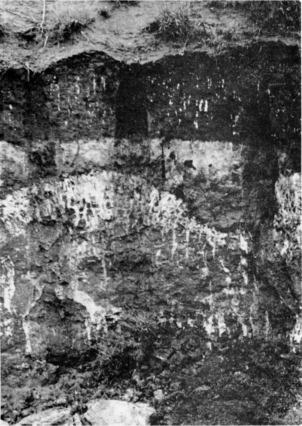
In the relatively little-dissected High Plains area of west-central and northwestern Kansas a buried soil consistently occurs on the eroded Ogallala below a cover of Peoria loess. Although the culmination of the development of this buried soil was during Sangamonian time, some exposures show evidence of multiple cycles of soil development (Pl. 10) that probably include the Yarmouth soil.
Plate 10--Complex of buried soils developed in Ogallala formation and overlain by Peoria loess. Three generations of caliche, the lowest (oldest) of which may be as old as Aftonian, are overlain by Peoria loess capping ther High Plains surface. Exposure in road-side gully, SE NE sec. 33, T. 10 S., R. 28 W., Sheridan County (1950).
The evidence, as it has been observed in Kansas, indicates that when the Yarmouth soil is compared with the Afton and Sangamon soils from situations of similar parent material, drainage, and climate, the three soils display an approximately equivalent stage of development, although all three soils show a strong contrast from east to west and from north to south across the State.
Sanborn Formation
The Sanborn formation, unlike all other stratigraphic units of formational rank in the Kansas Pleistocene, includes deposits of two stages (Illinoian and Wisconsinan) and the several substages of the Wisconsinan. Furthermore, it includes two unconformities, defined by the Sangamon and Brady buried soils, and represents three distinct cycles of deposition. In the official classification of the Kansas Geological Survey the Sanborn formation includes, in ascending order, the following members: (1) Crete sand and gravel member; (2) Loveland silt member, commonly containing within its top the Sangamon buried soil; (3) unnamed early Wisconsinan alluvial deposits; (4) Peoria silt member, commonly containing within its top the Brady buried soil; (5) unnamed late Wisconsinan alluvial deposits; and (6) Bignell silt member. Although three cyclic units, each of which is genetically comparable to the Meade or Blanco formation, are represented by the Crete-Loveland-Sangamon, by the early Wisconsinan alluvium-Peoria-Brady, and by the late Wisconsinan alluvium-Bignell-topsoil, it is judged to be advisable to retain the broadly inclusive Sanborn as the unit of formation rank as an expedient to mapping. The eolian or loess phase of the three members is widely distributed in upland areas in situations that make it impracticable to separate them for field mapping on conventional map scales. The several members of the formation will be discussed by geologic stages as have the older units of the Kansas Pleistocene.
The name Sanborn formation was first proposed by Elias in 1931 (p. 163), as follows:
The name Sanborn formation is proposed for the loess, with some gravel and sand at the base, which is widely distributed on the divides in western Kansas. The name is intended as a substatute [sic] for the old terms "Tertiary marl" or "Plains marl" introduced for this formation by Robert Hay. The new name is derived from Sanborn, Neb., which is the nearest town to a locality of the formation in the northwestern corner of Cheyenne county, Kansas, where loess attains a thickness of 180 feet. Loess is exposed here in steep bluffs of numerous canyons on the south side of Arikaree river. Loess is underlain here by a few feet of Ogallala and by the Pierre shale.
Concerning the upper, or loess, part of the formation Elias (1931, p. 179) restricted the name Sanborn to the loess of the divide area as follows:
It seems to the writer that only the loess that covers the divides can be considered to be of Pleistocene age, the loess of the valley slopes and bottoms being largely if not wholly redeposited from the divides, the redeposition having taken place probably for the most part in late Pleistocene and Recent times. At any rate redeposition of the topographically higher loess to the lower areas is still going on, the wind and surficial waters being the chief agents of transportation.
Although Elias did not give a measured section for the type, or specifically designate a type section, he later agreed (Frye and Fent, 1947, p. 41) that the exposures in canyons extending from the NW sec. 20, T. 1 S., R. 41 W. into the adjacent SW SE sec. 17, T. 1 S., R. 41 W., Cheyenne County (Pl. 11E) were in his type area and constituted a suitable type section. A measured section from these canyons is given below. At the type locality the Sanborn consists of water-laid Crete and Loveland capped with Sangamon (Brown) soil containing remains of Citellns richardsoni, overlain by Peoria loess which contains a sparse molluscan fauna. Brady soil and the overlying Bignell loess are well exposed in road cuts in the central part of Cheyenne County (SE SE sec. 28, T. 3 S., R. 39 W.).
| Type locality of Sanborn formation, section measured in canyon on the south side of Arikaree River in the SW SE sec. 17, T. 1 S., R. 41 W., Cheyenne County. | Thickness, feet |
||
| QUATERNARY--Pleistocene | |||
| Sanborn formation | |||
| Peoria member (Wisconsinan Stage, Iowan and Tazewellian Substages) | |||
| 6. Silt, massive, calcareous, light-tan; contains very fine sand in lower part, sparsely fossiliferous in middle, upper part largely covered | 90.0 | ||
| Crete-Loveland member (Illmoian Stage) | |||
| 5. Silt and fine sand; Sangamon soil in upper part, light-brown, small amount of clay in B horizon, weakly developed vertical structure, weakly calcareous; contains fossil remains of Citellus richardsoni | 3.0 | ||
| 4. Silt and very fine sand, massive, calcareous, tan to buff | 3.0 | ||
| 3. Silt, fine sand, very fine sand, and a few thin beds of clay, interbedded; thin to moderately thick-bedded, tan, buff, and gray, mostly calcareous. In adjacent canyons, both east and west, the top of the Ogallala formation is in a position near or above the top of this interval | 24.0 | ||
| 2. Silt, sand, and gravel, in erosional channel cut through the Ogallala formation and into underlying Pierre shale. Gravels and sand are poorly sorted, irregularly bedded to massive, and contain many pebbles derived from Ogallala and Cretaceous rocks | 10.0 | ||
| Total thickness of Sanborn formation measured | 130.0 | ||
| CRETACEOUS--Gulfian | |||
| Pierre shale | |||
| 1. Shale, weathered, bentonitic, coffee-colored, to bottom of canyon and along canyon to level of Arikaree River | |||
Subsequent to Elias' naming of the Sanborn formation it was used as a broadly inclusive unit, embracing virtually all the Pleistocene deposits in northwestern and north-central Kansas (Leonard and Frye, 1943; Hibbard, Frye, and Leonard, 1944; Frye, 1945, 1945a; Byrne, Coombs, and Bearman, 1947, 1949; Byrne, Beck and Houston, 1948, 1949; Byrne, Houston, and Mudge, 1948, 1950; Byrne, Beck, and Bearman, 1949; Byrne and others, 1950, 1950a; Byrne, Coombs, and Matthews, 1951; Byrne, Johnson, and Bergman, 1951). However, by 1947 (Frye and Fent) it was proposed that the formation be restricted to the span of rocks described here. In recent years this restriction has been followed generally (Frye, Swineford, and Leonard, 1948; Frye and A. R. Leonard, 1949; Frye and others, 1949; Fent, 1950; Moore and others, 1951; Frye and A. B. Leonard, 1951; Swineford and Frye, 1951).
Various locally named units in Kansas that consist in part or entirely of deposits known to be of Illinoian or younger age, and which are properly classed at least in part as Sanborn formation, include the "Bluff formation" (Hawn, 1866), "Plains marl" or "Tertiary marl" (Hay, 1885, 1893; Haworth, 1897, 1897a; Williston, 1899), "Salt Creek gravel beds" (Logan, 1897), "Sheridan beds" (Scott, 1897), "McPherson Equus beds" (Haworth and Beede, 1897; Beede, 1898), "Kingsdown marl" or formation (Cragin, 1896; Smith, 1940; Frye and Hibbard, 1941; Hibbard, 1949b), "Belleville formation" (Wing, 1930), "Gerlane formation" (Knight, 1934; Frye, 1945a), "equus niobrarensis beds," "Jones Ranch beds," and "Odee formation" (Smith, 1940), and "Vanhem formation" (Hibbard, 1949b).
Illinoian Stage
During the Illinoian Age continental glaciers were more remote from Kansas than during any of the other glacial ages. During the Nebraskan and Kansan Ages continental glaciers invaded northeastern Kansas, and during the Wisconsinan, continental glaciers of each of the four glacial sub-ages either crossed the Missouri Valley north of Kansas or invaded major tributary valleys of the Missouri. In contrast, the closest approach to Kansas of clearly identified Illinoian continental glacial deposits is extreme eastern Iowa and western Illinois. Quantitatively, deposits of the Illinoian Stage in Kansas are far less important than the preceding Kansan, and, although more widespread, are volumetrically comparable to the Nebraskan. In Kansas this stage consists predominantly of stream-laid gravel, sand, and silt with a minor quantity of eolian silt or loess.
Alluvial Illinoian deposits have their maximum development along the valleys of central and north-central Kansas and are relatively minor elsewhere. Loess of the Illinoian Age also has its maximum development in this same general area. The Illinoian Stage in Kansas is represented by the Crete and Loveland members of the Sanborn formation.
Crete Member, Sanborn Formation
The name Crete formation was proposed for Nebraska usage in 1947 by Condra, Reed, and Gordon (p. 24) from a type locality in road cuts west of Crete, Saline County, Nebraska, in the NE sec. 32, T. 8 N., R. 4 E. They state concerning the formation:
The Crete formation is a channel fill deposit which rests unconformably upon the Upland [Sappa] formation or older Pleistocene deposits and is believed to be Illinoian in age. It is variable in composition depending upon the local material available for reworking in Crete time. Thus we find that the Crete consists of sand and gravel reworked from Kansan till or late Kansan sands and gravels in the narrower Crete channels in Eastern Nebraska and Western Iowa; that it consists of sands and some gravels which resemble the Grand Island formation in the broad through valleys of east central Nebraska; and that it consists of sands and gravels rich in pink feldspars of western source in Central and Western Nebraska modified by contributions of pebbles and boulders of reworked Ogallala or older formations where it occurs not too distant from bedrock outcrops.
In Kansas the Crete member of the Sanborn formation has been described briefly for the State by Frye and A. B. Leonard, (1951, p. 293), and in more detail for specific areas by Frye and A. R. Leonard (1949), Berry (1952), A. R. Leonard and D. W. Berry (in preparation), and Davis and Carlson (1952). Its geographic distribution is shown on the map in Plate 1, and its regional stratigraphic relations in the generalized cross sections in Plate 2. In alluvial deposits the separation of Crete and Loveland members is arbitrary, the sand and gravel deposits being classed as Crete and the predominantly silty upper part of the alluvial sequence classed as Loveland. In some areas where silt and sand are interbedded a distinction between the two members is not attempted and the deposits are classed as Crete-Loveland. The eolian silt (loess) of the upland areas that is stratigraphically equivalent to these deposits is, of course, classed as Loveland member.
In the glaciated area of northeastern Kansas the Crete member is relatively unimportant, occurring in isolated small outcrops. Along the Kaw Valley Crete deposits underlie the surface of disconnected small remnants of the Buck Creek terrace (Davis and Carlson, 1952). This terrace, named for a small area at the mouth of Buck Creek Valley on the north side of Kaw Valley, northwest of Lawrence, stands in an intermediate position between the prominent Menoken terrace of Kansan age and the nearly continuous low Newman terrace of the Wisconsinan and Recent Ages. Test drilling (Davis and Carlson, 1952) shows that the bedrock floor of the valley was cut to within approximately 20 feet of the bedrock floor below the Newman terrace before the deposition of the Buck Creek terrace fill and therefore a major episode of valley incision occurred after the deposition of the late Kansan Meade formation in the valley and prior to the deposition of the late Illinoian Crete member. Where preserved in the Kansas River Valley the Crete consists predominantly of sand with some silt and contains some gravel in the lower part. In the Smoky Hill River Valley, southwest of Junction City, one small remnant of Crete has been studied in a terrace that is comparable in situation to the Buck Creek terrace eastward in the Kaw Valley. At this locality a molluscan fauna was obtained from the Crete-Loveland deposits.
The Crete member has not been identified in the Missouri River Valley in Kansas.
In the area south of Kansas River Valley and east from the crest of the Flint Hills the Crete member is judged to be represented by the highest elements of the low terrace complex, distinctly below the level of the Emporia and equivalent terraces. Positive identification of Crete in this area has thus far not been possible.
The Crete member is well developed in north-central Kansas where it occurs as local gully fills and as persistent terraces along the major valleys. In this area the Crete closely reflects the lithology of the drainage basin containing the deposit. At some places local deposits of Crete consist largely of caliche pebbles with some pebbles of Cretaceous chalk (SW SE sec. 6, T. 2 S., R. 4 W., Jewell County where Crete rests on Sappa silt and contains a diagnostic snail fauna), or of pebbles of Ogallala "mortar beds" (SW SW sec. 29, T. 1 S., R. 21 W., Norton County). The reflection of local source, even in major valleys of the region, is illustrated by disconnected remnants of a low terrace underlain by Crete gravels along Saline Valley. In central Russell County (secs. 34, 35, and 36, T. 12 S., R. 14 W.) the Crete consists largely of pebbles of Greenhorn limestone (Cretaceous) that caps the valley walls and crops out along the tributaries, whereas eastward in central and eastern Lincoln County (Berry, 1952) the Crete contains a large percentage of pebbles derived from the Dakota formation which constitutes most of the area of the valley sides. In northeastern Lincoln County and adjacent Ottawa County the Crete terrace along Salt Creek Valley is low and lithologically reflects the Cretaceous bedrock of the valley walls. The gravels are locally cemented, and at one locality (NE NW sec. 29, T. 10 S., R. 5 W., Ottawa County) are cut deeply into the Sappa member (including Pearlette volcanic ash) of the Meade formation.
The Crete member is well developed and present almost continuously along the valleys of Prairie Dog Creek across Norton and Phillips counties (Frye and A. R. Leonard, 1949) and the North Fork Solomon River eastward from Norton County (A. R. Leonard, 1952). In these valleys it has been studied in detail both by surface methods and test drilling, and in both valleys occurs as a persistent terrace along the north side of the valley. In Prairie Dog Creek Valley the accumulation of Wisconsinan loesses on the terrace surface and the valley side slope has masked the physiographic expression of the terrace to such an extent that it is difficult to limit cartographically without benefit of subsurface data; the Crete sands are well exposed at a few localities (NW NW sec. 8, T. 3 S., R. 23 W., Norton County). Along the North Fork Solomon River Valley the mantle of Wisconsinan loesses is thin and the terrace underlain by Crete has a recognizable physiographic form.
In the northwestern part of Kansas major through-flowing valleys do not exist and the Crete terraces in the headwaters portions of valleys in that area are discontinuous or indistinguishable. Thin deposits of Crete from local sources, however, are not uncommon (Pl. 11A, 11E).
Plate 11A--Peoria loess and Sangamon soil. Fossiliferous Peoria loess, 35 feet thick, on Sangamon soil in Crete-Loveland, on Ogallala. Brady soil and Bignell loess at top of cut; sec. 2, T. 3 S., R. 33 W., Rawlins County (1948).
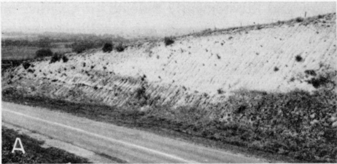
Plate 11B--Peoria loess and Sangamon soil. Fossiliferous Peoria loess in cut of Chicago, Rock Island, and Pacific Railroad, SW NW sec. 8, T. 8 S., R. 35 W., Thomas County. Peoria is 30 feet thick (1943).
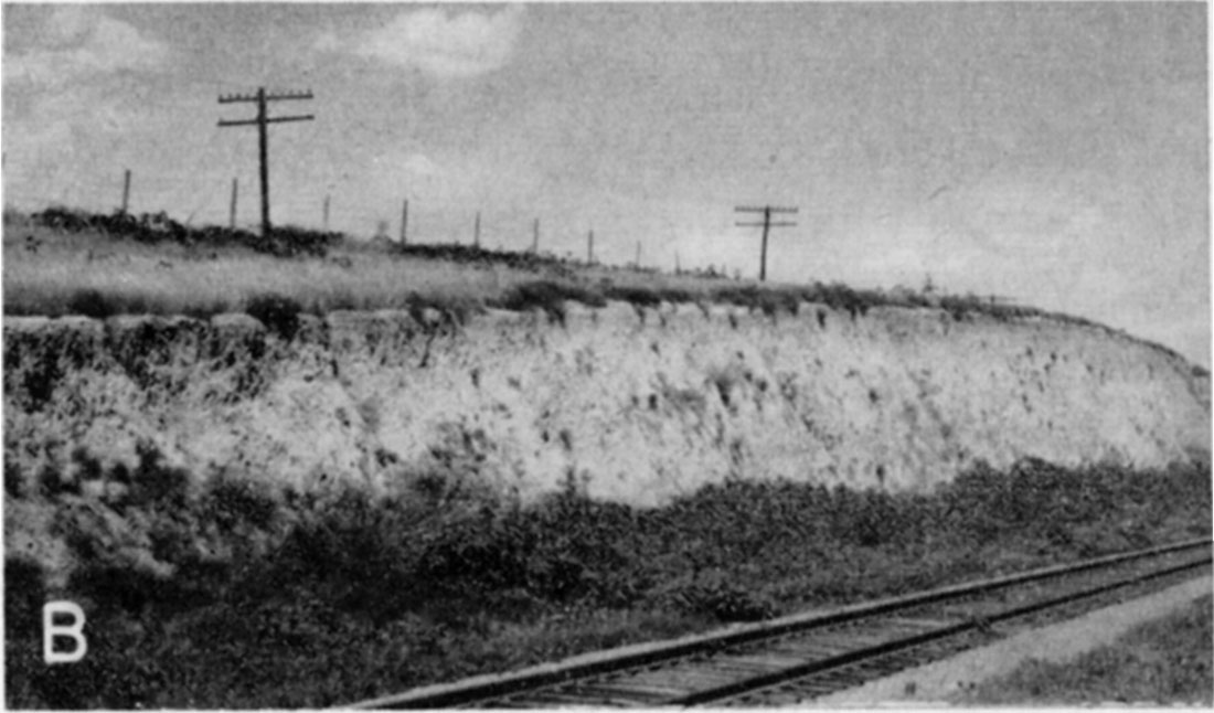
Plate 11C--Peoria loess and Sangamon soil. Peoria loess with well-developed Chemozem soil in top, on eroded Sangamon soil in fossiliferous Crete-Loveland. Cretaceous Dakota formation (not shown in photo) at base. NW SW sec. 35, T. 17 S., R. 13 W., Barton County (1949).
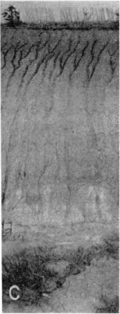
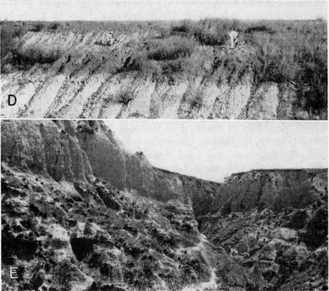
Plate 11--Peoria loess and Sangamon soil. D, Peoria loess on Sangamon soil in thin Loveland loess on Cretaceous Greenhorn limestone. The Sangamon profile is deep, poorly drained, nearly black in upper part. NW NW sec. 9, T. 3 S., R. 1 W., Republic County (A. R. Leonard, 1948). E, Peoria loess (90 feet thick and sparsely fossiliferous) on Sangamon soil yielding Citellus richardsoni in Crete-Loveland, on Cretaceous Pierre shale. Type locality of Sanborn formation, SW SE sec. 17, T. 1 S., R. 42 W., Cheyenne County (1948).
In Kansas the best exposures of Crete sand and gravel occur within the valley of Smoky Hill River in the western half of the State (Fig. 4). In Wallace County, adjacent to the Colorado State line, discontinuous and local deposits of Crete have been observed, and from western Logan County eastward into central Kansas the Crete gravels form a persistent upper part of the Kansan-Illinoian (Pfeifer) terrace along the valley. The Crete is well exposed in this area (particularly where it overlies Meade formation on the north side of Smoky Hill River in sec. 29, T. 14 S., R. 21 W., Trego County) and has been described in Trego and Ellis counties by A. R. Leonard and D. W. Berry (in preparation). Some of the better exposures were mentioned in the preceding discussion of the Meade formation (Kansan) associated with the prominent terrace along this valley.
In western McPherson County subsurface data (O. S. Fent, personal communication) show Crete gravels to overlie unconformably the Sappa member of the Meade formation which constitutes the major part of the fill in this abandoned valley. As these gravels fit approximately the projected gradient of the Crete terrace deposits extending 200 miles west along Smoky Hill Valley it is judged that the drainage from this valley continued southward through the McPherson valley until after Illinoian time.
Crete gravels have their greatest quantitative development in the region south of the great bend of the Arkansas River, but in much of this region outcrops are poor and they are known primarily from subsurface data (D. W. Berry, in preparation; O. S. Fent, in preparation, personal communication). Crete gravels resting on Sappa silts are exposed in west-central Kingman County and central Pratt County (for example, SW cor. sec. 23, T. 27 S., R. 11 W., where Crete gravels overlie sandy Sappa containing Pearlette volcanic ash). The extent of Crete gravels in this region is shown on the map (Pl. 1) and the cross sections (Pl. 2).
In southwestern Kansas the Crete member has been recognized with certainty at very few places and it seems evident that it is quantitatively not important in that area. It should be remembered, however, that the separation of the Crete and Loveland members, where they are both water-laid, is arbitrary and is based on the texture of the sediment. Therefore, some deposits that are classed as Loveland or Crete-Loveland in this report might be considered by other workers to be more properly classed as Crete.
Loveland Member, Sanborn Formation
The name Loveland was first proposed by Shimek (1909; 1910) from exposures in the east bluff of Missouri River Valley at the town of Loveland, Iowa (the type locality is listed by Kay and Graham, 1943, p. 64, as sec. 3, Rockford Township, T. 77 N., R. 44 W., Pottawattamie County). Shimek described the formation as compact reddish or yellowish silt and clay, occurring stratigraphically above Kansas till and below the buff (Peoria) loess. Kay and Graham (1943, pp. 63-64) reviewed the history of the term and its expansion to include sand and gravel deposits below the reddish silt and clay. They considered the silt and clay to be eolian in origin and referred to it as loess. Lugn (1935) has described in detail the Loveland formation in Nebraska which he considered to consist of two phases, a "valley phase" of water-deposited gravel and sand and a "loess phase" of eolian silt (Lugn 1935, p. 128). He stated that the Loveland occupies a stratigraphic position unconformable upon the Upland (Sappa) formation and is terminated upward by a soil below the Peorian loess. In 1947 Condra, Reed, and Gordon (pp. 25-28) reviewed the Loveland formation in Nebraska and by the designation of the Crete as a separate formation removed the alluvial gravels from the Loveland.
The Loveland member in Kansas was discussed by Frye and A. B. Leonard (1951, pp. 294-298) who state (p. 295): "The term 'Loveland silt member' is applied in Kansas both to the waterlaid silts in valley situations and to the loess of the uplands. The two facies of the silt unit have been determined to be stratigraphically continuous along some valley-side slopes, occupy the same stratigraphic position, are the same age, and can be mapped together conveniently." It is appropriate to add that at some localities it is difficult to determine in the field if Loveland silts are of fluviatile or eolian origin. Shimek's original type locality is generally accepted and has been restudied by us. At the type section the upper 22 to 24 feet of the Loveland is within the profile of the Sangamon soil, is leached of primary calcium carbonate, and has the reddish cast Shimek described. The basal few feet of the type Loveland, however, is calcareous, contains a zone of caliche nodules just below the leached material, is similar lithologically and in color to the younger loess at the same locality, and contains a meager but distinctive molluscan fauna (Frye and A. B. Leonard, 1951, p. 294).
In Kansas, Loveland loess has been recognized along Missouri and Kansas River Valleys and in the north-central, central, and southwestern areas. The Loveland silt member has been studied along Kansas River Valley and many of the valleys of the north-central, northwestern, and central regions where it consists of water-laid sediments. Alluvial Loveland silt occurs as the upper part of the deposits of the Buck Creek terrace of Kansas River Valley (Davis and Carlson, 1952). In the glaciated area of northeastern Kansas Loveland loess is well-exposed in Doniphan (Iowa Point section) and Brown (SE SE sec. 23, T. 2 S., R. 20 E.) counties and has been studied in auger holes and cuts in Atchison (SE sec. 32, T. 6 S., R. 21 E.), Leavenworth, and Wyandotte (SE sec. 2, T. 11 S., R. 24 E.) counties. The Loveland loess of this area is thin, rarely exceeding 20 feet in thickness, and its distribution is adjacent to the major valleys.
In northern Kansas the Loveland silt is a thin but distinctive and persistent unit westward from Republican River Valley for 200 miles (Hibbard, Frye, and Leonard, 1944; Frye and Fent, 1947; Frye and others, 1949; Frye and A. R. Leonard, 1949). In this area the secondarily imposed characters of the Sangamon soil almost completely mask the primary character of the Loveland member as at many localities where it was studied its entire thickness was found to be included within the Sangamon profile. In this north-central area the Loveland member occurs not only as an upland loess (Jewell, Smith, and Phillips counties) but also as stream-laid silt (SW NW sec. 26, T. 2 S., R. 23 W., Norton County) and as colluvium on valley side slopes.
In northwestern Kansas thin Loveland loess occurs at only a few places although water-laid and colluvial deposits classed as Crete or Crete-Loveland are relatively widespread and the Sangamon soil continues to serve as a persistent and recognizable stratigraphic datum.
In the Smoky Hill Valley region of western Kansas, in spite of the extensive development of the Crete gravels, the Loveland member is quantitatively of small importance. On some valley side slopes silty colluvium (NW sec. 3, T. 16 S., R. 29 W., Lane County) of Illinoian age contains a well-developed Sangamon soil in its top and is overlain by fossiliferous Peoria loess.
In central Kansas the Loveland loess is well developed in some localities, particularly in Rice and McPherson counties (Frye and Fent, 1947; Fent, 1950). An exceptional exposure occurs in a road cut in the NW SW sec. 7, T. 18 S., R. 7 W., Rice County, where very thin Bignell overlies Brady soil in Peoria loess which rests on a humic-gley Sangamon soil in Loveland (fossiliferous in lower part) which rests on an eroded soil developed on the underlying clayey shale of the Cretaceous Dakota formation. Westward from Rice County Loveland loess occurs discontinuously on the Cretaceous upland overlain by Peoria and at some localities is fossiliferous (Pl. 11C).
In the southwestern corner of the State Loveland loess has not been recognized although sands have been observed in its stratigraphic position. Eastward in southwestern Kansas, relatively thick Loveland loess is exposed in Clark (NW sec. 3, T. 30 S., R. 24 W.) and Ford (sec. 22, T. 29 S., R. 23 W.) counties where it is overlain by thin fossiliferous Peoria loess.
Loveland loess has not been recognized in the chert gravel province east of the Flint Hills, although Sangamon soil, as a residual profile on shale, has been observed below thin Peoria loess.
The age of the Crete and Loveland members is established as Illinoian by stratigraphic framing on a regional and definitive basis. At several score localities the Crete and Loveland members can be demonstrated to be appreciably younger than the Sappa member of the Meade formation (late Kansan). As the time interval separating the Loveland from the Sappa was sufficient to permit, at some localities, the development of a mature Yarmouth soil profile (Jewell County) and at other localities the deepening of valleys through bedrock by more than 100 feet (A. R. Leonard, 1952), an age older than Illinoian is precluded. Furthermore, as the Loveland member contains, in its top, at several hundred localities studied, a mature Sangamon soil profile overlain by abundantly fossiliferous (early Wisconsinan) Peoria loess, an age younger than Illinoian is precluded. The Crete-Loveland contains a distinctive molluscan fauna that permits correlation with the type locality of the Loveland. In the glacial sequence of the central Missouri Valley region the Loveland has been framed stratigraphically between Kansas till and Sappa equivalents below and Iowa till above (Frye, Swineford, and Leonard, 1948). However, the absence of Illinois till in the Missouri Valley region prevents a direct correlation here of the Crete-Loveland with glacial deposits of this stage.
Sangamonian Stage
Record of Sangamonian time in Kansas is provided almost exclusively by the widespread, well-developed, and exceptionally well-preserved buried Sangamon soil. This soil has been studied in exposures, auger holes, and rotary test holes at several hundred localities distributed from the Missouri River Valley bluffs in northeastern Kansas to the Colorado state line and in central, west-central, and southwestern Kansas. It provides one of the best records of a former period of soil formation known in the geologic column. In Kansas this soil has been called a "soil in the Sanborn formation" (Hibbard, Frye, and Leonard, 1944), the "Loveland soil" (Frye and Fent, 1947), and the Sangamon soil (Frye and A. B. Leonard, 1951). As the term Sangamon was applied a half century ago to a soil in this stratigraphic position, the Kansas Geological Survey, following the usage of Thorp, Johnson, and Reed (1951), has adopted (Moore and others, 1951) Sangamon as the state-wide name for this buried soil.
As the original description of the Sangamon was based on an occurrence in the Mississippi River basin, the soil occurring in the upper part of the Loveland loess at the Loveland type section in Iowa has been used as a section of reference for work in Kansas. At Loveland, Iowa, the soil is well developed with a profile approximately 25 feet in depth. The zone of clay accumulation is 2 to 3 feet thick, shows well-developed structure, and is light red-brown in color; the upper 22 to 24 feet of the soil is leached of calcium carbonate, and a zone of caliche accumulation occurs at the base of the leached zone. The character of the profile indicates development under conditions of moderate to fair drainage. The Sangamon (or Loveland) soil has been described from many localities in Nebraska (Lugn, 1935; Schultz and Stout, 1945; Condra and Reed, 1950; Thorp, Johnson, and Reed, 1951). In much of the earlier literature on Nebraska the Sangamon soil has been referred to as a soil in the Citellus zone. The Citellus zone (Condra and Reed, 1950, p. 31) should be considered a faunal zone, characterized by the fossil remains of the ground squirrel for which it is named, and not a stratigraphic unit.
Unlike the older buried soils the Sangamon has been observed at a sufficiently large number of localities and throughout a region great enough in extent to make it possible to evaluate its morphological differences from place to place. Its physical character varies primarily in response to (1) conditions of drainage, (2) parent material, and (3) climatic factors correlated with geographic location. By comparing profiles controlled by similar conditions of drainage and parent material the strong effect of geographic location becomes obvious.
Concerning the character and environment of the Sangamon soil Thorp, Johnson, and Reed (1951, p. 12) state as follows:
On the Great Plains, it appears from the dark-colored A horizons and thick, reddish-brown clayey B horizons that the dominant vegetation probably was grass, and that the dominant well-drained soils were Reddish Prairie soils and reddish Chernozems with maximal textural contrasts between A and B horizons. However, eastward from eastern Nebraska and western Iowa, some of the buried Sangamon soils are podzolic and probably were developed under forest.
Sangamon soil has its maximum development in the area adjacent to the Missouri River Valley. This development is well displayed at the Loveland type section and other exposures in western Iowa, at the Iowa Point section and near-by exposures in Doniphan and Brown (SW sec. 12, T. 1 S., R. 18 E.) counties, Kansas, and at localities adjacent to the Missouri River as far south as Kansas City (SW sec. 2, T. 11 S., R. 24 E.).
Westward from the Missouri River in the glaciated area the Loveland loess becomes thin and discontinuous and Sangamon soil is developed on colluvial wedges on dissected Kansas till and is overlain by Peoria loess. The Sangamon soil where developed on thin colluvium is generally a well-drained profile with a tough B horizon that is a strong red-brown in color. Its configuration roughly conforms to the present topography. Where it is well exposed in cuts along U.S. Highway 36 west of Hiawatha in Brown County the soil is truncated low along the valley sides by subsequent erosion and the hilltops are capped asymmetrically by Peoria loess.
At the western margin of the glaciated area along Blue River Valley Sangamon soil occurs in thin Loveland loess (SE SW sec. 13, T. 1 S., R. 7 E., Marshall County) or as a residual soil on Permian shales (NW sec. 31, T. 2 S., R. 7 E. and NW NE sec. 36, T. 5 S., R. 8 E., Marshall County) overlain by thin Peoria loess. Westward in Washington County and eastern Republic County Sangamon soil is developed in thin Loveland loess and as a residual profile on Cretaceous Dakota formation and Greenhorn limestone (Pl. 11D). It is well exposed adjacent to Republican River Valley (SW sec. 9, T. 3 S., R. 4 W., Republic County; NE NE sec. 19, T. 8 S., R. 3 E., Clay County; SW sec. 34, T. 5 S., R. 2 W., Cloud County). In this area fossil remains of the rodent Citellus richardsoni, typical of this buried soil in Nebraska, have been collected at several localities.
West of Republican River Valley the Sangamon soil has been examined in auger holes where it is a poorly drained profile under thin Peoria loess that mantles much of the extensive plain on Cretaceous Carlile shale (NE NE sec. 15, T. 3 S., R. 5 W.), and on the uplands above the Fort Hays limestone scarp where this soil is generally a well-drained profile (NE SW sec. 25, T. 3 S., R. 8 W.; SW SW sec. 10, T. 3 S., R. 8 W.). The Sangamon soil is most extensively exposed in the area of western Jewell County, Smith (SE NE sec. 33, T. 3 S., R. 11 W.; NW SW sec. 29, T. 2 S., R. 14 W.) and Phillips (NW sec. 23, T. 2 S., R. 18 W.; SW SW sec. 24, T. 4 S., R. 19 W.) counties, and eastern Norton County. Here the buried soil is exposed at hundreds of places along valley sides, in plowed fields, and in road cuts; where exposed it is generally a moderately well-drained profile and from east to west becomes somewhat thinner and lighter colored. At some places where the soil is developed in sand the top of the caliche zone is a sharp but crenulate line (road cut, NW sec. 29, T. 4 S., R. 19 W., Phillips County). In central Norton County (SW NW sec. 11, T. 3 S., R. 23 W.) the B horizon is pale reddish brown and the depth of leaching commonly does not exceed 36 inches. As the Loveland loess is discontinuous in northwestern Kansas the Sangamon soil is commonly developed on water-laid or colluvial materials (Pl. 11A), but is exposed at many places (NE NE secs. 3 and 12, T. 3 S., R. 27 W., Decatur County; NE sec. 29, T. 3 S., R. 36 W., Rawlins County). Westward to the Colorado state line in northern Kansas the Sangamon soil continues to decrease in depth of leaching and becomes lighter in color. At several localities in north-central and northwestern Kansas fossil remains of Citellus richardsoni have been collected from this soil (Hibbard, Frye, and Leonard, 1944).
Southward from the northern tier of counties the Sangamon soil is less commonly exposed and at many localities it is developed in sandy materials (SW SE sec. 5, T. 12 S., R. 24 W., Trego County). At other places where the soil is developed in thin colluvial materials on Ogallala, several generations of soil formation are observable in the profile (Pl. 10).
In the High Plains south of Smoky Hill River Valley and north of Arkansas River Valley the Sangamon soil is rarely exposed. The high flat surface of this region is mantled almost continuously with thin Peoria loess. The Sangamon soil, or perhaps a complex of Sangamon and earlier Pleistocene soils, has been penetrated at many places by auger borings through the Peoria loess. The Sangamon soil in this area is developed on Ogallala (SW cor. NW sec. 19, T. 21 S., R. 40 W., Hamilton County; SW cor. sec. 35, T. 20 S., R. 35 W., Wichita County) and on thin and locally sandy Loveland member (SE NE sec. 1, T. 25 S., R. 29 W., Gray County; NW SW sec. 31, T. 23 S., R. 28 W., Kearny County).
South of Arkansas River in southwestern Kansas exposures of Sangamon soil are rare. However, more commonly exposed below thin Peoria loess are truncated soils, with strong caliche zones, representing development through both Yarmouthian and Sangamonian time (NW sec. 7, T. 32 S., R. 28 W., Meade County). Eastward in southern Kansas truncated Sangamon soil is exposed on Loveland loess below thin fossiliferous Peoria loess (SE NW sec. 4, T. 30 S., R. 24 W., Clark County; NW sec. 22, T. 29 S., R. 23 W., Ford County).
Examination of the Sangamon soil from localities where the profile was moderately well drained and developed on moderately calcareous silt parent material along the 400 mile traverse westward from Missouri River Valley to the Colorado state line in northern Kansas and 200 miles southward to the Oklahoma state line shows that this buried soil displays about the same degree of geographic change as the surface soils of the region. It should be kept in mind, however, that the Sangamon soil where buried under Wisconsinan deposits is more deeply and strongly developed than the surface soils on Wisconsinan deposits of the same locality. In the Missouri River Valley area the Sangamon soil is leached of CaCO3 to depths of 20 to 24 feet and the depth of leaching decreases to less than 18 inches in northwestern Kansas. Like the modern soils the Sangamon changes from a forest border and Prairie soil in the northeastern corner of the State, through a Chernozem belt, to a soil of a semi-arid type in the northwest. Throughout this east-west traverse the Sangamon soil has some caliche accumulation, even in the northeastern area, but the maximum development occurs in the west-central area. Also, throughout the traverse, in well-drained situations, the B horizon has a reddish cast, becoming palest in the northwestern counties of the State. The strongest changes southward in western Kansas are a marked increase in the caliche zone, increase in depth of leaching and clay accumulation, and strong increase in intensity of the red color of the B horizon. The character of the Sangamon soil shows that the distribution of climatic and floral zones in Kansas during Sangamonian time was similar to that of the present, although the present boundary lines may have been displaced toward the east.
Prev Page--Stratigraphy--Kansan Stage || Next Page--Stratigraphy--Wisconsinan Stage
Kansas Geological Survey, Pleistocene Geology
Comments to webadmin@kgs.ku.edu
Web version August 2005. Original publication date Nov. 1952.
URL=http://www.kgs.ku.edu/Publications/Bulletins/99/05_strat3.html