Kansas Geological Survey, Bulletin 96, part 2, originally published in 1952
Next page--County Data and References
Originally published in 1952 as Kansas Geological Survey Bulletin 96, part 2. This is, in general, the original text as published. The information has not been updated.
The Cretaceous lignite-bearing strata (in the Dakota formation) crop out in the north-central part of the State, chiefly in Clay, Cloud, Ellsworth, Hodgeman, Lincoln, Ottawa, Republic, Rice, Saline, and Washington counties. Between 1875 and 12-40 more than 300,000 tons of lignite valued at approximately $1,000,000 were mined in Clay, Cloud, Ellsworth, Jewell, Lincoln, Mitchell, Republic, and Russell counties. The lignite where mined ranged from 12 to 36 inches in thickness and occurred within the uppermost 25 feet of the Janssen clay, upper member of the Dakota formation. It is estimated that there are approximately 55,000,000 tons of lignite from 12 to 36 inches thick remaining in the ground and 198,000,000 tons if all types of reserves--marginal, measured, and alleged--are considered.
This report includes a description of the geographic distribution, stratigraphic position, thickness, contact rocks, and physical and chemical characters of the Dakota formation coals. It also contains information on the history of Cretaceous coal mining, mining methods, production, and coal reserve data. The report consists of two parts. The first part deals with the lignite in general, whereas the second discusses in detail the occurrence, mining, mining districts, production, and reserves in each of the 10 counties in which the lignite has been mined as well as its occurrence in several other counties.
The demonstrated value of lignite as a possible future source of synthetic gasoline and other liquid fuels places the Kansas lignite deposits as a potential coal reserve.
Purpose of the investigation--This report is the fifth in a series on Kansas coals started by the State Geological Survey in 1942 for the purpose of evaluating the occurrence, distribution, and commercial reserves of Kansas coal deposits. The possibility of using the State's coal to furnish petroleum and other hydrocarbon compounds as well as modern advances, experimental and actual, in coal technology, especially in the gasification of coal underground, make a knowledge of all our coal resources more than of passing interest. Recent experiments (Fieldner, Storch, and Hirst, 1944) indicate that lignites are especially amenable to liquefaction and hydrogenation; hence the Kansas lignite reserves may eventually prove to be a source of gasoline and other liquid fuels.
This report describes the coal resources of the Cretaceous rocks of central Kansas. Unlike the coal of eastern Kansas which is of bituminous rank and of Pennsylvanian age, the coal of central Kansas is lignite or brown coal and is Cretaceous in age.
The four earlier reports of this series on Kansas coal resources that have been published by the Geological Survey deal respectively with the coals of the Douglas (Bowsher and Jewett, 1943), Kansas City (Schoewe, 1944), and Wabaunsee (Schoewe, 1946) groups and with the Permian System (Schoewe, 1951). Two short reports on coals of the Cherokee group in southeastern Kansas were issued (Abernathy, 1944, 1946). A report dealing solely with the Kansas coal reserves (Abernathy, Jewett, and Schoewe, 1947) has also been published. Other reports dealing with Kansas coals are listed in the comprehensive bibliography by Schoewe (1944, pp. 133-136).
Previous work--Relatively little detailed information has been published on the lignite deposits of Kansas. The reports are of a general nature and consist primarily of brief descriptions of thicknesses, depth below the surface, and general stratigraphic position, geographic distribution, physical character, location of mines, and production. Mudge (1866, p. 17) noted the occurrence of lignite in Republic County in 1864 and was perhaps the first to publish a short account of its thickness and general location in the county. Lignite was mined along Wilson Creek in Ellsworth County before 1870 (Saunders, 1896, p. 32; Anonymous, 1951, p. 209). By 1875 (Mudge, 1875, pp. 124-125) lignite was reported to occur in Barton, Cloud, Ellsworth, Lincoln, McPherson, Mitchell, Ottawa, Republic, Rice, Russell, Saline, and Washington counties. Jewell County was added to the lignite counties in 1887 (Findley, 1888, p. 8; Hay, 1889, p. 6) and Barber County in the same year (Hay, 1889, p. 7; 1890, p. 27). According to Hay (1889, p. 6), black lignitic shale occurs in the upper part of the Dakota formation in Hodgeman and Hamilton counties. In 1929 Moore (p. 4) reported the presence of lignite in Ford and Osborne counties. The first published analysis of Kansas lignite appeared in 1873 and was made by Saunders (1873, pp. 387-389; 1896, pp. 32-33) from a mine sample obtained on Wilson Creek in Ellsworth County. Bailey (1889, p. 48) and Blake (1889, p. 46) made analyses of lignite from Cloud County in 1889.
The stratigraphic position of the lignite seams was first definitely established by Hay in 1887 (1889, pp. 6, 7) who placed the lignite horizon in the highest part or near the top of the Dakota although Mudge (Hay, 1885, p. 111) and St. John (1887, p. 143) had earlier suggested that the seams of lignite of the various localities constituted one horizon. In 1897 Logan (pp. 208-209) described the Cretaceous deposits of Kansas and placed the lignite horizon immediately above the sandstones of his lower group and below the saliferous shale or upper group. Crane (1898, pp. 142-143) briefly describes the occurrences of lignite in Cloud, Ellsworth, Lincoln, Mitchell, Republic, and Russell counties and cites Logan in regard to the stratigraphic position of the lignite horizon. The same account was republished by Crane in 1903. Others who have briefly commented on the lignite include Gould (1901, pp. 151-152), Charles (1901), Rubey and Bass (1925, p. 56), Wing (1930, pp. 43-44), and Landes (1930, pp. 53-54). The most recent general description of the Kansas lignite deposits is given by Whitla (1940) who briefly discusses the history of mining in the Cretaceous coal area (pp. 14-15), gives a general description of the Cretaceous coal (pp. 25-26), and presents data concerning the lignite deposits in Cloud (pp. 33-34), Ellsworth (pp. 37-39), Jewell (pp. 42-43), Lincoln (pp. 45-46), Mitchell (p. 52), Republic (p. 57), and Russell (pp. 57-58) counties. Other references to the lignite deposits of lesser importance are those of Young and Allen (1925, pp. 37-38, 134), Moore and Landes (1927, p. 49), Twenhofel (1924, p. 34), Landes (1937, pp. 19, 63, 77), Plummer and Romary (1942, p. 328), Jewett and Schoewe (1942, p. 85), Moore, Frye, and Jewett (1944, p. 153), and Moore and others (1951, p. 25).
Statistical information on the Cretaceous lignites is given in the various reports of the Kansas coal and metal mine inspectors; Kansas State Board of Agriculture, Annual Reports 1 to 5 (1872-1876) and Biennial Reports 1 to 5 (1878-1886); U.S. Geological Survey, Mineral Resources of the United States, 1882 to 1923; U.S. Bureau of Mines, Minerals Yearbook, 1924 to 1940; and the University Geological Survey of Kansas annual bulletins on mineral resources of Kansas for 1897 to 1903.
Field and laboratory investigations--The field work for this investigation was done chiefly during the summer months of 1947 to 1949. Effort was made to locate all outcrops of the lignite as well as the sites where the coal was mined. The stratigraphic position, occurrence, physical nature, and thickness of the lignite, the character of contact rocks, and the nature and thickness of overburden were studied in the field. All active and abandoned mines were located on maps. Data concerning production, mines, mining methods, and history of mining were obtained from old settlers and miners living in the mining districts and from various State and Federal publications. Sixteen lignite samples were collected in the field. These samples were analyzed in the chemical laboratories of the State Geological Survey.
Acknowledgments--In the course of the field work, many residents of the lignite-bearing counties supplied information concerning the locations of lignite mines, thicknesses of the coal, former mining operations, and other pertinent data relative to the lignite. I wish to express my appreciation to all these individuals who so graciously cooperated and rendered invaluable assistance. In this connection I am especially indebted to Dick Curtis of Concordia, Will Callahan of Aurora, Mr. La Barge of Aurora, Dave Walter of Dorrance, Emmet Cooper of Wilson, George Wade of Jetmore, Robert Spaulding of Lucas, J. D. Hayden of Ash Grove, Robert Boal of Clyde, W. W. Shoemaker of Bunker Hill, Henry Briand of Ellsworth, John McFarland of Hays, E. Palmer of Jewell, L. L. Burchinal of Formosa, and Mrs. Tom Shedden of Formosa. Albert Walker assisted in collecting the lignite samples; Norman Plummer, ceramist for the State Geological Survey, aided in matters pertaining to the stratigraphy of the Dakota formation, and Russell T. Runnels, chemist for the Survey, ran the proximate analyses of the lignite samples collected.
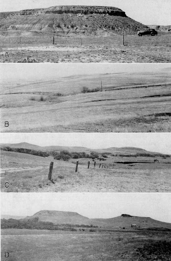
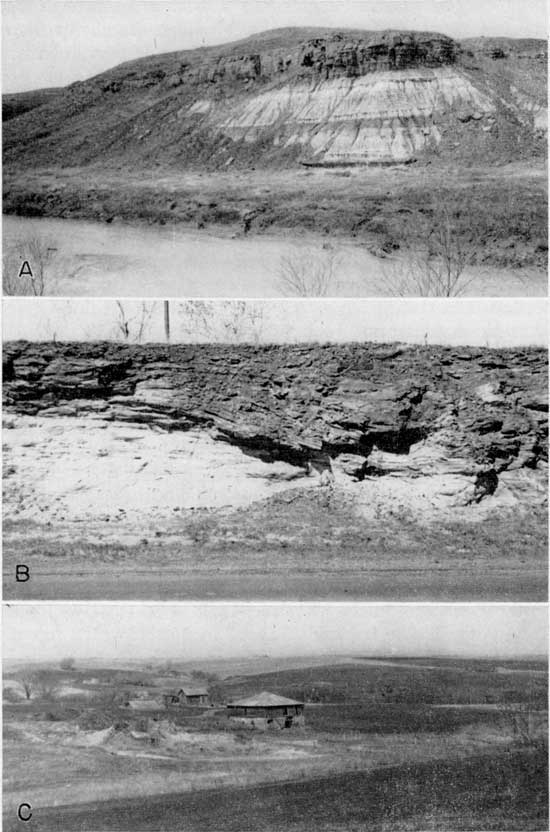
The Cretaceous lignite-bearing strata, the Dakota formation, crop out mainly in the north-central part of the State (Fig. 1). Physiographically the outcrop area of the coal-bearing formation constitutes the Smoky Hills of the dissected High Plains section of the Great Plains physiographic province (Fig. 2; Schoewe, 1949, fig. 22). The Dakota topography is in general that of a gently rolling to undulating dissected plain dotted with numerous outlying mounds or buttes; part of it, however, is characterized by flat-topped hills with steep slopes (Pl. 1). Terrace deposits, loess, glacial outwash, and till modify the Dakota topography at places and elsewhere, especially near Minneapolis in Ottawa County and near Carneiro, in Ellsworth County, the surface is strewn with numerous sandstone concretions, some of which are of very large size (Schoewe, 1949, pp. 309, 314-315). In elevation the Smoky Hills range from 1,500 to 2,000 feet above sea level. The local-relief varies greatly from place to place, reaching as much as 200 to 300 feet. In general, however, the relief is much less.
Figure 1--Map of central Kansas showing outcrop area of the Dakota formation and location of lignite mining districts.
Figure 2--Physiographic map of Kansas.
Plate 1--Dakota formation topography. A, Typical flat-top hills capped by resistant upper siltstone of the Janssen clay member, Ellsworth County (Photo by Norman Plummer). B, Gently rolling topography near Miltonvale, Cloud County. C, Topography typical of the Dakota outcrop area in Hell Creek Valley area in Lincoln and Russell counties (Photo by Norman Plummer). D, Dakota buttes at Terra Cotta, Ellsworth County.
The Smoky Hills are traversed from west to east by Republican, Solomon, Saline, and Smoky Hill rivers. Ellsworth, Minneapolis, and Wilson lie within the topographic unit. Belleville, Beloit, Concordia, Russell, and Lincoln are cities located along or near its western margin, whereas Washington, Clay Center, and Salina mark its eastern border. The Smoky Hills are served by four major railroad systems with the Atchison, Topeka, and Santa Fe Railway extending in a general north-south direction and the Union Pacific, Rock Island, and Missouri Pacific Railroads traversing the area generally in an east-west direction. Three major U.S. highways (24, 36, and 40) traverse the area in an east-west direction and U.S. 81 extends from north to south.
Outside the Smoky Hills physiographic unit no lignite crops out at any place where the Dakota formation is exposed.
Stratigraphically the Kansas lignites are of Cretaceous age and occur for the most part in the upper member of the Dakota formation (Figs. 3 and 4).
Figure 3--Dakota formation sections. A, Generalized; B, detailed section measured by Frye and Brazil in sec. 31, T. 14 S., R. 10 W., Ellsworth County, Kansas.
Figure 4--Stratigraphic sections showing position and thickness of the lignite and its relation to adjacent rocks in Kansas. A larger version of this figure is available.
The Dakota formation consists essentially of variegated clays (Pl. 2A) with minor amounts of thin siltstones and sandstone and numerous thick lenticular channel sandstones (Pl. 2B). The channel sandstones, which because of their resistance to erosion and their capping many of the hills, appear to the casual observer as the dominant and characteristic feature of the formation. These sandstones are in reality but a minor component of the formation and according to Plummer and Romary (1942, p. 327; 1947, p. 41) comprises only about one-fourth of the total thickness of the formation. Detailed studies by these men (1942, p. 327) show that the channel sandstones are not confined to any definite stratigraphic horizon within the formation but may occur anywhere within it. The Dakota formation is from 100 to 300 feet thick. As classified by the State Geological Survey (Plummer and Romary, 1942, p. 319) the Dakota formation in Kansas is made up of the Terra Cotta and Janssen clay members (Fig. 3).
Plate 2--Lithologic character of the Dakota formation. A, Variegated clays and shales overlain by massive sandstone in bluffs along Saline River north of Russell, Russell County, along U.S. 281. B, Channel sandstone along U.S. 24 west of Miltonvale, Cloud County. C, Former site of Minersville northeast of Concordia, foreground Cloud County, background Republic County. View shows at least six mine dumps, typical Dakota formation topography, and remnants of former Minersville buildings.
Terra Cotta clay member--The Terra Cotta clay or lower member consists of interbedded red, gray, brown, tan, and mottled clay, shale, and sandstone. The clay is commonly massive, mottled gray, red, and yellow, and is of the fire-clay type. Some of the clay is silty. Pellets of granular hematite, limonite, and siderite are common. The sandstones are coarse to fine-grained, lenticular, contain abundant hematitic and limonitic concretions and near the top are quartzitic. The member ranges from 70 to 220 feet in thickness, averaging about 160 feet. Lignitic material is sparsely present in the member.
Janssen clay member--Most of the lignite seams are in the Janssen clay or upper member of the formation which is from 30 to 80 feet thick. Its average thickness is 55 feet. This member consists of gray to dark-gray clay, siltstone, and fissile shale containing interbedded sandstone, lignite, and lignitic clay. Concretions of hematite, limonite, and beds of "ironstone" are common. The uppermost bed of fine-grained sandstone or siltstone, commonly gray to light gray in color, is characterized by the presence of numerous vertical channels, some of which may be worm borings and others molds of stems or roots. The lignite occurs beneath this siltstone.
The Dakota formation is overlain by the Graneros shale and underlain by the Kiowa shale and Cheyenne sandstone, formations. These formations, with the possible exception of the Dickinson, Republic, Clay, and Barton county lignite localities to be described later, do not contain lignite deposits and hence are not discussed in this report.
Figure 3A is a generalized section of the Dakota formation and is intended primarily to show the lithologic character of the formation and its subdivision into two members. The positions, thicknesses, and number of channel sandstones and lignite seams are not necessarily exact as, according to Plummer (personal communication), the channel sandstones may occur anywhere within the section and within short distances may disappear entirely. Lithologically, the Dakota formation is unpredictable. A detailed section measured by Frye and Brazil (1943, pp. 2223; Moore and others, 1951, p. 26) in sec. 31, T. 14 S., R. 10 W., in Ellsworth County showing practically a complete section of the Dakota formation is given in Figure 3B. Other detailed measured sections of the Dakota formation are shown in Figures 4, 9, and 13.
General description of lignite--Lignite is coal of the lowest rank. As used by the U.S. Geological Survey (Campbell, 1917, p. 7) lignite is "restricted to those coals that are distinctly brown and either markedly woody or claylike in appearance." Lignites grade into subbituminous coals or "black lignite" from which they are not always differentiated. Lignites are very high in moisture content, ranging from 30 to 40 percent, high in ash content, and when exposed to weathering slack or crumble very readily, a factor unfavorable for storing purposes and for long distance haulage. Lignite if not stored properly will take fire spontaneously. The heating value of lignite when compared to other grades of coal is low and does not exceed 8,300 B.t.u. Its weight or specific gravity is 1.28. In calculating coal reserves lignite is assigned a value of 1,750 tons per acre-foot (Averitt and Berryhill, 1950, p. 11).
Geographic distribution of Kansas lignite--Outcrops of lignite in Kansas are scarce. According to Mudge (1875, p. 125) lignite in the early years of mining was extracted chiefly by the stripping method suggesting that the coal was very shallow and that it probably was exposed at more numerous places than it is today. Evidences of strip-mining are very scarce. At practically all places where there is evidence of past mining, the mines, now mainly represented by dump heaps, were either of the shaft or slope type. Many of the mines had their portals stratigraphically much higher than the coal horizon in the Graneros shale or basal member of the Greenhorn limestone formation. Inquiry relative to their location reveals the fact that the lignite in many cases was discovered accidently in drilling wells for domestic water supplies.
Outcrops of lignite were observed in Cloud, Dickinson, Ellsworth, Lincoln, Mitchell, Republic, Russell, and Washington counties. In addition, lignite has also been reported to have cropped out in Hodgeman County although search for the coal at the described localities proved fruitless. At the two places where the lignite was said to have cropped out and where it was reported to have been mined, alluviation had buried the lignite outcrops under a fill of river sediment to an estimated depth of 10 to 15 feet. Test holes for oil in the vicinity, however, reveal the presence of lignite at a number of places in Hodgeman and Ford counties. Lignite has also been mined in Clay, Jewell, and Mitchell counties and reported to occur in Barber, Barton, Ford, McPherson, Osborne, Ottawa, Rice, and Saline counties. It is evident from field studies that the lignite is not continuous over wide areas as is the bituminous Pennsylvanian coal of eastern Kansas. The geographic distribution of the lignite outcrop areas, location of mines, and reported occurrences are shown on Figure 1.
Stratigraphic position and contact rock--Most of the lignite occurs in the upper part of the Dakota formation, a fact established first by Hay in 1887 (1889, pp. 6, 7). Earlier Mudge (Hay, 1885, p. 111) and St. John (1887, p. 143) had suggested that the various seams of lignite then recognized at the then known localities constituted a single stratigraphic horizon or zone. Field evidence indicates that most of the lignite occurs within the uppermost 25 feet of the formation. South of Wilson in Ellsworth County in the W sec. 6, T. 15 S., R. 10 W., six lignite seams occur in the uppermost 17 feet of the Dakota formation, whereas on the Boal farm in the SE sec. 19, T. 4 S., R. 1 W., Republic County, the lignite is found 25 feet 3 inches below the top of the formation. In the NW cor. sec. 15, T. 15 S., R. 10 W. in Ellsworth County only 2 1/2 feet of black shale and ironstone separate the 12-inch lignite seam from the Graneros shale. It is now known that not all the lignite seams are confined to the uppermost part of the Dakota formation. In the SE sec. 24 and the NE sec. 25, T. 16 S., R. 1 E. in Dickinson County, 3 miles south and 1 to 1 1/2 miles west of Elmo, a 22-inch seam of lignite is either in the Terra Cotta clay member of the Dakota formation or in the uppermost part of the Kiowa shale. Immediately below the lignite is a dark-gray to black clay shale containing numerous large and well-developed selenite crystals as well as some fragments of pyritized logs. Overlying the lignite is a cream to yellowish silty shale or thin-bedded siltstone which on weathering breaks up into small chip stones. This unit, which is 30 inches thick, is overlain by an 18-inch thin-bedded siltstone. Since the top of the Kiowa shale is not always readily distinguishable from the basal part or clay of the Dakota formation except by ceramic or other tests that show the mineralogical characteristics of the two (Plummer and Romary, 1942, pp. 331-332), it cannot be stated with certainty whether the Dickinson County lignite is in the Dakota or in the Kiowa shale. It can be stated, however, that the lignite does not occupy its normal position in the upper part of the Dakota formation as observed at most other localities. About a mile east of the lignite outcrop Permian strata crop out at the surface. Plummer and Romary (1942, p. 329) in presenting a generalized section of the Dakota formation in north-central Kansas describe a lignite zone near the base of the Terra Cotta clay member as follows:
2 Clay with silt, gray to dark gray, or fine sandstone bands, lignite and fossil leaves common. In some sections portions of this bed are shale or thin-bedded clay. A highly lignitic, darker band commonly occurs toward the bottom, and pyrite, also. This bed is mostly a refractory fireclay; and, unless yellow stain is marked, samples fire to ivory or cream colors, [thickness] 5.0 to 30.0 feet.
Underlying their zone 2 is a siltstone and fine sandstone up to 20 feet thick. Zone 1, however, is missing in places. At such places zone 2 rests directly on Kiowa shale from which it, in some cases, is indistinguishable from the Dakota clay or shale except by ceramic or other tests that show the mineralogical characteristics of the two. Selenite crystals which are typical of the Kiowa shale are not mentioned as being present in zone 2 described by Plummer and Romany. The occurrence of lignite in the basal part of the Terra Cotta member is indicated in a section measured by Plummer in Ellsworth County (Moore and others, 1951, p. 26; Fig. 9). It may be, therefore, that the Dickinson County lignite corresponds to Plummer and Romary's zone 2 and hence is in the basal part of the Terra Cotta clay member of the Dakota formation. For purposes of this report the lignite is assigned to the lower Dakota formation. Other possible occurrences of lower Dakota lignite may be found in Barton, Clay, Republic, and Stafford counties.
At the outcrop, the lignite occurs within shale, between layers of sandstone or siltstone, or is overlain by siltstone and underlain by shale. Where observed most of the lignite is overlain by siltstone. Along the bluffs of Smoky Hill River in the NE sec. 6, T. 15 S., R. 14 W., Russell County, the coal is entirely within the shale.
Thickness--Where seen, the lignite is nowhere greater than 25 inches in thickness. At most places it is much thinner. On the basis of published data seams of lignite as much as 40 inches thick have been mined. Since no lignite has been mined commercially since about 1940 no deep or mined lignite was seen. Lignite from 3 to 12 feet thick has been reported to me to underlie southern Hodgeman and northern Ford counties. Field evidence seems to indicate that the thickness of the lignite seams varies greatly from place to place and in short distances and that the coal is, for the most part, spotty and discontinuous. The thicknesses of the lignite are summarized by counties in Table 1.
Table 1--Summary of thickness of lignite and depth to coal where mined.
| County | Thickness range at outcrops, inches |
Thickness in mines, inches |
Reported thickness, inches |
Depth to coal where mined, feet |
|---|---|---|---|---|
| Barton | 12 | |||
| Clay | 18 | |||
| Cloud | 2-25 | 24 | surface-110 | |
| Dickinson | 3-22 | |||
| Ellsworth | 2-20 | 12-36 | 20-75 | |
| Ford | 48-96 | |||
| Hodgeman | 36 | 36-144 | 15-25 | |
| Jewell | 30-36 | 150-160 | ||
| Lincoln | 24 | 15-26 | 50-60 | |
| Mitchell | 3 | 14 | 25 | |
| Ottawa | 6 | |||
| Republic | 16-48 | 25 | surface-75 | |
| Russell | 9-24 | 11-40 | surface-75 | |
| Washington | 4-14 | 14-18 | surface-30 |
Number of seams--The lignite occurs in more than one seam. South of Wilson in Ellsworth County in the bluffs along Saline River in both Ellsworth and adjoining Russell counties there are as many as six coal seams varying from 2 to 12 inches in thickness, all within a vertical distance of 17 feet. Elsewhere, it is not unusual for a single seam to be separated by a 2 to 4 inch silt or clay parting.
Physical and chemical characteristics--Most of the lignite seen in the field is composed of extremely matted highly carbonized coal material imbedded or intermingled with a large amount of silt and dark clay. Within the woody material are found streaks of shiny jet-black dense brittle amorphous coal. The lignite also contains pyrite in the form of small crystals, nodules, and pyritized woody fragments. According to reports of those having used the lignite for fuel, the lignite yields a large quantity of white ash when burned and emits considerable sulfurous odors. The coal emits no soot and gives off a fair degree of heat. Because of the high moisture content the coal or lignite slacks readily when exposed to the atmosphere. On weathering the lignite assumes a brownish color and a more or less foliated or papery appearance. At a few places, especially along the east bluff of Smoky Hill River in the NE sec. 6, T. 15 S., R. 14 W. south and west of Russell, the lignite is jet black instead of brownish and has the appearance of true coal. The seam here also is essentially free from impurities of clay and silt except for small streaks of pyrite crystals. This coal seam is from 15 to 24 inches thick and is over and underlain by dark-gray to black lignitic shale. A sample of coal received and reported to have come from one of the test holes sunk in Hodgeman County is essentially similar to the Smoky Hill coal of Russell County. Because of the scarcity of outcrop, the thinness of the lignite seams, the highly weathered nature, and the impure character of the coal where seen, no good description of bedding and other structural features can be given. At most of the outcrops the lignite seems foliated and when pried off breaks into irregular masses suggesting poor bedding and jointing. The Smoky Hill deposit south and west of Russell when sampled broke off into small more or less rectangular shaped pieces. That some of the mined coal, especially where it measured several feet in thickness, may have had good bedding is suggested by a report in the Jewell County Republican, a weekly newspaper, in 1904 that a block of coal measuring 36 by 36 by 36 inches and weighing 900 pounds had been taken from the 160-foot deep mine in the NW sec. 34, T. 4 S., R. 7 W. about 3.25 miles east of Jewell. In the Black Wolf area in sec. 19, T. 15 S., R. 9 W., in sec. 24, T. 15 S., R. 10 W. in Ellsworth County, and in the Dickinson County area south and west of Elmo in sec. 24, T. 16 S., R. 1 E. the lignite is seen to dip considerably (Pl. 5A). As previously indicated the lignite is, thin and as far as could be ascertained from field observations the seams vary considerably in thickness in short distances and seem to be spotty and discontinuous. However, outcrops of the lignite are very scarce undoubtedly owing to the thinness of the seams and also to the fact that the containing strata are easily weathered and eroded accompanied by excessive slumping. Where formerly mined, outcrops of the lignite are conspicuously lacking. Many of the shafts have their portals in strata stratigraphically much higher than the Dakota formation, probably because most of the coal was discovered accidentally while drilling for water supplies. Table 1 shows the depth to the coal where formerly mined.
Proximate analyses--Sixteen samples of the lignite were collected from seven localities. Because of the character of the overburden, sampling was done by using a 5-inch auger and boring into the coal seam from a horizontal position. Before augering from 2 to 3 feet of the face of the coal was removed, thereby removing most, if not all, of the weathered lignite. Holes then were bored horizontally into the newly exposed coal to a depth of 7 to 35 inches, the material collected in quart jars, and immediately sealed. Where the coal was sufficiently thick the holes were vertically one above the other (Fig. 5A) with the top of the uppermost hole from 3 to 5 inches below the top of the coal seam. In some cases the holes were arranged as shown in Figure 5B. The samples were analyzed in the chemical laboratories of the State Geological Survey under the direction of Russell T. Runnels. Proximate analyses of the lignite samples are given in Table 2. As compared to the heating value of the bituminous coals of eastern Kansas (Schoewe, 1946, pp. 30-32) the Kansas Cretaceous lignites are decidedly inferior. The analyses presented in Table 2 probably do not represent the average proximate analyses and heating value of the coals that formerly were mined which are believed to have had a higher B.t.u. value.
Figure 5--Diagram showing arrangement of sample holes where lignite samples were obtained by augering horizontally into the coal seam.
Table 2--Proximate analyses, sulfur content, and heating value of the Cretaceous ligitite coals of central Kansas (Analyses by Russell T. Runnels in the State Geological Survey laboratories).
| County | Location | Sample no. |
Form* | Moisture, percent |
Ash, percent |
Volatile, percent |
Fixed carbon, percent |
Sulfur, percent |
B.t.u. |
|---|---|---|---|---|---|---|---|---|---|
| Ellsworth | 6-15-10W | 1,2,3 | A | 13.08 | 35.19 | 27.17 | 24.56 | 1.00 | 3,968 |
| B | 40.48 | 31.25 | 28.25 | 1.15 | 4,565 | ||||
| C | 52.52 | 47.47 | 1.93 | 7,671 | |||||
| Russell | 4-15-11W | 5,6,7 | A | 10.18 | 56.19 | 20.29 | 13.34 | 0.48 | 2,156 |
| B | 62.55 | 22.59 | 14.85 | 0.53 | 2,400 | ||||
| C | 60.35 | 39.67 | 1.42 | 6,114 | |||||
| Russell | 21-13-12W | 8,9 | A | 14.07 | 14.80 | 36.85 | 34.28 | 1.97 | 6,706 |
| B | 17.22 | 42.88 | 39.89 | 2.29 | 7,803 | ||||
| C | 51.80 | 48.19 | 2.77 | 9,428 | |||||
| Russell | 6-15-14W | 10, 11, 12 | A | 10.68 | 19.23 | 32.60 | 37.49 | 6.28 | 7,290 |
| B | 21.52 | 36.49 | 41.97 | 7.03 | 8,162 | ||||
| C | 46.51 | 53.48 | 8.95 | 10,401 | |||||
| Lincoln | 32-13-7W | 13,14 | A | 12.13 | 39.82 | 24.87 | 23.13 | 1.02 | 3,600 |
| B | 45.34 | 28.31 | 26.33 | 1.16 | 4,099 | ||||
| C | 51.81 | 48.19 | 2.12 | 7,500 | |||||
| Republic | 24-4-3W | 15 | A | 13.9O | 38.91 | 24.91 | 22.28 | 1.01 | 3,469 |
| B | 45.19 | 28.93 | 25.87 | 1.17 | 4,029 | ||||
| C | 52.78 | 47.21 | 2.14 | 7,351 | |||||
| Dickinson | 24-16-1E | 16 | A | 6.03 | 70.74 | 12.33 | 10.87 | 4.45 | 1,105 |
| B | 75.30 | 13.12 | 11.57 | 4.73 | 1,176 | ||||
| C | 17.43 | 15.36 | 6.29 | 4,763 | |||||
| A, Air dry basis; B, moisture free basis; C, moisture and ash free basis. | |||||||||
None of the mines are in a condition to enter; thus no underground samples of lignite were obtained. All samples of lignite collected were secured from surface outcrops and although as much of the weathered material was removed before sampling as possible, it is questionable whether the lignite obtained was entirely unaltered. Several analyses of lignite were made many years ago. Since, however, the methods employed in making these early analyses are not known, it is not safe to compare them with the more recent analyses presented herewith. They are included, however, for historical purposes. In 1872 Saunders (1873, p. 390) made an analysis of lignite obtained from the Kansas, Pacific Railroad (Union Pacific Railroad) along Wilson Creek in Ellsworth County (Table 3). Bailey (1889, p. 49) made an analysis of lignite obtained from Minersville north of Concordia in Cloud County in 1888 (Table 4). Blake (1889, p. 46), using the same sample analyzed by Bailey, determined the evaporative power of the lignite (Table 5).
Table 3--Analysis of lignite from Wilson's Creek, Ellsworth County, Kansas (Saunders, 1873, p. 390).
| Constituent | Percent |
|---|---|
| Water | 7.50 |
| Combustible gases, cubic feet per pound | 2.33 |
| Illuminating power | low |
| Amount of tar | small |
| Sulphur | 1.63 |
| Coke | 68.75 |
| Ash | 9.50 |
| Rate of combustion in open air | fast |
| Volatile matter | 31.25 |
| Fixed carbon | 59.25 |
Table 4--Analysis of lignite from Minersville, Cloud County, Kansas (Bailey, 1889, p. 49).
| Constituent | Percent |
|---|---|
| Water | 13.70 |
| Volatile | 46.14 |
| Fixed carbon | 28.52 |
| Ash | 11.64 |
| Sulphur | not tested for |
Table 5--Evaporative power of Minersville lignite, Cloud County, Kansas (Blake, 1889, p. 46).
| Pounds water evaporated per pound of coal |
Duration of burning, seconds |
Calories, gram-degrees centigrade |
||
|---|---|---|---|---|
| Correction on apparatus | Correction | |||
| 10 percent | 30 percent | 10 percent | 30 percent | |
| 9.90 | 11.68 | 135 | 5,316 | 6,273 |
Uses--Even though of inferior quality as compared to the coals of the eastern part of the State, the lignite served a useful purpose to the people of central Kansas before 1900 in the days when better types of fuel such as natural gas, oil, commercial fuels as butane etc., and shipped-in better grades of bituminous coal were available to them. A good illustration of how the mining of the lignite affected the economy of central Kansas is shown by the fact that in Lincoln County farmers and others in the early 1890's had to haul coal from shipping points as much as 10 to 20 miles distant and pay from $7.00 to $12.00 a ton for the coal. When the lignite was put on the market, shorter distances for hauling the fuel were involved and the price per ton of coal at the railroad yards dropped immediately to $5.00. The lignite sold at $3.25 per ton (Brown, 1896, p. 77). Another instance of the value of the lignite is reported by Young (Young and Allen, 1925, p. 39) as follows: "During the shortage of coal caused by a protracted strike in 1919 in the operating districts from which coal is commonly obtained, some coal was mined from the Cretaceous deposits and served a very useful purpose of ameliorating the condition caused by a fuel shortage in a cold season." Not only was the lignite used as a domestic fuel but it was also employed by the railroads of the lignite-bearing country to fire their locomotives (Malin, personal communication; Hutchinson, 1871, p. 63; Kansas Daily Tribune, Lawrence, Aug. 1, 1868). The fact that more than 300,000 tons of lignite valued at approximately $1,000,000 was mined in Kansas testifies to its economic importance to central Kansas. While it is true that the lignite deposits of Kansas at the present time are not to be considered commercially minable, nevertheless they should not be considered valueless. Fuel shortages due to protracted strikes in the bituminous coal areas, transportation breakdowns, depletion of oil and gas reserves, labor difficulties in the manufacture. of synthetic fuels, and unusually high prices of natural fuels are not impossible in the future. Should such happen the mining of lignite in central Kansas may again be revived. Of much greater importance, however, is the fact that experiments on the liquefaction and hydrogenation of coals show that lignites are especially amenable to those processes and that the lignites are a potential source of future gasoline and other liquid fuels. It is on this basis that the Kansas lignites may be considered as marginal reserves.
Without doubt lignite was used for fuel just as soon as it was discovered by the settlers in the coal-bearing counties of central Kansas. According to Wing (1930, p. 43) lignite was mined at Minersville in Cloud and Republic counties as early as 1855. The first lignite mined was obtained by stripping methods. This was especially true in the early 1870's (Mudge, 1875, pp. 124-125). Apparently mining by stripping did not persist very long as most published reports list the lignite mines as drift or shaft mines. The last lignite mined in Kansas and officially reported was for the year 1940 (Delplace, 1941, pp. 54-55).
The mines at their best were crude affairs when compared to modern coal mines. Coal mine inspectors complained of the unsatisfactory conditions prevailing in the mines of the western counties. In Cloud County (Gallagher, 1894, p. 19) where much of the mining was done, shaft mines had no second openings, the ventilation in the mines was poor, places to land the cages on top were lacking as well as gates at the landings. Horse power was used to lift the cages which were held in place by the gin horses while the cars were being pulled off the cages. Ordinary precautions for the safety of the men were disregarded or not considered at all. Since most of the mines were operated only in fall and during the winter months, water collected in the mines during the idle months. If later the mine was to be used again and found not to be in good shape, another hole in the ground near by was sunk and the new mine opened, using the old shaft for an air shaft. A small scale and a dugout comprised the improvements on top at the mine (McGrath, 1898, pp. 67-68). Since all the work in the mines was done by man power, entries in many instances were less than 3 feet high. Many of the shafts were no larger than 4 by 4 feet.
Each one of the mining districts was small and limited to a few mines each. The mines too were small affairs employing in each no more than 10 to 15 men of whom 8 to 12 were classified as miners. As far as known there were only two mining districts in central Kansas where mining of the lignite was a major operation. About 6 miles northeast of Concordia in Cloud County was Minersville, a small town consisting of several houses, a store or two, a post office, and a hotel. Its inhabitants were primarily associated with the mining industry. Minersville was located chiefly in the NE sec. 2, T. 5 S., R. 3 W. in Cloud County and extended across the county line into sec. 35, T. 4 S., R. 3 W., Republic County. A second mining community was formerly located in Russell County, 5 to 6 miles south and 2 1/2 miles east of Dorrance or 4 miles south and 3 1/2 miles west of Wilson in Ellsworth County. The exact location of this mining community is in secs. 3 and 4, T. 15 S., R. 11 W., Russell County.
None of the lignite mines had railroad connections. The coal was hauled away in wagons to distances as much as 75 miles from the mines. The last lignite mine was opened in 1930 by a Mr. Curtis in the now abandoned Minersville district in the NE sec. 2, T. 5 S., R. 3 W. (Wing, 1930, p. 44). This mine was being cleaned and made ready for operation at the time of Whitla's visit in August 1939 (Whitla, 1940, p. 34) and during the following mining season produced 50 tons of coal, the last to be reported officially from any of the lignite mines in central Kansas.
Production statistics of lignite are incomplete. The earliest production figures found for lignite are for the year 1875 when both Cloud and Russell counties reported an output of 500 tons each or a total of 1,000 tons. The peak of production was reached in 1890 and 1891 when 26,192 and 28,352 tons of lignite were produced respectively. In 1890 production was reported from seven counties, Cloud, Ellsworth, Lincoln, Russell, Republic, Jewell, and Mitchell. Most of the lignite mined came from Cloud County whose cumulative production amounted to 130,753 tons. Russell County produced 44,808 tons, Ellsworth County 41,229 tons, Lincoln County 39,493 tons, Republic County 30,790 tons, Jewell County 9,963 tons, and Mitchell County 3,148 tons. As far as the reports of the State Coal Mine Inspectors are concerned no lignite was mined between the years 1907 and 1935. Last production reported is for Cloud County in 1940 when 50 tons were produced. As no records were kept in former years as to the amount of coal produced by the miners for their own use, (Brown, 1896, p. 65) and since it is questionable whether all the smaller mines reported their production the 300,184 tons of lignite reported represent the minimum production of lignite. Published production statistics of the lignite-producing counties of central Kansas are summarized in Table 6. Annual production statistics of lignite for each county are presented on subsequent pages.
Table 6--Summary of cumulative Kansas Cretaceous lignite production from 1875 to 1940 and original reserves, by counties, in tons. Reserve estimates are stated to three significant figures or less.
| County | Production officially reported |
Original reserves | Total | ||
|---|---|---|---|---|---|
| Marginal (measured) |
Alleged | ||||
| Less than 3 feet thick |
More than 3 feet thick |
Less than 3 feet thick |
|||
| Clay | 400,000 | 400,000 | |||
| Cloud | 130,753 | 5,300,000 | 5,300,000 | ||
| Dickinson | 500,000 | 500,000 | |||
| Ellsworth | 41,229 | 8,800,000 | 8,800,000 | ||
| Hodgeman and Ford |
105,000,000 | 105,000,000 | |||
| Jewell | 9,963 | 7,400,000 | 22,400,000 | 29,800,000 | |
| Lincoln | 39,493 | 10,500,000 | 10,500,000 | ||
| Mitchell | 3,148 | 500,000 | 500,000 | ||
| Republic | 30,790 | 8,200,000 | 7,900,000 | 16,100,000 | |
| Russell | 44,808 | 12,700,000 | 7,900,000 | 20,600,000 | |
| Washington | 700,000 | 700,000 | |||
| Total | 300,184 | 55,000,000 | 121,000,000 | 22,400,000 | 198,000,000 |
Because of the variable nature of the Kansas lignite in regard to thickness, the scarcity of outcrop, and the general lack of information relative to the coal, it is extremely difficult to estimate the quantity of lignite unmined. On the basis of the standard used by the U.S. Geological Survey Fuels Branch in calculating lignite reserves, Kansas is essentially without lignite reserves. Except for local pockets, practically all the lignite mined in the State was 30 inches or less in thickness, the minimum thickness considered by the Fuels Branch as lignite reserve coal.
Marginal lignite reserves--The unmined Kansas lignites, although too thin to be classified as true measured reserves, are here considered marginal lignite reserves (1) because of their shallow depth and therefore ease to which they may be subject to processes converting them into possible liquid fuels and gasoline and (2) the lignites may again under adverse economic conditions be resorted to, as in former years, as an emergency fuel. All reserves in this report are considered as original lignite reserves and are to be compared to the proved original reserves (measures of the U.S. Geological Survey) of eastern Kansas. No attempt is made to estimate or consider potential reserves. The standard and methods adopted by the State Geological Survey of Kansas in estimating the bituminous coal reserves of the eastern part of the State (Abernathy, Jewett, and Schoewe, 1947, pp. 13-14; Schoewe, 1946, pp. 40-41) are not entirely satisfactory or applicable to the study of the lignite reserves of central Kansas. For the purpose of estimating the lignite reserves of Kansas the following guide based primarily on methods employed by the Fuels Branch of the U.S. Geological Survey in calculating original reserves has been selected (mimeographed suggested rules for calculating and reporting coal reserves, U.S. Geological Survey, Fuels Branch, pp. 3-4).
All reserve estimates are stated to three significant figures or less.
The original lignite coal reserves of coals less than 3 feet thick prior to mining operations of the central Kansas counties considered in this report total 55,000,000 tons (Table 6).
Alleged lignite reserves--In addition to the known thin seams of 30 inches or less in thickness, several areas in the State are reported to be underlain by lignite more than 30 inches thick. The lignite of such areas which are not associated with any mining activity but whose presence or occurrence is based on nontechnical reports and suggested by broad geologic field relationships are here designated as alleged lignite reserves. Alleged reserves of lignite are thought to underlie parts of Hodgeman, Ford, Russell, and Republic counties. Such alleged reserves total about 121,000,000 tons to which slightly more than 22,000,000 tons should be added for similar coals in Jewell County less than 30 inches thick, making thus a total of approximately 143,000,000 tons alleged lignite reserves (Table 6).
The grand total of all original lignite reserves amounts to 198,000,000 tons, an amount reduced by mining by only 300,000 tons. Table 6 summarizes the lignite reserves of central Kansas. Detailed data concerning the reserves are to be found under the various county discussions.
Recoverable coal--All the lignite reserves given are original reserves or coals that are underground and are not to be considered as coals all of which are recoverable. At the present time it is not known precisely how much coal can be extracted or recovered from any mine or mining district in the United States. What may be recoverable coal in one locality is not necessarily recoverable coal in another mining district. As an illustration of this it may be cited that the bituminous coal mined in the Burlingame-Osage City area is sold as mine-run coal. The coal coming from the mines is not washed or treated in any way. All coal mined is sold and therefore is recoverable coal. A little farther to the southeast in the Cherokee coal country of southeastern Kansas the coal before being sold is washed, graded, and treated, thus reducing the actual mineral tonnage by about 25 percent. Hence only 75 percent of the coal mined is recoverable. Furthermore the amount of coal that can be recovered will depend upon the type of mining that is employed--the longwall system versus the room-and-pillar method and the stripping method as against underground mining. Other factors such as the structure of the coal beds also affect the percentage of the total coal that may be recovered in mining. Averitt and Berryhill (1950, p. 8) of the Fuels Branch of the U.S. Geological Survey in estimating the recoverable coal in the United States assume a recovery of 50 percent of the coal in the ground and are of the opinion that this rate will be maintained in the future. On the assumption that 50 percent of the lignite estimated to be underground is recoverable, Kansas then has approximately 27,000,000 tons of recoverable marginal lignite reserves 30 inches or less in thickness and an additional 72,000,000 tons if the alleged reserves are considered, making a grand total of about 99,000,000 tons of recoverable lignite reserves of all kinds. It should be stated in this connection that the State Geological Survey of Kansas is interested primarily in the estimates of original coal reserves--that is, coal underground--and that it is for the coal industry to decide or determine how much of that coal is recoverable under present-day conditions. Obviously recoverable coal estimates must vary from time to time depending upon economic conditions and new advances in coal technology, two factors which we cannot foresee or predict for the future.
Next page--County Data and References
Kansas Geological Survey, Coal Resources of the Cretaceous System
Placed on web Jan. 16, 2009; originally published in February 1952.
Comments to webadmin@kgs.ku.edu
The URL for this page is http://www.kgs.ku.edu/Publications/Bulletins/96_2/index.html