![]()
Prev Page--Uses || Next Page--References
Volcanic Ash Resources by Counties
All Kansas volcanic ash deposits of potential commercial value of which we have knowledge are described or listed under the following county headings. Most of these deposits were visited in the field and sampled by us during the course of this investigation, but a few localities are included on the basis of data reported to us by land owners and staff members of the Geological Survey. One hundred sixty deposits of volcanic ash in 39 counties are listed. The available data indicate that the tonnage of usable ash in Kansas exceeds 20 million tons although detailed estimates of ash reserves are not given for most individual localities described in the county sections. The economically usable tonnage of any individual deposit is affected by many factors such as transportation facilities, nearness to market, overburden, texture, thickness, color variations, etc.; therefore any locality should be considered in the light of the particular development under consideration. The numbers enclosed in parentheses after many of the locations described refer to laboratory numbers of the Geological Survey's ceramics division and are used in the several tables included in this report.
Chautauqua County
Although a volcanic ash deposit was reported in Chautauqua County by Landes in 1937, efforts to relocate it were unsuccessful until 1950 when, with the aid of local residents, the deposit was found to occur in the NW NW SE and the NE NE SW sec. 9, T. 34 S., R. 12 E. (CQV-1) instead of in the NE SW sec. 9, T. 34 S., R. 13 E. as reported earlier. Ash is exposed on both sides of the north-south road and an auger hole in the field to the east of the road penetrated 4 feet of fresh ash overlying a bed of clay. Petrographic examination shows the ash to be the Pearlette bed of Pleistocene age. Field inspection indicates that the ash deposit underlies at least 10 acres.
Clark County
Six sections in the north-central part of Clark County contain deposits of Pearlette volcanic ash. Smith (1940, p. 200) summarized the occurrence of volcanic ash in the county and subsequently three deposits have been visited and sampled by us. A small ash pit has been opened in the SE cor. sec. 23, T. 30 S., R. 24 W. (CLV-1); and auger holes bored in the pit and to the south of it show the deposit to exceed 11 feet in thickness. Of this thickness 9.0 feet is fresh relatively uncontaminated ash. The deposit is known to be at least 400 feet long but the limits were not determined.
Smith (1940) lists outcrops of volcanic ash along the sides of three small valleys tributary to Bluff Creek in secs. 11, 12, and 13, T. 30 S., R. 23 W. A series of auger holes bored by Harley Holliday in the NE SW sec. 12, T. 30 S., R. 23 W. (CLV-2) penetrated fresh, relatively pure ash that ranged in thickness from 2 to 6 feet. Smith (1940, p. 200) described a small exposure on the side of a small draw in the NW cor. sec. 19, T. 30 S., R. 23 W. and another small exposure on both sides of the small draw in the north-central part of sec. 24, T. 30 S., R. 24 W.
Comanche County
Four volcanic ash deposits were visited and sampled in the field in Comanche County, and one additional deposit was reported to us by the State Highway Department. Pearlette volcanic ash has been mined in the SE NE sec. 12, T. 31 S., R. 18 W. (CMV-1). A maximum of 13 feet of ash was determined to occur at this locality by measuring surface exposures and auguring in the floor of the pit. Small surface exposures indicate that the bed extends a linear distance of at least 500 feet. The Kansas Highway Department has estimated that this deposit contains 3,000 cubic yards of recoverable ash. Throughout the entire 13-foot thickness the ash is fresh and relatively free of impurities.
Slightly weathered volcanic ash is exposed in a small pit in the Cen. W2 sec. 7, T. 31 S., R. 17 W. (CMV-4). A thickness of 8 feet was measured on the face of the abandoned pit, but the total thickness was not determined. An early estimate by the Highway Department places the reserves at 4,000 cubic yards of recoverable ash in this immediate area.
About 1.5 feet of Pearlette volcanic ash is exposed in the NW SW sec. 24, T. 32 S., R. 17 W. (CMV-2) and auguring at the base of the exposure revealed a total thickness of 6 feet of ash. The upper 5 feet is relatively clean ash, but the lower 1 foot is discolored and possibly impure. The overburden ranges from 3 to 4 feet in thickness.
A bed of Pearlette volcanic ash 2.5 feet thick was found in the NW SE sec. 29, T. 32 S., R. 16 W. (CMV-3). The overburden at the point sampled is 2 feet thick, and the ash is underlain with clay.
Decatur County
Three deposits of volcanic ash, two of which are listed by Landes (1928, p. 20), have been reported in Decatur County. The first of the two deposits, in the SE SW sec. 28, T. 4 S., R. 29 W. (DRV-1), was visited and sampled during the course of this investigation; it consists of 5 feet of slightly altered clean ash overlain by a maximum of 15 feet of cemented sand, silt, and gravel. The hard nature of the overburden, however, would make exploitation of the deposit difficult. The second deposit listed by Landes occurs in sec. 12, T. 4 S., R. 30 W. A deposit consisting of 3.2 feet of fresh volcanic ash containing some coarse sand and overlain by a maximum of 5 feet of Ogallala mortar beds was sampled in the NE NE sec. 15, T. 3 S., R. 30 W. (DRV-2). The ash at this locality has been assigned tentatively to the Reager ash bed on the basis of its petrographic characteristics.
Dickinson County
One foot of Pearlette volcanic ash is exposed in a cut along the north side of a road and occurs between cemented conglomerate beds and interbedded in silty clays along the S. line SW SW sec. 26, T. 14 S., R. 2 E. The ash is relatively free of impurities but is slightly weathered. The total extent of the deposit seemingly is limited.
Ellis County
Ellis County contains volcanic ash in two known deposits. One of these is a thin but relatively widespread lentil of Pearlette volcanic ash in the SE SE sec. 17, T. 14 S., R. 19 W. (ESV-1). In this area the ash is about 3.5 feet thick, is fresh, and relatively free of impurities. The State Highway Department has mined some of the ash in the southeast corner of the section and the Department estimates the reserves of ash in the area to be approximately 30,000 cubic yards. At the pit the overburden is 10 feet or more in thickness and consists of clay, silt, and fine sand with some volcanic ash.
Another deposit of volcanic ash occurs in the SW NW (ESV-2) and in the NW SW (ESV-3) sec. 5, T. 13 S., R. 19 W. In this area a maximum of 10.5 feet of volcanic ash with an overburden of approximately 8 feet was found by auguring, and as the ash crops out in the adjacent sec. 6, this is probably a large deposit. The ash penetrated by auguring is rather fresh and free of excessive contaminants. Both of the Ellis County deposits are underlain by clay.
Ellsworth County
Three deposits of Pearlette volcanic ash, two of which were visited and sampled by us, are known to occur in Ellsworth County. A maximum thickness of 13.5 feet is exposed in the SE NW sec. 28, T. 16 S., R. 7 W. (ELV-24) where the ash crops out along a relatively steep bank on the east side of a creek. The lower 9.5 feet of this bed is light-colored clean ash but the upper part contains some streaks of silt and clay. At least 2,500 tons of ash was determined, on the basis of three auger holes put down to the east of the exposure, to occur in this area but the extent of the deposit may be much larger.
Another deposit was sampled in the N2 SW sec. 22, T. 15 S., R. 7 W. (ELV-2) along a cut of the Union Pacific Railroad. At this locality 9 feet of relatively fresh clean ash was penetrated by auguring on the south side of the tracks and indications of ash were also observed for some distance to the north of the tracks.
Relatively impure ash is exposed at a third locality in the Cen. S2 sec. 29, T. 15 S., R. 9 W.
Gove County
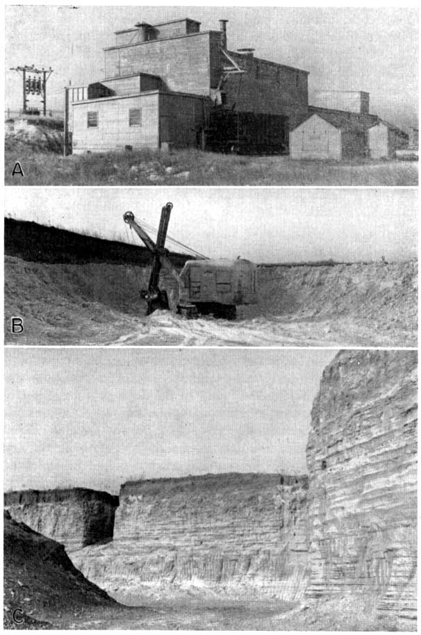
The minable reserves of Pearlette volcanic ash in Gove County substantially exceed 100,000 tons. Landes (1928, p. 21) described a deposit in the NE SW sec. 21, T. 13 S., R. 26 W. (GV-1) (Pl. 3A) and reported an estimate of available ash of at least 60,000 tons. Several carloads of ash had been shipped from a pit at this location prior to the writing of his report in 1928. Auger holes in the area have served to increase the known maximum thickness from 16 feet reported by Landes to 17 feet and have confirmed or expanded his earlier estimate of available tonnage. Throughout most of the thickness of the bed, the ash is fresh and free of impurities, although scattered concretions occur at a few places in the bed and the lower 4 to 6 feet contains yellowish streaks. The deposit is underlain by chalk.
In the area adjacent to Smoky Hill River in the south-central part of Gove County, four other deposits of Pearlette volcanic ash were examined. Fourteen feet of ash with a silt, sand, and gravel overburden ranging from nil to 15 feet in thickness is exposed along a tributary valley entering the Smoky Hill from the south in the SW SE sec. 25, T. 15 S., R. 28 W. (GV-2). The ash is nearly white in color and relatively clean. In some places a thin layer of clayey silt and sand with snails occurs between the ash and the underlying chalk but at other places the ash rests directly on Niobrara chalk.
Pearlette ash 13.5 feet thick was found to occur in the SW NW sec. 17, T. 15 S., R. 27 W. (GV-3) where the upper 5 feet is exposed and the remaining 8.5 feet was penetrated by auguring. The exposure occurs in the northeast bank of a southeastward-trending draw which is tributary to Smoky Hill River. The deposit contains scattered flaky pieces of Niobrara chalk and some silt and sand and rests on the chalk.
In the Cen. NE sec. 14., T. 15 S., R. 28 W. (GV-5) 6 feet of ash is exposed along both sides of a deep draw just below a farm pond dam. The overburden here ranges from 1 to 10 feet in thickness.
A small deposit of ash occurs in the E2 NW sec. 33, T. 15 S., R. 27 W. (GV-4) where 6 feet of ash is exposed on a narrow spur, but the width of the deposit is only about 50 feet.
Another small discontinuous deposit of ash is present in the NW NE sec. 26, T. 15 S., R. 29 W., where thin Pearlette ash occurs directly in contact with the Niobrara chalk and interbedded in deposits of the Meade formation. The maximum thickness is 4 feet, but along most of the exposure the thickness of the ash ranges from a featheredge to 2.5 feet.
Graham County
Only one deposit of Pearlette volcanic ash is known to occur in Graham County. This deposit has been mined in a small pit exposing 6 feet of clean fresh ash on the north side of a draw in the NE_ SW_ sec. 11, T. 8 S., R. 25 W. (GMV-l). The upper 3 feet contains nodules and minute grains of calcium carbonate; 3 feet of impure ash containing appreciable quantities of silt and sand overlies the 6 feet of fresh ash. The overburden, including the impure ash, has a maximum thickness of 12 feet.
Grant County
Substantial reserves of Pearlette volcanic ash are known to occur in the southeastern part of Grant County. These deposits were reported in some detail by Landes (1928, pp. 22-23), and were examined and sampled in the course of the present investigation. One deposit in the NW sec. 24, T. 30 S., R. 35 W. (GTV-3) was opened commercially more than 30 years ago and ash is now exposed from the northeast corner to the southwest corner of the quarter section. Landes reports that prior to 1928 this mine was connected with the Santa Fe Railroad by a narrow gauge spur but the track had been removed at the time Landes prepared his report. In this area 15 feet of ash is exposed and the maximum thickness is judged to exceed this figure slightly. The overburden has a maximum thickness of 8 feet and consists of silt and sand. In general appearance the ash is clean and light colored.
A deposit in the SE NE sec. 1, T. 30 S., R. 36 W. (GTV-1) was being actively worked by the State Highway Department in 1948. The maximum thickness of ash determined both by exposures and auguring is 23.5 feet and the face that was being worked in the pit is 19.5 feet thick. The ash is fresh and its only contaminant is a very small percentage of fine sand. More than 99 percent of this ash passes a 100-mesh sieve and 90 percent passes a 200-mesh sieve. The overburden where present consists of silt and sand attaining a maximum thickness of more than 15 feet; the ash rests on sand (Pl. 2D). This deposit is known to extend into adjacent sections to the east and the reserve of ash at this locality is large.
A third deposit occurs in the SE NW sec. 17, T. 30 S., R. 35 W. (GTV-2). A small pit formerly operated at this locality exposes 6 feet of volcanic ash containing some impurities, overlain by 2 to 3 feet of silty to sandy ash, which in turn is overlain by 1 to 5 feet of silt and sand. Sand underlies the ash bed.
Gray County
In 1944 Latta (p. 173) reported an exposure of volcanic ash on the side of a small draw in the NW sec. 35, T. 29 S., R. 27 W. (GRV-1). During the course of the field investigation for this report this locality was visited and two auger holes were bored to determine the thickness and character or the deposit. At the locality reported by Latta 4 feet of clean, apparently fresh ash overlain by 1.5 feet of partly cemented soil was penetrated with the auger. Underneath the ash is yellowish clay with fine sand and silt.
In sec. 26 (GRV-2) adjacent to the north, 11 feet of ash is exposed along the south side of a creek bank where the partly cemented upper part of the ash forms the crest of the bank. The upper 3 feet of the bed contains irregular masses of calcium carbonate and mixtures of sand and some silt. The underlying 6 feet is white to light gray, clean, and relatively fresh. The basal 2 feet of the bed is tan or clean-gray in color but is apparently relatively free of contaminants. Sand underlies the ash.
Hamilton County
Several small deposits of volcanic ash were reported by Landes in 1928 (p. 23) as occurring in southern Hamilton County. These deposits were described by him as ranging in thickness from 1-1/2 to 2-1/2 feet and as occurring at the following localities: near the Cen. E. line sec. 20, T. 26 S., R. 41 W.; SW SW sec. 22, near the Cen. sec. 13, SW sec. 28, and SE sec. 14, T. 26 S., R. 41 W. Other exposures were reported in the SW SE sec. 1, T. 26 S., R. 42 W. and the SE sec. 29, T. 26 S., R. 40 W. Of these localities only the deposit near the Cen. sec. 13, T. 26 S., R. 41 W. (HNV-1) was visited in the field and sampled for this study. At this locality the ash bed is 2.5 feet thick, which represents the maximum of the several deposits described by Landes and crops out for about a quarter of a mile along a creek bank, but the total extent of the deposit is not known. The volcanic ash is altered throughout by weathering and contains impurities of calcium carbonate, sand, and clay.
Harper County
Commercial mining of Pearlette volcanic ash was initiated in Harper County in 1926 and production from a pit and plant located east of Anthony was carried on for a number of years. This operation is described in some detail by Landes (1928, pp. 25-26) and the pit was visited and sampled by us for the present study. Ash now exposed around the margins of the abandoned pit ranges in thickness from 2 to 6 feet, although along most of the periphery the thickness of ash remaining in the area does not greatly exceed the 2-foot minimum. The ash has been altered by weathering with the resultant production of disseminated clay aggregates, and contaminants of sand and red silt occur generally throughout the deposit. An eastward extension of this deposit occurs on both sides of the highway and to the east of the abandoned pit which is in the NE NE sec. 29, T. 33 S., R. 6 W. (HPV-1).
A second deposit sampled in Harper County occurs in the NW SW sec. 18, T. 31 S., R. 7 W. (HPV-2). The ash bed is not exposed at this locality but by auguring through 2 feet of overburden 3.5 feet of ash was found. The ash at this locality is quite similar to the material formerly mined east of Anthony, but as only one auger ho1e was bored the extent of the deposit is unknown.
Jewell County
The northern part of Jewell County contains large reserves of Pearlette volcanic ash. Landes (1928, p. 28) reports that the Pumicite Company has record of about 30 deposits in that area. He estimates that the reserves of available volcanic ash in the county are probably between 3 and 4 million tons. Samples from 11 localities in Jewell County have been collected in the field and examined petrographically. The ash is relatively unaltered by weathering and free of contamination, it is light in color, and it ranges in texture from coarse to fine. At a few places the ash contains scattered fossil snail shells in the basal part and snail shells occur in the clay immediately below its base; in general the deposits are relatively free from calcium carbonate nodules.
The thickest of the deposits sampled in Jewell County has a maximum of 17 feet exposed in an open pit in the NW NE, sec. 16, T. 1 S., R. 6 W. (JV-6) and the basal 5 feet of the bed was sampled by auguring in the bottom of the pit. The pit is located on the east bank of a northward-flowing creek where the overburden ranges from 1 to 14 feet in thickness. Twenty thousand cubic yards of ash have been estimated as occurring in this deposit (Byrne, Houston, and Mudge, 1950).
Two auger holes, 250 feet apart in the NE NE sec. 20, T. 1 S., R. 6 W. (JV-5) penetrated 9 and 10 feet of volcanic ash below an overburden with a maximum thickness of 10 feet. The deposit is quite extensive as it is exposed on both sides of the draw and extends northward into sec. 17, with a total linear distance of outcrop of nearly half a mile.
Nine feet of ash underlain by clay was sampled from an exposure in the north bank of a creek in the NW SE sec. 32, T. 1. S., R. 9 W. (JV-3). For this locality Byrne, Houston, and Mudge (1950) report a maximum thickness of 13 feet of volcanic ash and estimate the size of the deposit at 5,000 cubic yards. The overburden consists of silty clay approximately 4 feet thick. Two small deposits were sampled within a mile to the southeast of the JV-3 locality. Three feet of ash is exposed along a road in the NW NW sec. 4, T. 2 S., R. 9 W. (JV-2) and 2 feet of ash was penetrated in an auger hole in the SW SE sec. 33, T. 1 S., R. 9 W.
Ten feet of volcanic ash was sampled in the bottom of a small eastward-trending valley in the SE NW sec. 5, T. 2 S., R. 9 W. (JV-1O). The overburden at this locality is 20 feet thick. Byrne, Houston, and Mudge (1950) estimate that 6,000 cubic yards of ash occurs in the deposit.
At the west side of a small dam along a tributary valley side in the SW NE sec. 7, T. 2 S., R. 9 W. (JV-11), 8 feet of ash is exposed, and other outcrops of this deposit occur to the north and east.
Four feet of ash is exposed along the north bank of a small draw in the NE NE sec. 36, T. 1 S., R. 10 W. (JV-8) and is reported to have been penetrated in a well to the south. The deposit is also exposed across the section line road to the east. Ash 2.5 feet thick was penetrated by auguring in the SE NE sec. 6, T. 3 S., R. 8 W. (JV-7) and clay was found underneath.
One deposit of volcanic ash was sampled in the southern part of Jewell County in the N2 NE sec. 29, T. 5 S., R. 9 W. (JV-1). One auger hole penetrated 3 feet of overburden and 6.5 feet of ash resting on clay. Several exposures occur near the location of the auger hole, but the total extent of the deposit is not known.
A sample of ash obtained from a bored well in the SE sec. 3, T. 2 S., R. 10 W. was submitted to us for examination. The sample consists of fresh and relatively uncontaminated material. It is reported by Mr. F. C. Hockett that 7 feet of ash occurs at a depth of from 93 to 100 feet.
Kingman County
Only one small deposit of volcanic ash is known to occur in Kingman County. In the NW NE sec. 16, T. 25 S., R. 10 W. (KMV-1), 0.5 to 1 foot of ash was sampled from 3 to 4 feet below the surface along a road cut (south side of road). Despite the thinness of the bed this ash may be of interest as a local ceramic raw material because of its unusual fineness (more than 50 percent passes a 325-mesh screen), purity, and nearly white color.
Kiowa County
One deposit of Pearlette volcanic ash was located and sampled in Kiowa County. Ten feet of volcanic ash occurs as the capping bed of a spur of thick Cretaceous Kiowa shale northeast of Belvidere in the NW NE sec. 5, T. 30 S., R. 16 W. (KV-1). The overburden consists of only 1 to 2 feet of relatively loose silt, the ash is gray to light gray in color, and a screen analysis (Table 4) shows the particle size to be finer than average. The deposit is restricted to the crest of one spur and it therefore is not extensive, although it is readily available.
Lincoln County
Pearlette volcanic ash has been mined in Lincoln County during the past several years for use in ceramic industries and as sweeping compound. The ash crops out at a number of localities in the southwestern corner of the county and has been mined at two pits in the SE SW and the SW SE sec. 27, T. 13 S., R. 10 W. (LV-1 and LV-2). The ash as exposed in the pit faces is 6 to 6.5 feet thick, fairly fresh, and free of contaminants. The overburden consists of silt and sandy silt and is relatively thin. This ash bed crops out along road cuts bordering sec. 27 to the south and west (Pl. 3C) and extends into the adjacent secs. 28 and 34.
Logan County
Of the six known deposits of volcanic ash in Logan County, the thickest bed examined has a maximum thickness of 14 feet and is located in the SW NW sec. 12, T. 13 S., R. 35 W. (LOV-3). Seven feet of ash is exposed in a pit and an auger hole bored in the floor of the pit penetrated an additional 7 feet of ash. The working face in the pit is approximately 200 yards wide and the overburden is 10 feet thick. The material at this locality is fresh and free of contaminants and petrographically similar to that of other Pearlette localities. The State Highway Department has mined ash at this pit and across the road to the west in sec. 11 (LOV-2) where 9 feet of ash rests directly on Cretaceous Pierre shale and is exposed for about 180 yards along the southwest bank of a southeastward-flowing tributary to Smoky Hill River. The lower 1 foot of ash is somewhat cemented with calcium carbonate and the overburden is 5 to 10 feet thick (Pl. 2B). Another exposure of this deposit occurs a quarter of a mile north in the same section.
The State Highway Department has also mined volcanic ash in the SW NW sec. 36, T. 12 S., R. 36 W. (LOV-1) where 8 feet of ash is exposed in a pit face and crops out along the north side of a small valley. Small exposures of this deposit occur to the south and southwest of the pit. The ash has an overburden of 1.5 to 6 feet of loose material and rests on clayey sand; it is light gray in color with a few hard streaks disseminated through the deposit.
Six feet of ash exposed on the east side of a valley tributary to Smoky Hill River was sampled in the Cen. NE sec. 34, T. 14 S., R. 33 W. (LOV-4). The deposit is poorly exposed 200 yards to the west-southwest on the opposite side of the small valley. The overburden of silt and sand is more than 2 feet thick and dark-tan clayey silt containing snails underlies the ash.
Six feet of light-gray volcanic ash with a few brown streaks was examined in the SW SE SW sec. 35, T. 13 S., R. 33 W. (LOV-5) and in the NE NW NW sec. 2, T. 14 S., R. 33 W. The beds have an apparent dip of 8 percent toward the south.
A relatively small deposit of volcanic ash was reported to us by the county engineer of Logan County as occurring in the E2 NE sec. 17, T. 12 S., R. 36 W.
Lyon County
An early volcanic ash mining operation was carried on within the city limits of Emporia. According to H. G. O'Connor, gravel pits were opened in the area between Sixth and Seventh Streets and just east of Garfield Street (SE SE SW sec. 9, T. 19 S., R. 11 E.) in the late 1880's. In about 1910 volcanic ash was mined by underground methods in this same area and mining operations continued for several years. Local residents report that the maximum thickness of the bed as it was mined ranged from 3 to 4 feet. A sample of volcanic ash obtained from 40 feet below the surface in a well at the corner of Sixth and West Streets (SW SW SW sec. 10, T. 19 S., R. 11 E.), Emporia, was furnished to us by Mr. A. C. Carpenter. This sample, when examined petrographically, proved to be relatively fresh clean Pearlette volcanic ash. The thickness of ash penetrated in this well was 5 inches, but as the well is located five to six blocks from the old mine, the extent of this deposit may be relatively large.
Marshall County
Two exposures of volcanic ash have been sampled in Marshall County. These deposits are both correlated petrographically with the Pearlette bed and occur within an area of glacial deposits. These exposures are located in the SE sec. 9, T. 4 S., R. 9 E. (MLV-1) and in the NE cor. sec. 11, T. 4 S., R. 9 E. (MLV-2). The first of these is 5.5 feet thick and is exposed in a shallow road cut, while the second is 2.5 feet thick and is exposed 50 feet south of Kansas Highway 9 along a creek bank. The ash at this locality is weathered but relatively free of contaminants.
McPherson County
Known deposits of volcanic ash in McPherson County are restricted to a linear belt of nine exposures in the north-central part of the county a few miles north of the City of McPherson; the trend of the group of deposits is east-west.
Samples from three of these localities have been examined petrographically and are characteristic of the Pearlette bed. The samples are all free of significant contaminants and range from fresh to slightly weathered, the weathered specimens showing some calcite inclusions in the glass shards.
The westernmost deposit known from McPherson County is in the Cen. E2 sec. 28, T. 18 S., R. 5 W. (MPV-3), where 3 feet of Pearlette volcanic ash overlain by 12 feet of overburden is exposed in an abandoned pit. Several years ago, volcanic ash mined from the SE sec. 28 was packaged and sold under the name of "Hurricane Cleaner," but this product is no longer on the market.
Five deposits of volcanic ash in T. 18 S., R. 4 W. were visited and sampled. In the NW SW sec. 10 (MPV-2), 4 feet of ash which is relatively free of contaminants is exposed in a road cut and grader ditch along the north-south section line road. In the Cen. W2 NW sec. 15 (MPV-4), 3 feet of ash is exposed in an inactive pit, and in the same section in the NW SW (MPV-5), 4.5 feet of Pearlette ash is exposed along a creek bank. The ash at this locality, relatively unweathered and free of impurities, overlies clay. A maximum thickness of 3 feet of ash is exposed in an inactive pit in a creek bank and road ditch near the southeast corner of sec. 16. In the NW SW sec. 16, ash is exposed along the bank of a small creek. In the NW sec. 20, 1.5 feet of ash is exposed. Six and one-half feet of relatively clean ash is exposed in the face of a small pit in the SW NW sec. 22 (MPV-6). At the time the deposits were visited this ash was being produced to add color and strength to cements.
Relatively compacted and weathered ash is poorly exposed along the west side of a northward-trending valley in the SE NE sec. 14, T. 18 S., R. 3 W. (MPV-8). In the NW SE NW sec. 20 (MPV-1), 8.5 feet of light-colored, relatively clean, fairly fresh Pearlette volcanic ash is exposed in an intermittently worked pit. A sieve analysis (Table 4) shows this to be a relatively coarse ash. The overburden at the pit face ranges from 1 to 10 feet in thickness and clay underlies the ash. According to Landes (1928, p. 30), 45 to 50 thousand tons of ash occurs in this area. In the NE NE sec. 29 volcanic ash is exposed in the face of two pits. The southwesterly and larger of these two pits has been inactive for several years, but the smaller northeastern pit has been worked intermittently in recent years.
Volcanic ash 4.5 feet thick with 4 to 5 feet of overburden is exposed in a pit on the west bank of a draw in the Cen. W2 SW sec. 5, T. 18 S., R. 2 W. (MPV-7). The Highway Department has used ash from this pit but the extent of the deposit is not known. Volcanic ash is exposed in a road ditch in the NW sec. 13, T. 18 S., R. 4 W.
Meade County
Meade County contains perhaps the most continuously active volcanic ash producing area in Kansas. One to several commercial pits have been active in the county each year since fairly early in the century; the cumulative tonnage of ash produced probably exceeds that for any other county. Cragin's type locality of the Pearlette bed (Cragin, 1896) occurs in the NE sec. 21, T. 33 S., R. 28 W. (MEV-7) and all the deposits studied petrographically within the county are assignable to this bed. Its stratigraphic significance in this area is great because of its widespread occurrence and the abundance of fossil mollusks and vertebrates at the base of the ash and in some places disseminated through it. All the deposits sampled are underlain by clay.
The largest volcanic ash operation in Meade County is the mine and plant operated by the Cudahy Packing Company in the SW sec. 2, T. 31 S., R. 28 W. (MEV-5). The plant is served by a spur railroad which connects with the main line of the Chicago, Rock Island, and Pacific Railroad at Fowler. Seventeen feet of clean Pear1ette ash is exposed in the face of the pit and is overlain by 7 feet of ash, sand, and silt intermixed and a variable thickness of silt. The ash is relatively fresh throughout its thickness except for the bottom 1 foot which contains a small percentage of clay as an alteration product. Views of the pit and processing plant are shown on Plate 6. The ash, which is mined by open pit methods, is screened and dried in the plant. The product is shipped both in bags and in bulk carload lots, loaded on the siding adjacent to the plant.
Plate 6--Plant and pit of Cudahy Packing Company, Meade County. A, General view of volcanic ash processing plant. B, Loading shovel in operation. C, General view of pit in Pearlette ash bed (Swineford, 1951).
Volcanic ash has been mined extensively in the area immediately east of Fowler where there are now large abandoned pits in the adjacent corners of SW SW sec. 33, T. 30 S., R. 26 W., in the NW NW sec. 5, T. 31 S., R. 26 W., and E2 NE sec. 6, T. 31 S., R. 26 W. (MEV-6). The ash is reported to have a maximum thickness of 20 feet in this area, although at the time the face was sampled only 10 feet of ash was exposed in the Cen. E2 NE sec. 6, T. 31 S., R. 26 W. (MEV-6). The ash is clean and relatively unaltered by weathering. Although considerable quantities of ash have been removed from this locality by mining operations, a sizeable reserve is judged to remain in the area.
A relatively large pit was operated for a number of years by the Mid-Co Products Company in the NW SE and the SW NE sec. 26, T. 32 S., R. 28 W. (MEV-3) (Pl. 2A). In 1940 when this pit was being mined actively, the maximum thickness of ash exposed in the face was 18 feet, but when it was sampled in 1948 only 8 feet of clean ash was accessible for surface sampling. About 5 acres of the deposit is estimated to have been worked out, but the remaining reserves are probably quite extensive as the ash bed crops out along the east valley wall of Crooked Creek both to the north and south of this locality.
Volcanic ash has also been mined extensively in the SW sec. 34, T. 31 S., R. 28 W. (MEV-1). Ash 9% feet thick is exposed in the face of a large inactive pit and the reserves are judged to be relatively extensive. The lower 5 feet of the bed as exposed is clean and free of contaminants, whereas the upper part of the bed contains a few silty streaks and scattered calcareous concretions. A continuation of this deposit occurs in the SE SE sec. 33, T. 31 S., R. 28 W. (MEV-2).
Another area of extensive ash mining in former years in Meade County is in the NE sec. 9, T. 32 S., R. 28 W. (MEV-4), where there are several abandoned and slumped-in pits. The ash occurs in two distinct beds separated by sandy silt. Where sampled the upper bed is 6 feet thick and is relatively fresh, clean ash. The lower bed is 8 feet thick and contains dark specks and some yellow streaks.
Volcanic ash has been mined at a number of other localities in Meade County. Pits which are known to have been operated in the past or which are now in intermittent operation are located in secs. 11 and 12, T. 31 S., R. 28 W.; the NW sec. 18, T. 32 S., R. 28 W.; sec. 9, T. 33 S., R. 28 W.; and the SW sec. 8, T. 35 S., R. 30 W. Volcanic ash of sufficient thickness to be of potential value, but as yet undeveloped, is exposed in the SE sec. 26, T. 30 S., R. 28 W. (MEV-8); the SW sec. 13, T. 32 S., R. 28 W.; the NW sec. 24, T. 32 S., R. 28 W.; the NE sec. 21, T. 33 S., R. 28 W. (MEV-7); and in sec. 3, T. 33 S., R. 28 W.
Nemaha County
Landes (1928, p. 35) reports a deposit of yellowish-white, clayey, impure volcanic ash in T. 4 S., R. 11 E., Nemaha County, on the farm of J. W. Shell, 1.5 miles east of Vermillion and a short distance east of the Marshall County line and south of State Highway 9. A small quantity has been produced in the NW SW sec. 7, T. 4 S., R. 11 E. This apparently is the locality described by Landes, for the present location of State Highway 9 is half a mile north of its former position. When the locality was visited in 1948, the former pit was washed over and ash was not exposed.
Ness County
A deposit of Pearlette volcanic ash occurs in the NE SE NW sec. 30, T. 18 S., R. 23 W. (NSV-l) in the northwestern part of Ness City. The ash is exposed along a creek bank and was sampled by auguring a short distance back from the crest of the bank where 6 feet of unaltered ash was found to overlie dark-tan plastic clay. The lateral extent of the deposit is not known because of the small exposure and the fact that it occurs largely below the local drainage level.
Another deposit of Pearlette volcanic ash is exposed in a pit excavated by the Highway Department on the top of a knoll in the S2 SW sec. 6, T. 19 S., R. 26 W. (NSV-2). Nine feet was penetrated by digging and sand was found at the base of the deposit; however, the owner reports a maximum thickness of 12 feet of ash in the area. The ash is irregularly bedded and slightly weathered but relatively clean, although the top part contains sand and many concretions.
Norton County
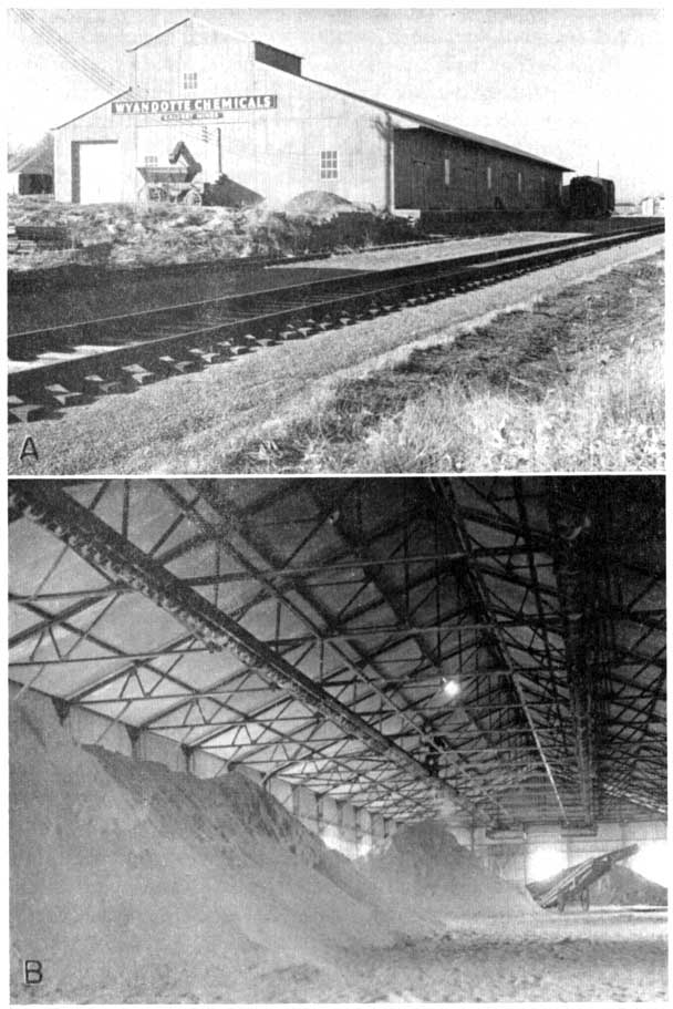
Active mining of volcanic ash was started in the vicinity of Calvert in 1908 and since that time one or more ash mines have been in almost continuous operation in this area. At the present time one large mine is operated at Calvert in the NW SW sec. 25, T. 2 S., R. 22 W. (NNV-1) by the Wyandotte Chemicals Corporation of Wyandotte, Michigan (Pls. 1A and 7). The ash is mined by the open-cut method, rough screened in the pit, and hauled by truck about one-eighth of a mile to a screening and storage plant along a rail siding at Calvert. In the section adjacent to the southwest, a large abandoned ash pit occurs in the NE NE sec. 35, T. 2 S., R. 22 W. Ash 17 feet thick has been exposed in the active pit faces in the Calvert area; it is reported that the maximum thickness of the bed determined by test borings is 22 feet. The pit of the Wyandotte Chemicals Corporation has been established as the type locality for the Calvert ash bed in the lower part of the Ash Hollow member of the Ogallala formation. The Calvert ash is a darker shade of gray than the Pearlette ash, and the ash exposed in the Calvert area is unaltered by weathering and is free of contaminants of silt and sand, although a few concretions of calcium carbonate occur disseminated throughout the deposit. About 2 feet of bentonite (Pl. 5B) and silty and clayey ash overlie the clean ash exposed in the pit. The deposit apparently extends into sections adjacent to the area of active mining and the quantity of ash available in the Calvert area is judged to be large.
Plate 7--Plant of Wyandotte Chemicals Corporation, Norton County. A, Storage and screening plant. B, Storage area (Swineford, 1951).
In addition to the Calvert area, volcanic ash has been mined at four localities in Norton County. In the SE SE sec. 25, T. 3 S., R. 25 W. (NNV-3), 10 feet of ash is exposed along the banks of a draw and in an abandoned pit. The owner reports that the maximum thickness of ash at the locality is 15 feet, and at the point where this deposit was sampled the overburden is only 4 feet thick. This deposit is petrographically similar to the Calvert ash; it is unaltered by weathering, and free of contaminants.
Ash 7 feet thick and underlain by silt is exposed in an abandoned pit in the SW SE sec. 2, T. 3 S., R. 25 W. (NNV-4) and also along both sides of a southeast-trending valley 280 yards northward from the section line road. This deposit, which is slightly altered by weathering and contains traces of sand and silt as contaminants, has been assigned petrographically to the Reager ash bed. Another small pit in the Reager ash bed occurs in the SW NW sec. 16, T. 2 S., R. 21 W. on the east side of a northward-trending valley southeast of the City of Almena. Volcanic ash 6.5 feet thick is exposed in the pit face, and the bed thins southward, with cementation of the upper part of the ash. On the east side of this same valley 2 to 3 feet of ash is exposed along the road cuts of the north-south section line road. A sample of the ash from this locality shows that it has been strongly altered by weathering and contains some calcite, but otherwise is relatively free of contaminants.
Four feet of volcanic ash is exposed in the face of a sand and gravel pit in the Cen. SE sec. 16, T. 1 S., R. 21 W. (NNV-8). The ash at this locality is assigned to the Reager bed. The deposit is relatively unaltered by weathering but contains a significant admixture of coarse sand and is underlain with sand. The extent of the ash is apparently small.
Volcanic ash is exposed at four additional localities in Norton County which have not been exploited. The thickest of these deposits was sampled at the Cen. S. line sec. 1, T. 3 S., R. 22 W. (NNV-6), where 9.5 feet of ash is exposed along the south side of a small valley of a northwestward-flowing stream. The exposure extends about 50 yards in an east-west direction. The overburden is about 15 feet thick and sand underlies the ash. This deposit is assigned only tentatively to the Reager bed for the ash has been somewhat altered by weathering.
A maximum of 5 feet of volcanic ash occurs along the west bank of a small creek in the SE SE sec. 27, T. 4 S., R. 23 W. (NNV-7) where it is exposed for about 100 feet and the overburden ranges in thickness from 5 to 20 feet; sand underlies the ash. This deposit, which can be seen on the west side of U.S. Highway 283, is tentatively assigned to the Calvert bed. The ash is significantly altered by weathering and the uppermost 2 feet contains a strong admixture of sand.
In the NW NW sec. 2, T. 4 S., R. 24 W. (NNV-2) a maximum of 4 feet of volcanic ash is exposed along the east side of a section-line road and in the nearby creek bank to the north. It has a small amount of silt and sand overburden and is underlain by calcareous silt and sand. This deposit is known to occur within the Ogallala formation but owing to alteration of the shards by weathering it has not been assigned definitely to any of the named beds.
Ash 2.5 to 3 feet thick is exposed along creek banks in the NE NW sec. 36, T. 2 S., R. 25 W. (NNV-5) and in the adjacent section to the north. Mortar beds 8 feet or more in thickness occur above the outcrop sampled and silt underlies the ash. This exposure has been established as the type locality of the Reager ash bed (Pl. 1B). The ash is slightly altered by weathering and contains a small quantity of sand.
Ottawa County
Two deposits of volcanic ash are known to occur in Ottawa County. At the largest of these a maximum of 6 feet of Pearlette volcanic ash is exposed along the east bank of a creek for about 100 feet in the NE NW sec. 29, T. 10 S., R. 5 W. (OV-l). The overburden at the locality sampled is about 14 feet thick. The ash is slightly weathered, nearly white in color, and relatively free of contaminants. Fossil snail shells occur abundantly in the clay at the base of the ash. A small deposit of volcanic ash in a bed about 2 feet thick occurs in the SE SW SE sec. 3, T. 9 S., R. 2 W. (OV-2) along a meander scar in a creek bank.
Phillips County
The largest of five deposits of volcanic ash known to occur in Phillips County and the only one that has been mined commercially to any extent is located in the SE NE (PHV-2) and the NE NE (PHV-3) sec. 33, T. 5 S., R. 19 W. In this area Pearlette volcanic ash is exposed in two pits. A maximum thickness of 15 feet of ash was found by auguring in the bottom of the pits. On the pit face where ash was sampled the overburden is only 2 feet thick. The ash is relatively unaltered by weathering and contains a trace of sand. In the SW SW sec. 14, T. 1 S., R. 18 W. a few inches of Pearlette ash crops out along the hillside a short distance north of the section-line road. This deposit is interesting petrographically because of the high degree of cementation by calcium carbonate (Pl. 4C).
Nine feet of Ogallala volcanic ash assigned to an unnamed bed occurs in the NE NE sec. 19, T. 2 S., R. 18 W. (PHV-1) and is also exposed in adjacent secs. 17 and 20. The lateral extent of the deposit is more than a quarter of a mile. A sample obtained by auguring through the bed 10 feet south of the pit showed the ash to be fresh and to contain a small amount of sand admixture. Six and a half feet of volcanic ash, petrographically similar to PHV-1, was sampled in the Cen. NE sec. 3, T. 2 S., R. 19 W. (PHV-4) on the east bank of a northward-flowing stream. The overburden above most of the deposit is excessive and includes 7 feet of mortar beds.
Reager volcanic ash is exposed along a road cut in the northern part of the NW NE sec. 30, T. 1 S., R. 19 W. (PHV-5). At the locality sampled the bed is about 1.5 feet thick but the upper half a foot contains calcium carbonate.
Pratt County
Four deposits of Pearlette volcanic ash were located and sampled in Pratt County. The thickest of these deposits was sampled from a pit in the S2 SW sec. 21, T. 27 S., R. 12 W. (PRV-1), where 14 feet of volcanic ash, the lower 10 feet fresh and free of contaminants, is exposed. The deposit is reported to extend into the adjacent quarter section to the east and southward across the section line into sec. 28; it is estimated to contain a reserve of 48,000 tons of ash. Throughout much of the area of this deposit the overburden is relatively thin.
Ten feet of volcanic ash overlain by 2.5 feet of mixed ash and sand was sampled in a pit in the NE SE sec. 22, T. 28 S., R. 14 W. (PRV-3). The ash is somewhat weathered and has about 2 percent sand and silt admixture. In the NW SE sec. 34, T. 27 S., R 12 W. (PRV-4), 4 feet of Pearlette volcanic ash was sampled in a pit where the ash is overlain by 6 feet of mixed ash, sand, and silt. The ash is altered somewhat by weathering which gives it a slightly higher clay content than is typical of Pearlette deposits. In the SW SW sec. 23, T. 27 S., R. 11 W. (PRV-2), 2.5 feet of Pearlette ash was sampled. This sample is slightly altered by weathering but is relatively free of contaminants. Volcanic ash is reported to underlie a 40-acre tract at the Cen. sec. 31, T. 27 S., R. 12 W. The owner reports that the ash deposit, which is not exposed, is 15 to 20 feet in thickness. The reserve of ash in the area is reported to be approximately 54,000 tons.
Rawlins County
In Rawlins County two deposits of volcanic ash, each having a maximum thickness of 14 feet, have been assigned to the Pearlette bed of Pleistocene age, one deposit has been assigned to the Reager bed of the Ogallala formation, and a fourth is not given definite stratigraphic placement. Of the Pearlette ash deposits, one occurs in the NE NW sec. 14, T. 3 S., R. 35 W. (RWV-1) and is underlain by clayey silt and sand where it has been mined. The upper 6 feet of the ash is exposed and the lower 8 feet was sampled by auguring. The second Pearlette deposit occurs in the NW SW sec. 22, T. 3 S., R. 35 W. (RWV-4), where a sample was taken from an intermittently active pit. The ash in both of these localities is exceptionally fresh and free of contaminants. Both of the deposits are probably extensive; however, the overburden ranges from 10 to more than 16 feet in thickness. The deposit in sec. 14 extends into the SW of the section where 10 feet of ash is exposed in a small gully.
The Reager volcanic ash bed is exposed in a steep bluff adjoining a section-line road and a valley in the W2 SW sec. 4, T. 4 S., R. 34 W. (RWV-2). The Reager ash bed, 2 feet thick and overlain by about 50 feet of overburden at this locality, is slightly altered by weathering and contains small calcite inclusions in the glass. Another exposure of Ogallala volcanic ash, not assigned to a stratigraphic position within the formation, occurs in the NW NW sec. 33, T. 3 S., R. 34 W. (RWV-3). Small outcrops along the edge of a valley indicate that this deposit extends 0.3 mile to the east and north and two auger holes penetrated 6 feet of ash. Sand and silt occurs below the ash. The material in RWV-3 contains 2 to 18 percent of calcium carbonate (Table 2).
Reno County
Several pits have been opened in a Pearlette volcanic ash deposit in the NE SW, NW SE (ROV-l), and SW NE sec. 14, T. 25 S., R. 8 W. Where this deposit was sampled 10 feet of ash is exposed in the face of a pit. The ash is relatively fresh and free of contaminants but one of the samples taken is somewhat coarse-textured. Although an estimate of tonnage has not been made, a large quantity of ash seems to be present in this area.
Three feet of volcanic ash is exposed in a small pit in the SE NE sec. 1, T. 25 S., R. 7 W. (ROV-2). The ash at this locality is calcareous, somewhat altered by weathering, but relatively free of sand contamination.
Rooks County
Landes (1928, p. 22) reports 15 feet of volcanic ash underlying an area of about 20 acres in the NE NE sec. 7, T. 8 S., R. 16 W. (RKV-2). At the time the area was visited for this investigation one auger hole bored through the deposit penetrated only 4.5 feet of ash. As this deposit is not exposed at the surface in this vicinity, it must be sampled by auguring or by a test pit. The one auger hole reported does not furnish basis for adequate evaluation of the deposit.
A maximum thickness of 10 feet of Pearlette volcanic ash is exposed in an inactive pit in the SW SW sec. 18, T. 7 S., R. 18 W. (RKV-l). The material is fresh and contains a trace of sand.
Six feet of volcanic ash is exposed for several hundred yards along the south and west bank of a meandering stream in the SW SE sec. 31, T. 9 S., R. 16 W. (RKV-3). An additional exposure of volcanic ash in the NW SE sec. 6, T. 10 S., R. 16 W. was reported by a local rancher.
Russell County
A large deposit of Pearlette volcanic ash occurs in the NW sec. 2, T. 15 S., R. 11 W. In this section 7 feet of ash is exposed in the NE NW (RV-2) and 10 feet is exposed in the SW NW (RV-3). These two exposures are nearly half a mile apart and it is quite probable that the deposit is continuous between them. The overburden in the vicinity of these two exposures consists of silt and silty ash ranging from 4 to 11 feet in thickness. The ash is fresh and relatively free of contaminants.
Landes (1928, p. 43) reports 5 feet of ash exposed for more than 350 feet in the upper part of gravel beds along the west side of a small valley near the southwest corner of sec. 19, T. 14 S., R. 13 W. This deposit was sampled for the present study in the SE cor. SW sec. 19 (RV-1) where 3 feet of ash is exposed for a lateral distance of 250 feet. The overburden consists of 4 feet or more of silt. Both of the Russell County deposits sampled are underlain by clay.
Seward County
During 1926 and for an unknown period thereafter a commercial volcanic ash pit was operated in the SW NE sec. 13, T. 33 S., R. 32 W. (SDV-3). Ash 8.5 feet thick is exposed in the face of the old pit where it is overlain by 5 feet of silt and brown sandy volcanic ash.
Pearlette volcanic ash which is fresh and free of impurities, although containing a few fossil shells in the lower part, is exposed in the NW NW sec. 35, T. 33 S., R. 32 W. (SDV-1). This deposit has a maximum observed thickness of 7 feet, but the thickness varies sharply throughout the exposure. The deposit occurs above sand and gravel beds with some silt and is overlain by silt and sand.
More than 8 feet of volcanic ash occurs below a very thin overburden in the SE SE sec. 35, T. 34 S., R. 31 W. (SDV-2). The upper 4 feet of this deposit is exposed in a shallow pit and 4 more feet of ash was penetrated by digging but the base of the deposit was not reached. This deposit occurs in a field along the south bluff of the Cimarron Valley.
Smith (1940, p. 201) lists two additional pits that have been operated in Seward County. These are a small pit along a road in the SE sec. 7, T. 31 S., R. 34 W. and a moderate-size pit, in operation at the time of Smith's report, in the NE sec. 19, T. 31 S., R. 34 W. Byrne and McLaughlin (1948, p. 25) report a large inactive volcanic ash pit in the SW sec. 19, T. 32 S., R. 33 W. They state that the volcanic ash exposed in this pit is 5 feet thick and relatively pure.
Sheridan County
Three deposits of Pearlette volcanic ash were sampled in Sheridan County. The largest of these deposits is exposed, along a road cut where 8 feet of minable ash is exposed in the face of a moderate-size inactive pit (Pl. 3B) in the NW NW sec. 34, T. 8 S., R. 28 W. (SNV-1). The ash, which is fresh and free of contaminants, is overlain by 2 feet of silty sandy ash and silt and sand.
Six feet of Pearlette volcanic ash is exposed in the east side of an old pit on the north side of a tributary valley in the NE SW sec. 11, T. 8 S., R. 28 W. (SNV-2). This deposit is also exposed about 200 yards to the southeast of the pit and across the main creek about 400 yards to the east. At the point where the deposit was sampled the overburden ranges from 5 to 10 feet and consists of silt and sandy silt. The ash is fresh and contains about 2 percent sand and silt.
Another small pit is located along an eroded terrace remnant on the north side of South Fork Solomon River Valley in the SE SW sec. 12, T. 8 S., R. 27 W. (SNV-3). Where the deposit was sampled it is 3.5 feet thick, is somewhat altered by weathering, and contains some calcite inclusions.
Smith County
In Smith County one large deposit of Pearlette volcanic ash occurs in the NW NW sec. 31, T. 3 S., R. 15 W. (SMV-1), where the ash crops out along the bank of an abandoned meander loop of a creek. The upper 8 feet of the deposit was sampled from the exposure and the bottom of the deposit was penetrated 7.5 feet below the base of the exposure by auguring. Landes (1928, p. 46) reports that the maximum thickness of this deposit is 22 feet. The ash is fresh and free of contaminants.
Three feet of volcanic ash is exposed along a hillside near the Cen. W. line sec. 32, T. 1 S., R. 14 W. and also across the north-south road in sec. 31 adjacent to the west. The ash is relatively fresh and contains a trace of sand. Local residents report that 4 feet of volcanic ash was penetrated by drilling in sec. 1, T. 3 S., R. 11 W. and that ash occurs in adjacent sec. 2. It is also reported that volcanic ash is exposed in sec. 36, T. 2 S., R. 11 W.
Stafford County
One deposit of volcanic ash is known to occur in Stafford County. Two feet of Pearlette volcanic ash was sampled by auguring in a sand dune depression in the NE SW sec. 28, T. 25 S., R. 11 W. The material is fresh and contains a trace of sand.
Trego County
Three deposits of Pearlette volcanic ash have been sampled in Trego County. Ten feet of volcanic ash is exposed in the face of a small pit located south of the Cen. sec. 36, T. 14 S., R. 21 W. (TV-3). The lower 6 feet of this deposit is free of impurities although slightly altered by weathering; however, the upper 4 feet is slightly contaminated. Volcanic ash 7.5 feet thick is exposed (Pl. 2C) along a steep creek bank immediately adjacent to the north bank of Smoky Hill River in the NW SE sec. 28, T. 14 S., R. 21 W. (TV-1). The deposit thins to the south and is overlain by about 5 feet of overburden. The ash is slightly weathered and free of impurities. Two feet of Pearlette volcanic ash which is fresh and contains a trace of sand is exposed in sec. 32, T. 14 S., R. 22 W. (TV-2).
Wallace County
Only one deposit of volcanic ash is known in Wallace County. This deposit is reported by Elias (1931, p. 211) and occurs in the SE SE sec. 8, T. 14 S., R. 38 W. (WCV-1). Here a maximum of 3 feet of ash resting on silt is exposed in the steep bluff under an overburden of 54 feet. The deposit was examined and sampled for this report and is assigned petrographically to the Reager bed within the Ogallala formation. The ash is relatively fresh and free of contaminants.
Washington County
One small deposit of Pearlette volcanic ash is known to occur in north-central Washington County. One foot of Pearlette ash is exposed along a road cut and creek bank in the NW cor. sec. 30, T. 1 S., R. 4 E. and on the west side of the section-line road in the NE cor. of the adjacent sec. 25, T. 1 S., R. 3 E. The ash in this deposit is somewhat altered by weathering but is free of contaminants. The extent of the deposit is probably small.
Prev Page--Uses || Next Page--References
Kansas Geological Survey, Kansas Volcanic Ash Resources
Comments to webadmin@kgs.ku.edu
Web version Jan. 2005. Original publication date Feb. 15, 1952.
URL=http://www.kgs.ku.edu/Publications/Bulletins/96/07_volcanic.html