Kansas Geological Survey, Bulletin 90, Part 4, originally published in 1951
Originally published in 1951 as Kansas Geological Survey Bulletin 90, Part 4.
Determination of some pertinent physical properties of 54 samples of crude oil from east-central Kansas are given. These samples were obtained both from fields now under primary production and from those now under secondary production.
For more than three quarters of a century oil has been produced from the relatively shallow sands of east-central Kansas. After production of oil by primary methods these fields have been abandoned in many cases. In some instances, however, productivity has been increased by repressuring with gas or air. In addition, water flooding has been applied to restore production long after a pool was abandoned for primary production. This method has also been used more recently to maintain the continuity of primary and secondary output. During recent years the trend has been steadily toward increasing quantity of oil produced by water flooding. The importance of water-flooding operations is evidenced by the fact that now more than 7,000,000 barrels of oil is produced annually in Kansas by this method. Most of the water flooding is being done in the eastern part of the State.
The rate of development for secondary recovery operations in the past has been influenced by numerous factors including the domestic and foreign situation as well as those within the oil industry itself. These factors could curtail completely the development of water flooding for a time, resulting in abandonment of production after the primary period.
With this possibility in mind, the State Geological Survey undertook to gather information concerning present active production which could be used to encourage further secondary recovery development. This information could also reveal whether or not some completely abandoned production can be flooded successfully. Also, in case some present production has to be abandoned, this information will be available when the situation becomes more favorable for secondary recovery development.
Secondary recovery operations have brought a new importance to certain types of technical data that formerly were not obtained at all, or else where considered to be of only minor importance to the problems of production. These facts, now needed in eastern Kansas oil production, include data on the physical properties of crude oil. Once a pool is abandoned it is often extremely difficult and expensive to determine the physical properties of the crude formerly produced; also data for many areas still active are not available. In order to obtain an adequate background of factual data on these old pools, which constitute future potential secondary recovery operations, the State Geological Survey has started the gathering of data on existing pools. This report gives the results of the first part of this study.
It is planned that future sampling and laboratory work will expand the scope of this information in conjunction with studies of subsurface stratigraphy and investigations of the character and petrography of the reservoir rocks. The ultimate goal is to assemble information which will make it possible at some time in the future to estimate more accurately in advance of flooding the response of various crudes to this production technique or to any other technique which might be developed.
General information on oil and gas developments in eastern Kansas has recently been published by the Survey (Jewett, 1949), and an annual review of petroleum developments is also published by the Geological Survey. The most recent of these (Ver Wiebe and others, 1950) summarizes developments during 1949 and Plate 1 of that report was the source of pool locations for Figure 1 of this report. The annual development reports published by the Geological Survey now contain a special summary of secondary recovery operations, particularly in eastern Kansas.
A gallon sample of each oil whose properties are reported in this paper was obtained at the lease and sealed immediately. The samples were then brought to Department of Petroleum Engineering laboratories at the University of Kansas where their physical properties were measured promptly.
The samples were gathered during the months of June, July, and August of 1950 from the east-central Kansas area. The locations of the wells from which samples were taken are shown in Figure 1 and are listed in Table 1. An attempt was made to obtain a fresh sample in each case. This was not possible in every instance, however; therefore some of the samples were taken from stock tanks. It is realized this could not give completely comparable results due to weathering, but the data obtained are sufficiently close to retain the correct relative positions among the samples. Most of the oils have little or no gas in solution when they are produced.
Figure 1--Map of southeastern and east-central Kansas showinbg oil pools. The first number of each location is the sample number in Table 1; the letter indicates profucing formation (B, "Bartlesville sand;" M, Mississippian limestone; P, "Peru sand;" S, "Squirrel sand"); the last number is A.P.I. gravity at 60° F.
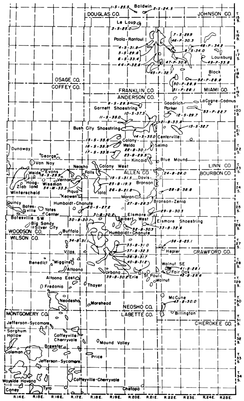
Table 1--Physical properties of samples of eastern Kansas crude oils.
| No. | Producing formation |
Location | A.P.I. gravity at 60° F |
Interfacial tension at 80° F |
Viscosity | |||
|---|---|---|---|---|---|---|---|---|
| Sec. | T., S. | R., E. | at 32° F | at 100° F | ||||
| 1 | "Squirrel" | 9 | 15 | 20 | 25.5 | 42.3 | 39.2 | |
| 2 | "Squirrel" | 11 | 15 | 20 | 24.5 | 43.9 | 44.9 | |
| 3 | "Squirrel" | 22 | 15 | 20 | 25.0 | 40.3 | 48.2 | |
| 4 | "Squirrel" | 32 | 16 | 21 | 31.8 | 32.9 | 51.2 | 9.2 |
| 5 | "Squirrel" | 36 | 16 | 21 | 29.6 | 22.4 | 106.2 | 12.9 |
| 6 | "Squirrel" | 36 | 16 | 21 | 33.4 | 38.1 | 28.5 | 6.7 |
| 7 | "Squirrel" | 10 | 17 | 22 | 29.9 | 33.9 | 47.7 | 13.5 |
| 8 | "Squirrel" | 15 | 17 | 21 | 34.0 | 33.7 | 27.5 | 7.3 |
| 9 | "Squirrel" | 2 | 20 | 20 | 29.5 | 33.2 | 65.5 | 11.9 |
| 10 | "Squirrel" | 33 | 20 | 21 | 37.3 | 32.8 | 12.6 | 3.9 |
| 11 | "Squirrel" | 35.0 | 26.3 | 21.8 | 5.3 | |||
| 12 | "Squirrel" | 30,29,20,19 | 20 | 22 | 29.7 | 35.2 | 89.6 | 12.0 |
| 13 | "Squirrel" | 14 | 21 | 22 | 32.7 | 21.7 | 40.4 | 7.9 |
| 14 | "Squirrel" | 16 | 21 | 20 | 35.0 | 29.1 | 20.1 | 5.1 |
| 15 | "Squirrel" | 34 | 21 | 19 | 35.6 | 27.1 | 17.2 | 4.7 |
| 16 | "Squirrel" | 2 | 22 | 19 | 35.9 | 32.0 | 15.9 | 4.4 |
| 17 | "Squirrel" | 28 | 22 | 19 | 33.6 | 26.0 | 31.2 | 6.3 |
| 18 | "Squirrel" | 24 | 23 | 16 | 25.9 | 37.9 | 320.6 | 38.3 |
| 19 | "Squirrel" | 27 | 23 | 18 | 31.5 | 34.1 | 54.7 | 10.2 |
| 20 | "Squirrel" | 28,27 | 25 | 17 | 27.2 | 35.2 | 169.2 | 24.7 |
| 21 | "Bartlesville" | 10 | 21 | 21 | 33.8 | 25.9 | 22.1 | 5.9 |
| 22 | "Bartlesville" | 9 | 22 | 21 | 30.1 | 30.9 | 64.4 | 11.7 |
| 23 | "Bartlesville" | 32 | 22 | 21 | 29.5 | 33.7 | 84.5 | 14.9 |
| 24 | "Bartlesville" | 22 | 23 | 21 | 26.0 | 41.5 | 264.2 | 31.7 |
| 25 | "Bartlesville" | 22 | 24 | 18 | 19.3 | 34.8 | 251.4 | |
| 26 | "Bartlesville" | 34 | 24 | 20 | 21.8 | 44.2 | 85.2 | |
| 27 | "Bartlesville" | 33 | 24 | 21 | 28.3 | 32.4 | 118.4 | 15.6 |
| 28 | "Bartlesville" | 26 | 24 | 21 | 38.8 | 22.9 | 44.2 | 9.0 |
| 29 | "Bartlesville" | 32 | 25 | 21 | 30.3 | 33.9 | 68.0 | 10.1 |
| 30 | "Bartlesville" | 16 | 26 | 18 | 30.1 | 35.6 | 55.0 | 10.4 |
| 31 | "Bartlesville" | 13 | 26 | 19 | 30.2 | 42.9 | 29.7 | 7.3 |
| 32 | "Bartlesville" | 19 | 26 | 20 | 30.3 | 42.9 | 27.8 | 12.8 |
| 33 | "Bartlesville" | 16 | 26 | 21 | 32.6 | 36.1 | 32.6 | 7.3 |
| 34 | "Bartlesville" | 27 | 27 | 18 | 31.1 | 36.7 | 42.3 | 8.4 |
| 35 | "Bartlesville" | 15 | 27 | 19 | 31.0 | 35.4 | 21.3 | |
| 36 | "Bartlesville" | 32 | 27 | 19 | 31.7 | 37.3 | 20.7 | 4.7 |
| 37 | "Bartlesville" | 33,34 | 27 | 19 | 32.3 | 34.1 | 32.6 | 7.1 |
| 38 | "Bartlesville" | 19 | 27 | 22 | 25.1 | 41.0 | 276.2 | 30.9 |
| 39 | "Bartlesville" | 26 | 28 | 19 | 30.2 | 32.2 | 74.6 | 11.6 |
| 40 | "Bartlesville" | 35 | 28 | 20 | 31.2 | 36.4 | 45.8 | 8.7 |
| 41 | "Bartlesville" | 28 | 28 | 22 | 28.1 | 33.4 | 120.6 | 16.7 |
| 42 | "Bartlesville" | 31 | 28 | 22 | 29.6 | 34.1 | 71.6 | 11.9 |
| 43 | "Bartlesville" | 19 | 30 | 22 | 30.0 | 36.5 | 13.8 | 11.1 |
| 44 | "Peru" | 15 | 17 | 21 | 32.8 | 33.1 | 28.6 | 7.3 |
| 45 | "Peru" | 26,35 | 17 | 21 | 32.7 | 20.1 | 27.1 | 7.6 |
| 46 | "Peru" | 10 | 17 | 22 | 30.3 | 37.3 | 42.6 | 11.0 |
| 47 | "Peru" | 22 | 17 | 22 | 30.6 | 36.2 | 47.1 | 10.1 |
| 48 | "Peru" | 4 | 17 | 23 | 34.2 | 32.0 | 19.0 | 5.8 |
| 49 | "Peru" | 19 | 17 | 24 | 33.8 | 28.8 | 15.3 | 6.0 |
| 50 | "Peru" | 26 | 18 | 22 | 28.9 | 32.0 | 95.8 | 16.9 |
| 51 | "Peru" | 27 | 18 | 22 | 28.1 | 32.2 | 143.2 | 11.2 |
| 52 | "Peru" | 29 | 18 | 23 | 28.8 | 31.4 | 106.2 | 26.3 |
| 53 | "Peru" | 10 | 20 | 23 | 22.7 | 32.5 | 98.0 | |
| 54 | Mississippian | 3 | 24 | 17 | 33.3 | 28.5 | 58.9 | 5.7 |
The A.P.I. gravity has been used to correlate other physical properties, as well as to indicate origin and similarity of crude oils; thus this property was measured for each crude oil sample. Also because the price of oil is based on the gravity, this property is generally available even for abandoned fields. Thus it could be used as a basis for estimating other physical properties when samples are not available.
Viscosity is a direct measurement of an oil's relative resistance to flow. In a given sand body, the higher the viscosity of the oil the greater the pressure drop required in order for the oil to move through the sand. Also, since the viscosities of the water in the various formations and that of injected waters are nearly identical there is a pronounced tendency for the injected water to by-pass the more highly viscous oil.
When two immiscible liquids such as water and oil are brought together, an interface forms at their point of contact. This interface contracts to occupy the smallest possible area. If the interface is formed in a capillary, the liquid which wets the capillary tends to spread a thin film over the capillary wall, increasing the interfacial surface area between the two liquids. However, the tendency for the interface to contract is still present so that the liquid which wets the capillary enters the tube, decreasing the interfacial area; this action produces a force that will displace the other fluid. As the capillary becomes finer this force increases; in a system of fine capillaries such as occur in many reservoir rocks, it becomes an important factor in displacing oil with water, which generally wets the rock. The tendency for the interface to contract is called the interfacial tension. The determination of this physical property is included in this study as a measure of the oil-water interface's role in flooding operations.
Gravity--The A.P.I. gravity for each oil was determined by means of hydrometers according to the American Petroleum Institute standard No. 526-39 (Am. Soc. for Testing Materials, 1949). The determinations were made at room temperatures and the national standard petroleum oil tables (U.S. Dept. Commerce, 1936) were used to reduce the observed values to 60° F. These tables were also used as a basis for determining the gravity at other desired temperatures similar to the temperatures at which the viscosities and interfacial tensions were determined.
Viscosity--The viscosity of each oil was determined at 32' F. and 100' F. using a modified Ostwald viscosimeter. The procedure used was the tentative method of test for kinematic viscosity (Am. Soc. for Testing Materials, 1949, Designation D445-46T, method B). The method is essentially a determination of the time required for approximately 3 cc of oil to flow through a capillary tube about 3 inches in length.
The viscosity was determined at only two different temperatures, as the American Petroleum Institute standard No. 533-43 (Am. Soc. for Testing Materials, 1949) provides a convenient means of finding the viscosity at any temperatures between the ones at which this property was measured. It should be noted that the viscosity also can be ascertained at temperatures slightly above and below these determined values.
Interfacial tension--The interfacial tensions were measured by means of the double cylinder apparatus described by Bartell (1938, p. 69). The method consists principally of placing the oil and water in a vessel, then determining the height to which water rises above the oil-water level in a capillary tube located vertically between the liquids. The measurements were made at 80° F. since this temperature could be maintained conveniently.
Data table--The test data for 54 samples of crude oil from east-central Kansas are given in Table 1. General conclusions concerning the physical properties of eastern Kansas crude oils and the effect of these properties on flooding operations cannot be made until a more complete inventory has been done. The, present report serves primarily to place these data now available in usable form for owners, operators, and companies in eastern Kansas.
American Society for Testing Materials(1949) A.S.T.M. Standards on petroleum products and lubricants: Am. Soc. for Testing Materials, Philadelphia, Pa., pp. 1-1420.
Bartell, F. E. (1938) Laboratory manual of colloid and surface chemistry: Edwards Bros., Ann Arbor, Mich., pp. 1-187, figs. 1-42.
Jewett, J. M. (1949) Oil and gas in eastern Kansas: Kansas Geol. Survey, Bull. 77, pp. 1-308, figs. 1-53, pls. 1-4.
U. S. Department of Commerce (1936) National standard petroleum oil tables: Natl. Bur. Standards, Circ. C410, pp. 1-175, figs. 1-2.
Ver Wiebe, W. A., and others (1950) Oil and gas developments in Kansas during 1949: Kansas Geol. Survey, Bull. 87, pp. 1-176, figs. 1-31, pls. 1-3.
Kansas Geological Survey, Energy Resources
Placed on web July 25, 2008; originally published in May 1951.
Comments to webadmin@kgs.ku.edu
The URL for this page is http://www.kgs.ku.edu/Publications/Bulletins/90_4/index.html