![]()
Prev Page--Stratigraphy || Next Page--Economic Geology, Summary
Study of the Tonganoxie Sandstone
Previous Work
Early workers (Bennett, 1896; Hall, 1896; Haworth, 1896), in their sections across Kansas, described the basal sandstone of the Lawrence shale as resting upon strata now classified as beds of the Pedee group. Hinds and Greene (1915) described the basal sandstone as a wide channel fill, unconformably overlying various formations now classed as parts of the Lansing and Pedee groups. A study of the physical characteristics of the sandstone by Moore (1931) indicated a flood-plain type of deposit. Patterson (1933) compiled much information on the lithology and stratigraphic relations of the sandstone, known then as the Stranger sandstone and as the basal member of the Stranger formation. The sandstone was named Tonganoxie sandstone in 1934 (Moore, Elias, and Newell). Moore (1936) summarized all information available in 1936 and described lithology, stratigraphic relations, the pre-Tonganoxie erosion surface, and a possible origin and environment of deposition of the Tonganoxie sandstone. Bowsher and Jewett (1943) published results of studies on coal beds of the Stranger formation and described many characteristics of the Tonganoxie sandstone.
General Statement
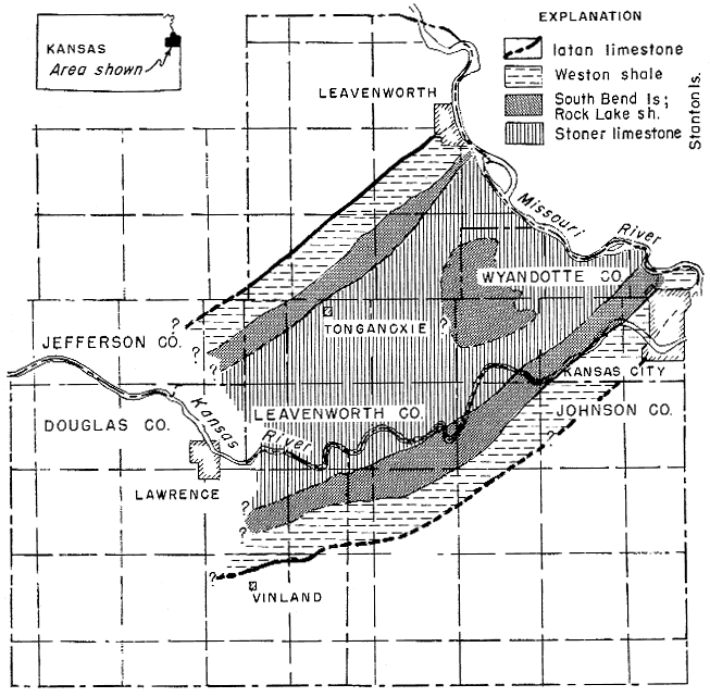
The Tonganoxie sandstone represents the filling of a large southwest-trending valley, here termed the Tonganoxie Valley, a major feature of the regional disconformity which separates the Pedee group or older beds (Missourian) from the overlying Douglas group (Virgilian). A generalized paleogeologic map of the floor and sides of this Pennsylvanian valley is shown in Figure 1, and a cross section of the valley is given in Figure 3. Both of these illustrations indicate the presence of late Missourian strata extending along the floor and sides of the valley. This is determined from observations of the rocks which occur next below the Tonganoxie sandstone in various places. The pattern shown by the strata was formed by the cutting of the Tonganoxie Valley into the relatively flat-lying Stanton limestone and formations of the Pedee group. The valley floor in various places is directly underlain by the Stoner limestone, Rock Lake shale, or South Bend limestone (the three upper members of the Stanton limestone). The sides of the valley are formed by the Weston shale and the divides are held up by the Iatan limestone (formations of the Pedee group). Unreliable subsurface data prevented tracing of the valley beyond the Tonganoxie sandstone outcrop area.
Figure 1--Generalized geologic map of the disconformity at the base of the Tonganoxie sandstone.
Present outcrops closely parallel the old Tonganoxie Valley (Pl. 1), because the north-northeast regional strike nearly coincides with the trend of the valley and because post-Pennsylvanian erosion has stripped away Virgilian (and possibly Permian and Cretaceous) deposits which covered this region before development of the present land surface. In the past, knowledge of the stratigraphy and sedimentation of the Tonganoxie sandstone has been retarded by the failure to recognize that the present outcrop is approximately parallel to the old Tonganoxie Valley and is not at right angles to the direction of the source of sediment.
The depth of erosion of the Tonganoxie Valley can be ascertained in two ways; by compiling thicknesses of eroded formations from measured sections in near-by areas, and by measuring the maximum thickness of the Tonganoxie valley fill (Tonganoxie sandstone).
The thickness of stratigraphic units which were removed during erosion of the Tonganoxie Valley are: Stoner limestone, 4 feet; Rock Lake shale, 8 feet; South Bend limestone, 10 feet; Weston shale, 60 feet; and Iatan limestone, 2 feet. Only in a few places has erosion cut to the top of the Captain Creek limestone. These are average thicknesses which add up to 84 feet; 90 feet is an approximate figure for the maximum depth of valley erosion.
No complete sections of the Tonganoxie sandstone are exposed and the thickness, therefore, is determined from composite sections. Thicknesses of 85 feet for the sandstone unit and 20 feet for the shale unit indicate 85 feet of valley fill. Due to numerous variations in the thickness of the conglomerate and the coal units and variations in the depth of valley erosion, a maximum thickness of 80 to 100 feet of valley fill is a better estimate. On divides adjacent to the valley, the Upper Sibley coal is found 3 to 10 feet above the Iatan limestone. This indicates that the Tonganoxie sandstone filled the entire valley and overlapped the divides slightly. The figures of 80 to 100 feet of maximum valley fill and 80 to 95 feet of maximum valley erosion are comparable.
Lithology of the Tonganoxie Sandstone
The Tonganoxie sandstone contains four distinct lithologic units, which (in ascending order) include conglomerate, sandstone, shale, and coal.
Conglomerate Unit
The constituents of the conglomerate unit are: (1) pebbles of limestone, siltstone, and claystone; (2) reworked invertebrate fossils; (3) plant fragments; (4) quartz sand and silt; and (5) limonite, clay calcite, and siderite cement.
Spaces around the pebbles are filled in by quartz sand and silt, plant material, and shale. A few shale and sandstone partings occur locally. Limonite, clay, calcite, and traces of siderite cement the conglomerate into a hard mass.
The limestone, siltstone, and claystone pebbles range in diameter from 5 to 50 mm, 20 mm being average. The limestone and siltstone pebbles are well rounded and the claystone pebbles are compressed. They are poorly sorted and show no clearly marked orientation denoting currents which distributed them. Limestone pebbles are light brown, gray, blue gray, dense, and fine-grained. On weathered surfaces, iron oxides give a reddish color to the pebbles. The siltstone pebbles, although well rounded, are slightly elongated. This is due in part to derivation from thin-bedded siltstone layers and in part to a small amount of compaction. The siltstone pebbles show various shades of brown and red, due to staining by limonite and hematite.
The siltstone pebbles, together with the compressed claystone pebbles, are identical in color and lithology to the associated siltstone and shale of the Tonganoxie sandstone. Their origin can be attributed to reworking of beds of the Tonganoxie member, as discussed later.
Abundant plant fossils occur throughout the conglomerate, seemingly at random, either as carbonized material, molds, or imprints. Some plant fragments are 4 feet long and have compressed diameters of 5 inches.
The conglomerate unit occurs widely at the base of the Tonganoxie sandstone, where it rests on various members of the Stanton limestone and locally on the Weston shale. The thickest, best-developed conglomerate occurs in the northeastern part of the Tonganoxie Valley. A good outcrop can be seen along U.S. Highway 73, 0.5 mile north of Victory Junction, in southern Leavenworth County. In many small areas, the conglomerate is missing, as might be expected in a valley-fill type of deposit. Where the conglomerate is absent, the sandstone unit of the Tonganoxie member rests directly on Missourian rocks.
Sandstone Unit
Texture--The sandstone unit comprises almost three-quarters of the sediment of the Tonganoxie member. Colors generally range from light to dark brown. Iron oxide occurs throughout as a stain and as cementing material, imparting a variety of colors to the sandstone. Mechanical analyses of two representative samples are given in Table 2. The sand is composed largely of quartz grains ranging in size from one-sixteenth to one-fourth mm. Grains more than one-fourth mm in diameter are scarce and consist mostly of mica flakes. From 10 to 40 percent of the sandstone consists of quartz silt. The proportions of silt, very fine sand, and fine sand vary both laterally and vertically. Muscovite is present throughout. Results of sieve analyses, shown in Table 2, bear out the field observation that as the proportion of larger size sand grains increases, the amount of muscovite decreases; and, conversely, as the proportion of larger size sand grains decreases, the amount of muscovite increases. Although not shown in Table 2, the muscovite flakes having largest diameter occur among the coarser sands. This relationship of amount and size of mica flakes to coarseness of the sand reflects the competency of currents which transported the material, and is therefore a significant feature of the sandstone. A considerable amount of muscovite is present on the bedding planes of the siltstones and imparts a lamellar appearance; carbonaceous material produces the same effect in other siltstone beds.
Table 2--Representative analyses of the Tonganoxie sandstone.
| Size | Percent sand by weight |
Percent mica by volume |
|---|---|---|
| Festooned cross-bedded sandstone | ||
| 0.50 - 0.25 mm | Trace large flakes | |
| 0.25 - 0.125 mm | 44.40 | 1.0 |
| 0.125 - 0.0625 mm | 42.20 | 0.3 |
| Below 0.0625 mm | 13.40 | Trace |
| Very fine silty sandstone (thin-bedded) | ||
| 0.50 -0.25 mm | 0.87 | 90.0 |
| 0.25 -0.125 mm | 33.00 | 25.0 |
| 0.125 - 0.0625 mm | 22.60 | 20.0 |
| Below 0.0625 mm | 43.53 | 20.0 |
Composition--Quartz constitutes more than 95 percent of the sand grains, which are angular to subangular. Binocular examination and petrographic study of thin sections reveal that on many grains angularity has been accentuated by secondary quartz growth. Many such grains, exhibiting small crystal faces, have uniform extinction under crossed nicols.
Muscovite, clay, limonite, and a few grains of tourmaline comprise most of the remaining 5 percent of the detrital material. Small amounts of chlorite occur, which probably represent minor amounts of original biotite (Lee and Payne, 1944, p. 90). Muscovite in sufficient quantity to form 25 percent of the detrital material occurs in some beds. Argillaceous layers and the valley shale remnants within the sandstone unit are composed largely of clay minerals. Light-brown interstitial clay is universally present, and serves as a weak cement. Limonite occurs in small grains and as cementing material. Tourmaline is rare; grains of this mineral were found only after large quantities of Tonganoxie sediment had been separated in bromoform. Plant material and ironstone concretions occur in zones indiscriminantly distributed through the sandstone unit. Where the basal conglomerate is absent and the sandstone unit rests on limestones of the Stanton formation, the sandstone is cemented by calcite and is gray rather than brown.
Stratification--Deposition of the sandstone unit produced three types of stratification: (1) festooned cross-bedded siltstone and sandstone; (2) massive-bedded siltstone and sandstone; and (3) thin-bedded argillaceous siltstone, sandstone, and silty shale. The composition of these types is essentially identical, except for the greater amount of fine material in the thin-bedded type.
Festooned cross-bedding was first described by Knight (1929) in the Fountain and Casper formations of Wyoming. It consists of numerous cut and fill structures, each cut being an elongate trough which is closed at the upstream end and open at the downstream end. The fill consists of oblique crescentic laminae which occupy the trough from. its head to downstream end, thus forming a narrow elongate cross-laminated lens. In the Casper formation and also in the Tonganoxie sandstone, such cross-bedded lenses occur in nested groups, each lens truncating the subjacent and adjacent lenses, and in turn truncated by the superjacent lenses. The overall appearance is that of a nested group of cut and fill structures. The Tonganoxie beds exhibiting festooned stratification rest on eroded members of the Stanton limestone. The festooned cross-bedding of the Tonganoxie sandstone is not as well developed and is on a smaller scale than that described by Knight. The oblique laminae are shorter, and presumably owing to weaker current action during Tonganoxie sedimentation, large cut and fill structures, which Knight interpreted as marine cross-bedding, did not develop.
The trough-shaped channels containing the oblique laminae are as much as 20 feet long and are 6 to 8 feet wide. The laminae, which are 0.5 to 3 inches thick, have dip angles of as much as 30 degrees. Generally these laminae are 2 to 6 feet in length. All oblique laminae are concave upward, truncated at the top, and tangent to the base of the lens which they form. Many of the oblique laminae of sandstone and siltstone alternate with thin micaceous and carbonaceous silty to shaly laminae.
Directions of dip of the cross-bedded oblique laminae range from north through west to south. Since cross beds produced by river currents generally dip downstream, the most common direction of dip indicates the down-valley trend. This most common dip direction of the Tonganoxie oblique laminae is west-southwest to southwest. Therefore, the axis of the Tonganoxie Valley is judged to have extended in this direction.
The massive-bedded type of stratification consists of siltstones and sandstones which contain excellent examples of the sedimentary phases described by Gilbert (1914). These are (1) thin beds of the first phase of smooth traction, (2) cross beds of the first dune-rippled phase, and (3) thin beds representing a return to first phase smooth traction.
The massive-bedded stratification grades downward and laterally into festooned stratification and upward and laterally into the thin-bedded type. An excellent example of massive bedding can be seen along a creek in Douglas County, just north of the Cen. E. line sec. 26, T. 13 S., R. 21 E.
The thin-bedded type of stratification is best developed along margins of the Tonganoxie Valley. Throughout the area, this type occurs at the top of the sandstone unit and grades into the overlying shale unit. This stratification is characterized by thinness of the beds and their high content of mica and carbonaceous material,
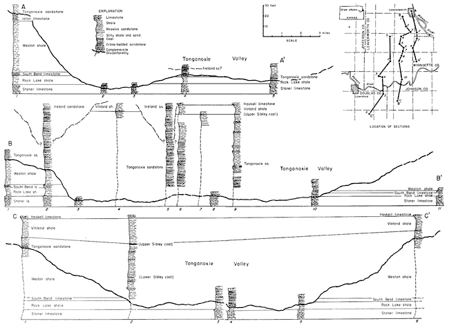
Abnormally thick sections of shale, to 60 feet thick, occur locally in the Tonganoxie member. (Fig. 3, sec. C-C', column 2). The lower part of these shales grades laterally into the sandstone unit of the Tonganoxie, but the upper part of the shales belongs to the shale unit. Since the lower shales are stratigraphic equivalents of the sandstone unit and seem to have been deposited contemporaneously with the sands of the sandstone unit, they are here termed "valley shales." These valley shales occur as isolated remnants in the Tonganoxie Valley.
The valley shales are even-bedded, blue gray to dark blue, and contain zones of ironstone concretions. Interbedded with the shales are numerous thin siltstone and sandstone beds with well-developed ripple marks. Some thin coals ( Lower Sibley) are contained in the valley shale.
The sandstone unit of the Tonganoxie thins from 65 feet in the main channel area to 5 feet along the margin of the Tonganoxie Valley. As shown in Figure 2, the festooned cross-bedded and massive-bedded siltstones and sandstones occur in the lower and central parts of the valley where the sandstone unit is thickest and grade laterally and upward into the thin-bedded sandstone type which characterizes the margins of the valley (Fig. 3, sec. C-C').
Figure 2--Diagrammatic cross section showing relation of Tonganoxie sandstone to Tonganoxie Valley.
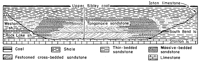
Figure 3--Diagrammatic cross section showing relation of Tonganoxie sandstone to Tonganoxie Valley. A larger version of this figure is available.
Shale Unit
The shale unit of the Tonganoxie grades upward from and overlies sediments of the thin-bedded type throughout the Tonganoxie Valley. It consists of two distinct phases, silty shale and clay shale. The silty shale is highly micaceous and ranges in color from light brown to dark red or brown. Fine carbonaceous material and fossilized plant fragments are abundant throughout. No marine fossils have been observed.
The clay shale is light bluish gray to dark blue and contains minor amounts of mica. The shale is sticky to firm, and in many zones fracture surfaces exhibit slickensides. The shale is even-bedded, individual layers reaching an inch in thickness. Bands of hollow and solid ironstone concretions are common. Plant fragments are especially abundant in shale beneath the thin coal beds and in equivalent intervals where accumulation of plant material was insufficient to form a coal bed.
The shale unit is commonly silty where it overlies the festooned cross-bedded sandstone of the valley and where the lower part of the overlying Vinland shale is sandy. The thickness of the shale unit ranges from 10 to 25 feet.
Coal Unit
The Upper Sibley coal is designated as the coal unit of the Tonganoxie member. This coal bed is the uppermost stratum of the Tonganoxie and can be correlated throughout the Tonganoxie Valley. The Upper Sibley coal maintains a fairly constant stratigraphic position across the valley from north of Leavenworth to Vinland, in Douglas County (Pl. 1). Identification of the lateral continuity is strengthened by the presence of the overlying dark-blue limestone, which is correlated with the Westphalia limestone.
The Upper Sibley coal varies in thickness. At some places the coal is represented by a thin shale containing plant fossils. Elsewhere, the coal is a fairly pure bed which increases in thickness to an observed maximum of 20 inches near the town of Tonganoxie. The average thickness is about 8 inches. Stems, leaves, and trunks are preserved either as molds or as carbonized material; limbs and trunks exhibit leaf scars and limb attachment marks. The plant molds are found at the basal contact of the coal. Upper and lower parts of the coal have shale partings but the central part is generally a well-developed coal, free from clay. No underclay has been observed and roots or trunks were not observed in place. Ironstone and rare calcareous and pyrite concretions occur widely under the coal zone. The percolation of ground water through the coal has somewhat altered the subjacent shale.
The upper part of the Upper Sibley coal grades through 3 to 4 inches of calcareous carbonaceous shale into a carbonaceous argillaceous laminated limestone which has been correlated with the Westphalia limestone of southern Kansas (Moore, 1949). In northern Leavenworth County, abundant small high-spired gastropods occur in the gradational beds and in the lower part of the Westphalia limestone. Excellent impressions of tree trunks, limbs, and leaves are preserved throughout the limestone. Where the Upper Sibley coal is not identifiable or is absent, the base of the Westphalia limestone can be used as the upper stratigraphic boundary of the Tonganoxie sandstone.
Other bituminous coal beds occur below the Upper Sibley in the shale and sandstone units of the Tonganoxie sandstone. In general, these beds are thin and laterally not extensive. Except for the Lower Sibley coal, correlation from area to area is difficult.
The Lower Sibley coal is contained in valley shales which are lateral equivalents of the sandstone unit. Since these valley shales are isolated remnants surrounded by sandstones of the sandstone unit, correlation of the Lower Sibley coal is based on stratigraphic position. Valley shales containing the Lower Sibley coal are exposed on the Sumner farm in the NW cor. sec. 24, T. 11 S., R. 21 E. and at Blue Mound (Douglas County) on the S. line sec. 21, T. 13 S., R. 20 E.
Within the sandstone unit, the thin coal beds are preserved mostly in local lenticular remnants of valley shale, but such occurrences are not common. A thin local bed occurs north of Bonner Springs at the Cen. S. line sec. 17, T. 11 S., R. 23 E. The stratigraphic relationship is shown on Figure 3 (column 5, sec. A-A').
Relations of the Tonganoxie Sandstone to Overlying Beds
Normally in northeastern Kansas, the Upper Sibley coal is stratigraphically overlain by the Westphalia limestone, Vinland shale, Haskell limestone, and Ireland sandstone. However, the Ireland sandstone in most localities rests disconformably on the Haskell limestone and older strata. Locally throughout the area, erosion which is recorded by the disconformity reached the sandstone unit of the Tonganoxie member; subsequent deposition of the Ireland resulted in a very thick section of sandstone. Therefore, an understanding of the relation of the Ireland and Tonganoxie sandstones is important to study of geology in the area.
Haworth (1894, p. 122), in naming the Lawrence shale, miscorrelated the limestone now called Haskell with the Iatan limestone. Hall (1896), Haworth (1896), and Hinds and Greene (1915) recognized only one sandstone body in the section. Hall and Haworth recognized the shallow-water characteristics of the basal sandstone member of this sequence but did not observe the large stratigraphic erosional surface on which the sandstone was deposited. Later detailed stratigraphic work by members of the State Geological Survey of Kansas revealed upper and lower sandstone bodies, resting unconformably on older formations and in places one on the other. The upper sandstone (above the Haskell limestone) was named Ireland (Moore, 1932) and was classified as the basal member of the Lawrence shale. The lower sandstone (below the Haskell limestone and above the true Iatan), locally in contact with various members of the Stanton limestone, was named Tonganoxie sandstone (Moore, Elias and Newell, 1934) and was regarded as the basal member of the Stranger formation.
The Ireland sandstone rests disconformably upon the Stranger formation in most localities. Lithologically, the Ireland sandstone is indistinguishable from the basal member of the Stranger formation, the Tonganoxie sandstone. The Ireland generally is more reddish, owing to its higher iron oxide content, but this distinction cannot be used over wide areas. In places, the pre-Ireland erosion and the deposition of the Ireland sandstone directly on the sandstone unit of the Tonganoxie resulted in thick sections of sandstone which have been mapped previously as Tonganoxie sandstone. Examples are in the vicinity of Hodge, Leavenworth County. Combined sections of Ireland and Tonganoxie sandstone 100 to 150 feet thick occur locally throughout the area. A few of these thick sandstone sections contain a conglomerate of siltstone and mud balls cemented by clay and calcium carbonate. The conglomerate probably marks the contact between the two sandstone bodies. An excellent example of such a conglomerate is seen in an outcrop west of the railroad track along the N. line sec. 36, T. 10 S., R. 22 E. Well-defined Ireland sandstone is found to the west of this outcrop, the Haskell limestone is absent, and the obviously greater abundance of disseminated iron in the sandstone above the conglomerate indicates that the conglomerate probably marks the contact between the Ireland and Tonganoxie sandstones.
Laterally, the lower part of the Ireland sandstone may be found at the same stratigraphic level as shales of the Tonganoxie sandstone member and seems to grade into them. Failure to recognize the upper sandstone as Ireland and the shales as Tonganoxie has retarded understanding of the origin and environment of both the Tonganoxie and Ireland sandstones.
Field work has shown that in practically all sections where the Haskell limestone is present, the Upper Sibley coal occurs 7 to 18 feet below its base. Where sandstone occupies this interval the Haskell limestone is absent. Absence of the Haskell limestone and the Upper Sibley coal in near-by areas and the presence of sandstone at the same stratigraphic horizon definitely identify the sandstone as Ireland. This points to deep post-Haskell erosion prior to deposition of Ireland sandstone.
Sedimentary Origin and Environment of the Tonganoxie Sandstone
General Statement
As shown in Figures 1 and 3, the Tonganoxie sandstone occupies a southwest-trending valley, 14 to 20 miles wide and 80 to 100 feet deep. The prevalent southwesterly dip of laminae in the festooned cross-bedded sandstone indicates that the Tonganoxie River flowed from northeast to southwest.
Disconformity
The regional disconformity at the base of the Virgilian Series, of which the disconformity at the base of the Tonganoxie sandstone is a part, denotes a time of widespread retreat of the Pennsylvanian sea in the midcontinent region. Post-Missourian folding in the southwestern part of the midcontinent suggests that the regional disconformity was not due entirely to a eustatic change of sea level. With retreat of the sea, erosion cut the Tonganoxie Valley and produced the disconformity which coincides with the floor of the valley.
Reconnaissance work north and south of the Tonganoxie Valley has revealed no similar erosional valley. In these areas, the disconformity seemingly occurs in the midst of a shale sequence which overlies the Iatan limestone and underlies or is part of the Vinland shale. In localities where the Iatan limestone is absent, the disconformity is between the Weston shale and the overlying Vinland shale.
While erosion, unaccompanied by local sedimentation, proceeded north and south of the Tonganoxie Valley, erosion and concurrent deposition took place in the valley. As thickness of sediment in the Tonganoxie Valley increased and as the sea encroached, erosion of the valley ceased, but north and south of the valley it continued. Accordingly, the part of the disconformity which is marked by the base of the Tonganoxie sandstone is not precisely equivalent in time value to the disconformity elsewhere. Also, the sediment which ultimately came to be deposited over the divide areas north and south of the valley was laid down after the Tonganoxie Valley had been filled. This indicates that in regional correlation, the Tonganoxie sandstone is a little older than sediments overlying the disconformity in areas outside the valley.
Tonganoxie Valley
The Tonganoxie Valley is interpreted as having been cut by a basinward-flowing river which, owing to retreat of the sea, was forced to cross an emerged sea bottom. Faunal and sedimental evidence indicates that the Pennsylvanian seas were shallow. Consequently, the initial dip of the sediments (dip of the profile of equilibrium) was very gentle and small vertical changes in sea level uncovered or submerged large areas. The gradients of rivers flowing over such emerged sea bottoms evidently were low, but sufficient to permit excavation of shallow valleys.
The ratio of 14 to 20 miles of valley width to 80 to 100 feet of valley depth indicates that the Tonganoxie River was near grade and that minor fluctuations in current velocity could result in either erosion or deposition.
Erosion and Deposition in the Tonganoxie Valley
Initial deposition of the Tonganoxie sandstone is judged to have been contemporaneous with erosion in the Tonganoxie Valley. (1) The Tonganoxie Valley is very shallow compared to its width, indicating that the river must have been close to grade and that valley erosion was primarily lateral rather than downward. It is probable that a river carving such a shallow wide valley would be depositing at one place and eroding at another, all at the same time. (2) The basal conglomerate seems to be of local origin (as discussed below). (3) Festooned cross-bedded sandstone occurs in the areas of deepest erosion and inferred strongest currents, and thin-bedded sandstones occur where erosion was least. (4) Valley shale deposits seemingly were contemporaneous with the sandstone unit.
Present large streams, which are near or at grade, are continually reworking their flood-plain and channel deposits. During times of floods, valley widening and deepening take place in the channel and deposition occurs on the flood plain. As the channel shifts, sediment is removed from parts of the flood plain and redeposited elsewhere. Such valley sedimentation is contemporaneous with valley erosion and does not represent deposition subsequent to carving of the entire valley.
Sources of Sediment
The immediate sources of Tonganoxie sediments may be sought in sandy and silty near-shore and alluvial facies of earlier Pennsylvanian sediments to the east and north of the area, or in pre-Pennsylvanian terranes such as occur in the Ozark dome, Wisconsin Highlands, or the Appalachian region.
The sandstones and siltstones of the Tonganoxie are composed largely of angular quartz grains. Other detrital minerals are scarce, except muscovite. No rounded frosted sand grains of the St. Peter type have been observed. It seems probable that the Tonganoxie siltstones and sandstones represent reworked micaceous sediments of Pennsylvanian age which were exposed by the retreat of the sea and were transported westward from the upstream parts of the Tonganoxie River system.
Most of the limestone pebbles are lithologically similar to the Stanton and Iatan limestones. This suggests that the pebbles were derived from these formations, probably at places not far distant from the deposits of conglomerate. The poor sorting of the pebbles and the intermixture of pebbles with water-worn brachiopods, crinoid fragments, and some fusulinids also indicate that the pebbles were of a local detritial origin.
Deposition of the conglomerate unit--The cutting of the Tonganoxie Valley indicates that during erosive periods the river acquired a load from its channel to supplement the sand, silt, and clay transported from farther east. The Tonganoxie Valley area of northwestern Missouri and northeastern Kansas was underlain by limestones and shales of the Missourian Series. Little sand or silt was available for river load. Consequently, the traction load of the river was augmented by fragments of locally derived limestone and shale. These fragments were seemingly too large for the usual competency of the river; they were shifted from place to place as the valley formed and were concentrated as the basal conglomerate of the Tonganoxie sandstone.
Deposition of the sandstone unit--The sediment of the Tonganoxie sandstone shows that the Tonganoxie River was transporting fine micaceous sand, silt, and clay which were deposited in the channel and on the flood plain of the Tonganoxie Valley. The main channel area of the Tonganoxie Valley is shown by the location of extensive deposits of festooned cross-bedded and massive-bedded siltstones and sandstones.
To my knowledge, festooned cross-bedding has not been observed in modern sediments or produced in the laboratory. It has not been reported widely from the older sediments. Presumably, it results from alternate cutting and filling of troughlike channels by strong shifting currents.
Clay accumulated in the local lakes and swamps of the flood plain while silt and sand were deposited in the channel areas. The clay material became valley shales. The ripple-marked siltstone and sandstone beds within the valley shales may represent times of minor flooding when current action was strong. Some plant material accumulated in the valley shale material, as is shown by the presence of the Lower Sibley coal. Later channel migration failed to remove the valley shale deposits and they remain as remnants of formerly more extensive deposits surrounded by the festooned cross-bedded and massive-bedded siltstones and sandstones of the sandstone unit.
Deposition of the shale unit--The gradual change in lithology from the thin-bedded strata of the sandstone unit into the overlying shale unit represents a change in depositional environment. This change seems to reflect reduction of the river gradient and slow encroachment of the sea from the west. Beds tentatively identified as brackish water in origin, overlain by marine strata, occur widely above the Tonganoxie sandstone. This sequence of strata is interpreted to represent progress toward marine conditions and establishment of marine conditions in the area. The initiation of the marine invasion was probably contemporaneous with deposition of the shale and coal units and partly may have been responsible for the reduction of river gradient.
The association and lithology of the shale unit suggest that deposition took place in broad shallow lakes, swamps, and on the partly inundated flood plain of the Tonganoxie Valley. The blue-gray to dark-blue color of the iron-bearing shales indicates that the water table was high and that the environment was primarily one of reduction, rather than oxidation. The high content of carbonaceous material in the shales also suggests that reducing conditions prevented complete oxidation of the organic matter. Iron was precipitated in the swamps and lakes, probably as iron carbonate, forming ironstone concretions. Where colloidal clay was present, clay ironstone beds formed.
No invertebrate fossils have been found in the shale unit. Although the environment seems to denote reducing conditions, there is no evidence of pyrite, marcasite, black shales, and other signs of "foul bottom" conditions. If the shale unit had been deposited in a marine environment, occurrence of marine invertebrates should furnish proof.
Deposition of uppermost beds of the shale unit terminated existence of the Tonganoxie Valley. The shale material filled the valley and overlapped the divides (Fig. 3, sec. C-C'). Deposition of the shale unit was followed by accumulation of the material of the Upper Sibley coal over what had been the Tonganoxie Valley and in small areas north and south of the divides.
Deposition of the coal unit--Characteristics of the Upper Sibley coal and associated sediments have been studied in order to determine the origin and environment of deposition of the coal. The following are significant features of the Upper Sibley coal.
1. The coal zone can be recognized within the Tonganoxie Valley and on the marginal divide areas, but in many places the coal is absent and a carbonaceous shale represents the zone.
2. Sections of the coal bed show no clay or silt in the middle part.
3. Plant material, consisting of stems, limbs, trunks, and leaves, was the parent material of the coal.
4. Plant remains are well preserved in subjacent and superjacent strata and show no signs of having been transported by currents.
5. Subjacent shales are well bedded but plant material is not parallel to the bedding planes.
6. Subjacent shales are nonmarine.
7. Underclay has not been observed.
8. Fossils, tentatively identified as fresh to brackish-water forms, occur in overlying beds, but no definitely marine fossils have been found.
9. Subjacent and superjacent strata grade into coal.
Bowsher and Jewett (1943, p. 38) suggest that coals of the Stranger formation possibly may have been produced from detrital plant material which accumulated in a marine littoral environment. Coals of such allochthonous origin would have to have been brought into' place by currents. Moore (1940) states that at least 15 to 20 feet of vegetable matter is required to furnish material for 8 to 12 inches of coal. If this is true, the average 8-inch thickness of the Upper Sibley coal represents approximately 15 feet of vegetable material. It seems to me that fluctuations in currents during the time required for deposition of the 15 feet of vegetable material at least occasionally would have brought in silts and clays. The lack of interbedded silt or clay in the Upper Sibley coal suggests that the coal is not detrital. The coal does grade upward and downward into plant-bearing clay shale but the central part is free from clay.
The leaves, stems, limbs, and trunks preserved in the Lower and Upper Sibley coals, and in the subjacent and superjacent gradational shales, show no signs of having been transported from their place of growth. Fragile leaves and stems are preserved intact. Bark with leaf and limb attachment scars is preserved on the trunks. There is no abrasion or other evidence indicating their transportation as detritus.
Physical similarities of the Upper Sibley coal to the Lower Sibley coal also indicate a.common origin. On the basis of its stratigraphic relations, the Lower Sibley coal seems definitely to be nonmarine. The Lower Sibley coal is preserved in valley shale remnants which grade laterally into definitely nonmarine beds of the sandstone unit, and is overlain by the nonmarine shale unit of the Tonganoxie sandstone.
I am of the opinion that the Lower and Upper Sibley coals are of continental autochthonous origin. There is a possibility that some of the very thin local beds in the sandstone and shale units may have been derived from previously formed peat or coal beds which were reworked and redeposited, but physical charactristics of the coal beds give the impression that original peat and plant material which later formed the coal accumulated in situ.
Considering the Tonganoxie sandstone as a depositional unit, the Upper Sibley coal seems an integral nonmarine member of a depositional sequence or cycle. The sequence of nonmarine sandstone, followed by nonmarine shale, and finally by coal, indicates a reduction of current action in the area and the final filling of the Tonganoxie Valley by organic deposits. Marine sediment of the overlying Vinland shale represents completion of marine flooding and beginning of the marine part of a cyclothem.
Tonganoxie Sandstone and Cyclic Deposition
The conditions of deposition of the Tonganoxie sandstone may explain the absence of the nonmarine sand, shale, and coal units of certain cyclothems in the Pennsylvanian sections in Kansas.
Upper Pennsylvanian cyclic deposition in Kansas primarily expresses sea level fluctuations. Marine and nonmarine deposition closely followed the shifting shore lines. During most of late Pennsylvanian time in northeastern Kansas, the shore line was farther east. Erosion has removed the eastern, dominantly nonmarine, facies of most of the Pennsylvanian cyclothems. These missing facies contained the nonmarine units of cyclothems which are represented by marine beds in Kansas. Deposition of the Tonganoxie sandstone marked a time when the eastern nonmarine facies extended well into Kansas. Successive stratigraphic sections to the west should reveal that the Tonganoxie sandstone grades into marine sediments. Where the equivalent of the Tonganoxie sandstone is marine, a stratigraphic section would lack the nonmarine sand, shale, and coal units of a cyclothem.
Stratigraphic sections which include sediments of the Tonganoxie Valley and its overlying deposits contain the nonmarine sandstone, shale, coal, and marine units of a cyclothem. Stratigraphic sections outside the valley contain only the marine units of this cyclothem, although uppermost parts of the nonmarine unit may be present. Sections of the latter type may lead one to believe that the nonmarine units should be found only farther east, whereas actually, the nonmarine units are restricted to a near-by valley.
Prev Page--Stratigraphy || Next Page--Economic Geology, Summary
Kansas Geological Survey, Geology
Placed on web Aug. 7, 2006; originally published Oct. 31, 1950.
Comments to webadmin@kgs.ku.edu
The URL for this page is http://www.kgs.ku.edu/Publications/Bulletins/86_5/04_lith.html