![]()
Prev Page--Geography || Next Page--Ground Water
Geology in Relation to Ground Water
This report is chiefly concerned with the geology and the occurrence of ground water in the alluvium in the Kansas and Missouri River Valleys. Brief consideration is given, however, to the underlying bedrock which is in the Pennsylvanian System and to the glacial drift and loess of Pleistocene age.
Pennsylvanian System
The bedrock underlying the Kansas City area belongs to the Kansas City, and Lansing groups of the Missourian Series of the rock classification called the Pennsylvanian System (Jewett and Newell, 1935, pp. 159-185; Moore, 1940, pp. 43-48).
The Missourian Series has a total thickness of about 600 feet and is characterized especially by numerous limestone beds separated by clayey to somewhat sandy shale. Broadly speaking, these rocks are not good aquifers, but they supply much of the ground water for farm wells on the upland in Wyandotte County. During years of low precipitation many of these farm wells either go dry or yield inadequate supplies of water for domestic and stock needs. Limestones that are water-bearing near the outcrops include especially. the Stanton, Plattsburg, Wyandotte, Iola, and Dennis limestones.
Quaternary System
The consolidated rocks of this area are to a large extent overlain by much younger unconsolidated materials. These deposits consist of glacial drift and loess of Pleistocene age and alluvium of Pleistocene and Recent age.
Pleistocene Series
During Pleistocene time the northern part of the United States was invaded by several successive ice sheets or glaciers, some of which reached to and in some places beyond the Missouri and Kansas River Valleys. According to Darton (1915, p. 5):
In the earlier part of the glacial epoch, called the Kansan stage, the ice sheet extended from the north halfway across northeastern Kansas, reaching the present valley of Kansas River and in places extending a few miles south of it. Probably the ice sheet had much to do with determining the position of the Kansas River Valley, for the river began at that time to flow in its present general course. This ice sheet covered about 4,000,000 square miles in northern North America about 300,000 years ago and endured for a long time. It was several thousand feet thick, and it accumulated at a time when the fall of snow was in excess of melting and evaporation. Its southern edge was in the zone where melting kept pace with the advance of the ice, and apparently in some stages of its existence its margin remained at the same place for a long time. Its flow was due mainly to the thickness of the ice, for the land does not at all slope downward to the south, which was the direction of the movement.
As the glacier moved along it picked up large quantities of rock and soil. This material was slowly carried southward and in some areas accumulated at the southern edge of the ice in a deposit known as a terminal moraine. When melting gained on the rate of advance the glacial front receded and the clay, sand, gravel, and boulders which the ice had contained were left behind in a sheet covering the rocks of the country. This deposit is called till or drift.
According to Jewett and Newell (1935, p. 185):
The oldest deposits of Pleistocene age recognized in Wyandotte County are isolated remnants of till of Kansan age occurring in places on the hilltops. These deposits are rare and consist of a heterogeneous association of erratics, worn boulders of local limestone, and sand. The foreign boulders and pebbles consist mainly of Sioux quartzite, with numerous granites and metamorphic rocks.
These glacial deposits are located above the water table in Wyandotte County and, consequently, are of little importance as a source of ground water.
Pleistocene and Recent Series
Loess--Younger deposits of probable Pleistocene age include the widespread loess, a yellowish to brownish fine-grained silt found bordering the valleys. The loess covering is thickest along the edge of the bluff of Missouri River, where in some places it attains a thickness of more than 50 feet. Farther from the edges of the valley it is much thinner and gradually becomes indistinguishable from the soil covering. The loess is absent along the north side of Kansas River between Edwardsville and Bonner Springs, probably having been removed by erosion inasmuch as it is continuous along the south wall of the valley. South of Bonner Springs loess covers the indurated formations as far west as Loring. The eastern part of Wyandotte County is covered by an irregular layer of loess, effectively hiding the underlying formations in the vicinity of Kansas City.
Some farms in Wyandotte County obtain meager ground-water supplies from wells in loess. The loess is very porous, but its fine texture makes it relatively impervious. Where water-bearing, it yields a low flow into wells, and although these wells may afford a steady source of supply, none of them yield large quantities of water.
Alluvium--Alluvium of Recent age and probably some of Pleistocene age occurs in the Kansas and Missouri River Valleys and some of their larger tributaries. The alluvium consists of stream-laid deposits that range in texture from clay and silt to sand and very coarse gravel. The character of the alluvium varies greatly depending on its origin and mode of deposition. Much of the alluvium in the Kansas Valley near Kansas City probably is of glacial origin, having been deposited as glacial outwash by the swollen streams that emanated from the melting ice sheets. Test holes were drilled along five lines across the Kansas Valley and along one line across the Missouri Valley to determine the thickness and character of the alluvium in the two valleys. Another line of test holes was drilled across part of the Missouri Valley. The cross sections and locations of the cross sections are shown in Plate 1, and the logs of the test holes are given at the end of this report. As shown by the cross sections, the thickness of the alluvium in the Kansas Valley ranges from about 51 to 77 feet. The width of the Kansas Valley at the cross sections ranges from 1.0 to 1.6 miles. The alluvium in the Missouri Valley averages 95 feet in thickness and the valley at that cross section is 2.1 miles wide. The thickness of the alluvium and the width of the valley at each cross section are given in Table 1.
Table 1--Thickness of the alluvium and width of valley for five cross sections in the Kansas River Valley and one cross section in the Missouri River Valley
| Valley | Cross section |
Number of test holes |
Width (miles) |
Average thickness (feet) |
|---|---|---|---|---|
| Missouri | A-A' | 11 | 2.1 | 95 |
| Kansas | C-C' | 7 | 1.4 | 77 |
| Kansas | D-D' | 5 | 1.2 | 76 |
| Kansas | E-E' | 8 | 1.6 | 71 |
| Kansas | F-F' | 7 | 1.0 | 61 |
| Kansas | G-G' | 10 | 1.2 | 51 |
The logs and cross sections (Pl. 1) indicate that the material above the water table is not as permeable as that at greater depth. Several feet of the surficial material is composed largely of silt and clay but most of it is slightly sandy. The surficial material is underlain by gravel and sand interbedded with lenses of silt and clay.
The altitudes and shape of the surface of the bedrock beneath the alluvium in the Kansas and Missouri River Valleys in the Kansas City area are shown in Figure 4 by contour lines, based on the records of the test holes drilled by the State Geological Survey, records of test holes supplied by the Corps of Engineers, U. S. Army, and reported depths to bedrock in many industrial wells. In general, the valleys have wide and relatively flat bedrock floors. The bedrock rises abruptly from the channels beneath the valley ami crops out at an altitude of approximately 760 feet along the marginal areas.
Figure 4--Contours on the bedrock in the Kansas and Missouri River Valleys in the Kansas City, Kansas, area.
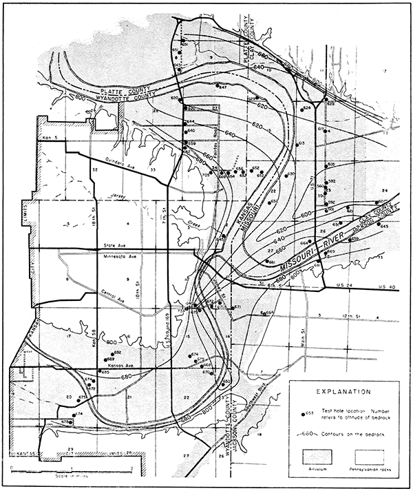
Test holes drilled by the Corps of Engineers revealed the presence of a deep and narrow channel extending northeastward from the mouth of the Kansas River. It will be noted in cross section C-C' (Pl. 1) that there is a deep narrow channel near the western edge of the valley, and that in cross section D-D' (Pl. 1) the bedrock is low at test hole 101. No evidence is available, however, to indicate that the channel extends farther up the Kansas River Valley. There is a possibility that this channel extends up Turkey Creek Valley and that it was formed during Pleistocene time. According to McCourt and others (1917, pp. 81-82):
During the Tertiary epoch there are indications that the drainage was to the east. . . . Turkey Creek then flowed across the site of Kansas City, joining the Big Blue near its mouth. . . . When the ice front pushed south, it came to the large river that occupied the present Kansas and lower Missouri Valleys. The ice front was probably lobed and it seems that two of these lobes pushed across the river, one into the northern part of Kansas City and one into the region near Sibley, at first damming back the streams and then forcing them across low points on the divides. The Kansas was in this way forced into the former valley of Turkey Creek. . . . With the melting of the Kansan glacier, . . . the new streams thus formed received large quantities of water from the melting of later ice sheets in the northern states. Turkey Creek took advantage of the new opening into the Kansas and abandoned its pre-glacial valley.
Prev Page--Geography || Next Page--Ground Water
Kansas Geological Survey, Geohydrology
Placed on web Oct. 4, 2016; originally published February 1948.
Comments to webadmin@kgs.ku.edu
The URL for this page is http://www.kgs.ku.edu/Publications/Bulletins/71/04_geol.html