Kansas Geological Survey, Bulletin 165, pt. 1, originally published in 1963
Originally published in 1921 as Kansas Geological Survey Bulletin 6, pt. 6. This is, in general, the original text as published. The information has not been updated. An Acrobat PDF version (10 MB) is also available.
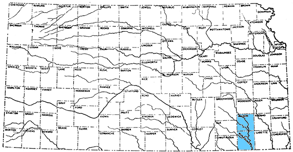
Wilson and Montgomery counties are situated in southeastern Kansas, approximately fifty miles from the Missouri state line to the east, and bordering the Oklahoma state boundary on the south. Together they form a rectangle twenty-four miles in width from east to west and fifty-one miles in length from north to south, an area of approximately 1,200 square miles. (See location map, figure 1.) The areal and structural geology of these two counties is much the same, and for this reason they may conveniently be considered as a unit in this report.
Figure 1--Location map of Wilson and Montgomery counties.
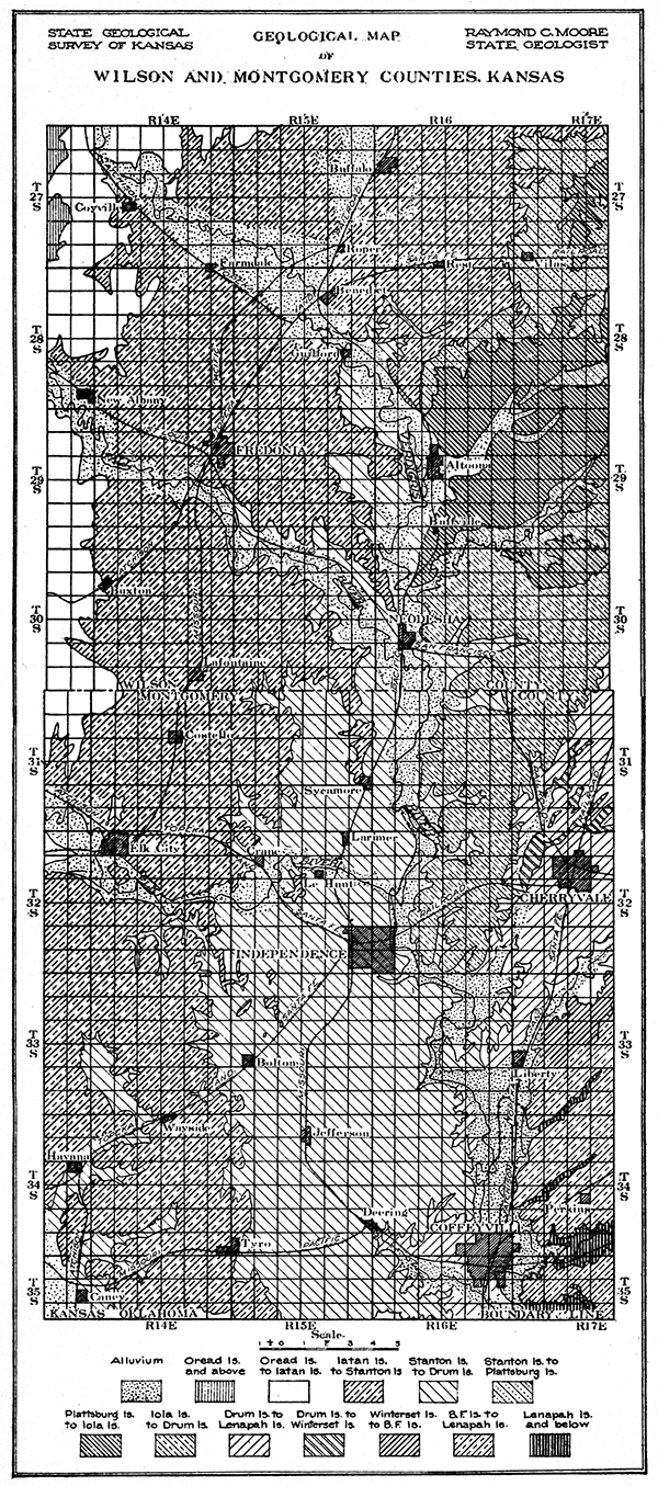
Wilson and Montgomery counties are a typical portion of the plains country of eastern Kansas and Oklahoma. The chief topographic features are escarpments formed by resistant beds of limestone and sandstone, the positions of which are for the most part shown on the geological map (plate I). These escarpments are most prominent where massive hard beds overlie a considerable thickness of shale, as in the base of the Stanton-Plattsburg escarpment. In some cases they are more than 200 feet high. The steep slopes are, broadly speaking, to the east, while west of the escarpments are more or less extended, nearly level areas which reach to the base of succeeding escarpments. The nearly level country, five to eight miles in width, west of Verdigris river, about Independence and to the south, lies between the escarpments of the Drum and Stanton limestones. Locally, as between Elk City and Bolton, where erosion has cut back deeply and irregularly into an escarpment, the topography is very rough. In a number of places outliers of limestone and sandstone form prominent knobs or hills, commonly known in this region as mounds. Examples are Walker mound and Table mound near Independence and Twin mounds south of Fredonia. The sandstone hills, which are in the southwest part of the area, north of Caney and Havana, are covered by a dense growth of scrub oak. Geological work in the sandstone country is much more difficult than in other parts of the region.
Plate I--Geological map of Wilson and Montgomery counties.
The elevation of the region ranges from high points in western Wilson County, which exceed 1,100 feet above sea level, to 690 feet in the Verdigris river valley south of Coffeyville, which is the lowest elevation in Kansas. The average elevation of the two counties is about 875 feet.
The drainage in Wilson and Montgomery counties is toward the south and southeast. The largest stream, Verdigris river, enters Wilson County near the northwestern corner and flows in an irregular course southward to the southeast corner of Montgomery County. Neodesha, Independence and Coffeyville are located in its valley. Other important streams are Fall river, which joins the Verdigris from the west at Neodesha, and Elk river, which flows eastward across north central Montgomery County into the Verdigris near Independence. Small tributary streams east of the Verdigris river flow southwest.
The area included in Wilson and Montgomery counties is a rich farming country. For this reason, and largely as the result of extensive oil and gas development, the population is large and there are within the area an unusual number of prosperous towns and cities. The most important cities are Independence, Cherryvale and Coffeyville, in Montgomery County, and Fredonia, Neodesha and Altoona, in Wilson County. Numerous industrial activities center in this region.
Intersecting lines of four railroad systems-the Atchison, Topeka & Santa Fe, the Missouri Pacific, the St. Louis & San Francisco, and the Missouri, Kansas & Texas-provide a close network of railway transportation which serves excellently all parts of the area. An electric interurban connects Coffeyville, Independence and Cherryvale, and extends eastward to Parsons in Labette County. Good automobile and wagon roads make readily accessible almost all parts of the region.
Since Wilson and Montgomery counties were among the first in Kansas to produce oil and gas in large quantities, they have received attention in a number of reports of the United States Geological Survey and the Kansas Geological Survey. These reports have been freely used in this publication, and reference is given wherever possible. The Survey is indebted to the Empire Gas and Fuel Company for the use of their outcrop maps and vertical sections in this area.
About 1860 a number of shallow wells which yielded oil and traces of natural gas were drilled in southeastern Kansas. In 1881 small quantities of gas were found at a number of places near Independence. A company formed there for the purpose of mining coal drilled a well in 1884 and found gas at 1,200 feet. The gas became ignited, did much damage, and was abandoned without any attempt to use it. In 1889 gas was found in moderate quantities near Cherryvale, and about a year later at Coffeyville, the gas being piped to Independence and Cherryvale in 1893. [Schrader, F. C., and Haworth, E., loco cit. pp. 20-22.] At first the supply was small, but from 1902 to 1904 a number of wells were drilled which had an initial open-flow capacity ranging from 12,000,000 to 37,000,000 cubic feet of gas daily.
Montgomery County became an oil-producing district in 1903, with the opening of the Bolton pool, which in 1904 had over 200 producing oil wells. A few of these wells had an initial production of 1,000 barrels a day, and 150- to 200-barrel wells were quite common. At present there is no sharp division between the various oil and gas fields of Montgomery County, and the early fields near Independence, Bolton, Wayside and Havana might now properly be classed as one large producing district.
Prospecting for oil and gas began in the vicinity of Neodesha in 1890, and the results were sufficiently attractive to interest the. Pittsburg firm of Guffey & Galey. They secured a number of good oil wells near Neodesha, but prospected at many other points in eastern Kansas with but little success. [Haworth, E., Kansas University Geol. Sur., Special report on oil and gas, vol. 9, pp. 29-41, 1908.] Recent developments show that many of the dry holes drilled by this firm were practically on the edge of productive oil pools. In 1895 Guffey & Galey sold their Kansas holdings to the Forest Oil Company, which was later reorganized, and is to-day known as the Prairie Oil and Gas Company. Gas was first lighted in Neodesha, July 4, 1894. The towns of Fredonia, Benedict and Buffalo became oil and gas centers about 1900.
The rocks exposed at the surface in Wilson and Montgomery counties belong to the middle portion of the Pennsylvanian system. They consist of alternating beds of shale, limestone and sandstone, the shale amounting to approximately 70 per cent of the total thickness. The limestones, and locally the sandstones, form more or less prominent escarpments, those best defined occurring in the west portion of the area. The shales are commonly not well exposed on account of the readiness with which they weather. They form the nearly level or gently rolling topography between the escarpments. The dip of the strata in this region is to the west, so that in crossing either county from east to west one passes from older to younger formations.
The geologic divisions which outcrop in Wilson and Montgomery counties are the Marmaton, Kansas City, Lansing and Douglas formations. The relation of these divisions to other parts of the Pennsylvanian in Kansas, and the members of which they are composed, are shown in the following table. The divisions are arranged in the order in which they appear geologically, the lower formations below, and the upper above.
| Table showing the geological divisions of Wilson and Montgomery counties, and their relation to other rock formations of Kansas. | ||||
| Quaternary | ||||
| Recent | ||||
| Alluvium (includes deposits along streams in Wilson and Montgomery counties) | ||||
| Pleistocene | ||||
| Glacial deposits (northeastern Kansas) | ||||
| Tertiary (western Kansas) | ||||
| Cretaceous (western and north central Kansas) | ||||
| Comanchean (south central Kansas) | ||||
| Permian (central Kansas) | ||||
| Pennsylvanian (eastern Kansas) | ||||
| Missouri group | ||||
| Wabaunsee formation | ||||
| Shawnee formation | ||||
| Douglas formation | Exposed in Wilson and Montgomery counties |
|||
| Oread limestone | ||||
| Lawrence shale | ||||
| Iatan limestone | ||||
| Weston shale | ||||
| Lansing formation | ||||
| Stanton limestones | ||||
| Vilas shale | ||||
| Plattsburg limestone | ||||
| Lane shale | ||||
| Kansas City formation | ||||
| Iola limestone | ||||
| Chanute shale | ||||
| Drum limestone | ||||
| Cherryvale shale | ||||
| Winterset limestone | ||||
| Galesburg shale | ||||
| Bethany Falls limestone | ||||
| Ladore shale | ||||
| Hertha limestone | ||||
| Marmaton formation | ||||
| La Cygne shale | ||||
| Lenapah limestone | ||||
| Nowata shale | ||||
| Altamont limestone | ||||
| Bandera shale | ||||
| Pawnee limestone | ||||
| Labette shale | ||||
| Fort Scott limestone | ||||
| Cherokee shale | ||||
| Mississippian (southeast Kansas) | ||||
| Devonian and Silurian (?) | Not exposed in Kansas |
|||
| Ordovician | ||||
| Cambrian | ||||
| Pre-Cambrian | ||||
The Marmaton formation outcrops in the southeast corner of Montgomery County, the exposures being limited chiefly to the valleys of Pumpkin, Big Hill and other tributaries of the Verdigris east of Coffeyville. Only the uppermost portion of the formation appears in Montgomery County. The Kansas City formation, which lies next above the Marmaton, may be traced from north to south across the central and eastern portions of Montgomery County and southeastern Wilson County. The large content of limestone in the Kansas City formation, which characterizes exposures farther north, is not so evident here. Neither the Hertha limestone at its base nor the Iola limestone at its top have been traced across Montgomery County. One of the important members of the formation, the Drum limestone, which is named from Drum creek, in Montgomery County, has a thickness of eighty feet locally in this area, but is very irregular in thickness. Its outcrop is shown in plate I. The Lansing formation is prominent in west central Montgomery County and across the central portion of Wilson County. The Stanton limestone at its top makes one of the most striking escarpments in the area. It extends northward from Tyro across Elk river halfway between Independence and Elk City, thence in an irregular line northeastward into Wilson County toward Neodesha. It extends up Fall river to Fredonia and on either side of Verdigris river between Altoona and Benedict, and is mapped northeastward past Vilas to the corner of the county. Almost all of western Montgomery County and northwestern Wilson County are occupied by strata belonging to the Douglas formation. The thin Iatan limestone member has been identified in western Wilson County and the Oread limestone appears at the extreme northwest corner of the county.
The following measurements reported by geologists of the Empire Fuel and Gas Company show the thickness of the geologic divisions in various parts of Wilson and Montgomery counties.
| Stratigraphic sections in Wilson and Montgomery counties. | |||
| T. 27-28 S., R. 15 E. | Feet | ||
|---|---|---|---|
| Lansing formation: | |||
| Stanton limestone: | |||
| Upper ledge | 15-20 | ||
| Shale | 15 | ||
| Lower ledge | 20-25 | ||
| Vilas shale | 87 | ||
| Plattsburg limestone | 17 | ||
| Lane shale | 48 | ||
| T. 28 S., R. 14 E. | Feet | ||
| Douglas formation: | |||
| Oread limestone: | |||
| Lawrence shale | 210 | ||
| Iatan limestone: | |||
| Upper ledge | 3-5 | ||
| Shale | 8 | ||
| Lower ledge | 5 | ||
| Weston shale | |||
| T. 31 S., R. 15 E. | Feet | ||
| Lansing formation: | |||
| Stanton limestone | 45 | ||
| Vilas shale | 10-15 | ||
| Plattsburg limestone | 80 | ||
| Lane shale | 105 | ||
| Kansas City formation: | |||
| Iola limestone | 2-4 | ||
| T. 27 S., R. 16 E. | Feet | ||
| Weston shale | |||
| Lansing formation: | |||
| Stanton limestone | 37 | ||
| Vilas shale | 85 | ||
| Plattsburg limestone | 17 | ||
| Lane shale | 48 | ||
| T. 29 S., R. 15 E. | Feet | ||
| Lansing formation: | |||
| Stanton limestone | 60- 70 | ||
| Vilas shale | 10- 25 | ||
| Plattsburg limestone | 20-80 | ||
| Lane shale | |||
| T. 81-88 S., R. 17 E. | Feet | ||
| Kansas City formation: | |||
| Iola limestone | 3-6 | ||
| Chanute shale | 55 | ||
| Drum limestone | |||
| Upper ledge | 3-6 | ||
| Shale | 24 | ||
| Lower ledge | 10-12 | ||
| Cherryvale shale | 70-90 | ||
| Winterset limestone | 6-11 | ||
Southward from the Wilson-Montgomery County area into Oklahoma the geological formations undergo changes which have made difficult the identification of corresponding stratigraphic units, especially since the field work in Kansas and Oklahoma has been done almost entirely by different groups of geologists. In view of the continuity of the oil and gas fields across the state boundary it is very desirable to determine the equivalents in Oklahoma of the stratigraphic units identified in Kansas. The following table shows as closely as possible the correlation of the Kansas divisions with those employed by the Oklahoma Geological Survey in the area adjacent to Montgomery County.
| Table showing tentative correlation of stratigraphic divisions in Wilson and Montgomery counties, Kansas, with those in northeastern Oklahoma. | ||||
| Kansas | Oklahoma | |||
|---|---|---|---|---|
| Divisions | Thickness, feet |
Divisions | Thickness, feet |
|
| Douglas formation: | ||||
| Oread limestone | 20-60 | Oread limestone | 0-17 | |
| Lawrence shale | 200-300 | Shale | 170 | |
| Iatan limestone | 5-15 | Labadie limestone | 15-20 | |
| Weston shale | 60-100 | Shale | 100-150 | |
| Lansing formation: | ||||
| Stanton limestone | 20-40 | Avant limestone | 0-20 | |
| Vilas shale | 50-125 | |||
| Plattsburg limestone | 6-80 | |||
| Lane shale | 50-150 | Shale and sandstone | 125-200 | |
| Kansas City formation: | ||||
| Iola limestone | 2-40 | Dewey limestone | 23 | |
| Chanute shale | 25-100 | Shale and sandstone | 75 | |
| Drum limestone | 0-80 | Hogshooter limestone | 10 | |
| Cherryvale shale | 25-125 | Shale and sandstone | 300-400 | |
| Winterset limestone | 5-40 | ? Lost City limestone | 1-40 | |
| Galesburg shale | 5-60 | Shale | 170 | |
| Bethany Falls limestone | 0-22 | ? Checkerboard limestone | 2-10 | |
| Ladore shale | 0-40 | Shale and sandstone | 200 | |
| Hertha limestone | 10-20 | |||
| Marmaton formation: | ||||
| La Cygne shale | 100-150 | |||
| Dawson coal | 3 | |||
| Lenapah limestone | 2-10 | Lenapah limestone | 20 | |
| Nowata shale | 70 | Nowata shale | 70 | |
The normal dip of the strata in Wilson and Montgomery counties is slightly north of west at the rate of twenty to twenty-five feet per mile, but in many places this has been interrupted by more or less pronounced folds. The structure of the Independence Quadrangle is shown on plate II by means of twenty-foot contours which represent the elevation of the Stanton limestone above sea level. This map was constructed from the topographic and geologic maps prepared by Schrader and Haworth in Bulletin 296 of the United States Geological Survey. The Stanton limestone is found only in the western half of the quadrangle, so it was necessary to use a number of varying intervals in determining the elevation of the Stanton limestone in the eastern half of the county. The resulting map is by no means accurate in detail, and is used in this report to show as nearly as possible from data available the generalized structure of the area.
Plate II--Structure map of Independence Quadrangle
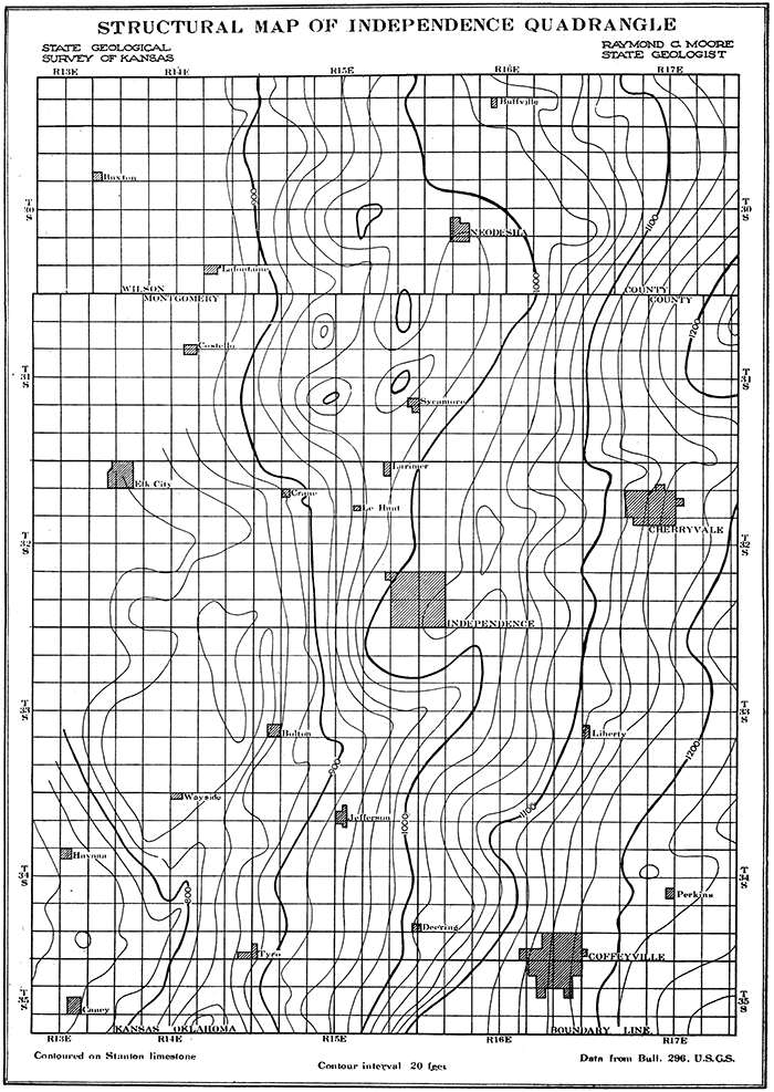
It may be noted (plate II) that there is a well-defined fold in the vicinity of Cherryvale, and a somewhat smaller fold east of Coffeyville. Directly west of Coffeyville the beds are almost flat, and between the Coffeyville and Cherryvale anticlines there is another small fold, southwest of Liberty. Between this fold and Independence there is a rather pronounced syncline pitching toward the southwest. In the vicinity of Neodesha the strata are almost flat, although interrupted here and there by a number of small domes.
One of the most important considerations in the development of any oil territory is the relation between the apparent surface structure and the producing oil and gas horizons. In Wilson and Montgomery counties these reservoirs consist of lenticular bodies of sandstone interbedded with shale. These sandstones are irregular and local in character, varying greatly in their horizontal and vertical extent. They do not form continuous and definite horizons, but pinch out laterally or grade into shale. Under such conditions surface structure and production could not be expected to have that fixed relation found in regions underlain by definite and continuous oil and gas sands.
The Cherryvale oil and gas district is situated on a broad anticline. Elk City gas field lies near the crest of two small domes. [Boughton, Charles W., The Elk City gas field, Kansas Geo!. Survey, Bull. 5, 1920.] Production south of Elk City is closely associated with a fairly large dome, and the oil found east and north of Caney occurs in small but pronounced terrace structures. Gas is found south of Independence in a syncline, and oil occurs around Neodesha where the beds are almost flat. Without a sufficient number of well records and their casing-head elevations it is impossible to explain satisfactorily these irregularities between surface structure and production. However, it appears that a test well has the best chances for success when located on a dome, anticline or terrace, and this is especially true of the western portion of this region, where the sands become somewhat more continuous.
The chief producing sands in Wilson and Montgomery counties belong to the La Cygne, Bandera and Cherokee shales. South of Fredonia gas occurs at a depth of 350 to 500 feet, in a sand which possibly belongs to the Cherryvale shale. In the Wayside pool in Montgomery County the longest-lived sand is the Wayside, which is a part of the La Cygne shale. About 150 feet below the Wayside sand is the Weiser, which possibly corresponds to the Peru sand of Chautauqua county. The third sand is the Bartlesville, found at a depth of 1,110 to 1,250 feet. Much of the gas in southwestern Montgomery County comes from the Burgess sand, which occurs just above the Mississippian limestone. At Coffeyville, where the strata overlying the Cherokee shale are thinner than at any other point in this region, three sands are encountered at depths of 350, 600 and 900 feet. The best wells, yielding oil of 32° Baumé gravity, derive their oil from the 600-foot sand, which possibly corresponds to the Weiser sand found in the Wayside and Bolton pools.
For comparison the depth of the producing oil and gas sands is indicated in the following table: [Schrader and Haworth, U. S. Geol. Survey, Economic geology of Independence Quadrangle, Bull. 296, pp. 23-24, 1906.]
| Table showing depth of producing oil and gas sands in Wilson and Montgomery counties. | |
| Field | Depth |
|---|---|
| Bolton | 700 |
| 1,100 | |
| Caney | 1,100 |
| 1,400 | |
| Cherryvale | 600-750 |
| Coffeyville | 350 |
| 600 | |
| 900 | |
| Independence | 450-600 |
| 1,100 | |
| Fredonia | 450 |
| 850 | |
| 1,100 | |
| Neodesha | 800-900 |
| Sycamore | 700-800 |
| 1,100-1,200 | |
| Tyro | 1,300 |
| Wayside | 700 |
| 850 | |
| 1,800 | |
The intimate association of dry holes with productive wells, as in parts of the Wilson and Montgomery County fields, indicates that the country is "spotted" and that the oil does not occur in a single continuous sand body, but in disconnected lentils found at various horizons in the shale formations. The sandstones are merely reservoirs, and probably not sources of the oil and gas. The storage capacity of a reservoir of any given size depends on the texture of the rock, the shape and uniformity of the sand particles, and the amount of cementing material between these particles. The porosity of an ordinary fine-grained sand varies from 5 to 15 per cent. The sands that yield the most oil or gas are those which are completely sealed in by the impervious shale in which the sandstones are interbedded. The sands beneath the surface in southeastern Kansas are, as a rule, lenticular and rather variable in texture and degree of cementing. For this reason the hazards of drilling are larger than where sand conditions are very uniform.
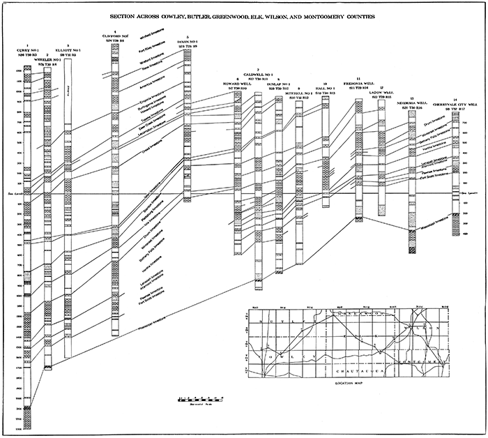
Numerous wells in Wilson and Montgomery counties have been drilled into the Mississippian limestone, but so far as known only two of these wells have penetrated to the bottom of this formation. The Neodesha deep well passed through 263 feet of Mississippian at a depth of 1,100 to 1,364 feet, and was drilled on to 2,412 feet (see plate IV). Practically all of the Mississippian consisted of light-colored cherty limestone, without a trace of sand. The sandstones found at greater depths were so fine grained and tightly cemented that they could hardly serve as oil and gas reservoirs. A well drilled near Caney in 1905 reached the Mississippian at about 1,600 feet, and was drilled on to 2,800 feet. Salt water and lack of funds prevented the well from going any deeper. It is reported that the bottom of this well was in a sandstone which showed considerable indication of oil. A pump was operated for a number of days in an attempt to exhaust the water, but succeeded in lowering the water only a few feet, The Cherryvale deep well was drilled 216 feet into the limestone, from 1,004 to 1,220 feet, also without a reported trace of sand (see plate IV). [Haworth, Erasmus, Kans. Univ. Geol. Survey, Special report on oil and gas, vol. 9, p. 66]
The surface of the Mississippian limestone is quite irregular in this region and dips to the west at the rate of about thirty feet per mile. A number of ridges and "domes" have been discovered by study of well records, all of which apparently represent pre-Pennsylvanian erosion rather than folding. It is reported that the Cherryvale anticline overlies a depression in the surface of the Mississippian, and that the syncline south of Independence coincides with a Mississippian ridge. [Schrader, F. C., U. S. Geol. Survey, Independence Quadrangle, folio 159, p. 5.] On the other hand, a careful study of well records in the Elk City gas field has shown the apparent surface structure overlies a very pronounced ridge of Mississippian limestone. [Boughton, Charles W., The Elk City Gas Field, Kan. Geol. Survey, Bull. 5, 1920.] To the west of this region the Mississippian has been found to contain one or more irregular sandstones, containing salt water and traces of oil and gas, and it is reported that important production of oil has been obtained from the Mississippian in Osage county and in Kay county, to the south in Oklahoma. [Aurin, F., Pre-Pennsylvanian oil and gas horizons in Kay county, Oklahoma, Bull. Am. Assn. Petrol. Geol., vol. 4, pt. 2, 1920.] It is very possible that deep tests in favorable areas in Wilson and Montgomery counties, Kansas, where essentially similar geologic conditions prevail, may find important production in the Mississippian.
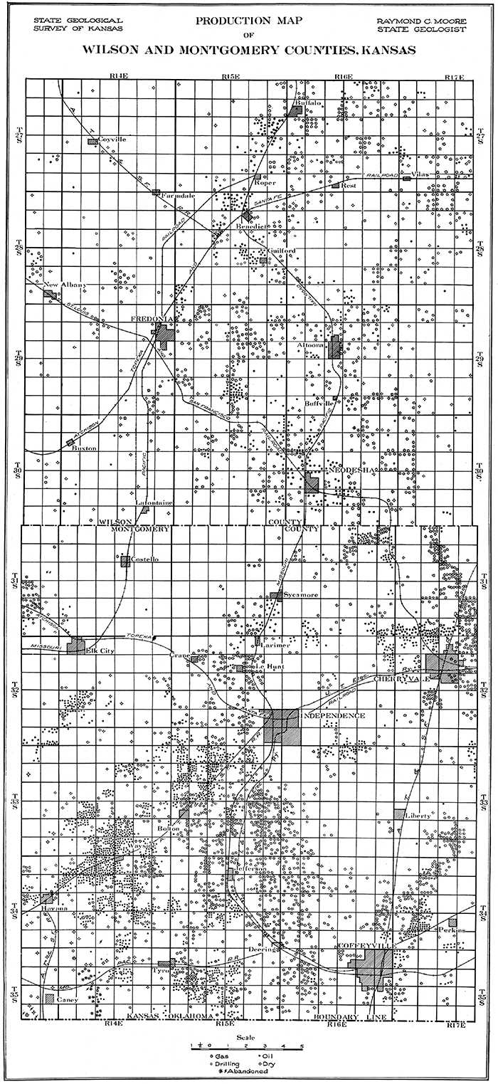
The chief producing districts in Wilson County are: (1) in the vicinity of Neodesha; (2) Altoona and the area northeast toward Neosho county; (3) the area surrounding Fredonia; and (4) the northern part of the county, including the territory about Roper, Benedict, and Buffalo. The distribution of oil and gas wells, dry and abandoned holes, so far as the data are available, is shown on the accompanying map, plate III. Records are very incomplete in parts of the area and it is certain that many more wells have been drilled than are represented on the production map.
Plate III--Production map of Wilson and Montgomery counties. [Larger version in PDF of the report.]
A survey of the distribution of oil and gas wells in Wilson County fails to indicate the presence of sharply differentiated natural-gas fields and oil fields. On the contrary, oil wells and gas wells appear to be closely associated in most of the fields in the county, and in many cases both oil and gas have been obtained from the same well. In a number of places gas is obtained from one sand and oil from another. The areas of most important gas production have been in the vicinity of Fredonia, about Neodesha and between Altoona and Vilas. Much of the gas in the region has been exhausted, but it is evident that all the resources of the county are by no means yet developed. The oil comes chiefly from fields near Neodesha between Benedict and Fredonia, and in the Benedict-Buffalo district. The wells are rather small producers, on the average, but yield a relatively high-grade paraffin base oil with a specific gravity of 33° to 38° Baumé. The average initial production is from ten to fifteen barrels, but the amount of daily yield soon settles to a very few barrels. As in most parts of southeastern Kansas, the wells have a long period of production, and in spite of their small yield are quite profitable. The producing sands are found at depths ranging from 350 feet in parts of the county, to 1,000 feet. Many of the wells have not been drilled through the Cherokee shale, and it is possible in a number of instances that deeper producing sands may be found. One well drilled at Neodesha gives a record of the geological formations beneath the surface to a depth of 2,412 feet. This, the deepest well in Wilson and Montgomery counties, reached the top of the Mississippian at a depth of 1,101 feet, its base at 1,364 feet, and drilled through sandstone, magnesian limestone, and dolomite of the Ordovician and Cambrian to 2,312, where it appears that granite was encountered. A diagrammatic log of this well appears on plate IV, well No. 13. Although this well did not obtain oil or gas beneath the Cherokee shale, it is not at all impossible that production may eventually be found under favorable structural conditions in "breaks" of the Mississippian, or even beneath this series, in a manner similar to recent discoveries in northern Oklahoma.
Plate IV--Geological cross section of correlated well records from Cherryvale, Montgomery County, west into Cowley County. [Larger version in PDF of the report.]
During the last few years from 100 to 300 new wells have been drilled in Wilson County each year. Although the proportion of dry wells has been only 9 to 12 per cent, the volume of production has not been so large as might be anticipated. This is mainly due to the average small size of the wells. However, the present high price of crude oil and the prospect of still higher prices, which results from the increasing demand for petroleum products and the diminishing reserve in other fields, is bringing renewed activity to the fields of Wilson County and adjacent parts of the southeast Kansas oil fields. In the future a much more intensive development and a wider prospecting may be anticipated in Wilson County.
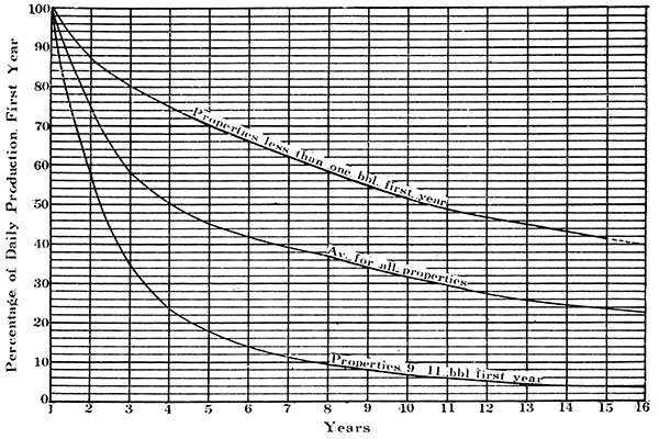
Figure 2--Composite decline curves for wells of different output in the Neodesha oil field (From Carl Beal, U. S. Bureau of Mines, Bull. 177.)
Development in the Neodesha area began about 1890, a number of good oil and gas wells being obtained immediately subsequent to this date. In 1903 and 1904 some wells were brought in which showed an initial daily production of more than 100 barrels. Production has in many cases been maintained for a period of ten to fifteen years, and it is possible under present conditions that a number of abandoned wells and territory could profitably be reopened.
The chief producing horizon is' a sandy bed of the Cherokee shale which is encountered in the vicinity of Neodesha at a depth of 800 to 900 feet beneath the surface. The geological formations which outcrop in southeastern Wilson County are older than those of other parts of the county, and it is consequently a shorter distance to any given horizon beneath the surface than in the other fields of the county.
The rate of decline in the production of oil wells in the N eodesha district has been studied by Carl H. Beal in work undertaken for the United States Bureau of Mines. [Beal, Carl H., Decline and ultimate production of oil wells, with notes on the valuation of oil properties, Bur. of Mines, Bull. 177, pp. 149-151, 1919.] Decline curves for the field, prepared by him, are shown in figure 2. In these curves the total production for the first year is taken as 100 per cent and the amount produced in each succeeding year is calculated in percentage on the basis of the first year's output. The upper curve (figure 2) shows the average decline of five properties in the Neodesha field in which the wells averaged Jess than one barrel daily the first year. The lower curve represents the composite decline of wells on three properties where the wells during the first year produced from nine to eleven barrels daily. The middle curve gives the average decline of all wells on properties for which production records were available. The first curve is of considerable interest, as it shows that a well with an average daily output of less than one barrel will average during the second year about 86 per cent of its first year's production. For wells that average nine to eleven barrels daily the first year, the second year's production will amount to about 57 per cent of that of the first. The average Initial production of the wells on fourteen properties from which the average curve was compiled amounted to 3.9 barrels daily during the first year.
One of the largest refineries in Kansas, that of the Standard Oil Company, is located at Neodesha. The first construction was undertaken in 1897, when a small refinery with a capacity of 500 barrels a day was erected. Additions have been made from time to time until at the present time the plant has a capacity of 12,000 barrels a day. Much of the oil of southwestern Kansas is now transported to this refinery.
In eastern and northeastern Wilson County, occupying the area about and between the towns of Altoona and Vilas, is an oil- and gas-producing district which for convenience may be designated the Altoona-Vilas field. It is essentially a gas field, which, especially during the last fifteen years, has contributed importantly to the production of this fuel in southeast Kansas. Gas was discovered here at a very early date by the Isett-Erwin Oil and Gas Company, who drilled one well which had an initial open-flow capacity of 20,000,000 cubic feet daily. Gas was not in demand at the time, and as attempts to find oil failed, the company disbanded. The present importance of the field dates from about 1906 or 1907, when renewed activity in prospecting resulted in the development of a number of remarkably good gas wells. Some of these have had an initial open-flow capacity of more than 30,000,000 cubic feet per day. At present there are a few small oil wells, some near Altoona, others in the vicinity of Vilas, but the quantity of oil obtained is not large. The production is chiefly from the Cherokee shale. The relation of the occurrences of oil and gas in the Altoona-Vilas field to geological structure has not been determined by the Survey.
The area included in the Fredonia field comprises the oil- and gas-producing territory in the vicinity of the city of Fredonia, extending east and southeast some five or six miles toward Altoona and Neodesha. There is no evident, sharply defined line of division between this and the fields near the latter towns, and the designation is hence largely one of convenience. Both oil and gas are obtained in the Fredonia field, production of gas being somewhat the more important. At least three oil and gas sands have been developed. The upper sand, found at a depth of 350 to 500 feet, yields gas. Many of the wells producing from this horizon have a daily open-flow capacity ranging from 1,000,000 to 3,000,000 cubic feet. In the fall of 1919 Stryker and Ladow developed a small field in this.sand, about five miles south of Fredonia. The gas was found at 380 feet and the initial test showed nearly 1,500,000 cubic feet open flow. Three gas wells were brought in, and the Fredonia Gas Company shortly laid a line from these wells to Fredonia. The second sand, which has long been an important oil producer, is encountered at a depth of 750 to 900 feet. It may be correlated tentatively with the Peru or Weiser sand of Chautauqua and Montgomery County fields. The initial production of wells in this sand has in some cases been as high as 150 barrels per day, but this has usually been due to an unusually heavy charge of nitroglycerine. The yield of such wells commonly declines within a month to 15 to 20 barrels. The third sand belongs to the Cherokee shale and varies in depth from 1,000 to 1,150 feet. This is probably the sand from which the excellent gas wells in the vicinity of New Albany, five miles west of Fredonia, have produced. Two typical wells in the Fredonia field are represented on Plate IV, Nos. 11 and 12.
Subsurface exploration south of Fredonia has determined the presence of a buried ridge of Mississippian limestone, or, as it is called by the drillers, a "Mississippi lime structure." It is highly probable that this ridge represents the results of pre-Pennsylvanian erosion, and our present knowledge of the Mississippian in this region would not warrant a test of this older series.
North central Wilson County, including the territory about the towns of Guilford, Benedict, Rest, Roper and Buffalo, has been a region of oil and gas development since 1900. The area, which may be called the Benedict-Buffalo field, adjoins the Fredonia and Altoona-Vilas fields on the south and southeast, and extends northward into southern Woodson county. The earliest development was just south of Benedict, near Verdigris river. For a number of years the chief producing horizon was an 800-foot sand, which yielded small but long-lived oil wells. In 1917 and 1918 the Dixie Oil and Gas Company drilled to a deeper sand, which was thought to be equivalent to the Bartlesville horizon. In sections 22 and 23, township 28 south, range 15 east, a number of oil wells with an initial production of 100 to 200 barrels per day have recently been drilled. The settled production of these ranges from 30 to 40 barrels a day. The record of new wells drilled in Wilson County, which has been maintained since 1904, is as follows:
| Table showing new wells completed in Wilson County, 1904 to 1919, inclusive. [Data from Mineral resources of the United States, U. S. Geol. Survey, and trade journals.] | ||||
| Year | Oil | Gas | Dry | Total |
|---|---|---|---|---|
| 1904 | 170 | 41 | 211 | |
| 1905 | 36 | 24 | 16 | 76 |
| 1906 | 7 | 48 | 26 | 81 |
| 1907 | 47 | 10 | 57 | |
| 1908 | 66 | 21 | 87 | |
| 1909 | 89 | 24 | 113 | |
| 1910 | 1 | 80 | 27 | 108 |
| 1911 | 2 | 65 | 27 | 94 |
| 1912 | 18 | 86 | 52 | 156 |
| 1913 | 40 | 54 | 45 | 139 |
| 1914 | 27 | 12 | 20 | 59 |
| 1915 | 6 | 13 | 4 | 23 |
| 1916 | 63 | 3 | 2 | 68 |
| 1917 | 137 | 21 | 22 | 180 |
| 1918 | 251 | 22 | 28 | 301 |
| 1919 | 158 | 12 | 33 | 203 |
The total and average initial production of these wells since 1911 is as follows:
| Table showing total and average initial production of 'Wells in Wilson County, 1911 to 1919, inclusive. | ||
| Year | Total initial production, barrels |
Average initial production, barrels. |
|---|---|---|
| 1911 | 35 | 17.5 |
| 1912 | 255 | 14.2 |
| 1913 | 342 | 8.6 |
| 1914 | 268 | 9.9 |
| 1915 | 35 | 5.8 |
| 1916 | 365 | 8.1 |
| 1917 | 1,596 | 11.6 |
| 1918 | 2,452 | 9.7 |
| 1919 | 2,719 | 17.2 |
The following table shows the amount of new production by months for Wilson County since January, 1916. [Data compiled from monthly field summaries of the Oil and Gas Journal.]
| Table showing new production in Wilson County by months, 1916-1919 inclusive, in barrels. | ||||
| 1916 | 1917 | 1918 | 1919 | |
|---|---|---|---|---|
| January | 35 | 91 | 120 | |
| February | 80 | 153 | 142 | |
| March | 80 | 167 | 87 | |
| April | 45 | 48 | 168 | 229 |
| May | 80 | 58 | 348 | 542 |
| June | 50 | 153 | 251 | 368 |
| July | 331 | 170 | 210 | |
| August | 65 | 130 | 395 | |
| September | 45 | 289 | 371 | 148 |
| October | 20 | 344 | 290 | 349 |
| November | 70 | 60 | 125 | 124 |
| December | 55 | 53 | 188 | 5 |
| Totals | 365 | 1,569 | 2,542 | 2,719 |
Montgomery County has long held a position as one of the most important of the oil- and gas-producing areas in Kansas. As indicated in a preceding paragraph, it was one of the first counties to report commercial production of these invaluable fuels, and in the period before the discovery of the rich Butler county pools it contributed very largely to the production total of the state. Originally centering about a few discovery districts, the county has now been so widely developed that the wells in one region are almost continuous with those in another. Division of the producing territory into separate fields, especially in the southern part of the county, is somewhat arbitrary. However, in part as a recognition of the earlier districts, and in part as a convenient basis for the present description, the following oil and gas fields may be identified: (1) Bolton, (2) Wayside-Havana, (3) Independence, (4) Tyro, (5) Caney, (6) Coffeyville, (7) Cherryvale, (8) Elk City, and (9) Larimer-Sycamore. The distribution of oil and gas wells, dry and abandoned holes, so far as data are available, in these fields, is shown on plate III.
Gas is mainly produced in the Elk City field, the north and south Independence fields, the northeast part of the Cherryvale field, and in the Coffeyville field. Wells with an initial open-flow daily capacity up to 86,000,000 cubic feet have been drilled, and large production from the county has been maintained for many years. The older fields, such as that near Independence, are largely exhausted and many wells have been abandoned.
Oil production is obtained mainly from the fields on the southwest part of the county, Bolton, Wayside-Havana, Caney and Tyro, and in part from the Coffeyville, Cherryvale and Larimer-Sycamore fields. Wells with an initial daily capacity of more than 1,000 barrels have been drilled in a number of places, but in most instances it is much less. The average initial daily production for the county has been 10 to 20 barrels. Some wells in the southwest fields have yielded 100 to 250 barrels settled production. Most of the "pumpers" do not produce more than 3 to 5 barrels daily. The oil ranges in quality from a heavy-grade specific gravity of about 22° Baumé to a good paraffin oil of about 38° or 39° Baumé. The better or lighter oils are found in the central west and southwest parts of the county, the poorer grades being reported from south of Independence and in the east part of the county.
A considerable number of new wells have been drilled each year, the large proportion of which have been oil wells. More than 900 new wells were drilled in 1914 and in both 1913 and 1916 the number was in excess of 860. Since the war the difficulty of getting casing has retarded development, but it may be anticipated that with a return to more normal conditions the large demand for petroleum products will bring renewed activity to Montgomery County fields.
The important oil-producing area just north of the town of Bolton, about six miles southwest of Independence, is known as the Bolton field. The first noteworthy development here was in 1901, when a number of good gas wells were drilled in. The first oil well was drilled by McBride and Bloom in the southwest quarter of section 18, township 33 south, range 15 east, on the Jeff Bolt land. The drill encountered the oil sand at 1,180 feet, and at 1,195 passed from sand to shale. The initial production of this well was approximately forty barrels per day. [Haworth, E., Kans. Univ. Geol. Survey, Special report on oil and gas, vol, 9, p. 87.] In a short time a number of oil wells had been drilled on the southeast quarter of section 17, each with an initial production exceeding 500 barrels daily. Some wells in the field have reported an initial daily production of as much as 1,000 barrels. The Standard Oil Company completed a pipe line from its Neodesha refinery to the Bolton field in the fall of 1903, and for the next two or three years this area was probably more active than any other in the Midcontinent field. In 1904 the Bolton field contained over 200 producing oil wells. At the present time the field is still producing, but new development is not active.
This field lies in the western part of Montgomery County, southwest of the Bolton field. It comprises several square miles on either side of the Santa Fe railroad between the towns of Wayside and Havana. Prospecting extended into this territory from the Bolton field in 1904. Both'oil and gas were discovered and the field is still an important producer. The oil is a high-grade paraffin oil with a specific gravity of about 36° to 38° Baumé, and though the production per well is in very few cases more than about twenty-five barrels per day, the producing life of the wells is very long. The gas wells have an initial open-flow capacity of about two million to four miilion cubic feet daily, an initial pressure of 265 pounds, and an average life of about five years.
The Stanton limestone is the surface formation over much of the Wayside-Havana field. The position of the outcrop of this limestone northwest of Wayside (see plate I) is strongly indicative of a local elevation of the rock strata in this region, but the structure has not been surveyed in the field. As indicated by the structure map of the Independence quadrangle (plate II) the area northwest of Wayside, where are located most of the oil wells of the field, is a broad structural flat or terrace. However, the data on which this map is based are hardly sufficiently precise to permit accurate determination of the structural conditions in the field.
Production in the Wayside-Havana field appears to come from four different stratigraphic horizons. The uppermost sand is the Wayside, which is found at an average depth of about 600 feet. It is one of the best sands in southeast Kansas from the standpoint of the long life of the wells producing from it. Approximately 125 feet below the Wayside is the Weiser sand, which produces a heavier oil than the upper sand. In stratigraphic position the Weiser appears to be equivalent to the Peru sand of Chautauqua county, but the Peru yields a much better grade of oil. The third horizon in the WaysideHavana field is the Bartlesville sand, which is found at a depth of 1,100 feet or more. This sand contains oil chiefly. The deepest sand is doubtless the Burgess horizon. [13. Moore, Raymond C., and Haynes, Winthrop P., Kans. Geol. Survey, Bull. 3, p. 342, 1917.] Much of the gas comes from this deep sand. Many of the wells in the fields produce from two or three sands at the same time.
The amount of gas marketed from the Havana district by the Southwestern Gas Company of Independence is as follows:
| 1915 | 534,191,000 cu. ft. |
| 1916 | 912,609,000 cu. ft. |
| 1917 | 396,485,000 cu. ft. |
| 1918 | 202,904,000 cu. ft. |
| 1919 (to October) | 15,424,000 cu. ft. |
The average rock pressure of seventeen gas wells in the Havana district, on August 10, 1917, was sixty-five pounds per square inch.
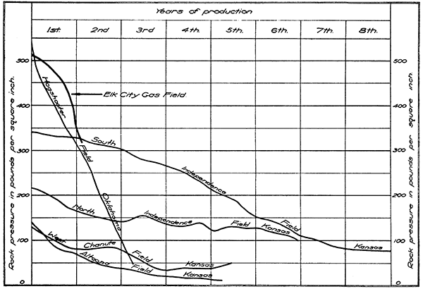
This field, comprising the territory mainly south of the city of Independence approximately to Jefferson, is a gas-producing district. Development began in 1903 and 1904, when a number of gas wells with initial openflow capacity ranging from twelve million to thirty-seven million cubic feet per day were brought in. In 1904 it is reported that the combined open-flow capacity of all the wells in the field then producing was about 700,000,000 cubic feet. [14. Haworth, E., loc cit., p. 37.] For a number of years the Independence gas field was not only the most important in Montgomery County, but one of the best in the state. The apparently unlimited supply of cheap natural gas brought many industries to Independence, Cherryvale and Coffeyville. The population of these and other cities of eastern Kansas used the gas for domestic purposes and the numerous industrial consumers used it in their plants, but in spite of the enormous quantity of gas consumed, the supply diminished only gradually. The decline of the pressure in the Independence field is shown in figure 3.
Figure 3--Diagram showing the comparative decline in rock pressure in important southeast Kansas and Oklahoma gas fields.
At the present time very many of the wells have "gone to water" and the rock pressure has declined to less than 100 pounds. Gas is still produced, but not in sufficient quantity to supply even the needs of the immediate vicinity. Gas is imported from the Oklahoma fields for consumption in parts of Montgomery County. It is, of course, well recognized by all who are familiar with the production of natural gas that this extremely valuable fuel is not an inexhaustible resource. The wise conservation of our remaining supply is a vital consideration, not only for the benefits to the present generation, but to the future population of the state. Notwithstanding the importance of industries which are using natural gas, the consumption of large quantities of gas at low rates in industrial plants diminishes the available supply for domestic use to such a degree that consideration may well be directed to the problem of future supply for domestic use. With an inevitable decline of natural gas production in the Midcontinent fields, the domestic consumer may anticipate an increase of cost which will make the price of the gas seem prohibitive. Eventually the supply will be gone. It is possible that some new gas wells may be drilled in parts of the Independence field, but for the most part the field is practically exhausted.
The Independence field is located on the nearly level shale area between the escarpments of the Drum and Stanton limestones (plate I). The structure has not been determined by field surveys but a generalized representation of the structure, in so far as determinable from the Independence quadrangle geological map of the United States Geological Survey, is indicated in plate II. This shows a structurally high area crossing the city of Independence in a northeast-southwest direction and a slight depression south of Independence. This does not, apparently, follow the distribution of production, for gas has not been developed northeast of Independence and there have been numerous good gas wells south of the town in the area indicated as structurally lower than the surrounding territory. A determination of the structure in the field from a study of the sand records and from field work is desirable but has not been accomplished by the Geological Survey.
The producing sands in the Independence field are found at average depths of about 700 and 1100 feet. They are probably the Weiser and Bartlesville sands.
An area of oil and gas production near the Oklahoma state line adjacent to the town of Tyro, on the Missouri Pacific railroad, is known as the Tyro field.
The discovery well in this field was drilled during the winter of 1903-04, about 200 yards east of the railway station in Tyro. During the following year development extended southward and one of the best wells in the field was brought in on a lease in section 16, township 35 south, range 15 east, within 100 feet of the Oklahoma boundary. [Schrader, F. C., and Haworth, E., U. S. Geol. Survey, Economic geology of Independence quadrangle, Bull. 296, p. 22, 1906.] The producing sands in the Tyro district are found at depths of about 1,000 and 1,300 feet.
Oil and gas production in the extreme southeast corner of Montgomery County in the vicinity of the town of Caney may be included in the Caney field. Gas was discovered northwest of Caney in 1901 in a sand encountered at a depth of 1,480 feet. The well had an initial open-flow capacity of 14,500,000 cubic feet daily, under 660 pounds rock pressure. [Haworth, E., Kans. Geol. Survey, Min. resources of Kansas, p. 56, 1900-01.] The producing sands in the vicinity of Caney correspond to those found at Wayside and Havana. Much of the gas comes from the Burgess horizon, found at a depth of 1,660 feet. Many of the gas wells have an initial capacity of 30,000,000 cubic feet, under 600 pounds rock pressure.
The Coffeyville field, comprising the territory about the town of Coffeyville, and extending several miles west, northwest and northeast, is one of the oldest oiland gas-producing districts in southeastern Kansas. Originally it was exclusively a gas field, no attention being paid to oil. The first wells were very shallow, only 350 to 400 feet deep, and because of the light rock pressure were soon exhausted. In a few years, however, sands at depths of 600 and 900 feet were developed. Oil production has been obtained in various parts of the Coffeyville field. The wells are small and in most cases do not have a settled production of more than ten barrels. Tests of the oil which have been reported show a specific gravity ranging from 280 to 340 Baumé. [Day, David T., Petroleum, U. S. Geol. Survey, Mineral resources of the United States, 1913, pt. II, pp. 1191-8.] The oil has a paraffin base.
The Cherryvale field includes the area of oil and gas production in the northeast corner of Montgomery County and extending into Labette County. Gas was first developed in the field by the Cherryvale Gas Company and the Edgar Zinc Company. The gas is now practically exhausted, the local factories being supplied with gas from the Elk City field. Oil was found northwest of Cherryvale in 1904, many of the wells reporting an initial production of 50 to 100 barrels per day. The chief producing sand is found at a depth of 700 to 800 feet in the upper part of the Cherokee shale. The record of a typical well in the Cherryvale field is shown on plate IV, well No. 14. The pool directly north of Cherryvale in September, 1920, contained 128 producing oil wells.
In August, 1920, a new oil pool was discovered about fourteen miles northeast of Cherryvale, near the town of Morehead, in Neosho county. Twenty-six feet of sand was encountered at 700 feet, and the initial production of the first well was slightly over fifty barrels per day.
The Elk City gas field. In November, 1917, the Oliver Oil Company drilled a well in the northwest quarter of section 35, township 31, range 13, directly west of Elk City. The drill encountered the Bartlesville sand at 1,360 feet, and after being shot with a heavy charge of nitroglycerine produced over 100 barrels daily. The well was soon drowned by salt water, and although additional wells were drilled, the total production from this section was of little importance. Subsequent developments have shown that these wells were on the edge of the Elk City gas field, which is at present the most important gas-producing area in southeast Kansas. The discovery well in the gas field was drilled by the Elk Valley Syndicate on the Simmons farm, in the northeast quarter of section 27, township 31 south, range 13 east, in Elk county. The initial openflow capacity of this well was 10,000,000 cubic feet under a rock pressure of 520 pounds. Development immediately extended in all directions, and it was soon found that section 26 in Montgomery County was equally as good as the area in Elk county. The producing area in the Elk City field is slightly more than three and one-half square miles, and at present contains about fifty producing wells. These wells range in openftow capacity from 1,500,000 to 86,000,000 cubic feet of gas daily. The field is at present controlled by the Southwestern Gas Company of Independence and the Hale Oil and Gas Company of Neodesha. [Boughton, Charles W., Elk City gas field, Kans. Geol. Survey. Bull. 5, 1920.]
During May and June, 1920, a small oil pool was developed along the Missouri Pacific railway between Larimer and Sycamore, due north of Independence. Up to the middle of June about fifteen wells had been drilled, all of which were productive. What is believed to be the Bartlesville sand was encountered at 1,000 to 1,070 feet, with a thickness varying from 18 to 50 feet. It is reported that the wells pump about 60 barrels daily after being shot with nitroglycerine. The oil tests 38° Baumé gravity. [Oil and Gas Journal, June 11, 1920, p. 46.]
Records of development in Montgomery County. The number of wells drilled in Montgomery County since 1904, when complete data were gathered for the first time, is as follows:
| Table showing new wells drilled in Montgomery County, 1904 to 1919, inclusive. | ||||
| Year | Oil | Gas | Dry | Total |
|---|---|---|---|---|
| 1904 | 715 | 113 | 828 | |
| 1905 | 104 | 89 | 40 | 233 |
| 1906 | 60 | 88 | 21 | 169 |
| 1907 | 21 | 31 | 4 | 56 |
| 1908 | 1 | 79 | 17 | 97 |
| 1909 | 5 | 100 | 22 | 127 |
| 1910 | 16 | 56 | 7 | 79 |
| 1911 | 60 | 36 | 22 | 118 |
| 1912 | 202 | ll6 | 47 | 365 |
| 1913 | 602 | 173 | 92 | 867 |
| 1914 | 691 | 137 | 75 | 903 |
| 1915 | 201 | 129 | 49 | 379 |
| 1916 | 778 | 34 | 48 | 860 |
| 1917 | 336 | 27 | 78 | 441 |
| 1918 | 334 | 28 | 95 | 457 |
| 1919 | 182 | 41 | 47 | 270 |
The following table shows the amount of new production, by months, for Montgomery County since January 1, 1916.
| Table showing new production in Montgomery County by months, 1916 to 1919, inclusive, in barrels. | ||||
| 1916 | 1917 | 1918 | 1919 | |
|---|---|---|---|---|
| January | 620 | 320 | 269 | 75 |
| February | 691 | 328 | 61 | 219 |
| March | 795 | 523 | 334 | 37 |
| April | 841 | 276 | 337 | 102 |
| May | 1,212 | 597 | 427 | 133 |
| June | 1,535 | 427 | 627 | 106 |
| July | 1,259 | 705 | 288 | 140 |
| August | 821 | 403 | 304 | 136 |
| September | 905 | 235 | 230 | 512 |
| October | 365 | 396 | 114 | 513 |
| November | 695 | 275 | 259 | 334 |
| December | 465 | 389 | 81 | 212 |
| Totals | 10,204 | 4,874 | 3,331 | 2,519 |
Six active refineries are located in Wilson and Montgomery counties, one of them, the Standard Oil Company refinery at Neodesha, being much the largest, as it is the oldest in Kansas. Not only is most of the oil produced in the local fields treated by these refineries, but much of the production from adjacent counties in Kansas and northern Oklahoma. The following list shows the distribution, date of construction and the daily capacity of these refineries.
| Refineries in Wilson and Montgomery counties. | ||
| Company and location | Year built |
Daily capacity, bbls. |
|---|---|---|
| Empire Refineries, Inc., Independence | 1919 | 2,500 |
| Kansas Oil Refining Company, Coffeyville | 1906 | 1,800 |
| National Refining Company, Coffeyville | 1907 | 4,000 |
| Sinclair Refining Company, Coffeyville | 1919 | 5,000 |
| Standard Oil Company (Kansas), Neodesha | 1897 | 12,000 |
| Uncle Sam Oil Company, Cherryvale | 1906 | 1,500 |
| Wright Producing and Refining Company, Cherryvale | 1917 | Idle |
Kansas Geological Survey, Oil and Gas Resources of Kansas; Wilson and Montgomery Counties
Placed on web April 4, 2014; originally published in 1921.
Comments to webadmin@kgs.ku.edu
The URL for this page is http://www.kgs.ku.edu/Publications/Bulletins/6_6/index.html