Kansas Geological Survey, Bulletin 6, pt. 5, originally published in 1920
Originally published in 1920 as Kansas Geological Survey Bulletin 6, part 5. This is, in general, the original text as published. The information has not been updated. An Acrobat PDF version (11.6 MB) is also available.
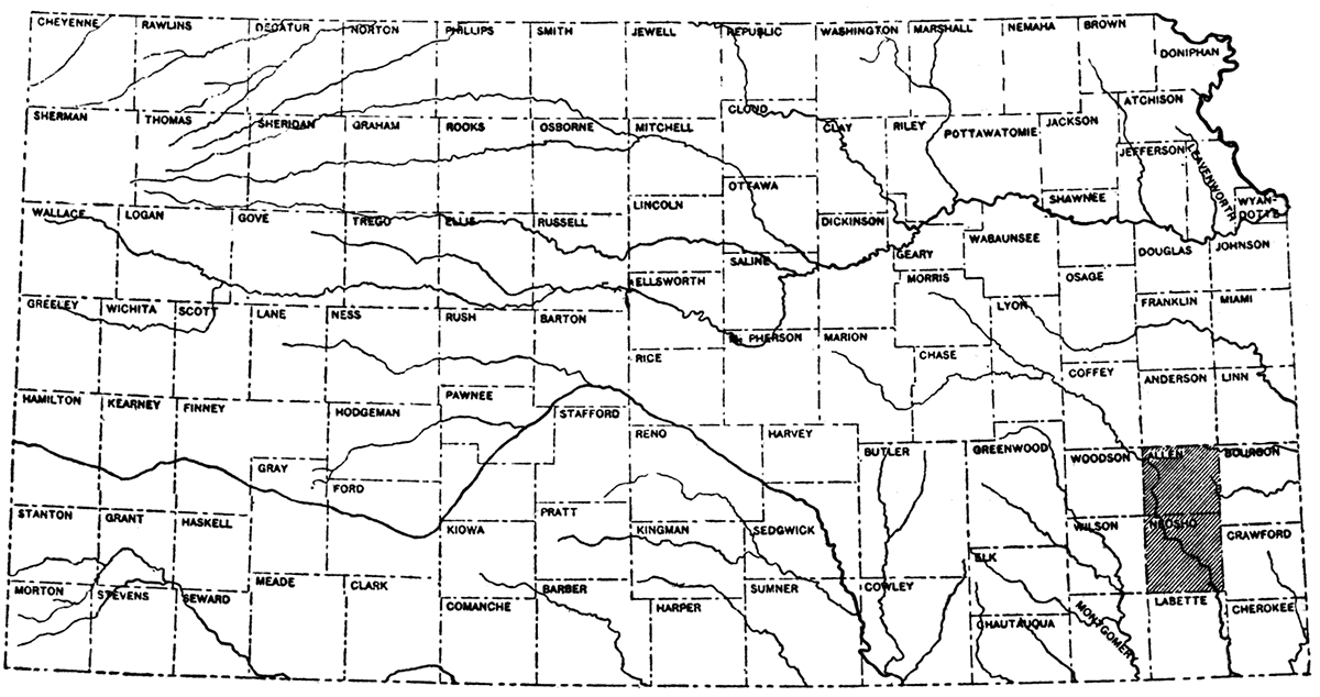
Allen and Neosho counties are situated in the southeastern portion of Kansas, separated by the width of a single county both from the east and south boundaries of the state (figure 1). Together they form a rectangle about 23 miles in an east-west direction, by 45 miles in a north-south direction. The combined area of the counties is about 1,080 square miles. Owing to the similar conditions existing in Allen and Neosho counties, they may conveniently be discussed together.
Figure 1—Location map of Allen and Neosho counties.
Allen and Neosho counties lie within the area of scarped plains which extends throughout most of eastern Kansas and a large portion of adjoining states. The country is a rolling plain, the chief features of which are the east-facing escarpments which are formed by the harder rock strata and the more or less broad river valleys which have been carved beneath the general level of the region. The escarpments may be traced across the counties in very irregular lines which trend in a general southwest-northeast direction. Some of them, as locally that of the Iola and of the Drum limestones, are very prominent. Others are less well defined and in places grade into nearly flat or gently rolling topography in which the outcrops of the harder rocks cannot easily be traced. Above the escarpments there are commonly areas of nearly level or slightly west-sloping country which are formed by the hard beds which are gently inclined to the west, just beneath the surface. Such a prominent dip slope is that above the Iola limestone east of Humboldt and southeast of Iola. The larger streams have flat-bottomed, alluvium-filled valleys varying in width from one to three or four miles, the sides in many places bordered by steep bluffs 100 to 200 feet high.
The largest stream in the area is Neosho river, which flows south across the extreme western portion of Allen County, and from northwest to southeast across the central portion of Neosho County. Almost all of the secondary drainage of the two counties is tributary to the Neosho. Streams in the northeast corner of Allen County flow eastward into Osage river, and in southwestern Neosho County into the Verdigris.
Allen and Neosho counties contain much fertile farm land and important industrial centers. The area is therefore comparatively thickly settled. The most important towns, are, in Allen County, Iola, Moran and Humboldt; in Neosho County, Chanute and Erie. Large cement and brick plants are located at Iola. Chanute contains two refineries and is an important railroad point. To the development of oil and gas in this region much of the prosperity of all the towns in the district is due.
Intersecting lines of three railroad systems, the Atchison, Topeka & Santa Fe, Missouri Pacific, and Missouri, Kansas & Texas cross Allen and Neosho counties from north to south and east to west, so that almost all parts of the oil and gas fields are readily in touch with excellent railroad facilities. A network of good automobile and wagon roads extends over all parts of the counties and is easily traversable except locally along some of the escarpments and after heavy rains.
The survey is indebted to the Empire Fuel and Gas Company for reference to their geological outcrop maps of this area and for the use of a number of measured stratigraphic sections. The account of early development in Allen and Neosho counties is mainly drawn from Haworth's report on the oil and gas resources of Kansas, published in 1908 [Haworth, Erasmus, Special Report on Oil and Gas; Kan. Univ. Geol, Survey, vol. 9, 1908, pp. 29, 35].
The first discovery of gas in the area under consideration was at Iola, in 1873, when the Acers well was drilled. A number of wells were drilled in the vicinity of Iola a short time later and a sufficiently large gas field was developed to supply all the needs of the town. On account of the abundant supply of this fuel, which has been produced from the Iola field in the last twenty-five years, a number of important industries have been located at Iola.
The first active prospecting in the vicinity of Humboldt was in 1894 and 1895, when Guffey and Galey drilled a number of wells north and south of the town. These wells found a considerable amount of gas and some oil. The Humboldt field has not been so important as a gas producer as that near Iola, but it has yielded much more oil.
Wells were drilled by Guffey and Galey in the vicinity of Chanute in 1894, but they were dry and the territory was for a time abandoned. Later the city of Chanute drilled wells which found a good supply of gas, and in a short time more than sufficient gas to supply the town was developed. In 1899 a successful attempt to find oil near Chanute began the oil production of the Chanute field. This area has been an important one in the oil production of Kansas.
The development of oil and gas in other parts of Allen and Neosho counties has followed the initial discoveries in the main fields mentioned. Good production has been obtained over much of the two counties and, though the oil and gas yield of the older fields has declined in recent years, new productive areas have been found. It is apparent from tests which are now being made that not only may new production be found in undeveloped portions of the counties, but deeper drilling in parts of the old fields may yield important results. From 500 to 700 new oil wells have been brought in each year since 1915.
Plate I—Geologic map of Allen and Neosho counties, Kansas.
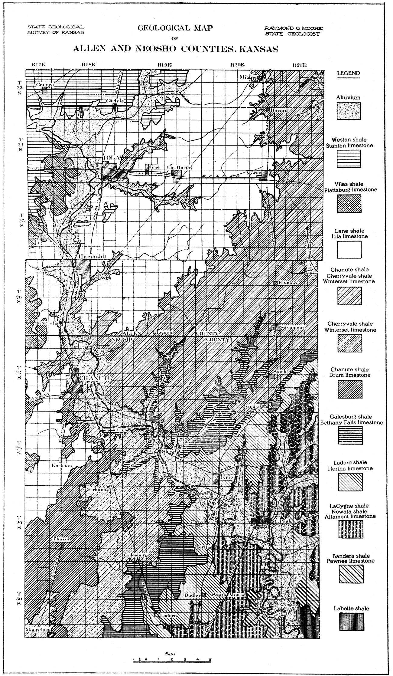
The rocks of Allen and Neosho counties belong to the middle portion of the Pennsylvanian system. They consist of alternating beds of limestone and shale, and, locally of some sandstone. The limestones form more or less prominent escarpments which cross the area in a general direction from northeast to southwest. On account of the erosion of Neosho river and its tributaries the outcrop of the formations, and consequently the position of the escarpments, is extremely irregular (see geologic map, plate I). The shales, which are very readily weathered, form the slopes beneath the limestone escarpments and much of the gentle rolling country back of the limestone outcrops.
The geologic divisions which are exposed at the surface in Allen and Neosho counties are the Marmaton, Kansas City, Lansing and part of the Douglas formations. The relation of these divisions to other parts of the Pennsylvanian in Kansas and the members of which they are composed, are shown in the table [below]. The divisions are arranged in the order in which they appear geologically, the lower formations below and the upper, above.
| Table showing geological divisions of Allen and Neosho counties, and their relation to other rock formations of Kansas | ||||
|---|---|---|---|---|
| Quaternary | ||||
| Recent | ||||
| Alluvium (includes deposits along streams in Allen and Neosho counties) | ||||
| Pleistocene | ||||
| Glacial deposits (northeastern Kansas) | ||||
| Tertiary (western Kansas) | ||||
| Cretaceous (western and north-central Kansas) | ||||
| Comanchean (south-central Kansas) | ||||
| Permian (central Kansas) | ||||
| Pennsylvanian (eastern Kansas) | ||||
| Missouri group | ||||
| Wabaunsee formation | ||||
| Shawnee formation | ||||
| Douglas formation | ||||
| Oread limestone | ||||
| Lawrence shale | ||||
| Iatan limestone | ||||
| Weston shale | Exposed in Allen and Neosho counties | |||
| Lansing formation | ||||
| Stanton limestone | ||||
| Vilas shale | ||||
| Plattsburg limestone | ||||
| Lane shale | ||||
| Kansas City formation | ||||
| Iola limestone | ||||
| Chanute shale | ||||
| Drum limestone | ||||
| Cherryvale shale | ||||
| Winterset limestone | ||||
| Galesburg shale | ||||
| Bethany Falis limestone | ||||
| Ladore shale | ||||
| Hertha limestone | ||||
| Marmaton formation | ||||
| La Cygne shale | ||||
| Lenapah limestone | ||||
| Nowata shale | ||||
| Altamont limestone | ||||
| Bandera shale | ||||
| Pawnee limestone | ||||
| Labette shale | ||||
| Fort Scott limestone | ||||
| Cherokee shale | ||||
| Mississippian | ||||
| Devonian and Silurian? | Not exposed in Kansas | |||
| Ordovician | ||||
| Cambrian | ||||
| Pre-Cambrian | ||||
The Marmaton formation outcrops in the southeastern portion of Neosho County. The Kansas City formation, which lies next above the Marmaton, may be traced from southern Neosho County northward along the valley of Neosho river as far as Iola in Allen County and northeastward across all of southern and eastern Allen County. It is much the most widespread of the formations in Neosho County. The Kansas City formation is mainly characterized by the abundance of limestone beds, and the area in which it constitutes the surface formation is essentially a limestone country. The Hertha limestone at its base forms a prominent escarpment in southeastern Neosho County, crossing Neosho river near the town of Erie. Other clearly defined escarpments are those of the Drum and Iola limestone members, the former in western Neosho and southeastern Allen counties, the latter west of Thayer and Chanute in Neosho County, and northward on either side of Neosho river in Allen County as far as Iola; and northeastward from a point south of Humboldt to Moran and the northeast corner of the county. The Lansing formation occupies a small area west of the Iola escarpment in western Neosho County and a large portion of northwestern Allen County. Its most prominent member is the Stanton limestone, which forms an escarpment along the west line of Allen County. Unimportant outcrops representing the lower part of the Douglas formation occur above the Stanton in the extreme west and northwest parts of Allen County.
The table [below] shows the thickness of the geologic divisions in various parts of Allen and Neosho counties observed by geologists of the Empire Fuel and Gas Company.
| Geological Sections in Allen and Neosho Counties (thicknesses in feet) |
|||||||||||
|---|---|---|---|---|---|---|---|---|---|---|---|
| T. 30 S. R. 17 E. |
T. 29 S. R. 19 E. |
T. 29 S. R. 18 E. |
T. 29 S. R. 17 E. |
T. 27-28 S. R. 19 E. |
T. 27-28 S. R. 18 E. |
T. 26 S. R. 20 E. |
T. 26 S. R. 19 E. |
T. 26 S. R. 18 E. |
T. 25 S. R. 18 E. |
T. 23-24 S. R. 19 E. |
|
| Lansing formation: | |||||||||||
| Stanton limestone | 30 | ||||||||||
| Vilas shale | 30 | ||||||||||
| Plattsburg limestone | 20-50 | 7 | |||||||||
| Lane shale | 94-127 | 38 | 38 | 51 | 125 | ||||||
| Kansas City formation: | |||||||||||
| Iola limestone | 10 | 1-6 | 2-20 | 40 | 30 | 30 | 30-45 | 40 | |||
| Chanute shale | 44-64 | 60 | 52 | 40-60 | 34 | 25-30 | |||||
| Drum limestone | 50? | 1-3 | 1-3 | 6-8 | 35? | 95* | 95* | 4-12 | |||
| Cherryvale shale | 60 | 43-78 | 31 | ||||||||
| Winterset limestone | 25 | 30-50 | 46-55 | 30-42 | |||||||
| Galesburg shale | 10-65 | 15-20 | |||||||||
| Bethany Falls limestone | 8-10 | ||||||||||
| * Drum limestone not found. | |||||||||||
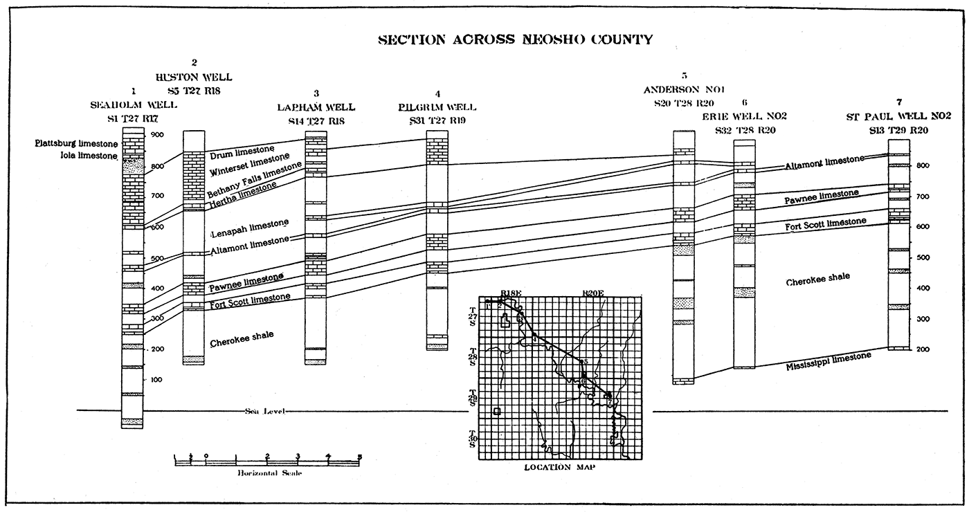
The general dip of the rock strata in Allen and Neosho counties is to the west and northwest, at the rate of about 12 to 15 feet to the mile. The State Geological Survey has not yet been able to make a detailed examination of the structure in this area, but it is known that there are a number of slight variations from normal west or northwest dip. However, the production of oil and gas in these counties does not appear to be governed wholly by the structure of the rocks in which they are found. As in other parts of the mid-continent field, it is very desirable in drilling test wells to secure as favorable location with reference to structure as possible. Hence it is very desirable to have accurate structural maps of the entire area. Plates II and III show the general character of the rock strata beneath the surface in Allen and Neosho counties as represented by typical well logs.
Plate II—Section across Allen County.
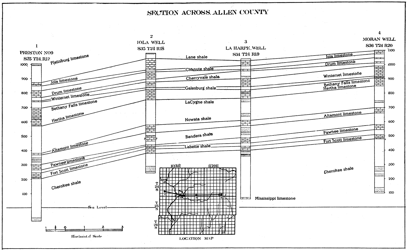
Plate III—Section across Neosho County.
The character of the formations beneath the surface in the area under consideration is very important to the prospector for oil and gas and the producer. The presence, extent and lithologic nature of porous beds beneath the surface, which may serve as a reservoir for oil or gas, are subjects of chief interest. Information concerning these is available in part from a study of the outcrop of the formations which in these counties are .buried, and in part from data secured from drill records. The general character of the buried formations may be inferred from their characters as seen at the outcrop, but since the outcrop is in, some instances many miles distant from the area, such as Allen and Neosho counties where they are buried, there may be noteworthy changes in many respects. Information from well logs is valuable in proportion as the record is carefully made and correctly interpreted. From a good well record it should be possible to identify the buried geological formations and determine their essential characters. It is very desirable in, almost all cases for the purposes of geologic study of subsurface conditions to secure samples of the drill cuttings at intervals of every few feet.
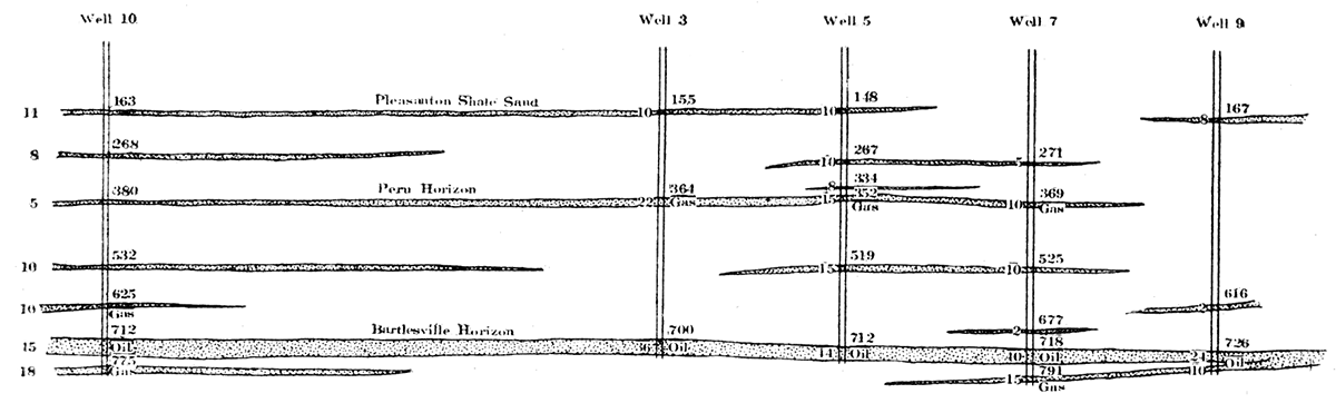
Records of typical wells in the Allen and Neosho county fields show that there are a number of good producing oil and gas sands, the most important of which are in the Cherokee shale. A study of the logs indicates that most of the sands are lenticular in shape, in some cases thick sands pinching out in surprisingly short distances, or that they grade laterally into shale. The non-persistent character of some of the sands in this region is shown in figure 2, which shows partial logs of wells just east of Chanute.
The following table shows the depth of the producing sands in a number of typical wells and their initial production:
| Record of Producing Sands in Allen and Neosho Counties | |||||
|---|---|---|---|---|---|
| Location | Depth to producing sand, feet |
Thickness penetrated, feet |
Initial production |
||
| Section | Twp. | Range. | |||
| 35 | 24 | 18 | 855 | 85 | Gas |
| 35 | 24 | 18 | 792 | 35 | Oil |
| 9 | 25 | 18 | 630 | ||
| 11 | 25 | 18 | 617 | 14 | Oil |
| 4 | 26 | 18 | 775 | 18 | Oil |
| 4 | 26 | 18 | 795 | 7 | Oil |
| 4 | 26 | 18 | 864 | 14 | Oil |
| 20 | 26 | 18 | 816 | 27 | Oil |
| 22 | 26 | 18 | 755 | 8 | Oil |
| 22 | 26 | 18 | 790 | 43 | Oil |
| 22 | 26 | 18 | 776 | 7 | Oil |
| 22 | 26 | 18 | 798 | 28 | Oil |
| 22 | 26 | 18 | 767 | 10 | Oil |
| 22 | 26 | 18 | 804 | 28 | Oil |
| 26 | 26 | 18 | 764 | 8 | Oil |
| 26 | 26 | 18 | 834 | 14 | Oil |
| 26 | 26 | 18 | 798 | 25 | Oil |
| 26 | 26 | 18 | 823 | 13 | Oil |
| 26 | 26 | 18 | 808 | 13 | Oil |
| 26 | 26 | 18 | 835 | ||
| 27 | 26 | 18 | 833 | 5 | |
| 27 | 26 | 18 | 644 | 12 | |
| 27 | 26 | 18 | 872 | 12 | Gas, 1000 M cu. ft. |
| 16 | 26 | 20 | 685 | ||
| 34 | 26 | 20 | 780 | Oil, 35 bbls | |
| 25 | 27 | 17 | 890 | 20 | Oil, 12 bbls, |
| 36 | 27 | 17 | 893 | 17 | |
| 14 | 27 | 18 | 748 | 17 | |
| 29 | 27 | 19 | 698 | 12 | |
| 747 | 28 | ||||
| 6 | 28 | 19 | 735 | Oil, 150 bbls. | |
| 20 | 28 | 20 | 550 | 35 | |
| 28 | 19 | 750 | 28 | Oil, 35 bbls. | |
Among the most interesting of the well records from this part of the state is that of a deep well drilled in S. 24, T. 24, R. 18, at Iola. It reached a total depth of 3,434 feet, but according to samples which were secured, and which are now filed in the office of the Geological Survey, the well did not reach granite. Since a well recently drilled near Yates Center, Woodson county, not more than twenty miles distant, encountered granite at a depth of 2,585 feet, there is apparently a slope of the granite surface toward the east in this area which amounts to nearly 1,000 feet in 20 miles. So far as known the greater thickness of sedimentary rocks beneath the surface in the vicinity of Iola, and probably the adjacent parts of Allen and northwest Neosho County, does not have a significant bearing on the accumulation of oil and gas in the area. It is interesting, however, to observe that the oil and gas fields of the two counties lie above the east-sloping granite (and east-dipping lower sedimentary rocks), while on the west side of the granite, at Yates Center, there has been very little production until the Butler County fields far to the west, which are also associated with an uplifted portion of the granite, are reached.
The chief producing fields in Allen and Neosho counties are in the vicinity of Iola, Humboldt, Chanute and Erie. The distribution of oil and gas wells, dry and abandoned holes, so far as the data are available, is shown on the accompanying map, plate IV.
Production of natural gas has, in the past, been most important in the Iola and parts of the Chanute field. At present there is larger production of gas near the towns of La Harpe and Gas in Allen County. The amount of gas obtained from wells in this region has steadily diminished in recent years despite the drilling in of good new gas wells in parts of the field. Near Iola very many wells have been abandoned. It appears that in part of this area at least good new supplies of gas may be obtained by drilling between old locations, or in some cases by drilling to deeper sands. Most of the available supply of natural gas in these fields has, however, been exhausted and both domestic and industrial consumers are finding it necessary to draw upon supplies from other sources.
The oil produced in Allen and Neosho counties comes chiefly from the fields about Chanute, Humboldt, Moran, and Erie. The wells are rather small producers, on the average, and yield a relatively heavy oil, much of it below 25 degrees Baumé gravity. The average initial daily production is about 25 barrels, but some wells have an initial production of 250 barrels or more. After a few months the production settles to 5 to 20 barrels per day. In most parts of the area the wells have an unusually long life, in some cases producing for as long as twenty or more years. The producing sands are found at shallow depths, 600 to 1,000 feet below the surface. The average depth of the important sands is about 600 and 800 feet, respectively. Many of the wells have not been drilled through the Cherokee shale and it is possible in some to test deeper sands. So far as reported, only one well, that at Iola, has been drilled deep into or through the Mississippian. Whether production of oil from breaks in the limestone of this system in Allen and Neosho counties is possible is yet unknown. The discovery of large quantities of oil in the Mississippian south and west of this area makes desirable the testing of conditions in favorable structure in southeastern Kansas.
Although from 500 to 700 new oil wells have been brought in each year in these counties for the past four or five years, the total production has not been as large as might be expected. This is partly due to the average small production per well and partly to the low gravity of the oil. Recently, on account of the increasing demand for petroleum products and the diminishing reserve in other fields, the price of the heavy crude has advanced. The Standard Oil Company has offered $1.87 per barrel for oil between 10 and 26 gravity Baumé and has provided for advances in the price of low grade oil amounting to 50 per cent of the advances in the price of high grade oil. This will make possible the profitable operation of many wells which have been idle and will bring to the oil fields of the entire district renewed activity, As the demand for crude oil becomes larger, much of the possible oil-producing territory in these and adjacent counties will be prospected and known fields will be more intensively developed. The importance of the shallow fields of Allen and Neosho counties is, therefore, by no means entirely a matter of history.
The Iola field comprises the area about the town of Iola, including especially the country north and east, as far as Gas and La Harpe. Production has chiefly consisted of natural gas. The Iola field has been, indeed, one of the most important gas fields in Kansas and still supplies most of the local demand, which includes large industrial consumers. Some of the gas wells have produced more than 25,000,000 cubic feet per day. An important gas-producing area at the present time covers about ten square miles between Iola and Carlile and another lies between Iola and La Harpe. The relatively rapid decline of the gas fields near Iola is chiefly due to the unnecessarily large consumption of domestic consumers in the early years of the field when it was assumed that the supply of gas was inexhaustible, and to the large demands of industrial users. It is important that the remaining supply be developed as conservatively as possible. It is now generally realized that natural gas, the most valuable of all the natural fuels, is a very readily exhaustible substance and that when used or lost the supply is permanently decreased. In view of this fact it may be anticipated that the price of natural gas in the Iola and other gas fields of the state will increase until the cost equals that of artificially produced gas. Since natural gas has many times greater heat efficiency than artificial gas there is need both for the greatest practicable economy of consumption of the natural gas resources of the state and for the most efficient possible development of old and new gas fields.
A small amount of oil is produced in the Iola field, the oil wells being located chiefly in the valley of Neosho river west of Iola and along Deer creek, some four miles north of the town. The production of these wells is not large, probably not averaging more than 10 barrels per day.
In the vicinity of Moran, in eastern Allen County, there are two. productive areas which may be considered under the name of the Moran field. One of the areas extends from the west edge of Moran westward and slightly south to within three miles of La Harpe. The other, which has been developed more recently, lies about four miles east of Moran and trends in a direction slightly north of east to south of west. The development of this oil field began about 1903 and production has been maintained to the present time. Since the formations are not so deeply buried in this part of the area as farther west, the oil is obtained at shallower depths than at Iola and Chanute. The amount of oil obtained from each individual well is small and the oil is heavy, like that at Humboldt and Chanute.
A productive area which for convenience may be designated as the Humboldt field, covers a considerable portion of southwestern Allen County in the vicinity of the town of Humboldt. To the north, production has been extended until it practically joins the southeast extension of the Iola field. Southward the productive area expands toward the county line and unites with the Chanute field. Although the portions north and south of the county line are, as at present developed, parts of a single productive area in which essentially the same geological and development conditions obtain, the Allen County area may be included in the Humboldt field and the Neosho County area in the Chanute field, The most active early drilling in the Humboldt field was in 1903, operations extending southward from Humboldt. Drilling was at first centered chiefly in the Neosho river valley, but wells have later been drilled both east and west of the river until at the present time the field is more than nine miles wide. The wells in the Humboldt field are rather small but fairly long-lived producers. The oil is heavy, ranging from about 12 to 30 Baumé. Very little gas is produced in the area. The average depth of the producing sands in the Cherokee shale is from 800 to 900 feet.
A large area in northwestern Neosho County, which has for many years produced oil and gas, may be designated as the Chanute field. Northward it extends to the county line and adjoins the Humboldt field in Allen County. An extension northeastward projects a distance of ten or twelve miles from Chanute, and to the south and east production extends almost to the Erie field. The Chanute field became an important oil-producing area about 1901. Drilling was at first largely confined to the valley of Neosho river east and northeast of Chanute, but in 1903 drilling was rapidly extended in all directions from the town. Production was found northward as far as the Humboldt field and a good deal of gas and some oil were obtained as far south as Earlton. Production in the Chanute field is found in sands about 600 to 900 feet below the surface, the thickness of the sands ranging from 1 to more than 35 feet. In many instances, but not in all, the oil sands overlie those containing gas [Haworth, Erasmus. Special Report on Oil and Gas: Kan. Univ. Geol, Survey, vol. 9, 1908, p. 168]. A bed of shale about 40 feet. thick separates the two main producing sands. One of the striking features in the Chanute field is the irregularity of the sands. In some instances a sand 30 to 40 feet thick is known to disappear within a distance of less than 500 feet. Figure 2 illustrates the sand conditions reported in wells just east of the town of Chanute. Gas wells developed in the Chanute field have had an initial capacity of 1,000,000 to 4,000,000 cubic feet daily, and in some cases much larger production. The oil obtained in the Chanute field is a heavy oil and the wells are rather small but good producers. Although this is one of the oldest fields of the state its importance as an oil producer is apparently by no means ended.
Figure 2—Diagram showing irregular sand conditions in wells east of Chanute. Horizontal and vertical scale same.
Prospecting for oil and gas in the vicinity of Erie began about 1900. The main portion of the Erie field lies north and west of the town, the productive area covering approximately 18 square miles. Although some of the wells are very good, the production has not been as large as in the Chanute field. Most of the wells produce a heavy oil which is obtained from sands in the Cherokee shale. The surface formation in most of the field is the Hertha limestone and the superjacent shale. The depth to the sands ranges from 600 to 800 feet.
A number of small productive areas have been developed in Allen and Neosho counties. Some of them may be considerably extended and it is possible that new areas of production may be found.
A few fairly good oil wells have been developed in the vicinity of Thayer, about ten miles south of Chanute, which produce a heavy oil at comparatively shallow depths. There is also some oil and gas production between Thayer and Galesburg, and there are some gas wells near Galesburg. A few oil wells are found in. the southeast part of Neosho County from St. Paul southward along Neosho river, but none of these are large producers.
Recently a very good field yielding a good quality of oil has been developed southwest of Bronson, extending from Bourbon into eastern Allen County. The field is favorably located with reference to local structure and promises a very satisfactory production.
On account of convenient access to the oil fields of this and adjoining oil-producing areas, a number of refineries have been built in Allen and Neosho counties. The following list shows the refineries which were in operation in July, 1920:
| Refineries in Allen and Neosho counties | |
|---|---|
| Name and Location | Daily capacity, barrels |
| Commonwealth Oil and Refining Co., Moran | 800 |
| Miller Petroleum Co., Humboldt | 1,000 |
| Mutual Oil Co., Chanute | 1,000 |
| Sinclair Refining Co., Chanute | 2,000 |
| Minnetonka Refining Co. (under construction), Humboldt | |
The following table shows the number of new wells completed in Allen and Neosho counties from 1904 to 1919, inclusive:
| Year | Allen County | Neosho County | ||||||
|---|---|---|---|---|---|---|---|---|
| Oil | Gas | Dry | Total | Oil | Gas | Dry | Total | |
| 1904 | 387 | 63 | 450 | 454 | 65 | 519 | ||
| 1905 | 7 | 3 | 3 | 13 | 97 | 27 | 31 | 155 |
| 1906 | 2 | 2 | 68 | 61 | 36 | 165 | ||
| 1907 | 6 | 37 | 2 | 45 | 7 | 87 | 18 | 112 |
| 1908 | 22 | 133 | 37 | 192 | 30 | 54 | 34 | 118 |
| 1909 | 16 | 100 | 35 | 151 | 18 | 65 | 17 | 100 |
| 1910 | 13 | 51 | 14 | 78 | 9 | 61 | 17 | 87 |
| 1911 | 30 | 19 | 10 | 59 | 16 | 21 | 22 | 59 |
| 1912 | 50 | 2 | 6 | 58 | 62 | 30 | 23 | 115 |
| 1913 | 154 | 6 | 11 | 171 | 257 | 32 | 27 | 316 |
| 1914 | 175 | 8 | 10 | 193 | 221 | 23 | 19 | 263 |
| 1915 | 49 | 13 | 3 | 65 | 92 | 43 | 9 | 144 |
| 1916 | 314 | 6 | 6 | 326 | 237 | 6 | 8 | 251 |
| 1917 | 230 | 1 | 5 | 236 | 297 | 11 | 20 | 328 |
| 1918 | 254 | 6 | 37 | 297 | 443 | 17 | 75 | 535 |
| 1919 | 217 | 2 | 14 | 233 | 250 | 3 | 59 | 312 |
The following tables show the total and average initial production of new wells in Allen and Neosho counties from 1911 to 1919, inclusive, by years, and the total initial production by months from 1916 to 1919, inclusive:
| Total and average initial daily production of new wells in Allen and Neosho counties, 1911 to 1919, inclusive, in barrels. |
||||
|---|---|---|---|---|
| Year | Allen County | Neosho County | ||
| Total initial production, in barrels |
Average per well, in barrels |
Total initial production, in barrels |
Average per well, in barrels |
|
| 1911 | 353 | 11.8 | 208 | 13.0 |
| 1912 | 1,632 | 12.6 | 693 | 11.2 |
| 1913 | 2,960 | 19.2 | 5,168 | 20,1 |
| 1914 | 1,896 | 10.8 | 2,414 | 10.9 |
| 1915 | 500 | 10.2 | 1,182 | 12.8 |
| 1916 | 3,773 | 12.0 | 3,354 | 14.3 |
| 1917 | 2,630 | 11.4 | 5,187 | 17.4 |
| 1918 | 2,812 | 11.0 | 6,509 | 14.9 |
| 1919 | 5,410 | 24.9 | 6,660 | 26.6 |
| Initial daily production in barrels of new wells drilled in Allen and Neosho counties from 1916 to 1919, inclusive, by months. |
||||||||
|---|---|---|---|---|---|---|---|---|
| Month | Allen County | Neosho County | ||||||
| 1916 | 1917 | 1918 | 1919 | 1916 | 1917 | 1918 | 1919 | |
| January | 130 | 280 | 50 | 366 | 125 | 185 | 300 | 318 |
| February | 150 | 285 | 93 | 92 | 215 | 455 | 55 | 460 |
| March | 435 | 140 | 326 | 228 | 305 | 165 | 562 | 262 |
| April | 540 | 70 | 169 | 563 | 550 | 250 | 641 | 636 |
| May | 682 | 133 | 305 | 867 | 429 | 275 | 696 | 822 |
| June | 476 | 205 | 348 | 734 | 465 | 785 | 927 | 1,040 |
| July | 807 | 200 | 284 | 518 | 605 | 995 | 987 | 637 |
| August | 151 | 636 | Z!4 | 767 | 125 | 440 | 707 | 969 |
| September | 73 | 48 | 310 | 385 | 100 | 365 | 433 | 675 |
| October | 85 | 215 | 296 | 440 | 95 | 305 | 594 | 520 |
| November | 220 | 187 | 173 | 175 | 160 | 438 | 310 | 134 |
| December | 165 | 232 | 324 | 275 | 180 | 529 | 297 | 207 |
Kansas Geological Survey, Oil and Gas Resources of Kansas
Placed on web Jan. 4, 2018; originally published in 1920.
Comments to webadmin@kgs.ku.edu
The URL for this page is http://www.kgs.ku.edu/Publications/Bulletins/6_5/index.html