![]()
Prev Page--Permian || Next Page--References
Comanchean System
Appearing at the surface in Barber, Comanche, Kiowa, Clark and Meade counties, Kansas, and continuing thence in a southwesterly direction into Oklahoma, is a not very thick succession of sandstone and shale beds which by their contained fossils appear to represent some portion of the well-developed Comanchean system of the Texas region. The belt of outcrop of these beds pursues an irregular westward course on the north side of Medicine Lodge river from a point a few miles northeast of the town of Medicine Lodge into southeastern Kiowa County, southeastward a considerable distance on the south side of Medicine Lodge river, then turns west. An outlier covering some square miles is found in southern Comanche County. The northward extent of the Comanchean beds is undetermined on account of the widespread cover of younger strata. Scientific interest attaches to the discovery of fossiliferous beds resembling the Comanchean in northern McPherson and Saline counties along Smoky Hill river. The age and the general character of these, the so-called Mentor beds (Cragin, 1895, p. 162), are not satisfactorily determined.
The Comanchean of southwestern Kansas is composed of two formations, which may be distinguished readily both by lithologic and paleontologic characters. At the base, resting with distinctly marked unconformity on the eroded surface of the subjacent Permian red beds, is a sandstone, which varies in thickness from 40 to 70 feet. This division has been called the Cheyenne sandstone. [Named from the Cheyenne rock at Belvidere, Kiowa County, Kansas (Cragin, 1889, p. 65-68).] The upper division consists of calcareous shale 125 to 140 feet in thickness, which in the eastern portion of the Comanchean area, in Kansas especially, passes at its base into a shelly, fossiliferous limestone. The formation is termed the Kiowa shale. [Named from Kiowa County, Kansas (Cragin, 1894, p. 49).] In the eastern portion of its outcrop it rests on the Cheyenne sandstone. Farther west it immediately, overlies red beds of the Permian Cimarron group. Above the Kiowa shale is found brown sandstone of Dakota age, or Tertiary and Pleistocene sand, gravel and other deposits.
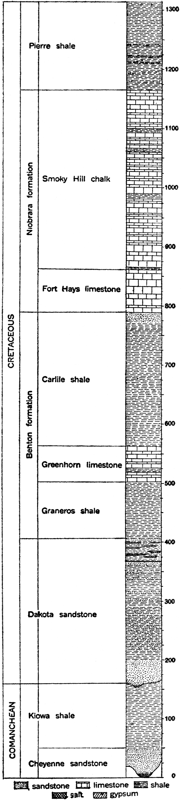
Figure 12—Generalized section of the Comanchean and Cretaceous systems in Kansas.
The total thickness of the Comanchean beds as observed in southwestern Kansas is not, then, more than 300 feet, and throughout the greater portion of its extent the division has an average thickness of less than 200 feet. It is probable that within a few miles to the north these beds pinch out entirely.
Careful studies made by Cragin, Hill, and Proaser-P indicate that the Comanchean beds of Kansas should be regarded as the attenuated equivalent of the uppermost or Washita division of the Texas Comanchean. [Note: Cragin, F. W.; On the Cheyenne Sandstone and the Neocomian Shales of Kansas: Am. Geologist, vol. 6, p. 233-238, voL 7, pp. 23, 33, 1890. Further Notes on the Cheyenne Sandstone and Neocomian Shales; Am. Geologist, vol. 7, pp. 179-181, 1891. Descriptions of the Invertebrate Fossils from the Comanche Series in Texas, Kansas and Indian Territory: Colorado Coll. Studies, vol. 5, pp. 49, 68., 1894. A Study of the Belvidere Beds (Kansas): Am. Geologist, vol. 16, pp. 357-385, 1895. Hill, Robert T.; On the Outlying Areas of the Comanche Series in Kansas, Oklahoma and New Mexico: Am. Jour. Sci., 4, vol. 1, pp. 205,234, 1895. Prosser, Charles S.; Comanche Series of Kansas: Kan. Univ. Geol. Survey, vol, 2, pp. 96, 181, 1897.]
Cheyenne Sandstone
The Cheyenne sandstone is the lower, sandy division of the Comanchean rocks in southwestern Kansas (fig. 12). It is found chiefly in the eastern part of the Comanchean area, being undeveloped for the greater part, in Clark and Meade counties, where the Kiowa shale rests directly on the Permian red beds. The Cheyenne formation is in the main a rather coarse- grained, friable sandstone, yellowish gray to whitish in color, but in many exposures spotted and striped with colors such as purple, crimson or brown. In places it is conspicuously crossbedded. Some layers in the formation are more firmly cemented than associated ones and stand out prominently on weathered exposures. The outcrop is characteristically rugged and carved by erosion into various forms. Fossil wood and imprints of leaves resembling leaves from the Dakota sandstone are found at different localities in the Cheyenne. The maximum observed thickness of the formation is about 70 feet (Prosser, 1987b, p. 112), but its average ranges from 40 to 55 feet.
Kiowa Shale
The upper portion of the Kansas Comanchean consists of shaly material. The rocks composing this, the Kiowa shale, are as widely distributed in the state as the Comanchean, and are found in places overlying the Cheyenne sandstone, elsewhere resting directly on the Permian red beds. Over a large area there is found at the base of the formation a very calcareous zone filled with invertebrate fossils. This called by Cragin (1895, p. 368) the Champion shell bed, is essentially a limestone member and is regarded as the probable equivalent of the Comanche Peak limestone of Texas (F. W. Cragin, letter to Charles S. Prosser, 1897b, p. 114).
Above the fossiliferous calcareous zone is black, laminated, argillaceous shale, which gradually changes upward to bluish and grayish, slightly arenaceous shale. The upper part of the formation consists of fossiliferous yellowish-gray shale with thin layers of yellowish or pinkish limestone. The maximum thickness of the Kiowa shale is 150 feet, measured on Bluff creek, in Clark County, the average being about 125, or 130 feet (F. W. Cragin, letter to Charles S. Prosser, 1897b, p. 115).
Cretaceous System
General Description
Distribution
Occupying an area of nearly 25,000 square miles in north central Kansas, and appearing at the surface in smaller tracts at various places in the western part of the state, are strata belonging to the Cretaceous system. The eastern boundary of the Cretaceous outcrop is a very irregular line trending southwest from Washington County to Reno County. Important outliers occur in Saline, Dickinson, Marion and McPherson counties. To the south and west the Cretaceous is concealed by a widespread mantle of Tertiary sands, gravels and other deposits. Along many of the streams, however, especially the main lines of drainage, the Tertiary cover has been removed by erosion, exposing the Cretaceous in long, narrow arms. Along Smoky Hill river, for example, Cretaceous strata are exposed to the west beyond the Colorado state line. The small areas of Cretaceous outcrops surrounded by Tertiary, which occur both to the north and south of the Smoky Hill, are found mainly where streams have cut through the overlying Tertiary.
Thickness
The maximum thickness of the Cretaceous rocks in Kansas is probably not more than 1,300 feet, but since the uppermost formation, the Pierre shale, is restricted to the northwestern portion of the state, it is certain that the thickness of the Cretaceous in the main area of its outcrop is very much less. In general, greater thicknesses are to be measured proceeding to the west, where successively higher divisions of the system are encountered. The thickness of the individual formations appears to remain fairly constant, so that measurements made at the outcrop closely approximate the record of thickness obtained from well-logs a hundred or more miles distant. The average thickness of the Cretaceous formations in Kansas is shown on the accompanying generalized section (fig. 12).
Lithologic character
The Cretaceous system is composed of clayey and sandy shale, chalky limestone and sandstone, named in the order of their quantitative importance in the section.
The shales are, for the most part, rather dark in color, ranging from dark blue-gray or brown to black. The "somber" color of some of the Cretaceous shale divisions is a characteristic feature throughout the entire Northwest. Some of the shale beds are bituminous and contain thin beds of lignite. Light-gray to almost white shales are well developed locally.
The limestone strata of the Cretaceous are in most cases characterized by their peculiar chalky texture. In some localities the rock is a pure chalk, white to light gray in color, and composed almost wholly of the microscopic remains of lime-shelled Foraminifera. From the purer varieties there is every gradation to chalky shale or calcareous sandstone. Some of the limestone is hard and resistant, but in general it is much too soft for use in building. Colors observed include light blue, lavender, yellow, buff, and light red. In a few places the chalky limestone beds contain concretions of flinty chert. A variety of other concretions are also observed.
The sandstone of the Cretaceous in Kansas belongs chiefly to the basal division, the Dakota. The Dakota sandstone is a coarse-grained, rather loosely cemented, massively bedded formation, gray to light or dark brown in color. As observed in many exposures it is very much cross-bedded. The chief cementing material is calcium carbonate, but iron oxide is also abundant, the content of iron being so great at some weathered exposures that the color is changed to a very dark brown and the weight of the rock is perceptibly increased. Where the rock is firmly cemented, it is very hard and resistant, but other portions of the formation are soft and crumbling. As a rule, the rock is very porous and presents most favorable conditions for the storage of underground water. Sandy beds, which occur higher in the system, as in the Carlile shale, are finer in their average texture and lighter colored than the Dakota.
Effect of topography
The topography of the Cretaceous area is essentially similar in many respects to that of the Pennsylvanian and Permian area farther east. The most prominent topographic features of eastern Kansas are the series of north-south escarpments formed by hard limestone members which alternate with soft, easily eroded shale members. In the area of Cretaceous outcrop there are also horizons which offer relatively great resistance to agencies of erosion and, as in the Pennsylvanian area, more or less prominent escarpments are formed. However, the Cretaceous escarpments are in general less persistent and clearly defined. The divides between streams are rather characteristically broken up into buttes and isolated hills. The east margin of the Dakota sandstone is especially marked by rough craggy buttes. Shales areas in the Cretaceous belt, especially that of the Pierre shale, are marked in some districts by more or less numerous symmetrical "tepee buttes," hill of shale capped by large concretions or other resistant portions of the rocks.
Structure
As shown by Logan (1897), and as indicated in the structure-contour map (part IV), the general dip of the Cretaceous formations in Kansas is to the northeast. The dip is very gentle, amounting to an average of about 5 to 7 feet per mile, and appears to be constant for considerable distances. As determined by Darton (1905), chiefly from well records, the Cretaceous of northwestern Kansas dips to the north and northwest, a broad, gentle anticline with a north-and-south-trending crest being found close to the line between Decatur and Norton counties. Similarly a slight anticlinal bulge is indicated in Ford and Hodgeman counties. A more clearly defined structural feature is found near the western border of the state, south and southwest of Coolidge, Hamilton County.
Faunal character
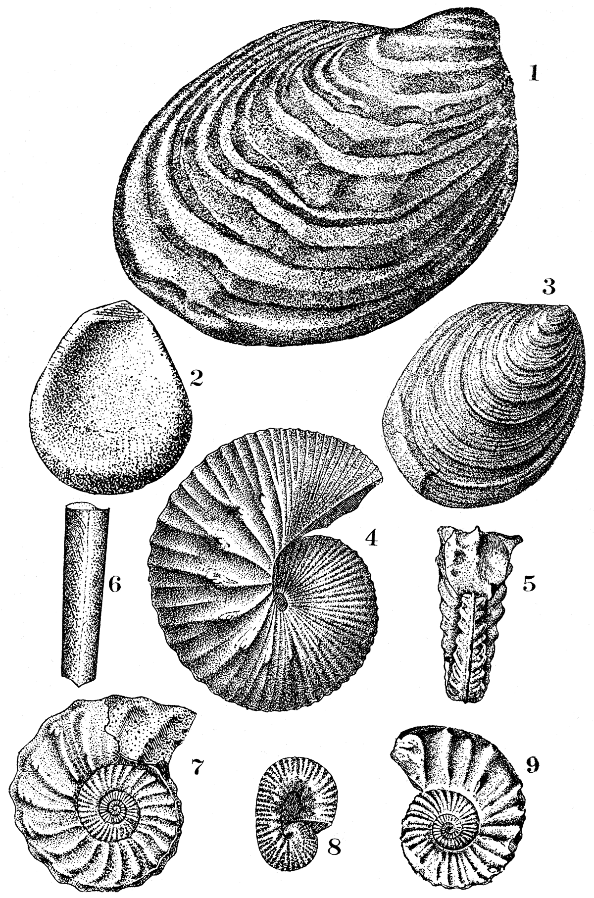
The fossils of the Cretaceous are so very different from those of other parts of the state that they may be distinguished with the greatest ease. Mollusks make up more than ninety per cent of all the faunas, large and small pelecypods being the most abundant, and the coiled, rather highly ornamented cephalopods being the next most common. Oysters are extremely, common in some beds, locally making deposits which are composed almost wholly of their shells. A number of varieties of Inoceramus are found, and as a whole they are probably more widespread and more abundant in the Cretaceous rocks of Kansas than any other fossil. Examples of common invertebrate fossils from the Cretaceous of Kansas are illustrated in plate VIII.
Plate IX—Typical fossils from the Cretaceous. Pelecypods: Inoceramus gilberti, a robust, coarsely concentric wrinkled shell. 1; Inoceramus labiatus, one of the commonest fossils in the Cretaceous of Kansas, 3; Ostrea congesta, an early oyster which lived in very large numbers in the Cretaceous seas of Kansas, view of interior of shell, 2. Cephalopods: Belemnitella baculus, a small, straight shell representing an earty squid, broken part of II specimen, 6; Scaphites vermiformis, a closely coiled, ribbed ammonite of the Benton, 4; Prionotropis woolgari, 7; Prionotropis hyatti, side view. 9, front view 5; Scaphites larvaeformis, 8. [Also available as a larger Adobe Acrobat version, 3.3 MB.]
The Cretaceous rocks of Kansas are famous all over the world on account of the remarkable vertebrate fossils which have been found in them, and which, largely through the studies of Dr. S. W. Williston, while a member of the State Geological Survey, have been made known. Among the most noteworthy of these are the large marine reptiles, the mosasaurs, plesiosaurs, and ichthyosaurs; the flying reptiles or pterosaurs; and some extremely interesting primitive toothed birds. Many of these fossils, both vertebrate and invertebrate, are at present at the State University of Kansas at Lawrence.
Subdivisions
On the basis of lithologic character and fossils, the strata of the Cretaceous have been divided into a number of formations and members. The classification of the system as developed in Kansas agrees closely with that generally adopted in the Great Plains province. The names used in this report are those which appear to belong most appropriately with the subdivisions in Kansas and which accord most closely with established rules of priority.
| Subdivision of the Cretaceous System in Kansas | |
|---|---|
| Formation | Member |
| Pierre shale | Undifferentiated |
| Niobrara | Smoky Hill chalk Fort Hays limestone |
| Benton | Carlile shale Greenhorn limestone Graneros shale |
| Dakota sandstone | Undifferentiated |
Plate X—Dakota sandstone bluffs in eastern Ellsworth county, about six miles west of Brookville.
Dakota Sandstone
[Named from Dakota City, Neb. (Meek and Hayden, 1862, p. 410, 420).]
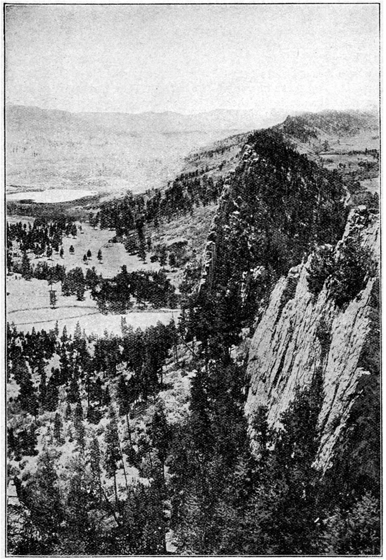
The Dakota sandstone appears at the surface in a rather narrpw but extremely irregular zone, which extends from Washington County south and southwest to Arkansas river in Rice and Barton counties, and up the Arkansas to Ford County, where it disappears beneath the Tertiary deposits. The formation reappears in a number of places along Cimarron river and its tributaries in the extreme southwestern corner of the state. To the northwest the Dakota sandstone passes beneath the higher formations of the Cretaceous, extending, deeply buried, far beyond the state boundaries. It is sharply upturned with other sedimentary beds on the east flank of the Rocky Mountainain Colorado. (Plates II and XI.) In northwestern Kansas it probably lies more than 2,000 feet below the surface. In the northern counties the Dakota rests on the dark shales Of the Wellington formation, to the south on red strata of the Cimarron group. The equivalent of the Dakota in southwestern Kansas is found overlying the eroded Comanchean deposits.
While the Dakota is chiefly a sandstone formation, there are important associated shale deposits at this horizon in Kansas. The shale, although considerable in extent, is so variable in its relation to the sandstone that stratigraphic division is not possible. As defined by Logan (1897, p. 207-209) from extensive observations along the outcrop of the Dakota, there are two main divisions of the formation in central Kansas—a lower portion, 150 feet or more thick, consisting of massive sandstone alternating with variously colored shale; and an upper portion, 35 to 50 feet thick, containing lignite and more or less abundant salt and gypsum. The total thickness of the Dakota ranges from 200 to more than 300 feet (Darton, 1905, p. 152).
Plate XI—Wall of Dakota sandstone west of Trinidad, Colo. Outcropping edge of sandstone upturned on east side of Rocky Mountain uplift.
Benton Formation
[Named from Fort Benton, Mont. (Meek and Hayden, 1862, p. 419, 421).]
The Benton formation consists of shale with intercalated limestones and sandstones. Its outcrop is a wide belt of rather gently undulating country extending diagonally across the state from Republic and Washington counties at the northeast to Ford, Hodgeman and Finney counties in the southwest. Here the Benton disappears beneath the Tertiary, but it reappears along the valley of Arkansas river in Kearny and Hamilton counties. The thickness of the formation is somewhat variable, but it averages about 400 feet.
Three main stratigraphic subdivisions are included in the Benton formation of Kansas from the base upward, respectively, the Graneros shale member, the Greenhorn limestone member, and the Carlile shale member.
Generos shale member
[Named from Graneros, Pueblo County; Colorado (Gilbert, 1896, p. 564).]
The basal portion of the Benton is a dark clay shale varying in thickness from 20 to 30 feet (Logan, 1897, p. 216) to nearly 200 feet (Darton, 1915, p. 44). In central Kansas this member, which from exposures in Colorado has been called the Graneros shale, is rather bituminous, hard and slaty, and on weathering breaks into thin flakes. Here it is not very thick, but in the valley of Arkansas river toward the western border of the state it is a very important division.
Greenhorn limestone member
[Named from Greenhorn, Pueblo County, Colorado (Gilbert, 1896, p. 564).]
The middle portion of the Benton formation, throughout Kansas and eastern Colorado, is composed of calcareous beds, including limy shale, soft, chalky limestone, and thin beds of hard, resistant limestone. This division, 40 to 60 feet in thickness, is termed the Greenhorn limestone. The basal part of the member, about 15 feet thick ("Lincoln marble" of Logan, 1897, p. 216), is made up of bluish-gray, hard, flinty but easily weathering limestone, in beds less than 6 inches thick, alternating with shale. About 16 feet of white or light-cream colored, fine-grained, thin-bedded limestone ("Flagstone" horizon) (Logan, 1897, p. 216) follows, and is overlain in turn by 40 feet of limy shales and thin beds of limestone filled with impressions of the fossil shell Inoceramus labiatus ("Inoceramus" horizon) (Logan, 1897, p. 216). The top of the Greenhorn member is marked by a stratum of limestone about 9 inches thick which breaks characteristically into long, angular pieces somewhat like fence posts ("Fence post" horizon) (Logan, 1897, p. 216).
Carlile shale member
[Named from Carlile, Pueblo County, Colorado (Gilbert, 1896, p. 565).]
The Uppermost portion of the Benton formation in Kansas consists almost entirely of shale, which from Colorado exposures has, been called the Carlile shale member. The lower portion of the shale, about 100 to 150 feet in thickness, is a soft clay shale, dark bluish gray in color. It contains occasional thin beds of limestone and is very fossiliferous, containing especially enormous numbers of fossil oysters ("Ostrea shales") (Logan, 1897, p. 220, 221). The upper part of the Carlile member is an unfossiliferous, loose-textured blue-gray shale, characterized by the occurrence in its upper portion of numerous concretions. The concretions are lens-shaped, and vary in size up to 4 or 5 feet in diameter. They are dark colored, and are solid carbonate of lime or hollow geodes lined with calcite crystals.
Niobrara Formation
[Named from Niobrara river, Nebraska (Meek and Hayden, 1862, p. 419, 422).]
The Niobrara formation, comprising the main calcareous portion of the Cretaceous system in Kansas, underlies the entire northwestern part of the state. Its outcrop is a wide area trending southwest from Jewell County to Finney County, marked at its eastern margin by a series of slopes which rise above the rolling topography of the Benton formation. To the west the Niobrara is thickly covered by deposits of Tertiary age, but along the larger streams, notably Smoky Hill river, the Tertiary has been cut away, making extensive exposures of the subjacent Niobrara. The thickness of the Niobrara formation ranges from about 350 feet (Logan, 1897, p. 220, 221) to 650 feet (Darton, 1905, p. 155), the average being somewhat nearer the lower figure. On lithologic as well as faunal grounds, a division of the Niobrara formation is made in Kansas.
Fort Hays limestone member
[Named from the former Fort Hays, Ellis County, Kansas (Mudge, 1876, p. 218-221).]
The lower portion of the Niobrara, having an average thickness of 50 feet, is the Fort Hays limestone member. The limestone is a soft, massive, light-colored rock, sufficiently resistant to erosion to weather out in bluffs of some prominence. In well borings, it is distinguished in most cases from associated members by its greater hardness. The outcrop of the Fort Hays limestone member extends along the margin of the Niobrara area from Jewell County to Finney County and up Smoky Hill river into Gove County. It is also observed in central Hamilton County north of Coolidge and at other points north of Arkansas river.
Smoky Hill chalk member
[Named from Smoky Hill river, Kansas (Cragin, 1896b, p. 51).]
The upper division of the Niobrara, termed the Smoky Hill chalk member, comprises much the thicker portion of the formation, having a total thickness ranging from 300 to 350 feet. In an unweathered condition the chalk is a massive, light bluish-gray, clayey rock, but on weathering the color changes to yellow or buff, or in some cases light red on account of the oxidation of iron contained in the deposit. Surface waters serve to leach out the oxidized iron and other coloring matter in many places, leaving the chalk rock bleached and white. In well borings the member appears in most cases as a pale-blue chalky clay, which is only slightly sticky when wet. Some rather pure chalk is found locally in the Smoky Hill member, as near Norton. The best exposures of the chalk are found in the valley of Smoky Hill river, where prominent buttes and castellated cliffs mark the outcrop.
Pierre Shale
[Named from Fort Pierre, Now Pierre, S. Dak (Meek and Hayden, 1862, p. 419, 424).]
The northwest counties of Kansas are underlain by the Pierre shale, the uppermost division of the Cretaceous in this region. The Pierre is covered by deposits of Tertiary for the greatest part, but outcrops appear in Cheyenne County, along Beaver and Sappa creeks in Rawlins and Decatur counties; on Prairie Dog creek, southwest of Norton County, and over a large area on Smoky Hill river and tributaries in Wallace and Logan counties. The shale is somber, dark bluish-gray in color, but weathers to a brownish tint. The formation is soft and clayey, yielding readily to agencies of erosion. Some beds contain rather numerous lens-shaped concretions which contain distinctive marine fossils. The maximum thickness of the Pierre shale in Kansas is not more than 200 feet (Logan, 1897, p. 221).
Tertiary and Later Deposits
The greatest part of western Kansas, comprising an area thousands of square miles in extent, is covered by a mantle of sand, gravel and limy clay which appears to have been deposited in late Tertiary time. This widespread. Tertiary deposit forms the capping of the so-called high plains, and extends for great distances over eastern Colorado and western Kansas and Nebraska. The name Ogalalla formation, from a locality in southwestern Nebraska, has been adopted for this portion of the Tertiary (Darton, 1898, p. 784).
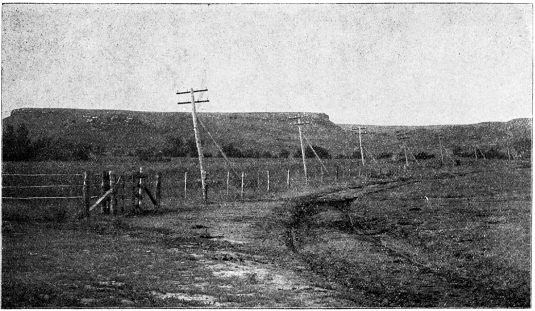
Plate XII—The Great Plains of western Kansas, smooth and almost level, sloping gently upward toward the west. In country like this there is no surface evidence whatever of underground structure.

Ogalalla Formation
The Ogalalla formation, as indicated by present field investigations, occupies all of the high plains (plate XII) of western Kansas. Its eastern boundary is a very irregular line trending southwestward from Jewell County to Finney County, thence eastward to Reno County, where it turns again to the southwest into Clark and Meade counties. The formation extends farthest east along the divides between the main streams. The larger rivers have cut through the Tertiary and carried away the sand and gravel from large areas. In some instances, notably the valley of Smoky Hill river, the Ogalalla has been removed for long distances; but in others, as along Cimarron river and tributaries in southwestern Kansas, it has been cut away only locally (plate XXII).
The materials of the Ogalalla formation are mainly sands, gravelly sands and gravels more or less cemented by carbonate of lime into a grit rock which in many cases has the appearance of rough mortar. On account of this resemblance, the name "mortar beds" has been rather widely applied to portions of the Kansas Tertiary (Haworth, 1897a, p. 22, 25, 32, etc.; Haworth, 1897b, p. 258-260). The deposits are in general calcareous, in some cases consisting mainly of lime carbonate and containing but little sand. In places, the formation is a light colored sandy clay containing much carbonate of lime in streaks or nodules. The gravels found in the Ogalalla formation and derived by its weathering contain pebbles varying in size from 4 to 5 inches in diameter to coarse sand. They are composed of granite, syenite, porphyry, basalt and other igneous rocks and are evidently derived from areas of crystalline rocks to the west. Quartz pebbles are common. The sand is merely the finer material derived from the weathering of igneous rocks, but is largely a pure quartz sand. It exhibits various degrees of fineness, but when examined closely the grains are in almost all cases well-rounded. Accumulations of small pockets of black magnetite sand are not uncommon in many parts of the Ogalalla (Haworth, 1897b, p. 255). Clay beds are commonly white or pinkish and in some places form low steep banks or cliffs along the headwaters of streams. In a few localities, especially Nortonand Phillips counties, beds of volcanic ash a numberof feet in thickness occur. They are evidently related to similar deposits which have been found over a considerable area in Nebraska (Darton, 1898, p. 760, 761) and Oklahoma (Buttram, 1814) Volcanic ash does not constitute an important part of the Kansas Tertiary deposits.
The thickness of the Ogalalla formation in Kansas varies from practically nothing to more than 300 feet. Throughout the largest part of western Kansas it averages from 150 to 200 feet. In general the records of wells which have been drilled through the formation indicate that the greatest thicknesses are found on broad flat divides which have been little affected by erosion.
There are no well-defined stratigraphic horizons in the Kansas Tertiary which can be traced over considerable areas in an investigation of the structure of these beds. Prominent "mortar beds," which are well developed in some regions, cannot be traced with sufficient accuracy or to a sufficient distance to be of great service. Also, these distinctive portions of the Tertiary are found at the base, in the middle or at the summit of the formations in different localities. Since, however, a very large portion of the area underlain by the Ogalalla is an almost featureless plain, it is in general very difficult to determine in any satisfactory way the structural relations of the Tertiary.
Numerous remains which have been found in the Ogalalla formation in Kansas indicate that it should be referred to the Pliocene epoch of Tertiary time, and the deposits are so correlated by Darton (1905, p. 150), but it is possible that at least in part the beds are upper Miocene in age.
Quaternary Deposits
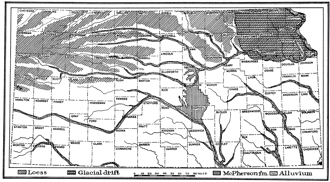
Deposits made during the Glacial epoch and in recent geologic time are found in various parts of the state. They are of importance to the petroleum geologist and producer because of their relations to the underlying consolidated strata, which must be studied carefully in any scientific exploration for oil or gas. In some cases these deposits only partially obscure the structure of the subjacent rocks, but in others they conceal it entirely. The deposits in Kansas which are referred to the Quaternary (plate XIII) include (a) glacial deposits, (b) Pleistocene river deposits; (c) loess, (d) alluvium, and (e) sand hills.
Plate XIII—Outline map showing distribution of the Quaternary deposits of Kansas.
(a) Glacial deposits
The former existence of a large glacier which advanced from the north and covered a large area in the northeastern portion of the-state is evidenced by widespread deposits of glacial drift, bowlders and other glacial materials which entirely cover the region north of Kansas river and east of Washington and Riley counties (plate XIII). The glacial drift is a heterogeneous mixture of clay, sand, pebbles, and bowlders which is found on the hilltops as well as in the valleys. The drift was deposited beneath and at the margin of the "Kansas ice sheet," one of the earliest of the continental glaciers which during the Pleistocene covered enormous areas in the United States. The drift is very much weathered and thoroughly oxidized, so that the color due to the iron oxide content is in most cases a rich brown or red and the pebbles and bowlders are decayed and soft. Sufficient time has elapsed since the glaciation of northeastern Kansas to permit considerable stream erosion. Lakes and swamps which are so numerous in recently glaciated districts are therefore absent, and the general appearance of the country resembles somewhat non-glaciated portions of the state. In some places, the drift and other deposits made by the glacier have been removed by erosion, exposing the underlying hard rook strata, but for the greater part, the mantle of glacial material effectually covers the underlying bed rock and obscures its structure. Lake deposits of glacial origin have been identified by Professor Todd at various points along the margin of the Kansas glacier. The thickness of the glacial drift is on the average not greater than 6 to 10 feet, and in many places it is practically absent, but locally, as shown by well-borings, there are accumulations of more than 60 feet (Personal communication from Prof. J. E. Todd.).
(b) Pleistocene river deposits
During the Pleistocene, or Glacial period, considerable deposits of sand, sandy clay, and alluvium were made in various stream valleys of the state. In some cases the material deposited may have been derived from the continental glacier to the north, but in large part the deposits were evidently obtained by normal erosion processes from the drainage basins of the streams themselves. Extensive deposits of this sort are found along the course of Arkansas river, Kansas river, and tributaries. One of the most interesting of the river deposits of Pleistocene time in Kansas is found in McPherson, Marion, Harvey and Reno counties (plate XIII). This deposit, which has been called the McPherson formation, is found in a broad channel, carved in the upper Permian shales and the Dakota sandstone, and extending from Smoky Hill river at the north to Arkansas river in Sedgwick County. [Named from McPherson, McPherson County, Kansas (Haworth and Beede, 1897, p. 287-296).] The area covered comprises practically the entire eastern half of McPherson County south of a line drawn from Lindsborg to Canton, all of Harvey County west of Newton and most of eastern Reno County. The material composing the deposit consists of irregular layers of sand, clay and gravel, cemented loosely by carbonate of lime. The sand and gravel contain an abundance of water, and supply the water plants of neighboring cities. The thickness of the formation varies from a few feet to more than 100 feet.
(c) Loess
Covering a wide area of the High Plains between the valleys of northern and northwestern Kansas is a smooth-surfaced, thick mantle of loess (plate XIII). According to Darton (1905), the border of the loess-covered area trends eastward from Greeley County to Ellis County, thence northward to Osborne County and northeastward to Republic and Washington counties. There are also thick deposits of loess throughout northeastern Kansas in the district covered by the glacial drift. There are no sharp boundaries to the region of loess deposits because of the presence of the loess only on the uneroded uplands. In the west in few cases does it exceed a thickness of 30 to 40 feet, and on the average it is very much less, but in the northeastern counties of the state the thickness is in general much greater and in some places near Missouri river the loess is more than 100 feet thick.
(d) Alluvium
There are many wide valleys in Kansas which are filled to various depths with deposits of alluvial material brought down by the streams. The largest and most extensive of these river deposits is that along the Arkansas river valley, which has a width of 6 to 10 miles and crosses a considerable part of the state. Other large streams, such as Kansas river and its tributaries to the west, Republican, Solomon, Saline, and Smoky Hill rivers, have wide flood-plains composed of river-made alluvium. All the river and creek valleys contain more or less alluvial material of relatively recent origin, and most of the lower slopes of hills are covered by talus and slope-wash derived from recent weathering. The deposits, which are mainly sands and loams intermixed locally with gravel, are important to the petroleum producer because of their widespread covering of rock outcrops. An excellent example is found in the Walnut river valley in southern Butler County. Some of the most productive wells and valuable leases in this district are located on the wide river bottom where there are no rock exposures and practically no indication from surface evidence of the anticlinal structure of the rocks underground which controls the accumulation of the oil.
(e) Sand dunes
A wide area in central Kansas, chiefly on the south side of Arkansas river, from Ford to Reno counties, is occupied by wind-blown sand. The sand constitutes hills and ridges of moderate height, with iregular basins and flats intervening. The sand has been derived chiefly from the alluvial flats along Arkansas river, being blown out by the winds, which are prevailingly from the northwest. Indirectly, much of the sand comes from the weathering of the Dakota sandstone and Tertiary deposits in the region. The dune sand effectually covers the bed rock and makes impossible any determination of the rock structure from surface evidence. The area occupied, by the sand, therefore, can be prospected only by "wild-cat" methods.
Prev Page--Permian || Next Page--References
Kansas Geological Survey, Geology
Placed on web Sept. 15, 2017; originally published 1920.
Comments to webadmin@kgs.ku.edu
The URL for this page is http://www.kgs.ku.edu/Publications/Bulletins/6_2/05_coman.html