Prev Page--Contents || Next Page--Nomenclature
Introduction
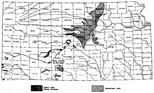
The Belvidere area described in this report comprises about 100 square miles in southeastern Kiowa County, Kansas (Fig. 1). It is named the Belvidere area for a small unincorporated town that serves as headquarters and cattle-shipping point for the surrounding ranches.
Fig. 1--Area covered by this report and the outcrop areas of the Comanchean series (Cheyenne sandstone and Kiowa shale) and lowermost Gulfian series (Dakota formation) in Kansas. A larger version is available.
The Belvidere area is in the Plains Border section of the Great Plains physiographic province. At one time the surface of this area was continuous with that of the upland plains on the west and north, but Medicine Lodge River and its tributaries have since cut below the Quaternary and Tertiary deposits that underlie the uplands and exposed a large area of Cretaceous and Permian rocks. Rocks belonging to the Comanchean series are especially well developed in this area and many excellent outcrops are found. Overlying the Comanchean rocks in the upper part of Medicine Lodge Valley are younger Cretaceous sediments belonging to the Dakota formation--the lowermost formation of the Gulfian series in Kansas.
The stratigraphy of the Comanchean and lowermost Gulfian rocks in Kansas and adjacent areas has been studied by numerous geologists for many years. Although the character of these sediments is fairly well known, their relationship to one another and hence their proper classification have been a matter of controversy. The Belvidere area is the type area for the lower part (Comanchean series) of these Cretaceous rocks as developed in Kansas, inasmuch as the type localities for 17 group, formation, and member names are located within this area. Only two of the 17 names have come into general use, however. These are the Cheyenne sandstone and the Kiowa shale, which together comprise all of the Comanchean series of Kansas.
The chief purpose of this report is to describe the classification, lithology, distribution, and thickness of the Comanchean and lowermost Gulfian beds as they are developed in the southern Kansas area. The field work on which the report is based was done during the summer of 1941 as part of an investigation of the geology and ground-water resources of Kiowa County made by the State and Federal Geological Surveys in cooperation with the Division of Water Resources of the Kansas State Board of Agriculture and the Division of Sanitation of the Kansas State Board of Health. The results of this county investigation are reported in a separate bulletin of the State Geological Survey of Kansas (Latta, 1947). As part of the county investigation numerous geologic sections were measured, and 18 test holes were drilled in Kiowa County. The log of one of the test holes and nine of the measured sections are given in this report.
Acknowledgments--John C. Frye of the State Geological Survey of Kansas and Claude W. Hibbard, curator of vertebrate paleontology of the Dyche Museum of Natural History, University of Kansas, spent several days in the field with me studying the Cretaceous rocks of Kiowa County and adjacent areas. Their aid in locating and measuring geologic sections was invaluable. Test hole 1 was drilled by Ellis D. Gordon, Perry McNally, and Lawrence Buck, using a portable hydraulic-rotary drilling rig owned by the State Geological Survey.
The manuscript for this report has been critically reviewed by O. E. Meinzer, S. W. Lohman, and J. B. Reeside, Jr. of the Federal Geological Survey, and, R. C. Moore of the State Geological Survey. The manuscript was edited by Betty Hagerman and the illustrations were drafted by Woodrow Wilson and Murl Rush.
Prev Page--Contents || Next Page--Nomenclature
Kansas Geological Survey, Geology
Placed on web Aug. 28, 2007; originally published December 1946.
Comments to webadmin@kgs.ku.edu
The URL for this page is http://www.kgs.ku.edu/Publications/Bulletins/64_6/02_intro.html
