![]()
Prev Page--Petrography || Next Page--Conclusions
Characteristics of Pliocene and Pleistocene Volcanic Ash
Stratigraphy
The oldest volcanic ash studied by us is Pliocene in age and occurs low within the Ogallala formation of Norton County, Kansas (Pl. 1B). Exposures of Ogallala along the south bluffs of Prairie Dog Creek were studied by M. K. Elias and John C. Frye during the summer of 1945. A maximum of 6.5 feet of ash occurs in this area and its characteristics are shown by sample no. 1, Table 1 (Pl. 1C). The ash occurs at the top of Elias' (1942) Krynitzkia coroniformis zone and below his Biorbia zone, as do all but one of the Ogallala volcanic ash localities studied from Kansas. A stratigraphic section measured south of Almena, Kansas, is given below.
Plate1B--Exposure of Ogallala showing volcanic ash in place below beds from which Biorbia fossilia was collected, NW NE sec. 36, T. 2 S., R. 25 W., Norton County, Kansas (samples 26-29).
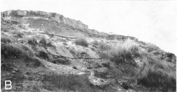
Plate1C--Cemented upper part of volcanic ash bed exposed in measured section near Almena, Norton County, Kansas. Sample no. 1 collected about 100 yards north in small abandoned pit.
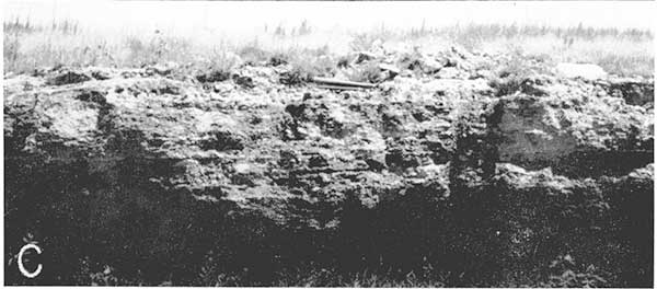
Table 1--Location, stratigraphic position, and petrographic characteristics of volcanic ash samples.
| Sample No. | Type of sample1 |
Location | Stratigraphic position |
Color2 (<.062 mm) |
Dominant refractive index |
Remarks |
|---|---|---|---|---|---|---|
| 1 | Channel, 2.5' from pit | SW NW sec. 16, T. 2 S., R. 21 W., Norton County, Kansas | Pliocene. [Ogallala fm., above Krynitzkia and below Biorbia.] | 23'''''f | 1.500-1.502 (?) | Shard outlines anisotropic. Small calcite inclusions in most particles, which are otherwise clear. |
| 2 | Spot, 14' above no. 7 | NW SW sec. 23, T. 2 S., R. 22 W., Norton County, Kansas | Pliocene. [Ogallala fm.; Krynitzkia collected from the ash.] | NGf (Neutral gray) |
1.500-1.502 | Most shards clear. Trace quartz sand. Commercial pit of Wyandotte Chemicals Corporation. |
| 3 | Spot, 10' above no. 7 | NW SW sec. 23, T. 2 S., R. 22 W., Norton County, Kansas | Pliocene. [Ogallala fm.; Krynitzkia collected from the ash.] | NGf (Neutral gray) |
1.500-1.502 | Most shards clear. Trace quartz sand. Commercial pit of Wyandotte Chemicals Corporation. |
| 4 | Spot, 7.5' above no. 7 | NW SW sec. 23, T. 2 S., R. 22 W., Norton County, Kansas | Pliocene. [Ogallala fm.; Krynitzkia collected from the ash.] | NGf (Neutral gray) |
1.500-1.502 | Most shards clear. Trace quartz sand. Commercial pit of Wyandotte Chemicals Corporation. |
| 5 | Spot, 5' above no. 7 | NW SW sec. 23, T. 2 S., R. 22 W., Norton County, Kansas | Pliocene. [Ogallala fm.; Krynitzkia collected from the ash.] | NGf (Neutral gray) |
1.500-1.502 | Most shards clear. Trace quartz sand. Commercial pit of Wyandotte Chemicals Corporation. |
| 6 | Spot, 2.5' above no. 7 | NW SW sec. 23, T. 2 S., R. 22 W., Norton County, Kansas | Pliocene. [Ogallala fm.; Krynitzkia collected from the ash.] | NGf (Neutral gray) |
1.500-1.502 | Most shards clear. Trace quartz sand. Commercial pit of Wyandotte Chemicals Corporation. |
| 7 | Spot, 1-3' above base | NW SW sec. 23, T. 2 S., R. 22 W., Norton County, Kansas | Pliocene. [Ogallala fm.; Krynitzkia collected from the ash.] | NGf (Neutral gray) |
1.500-1.502 | Most shards clear. Trace quartz sand. Commercial pit of Wyandotte Chemicals Corporation. |
| 8 | Channel, 6'-12' from bottom | NW SW sec. 23, T. 2 S., R. 22 W., Norton County, Kansas | Pliocene. [Ogallala fm.; Krynitzkia collected from the ash.] | NGf (Neutral gray) |
1.500-1.502 | Most shards clear. Trace quartz sand. Commercial pit of Wyandotte Chemicals Corporation. |
| 9 | Channel, bottom 6' | NW SW sec. 23, T. 2 S., R. 22 W., Norton County, Kansas | Pliocene. [Ogallala fm.; Krynitzkia collected from the ash.] | NGf (Neutral gray) |
1.500-1.502 | Most shards clear. Trace quartz sand. Commercial pit of Wyandotte Chemicals Corporation. |
| 10 | Refined product | NW SW sec. 23, T. 2 S., R. 22 W., Norton County, Kansas | Pliocene. [Ogallala fm.; Krynitzkia collected from the ash.] | NGf (Neutral gray) |
1.500-1.502 | Most shards clear. Trace quartz sand. Commercial pit of Wyandotte Chemicals Corporation. |
| 11 | Spot, 3' above base 25 yards N. of road | SW SE sec. 2, T. 3 S., R. 25 W., Norton County, Kansas | Pliocene [Ogallala fm.] | 2'''''g | 1.500-1.502 | Altered. Few vesicles. Much calcite. |
| 12 | Spot, 1' above base | SW SE sec. 2, T. 3 S., R. 25 W., Norton County, Kansas | Pliocene [Ogallala fm.] | 23'''''f | 1.500-1.502 | Most shards clear. |
| 13 | Spot, bottom 1" | SW SE sec. 2, T. 3 S., R. 25 W., Norton County, Kansas | Pliocene [Ogallala fm.] | 18''''b | 1.500-1.502 | Several vesicles, some calcite. Many insects, giving brown color. |
| 14 | Channel, 4'-6' from base, 150 yds. N. of road | SW SE sec. 2, T. 3 S., R. 25 W., Norton County, Kansas | Pliocene [Ogallala fm.] | 23'''''g | 1.500-1.502 | Altered, few vesicles. Ca. 1% quartz sand. |
| 15 | Channel, 2'-4' from bottom | SW SE sec. 2, T. 3 S., R. 25 W., Norton County, Kansas | Pliocene [Ogallala fm.] | 23'''''f | 1.500-1.502 | Altered. Few vesicles. |
| 16 | Channel, bottom 2' | SW SE sec. 2, T. 3 S., R. 25 W., Norton County, Kansas | Pliocene [Ogallala fm.] | 23'''''g | 1.500-1.502 | Most shards clear. |
| 17 | Channel, 5'-7' from bottom | NE SE sec. 27, T. 4 S., R. 23 W., Norton County, Kansas | Pliocene [Ogallala fm.] | 23'''f | 1.500-1.502 | Altered. Few vesicles. Ca. 25% quartz sand. |
| 18 | Channel, 3'-5' from bottom | NE SE sec. 27, T. 4 S., R. 23 W., Norton County, Kansas | Pliocene [Ogallala fm.] | 23'''f | 1.500-1.502 | Altered. Few vesicles. Trace quartz sand. |
| 19 | Channel, 2'-3' from bottom | NE SE sec. 27, T. 4 S., R. 23 W., Norton County, Kansas | Pliocene [Ogallala fm.] | 23'''f | 1.500-1.502 | Altered. Few vesicles. |
| 20 | Channel, 1'-2' from bottom | NE SE sec. 27, T. 4 S., R. 23 W., Norton County, Kansas | Pliocene [Ogallala fm.] | 23'''f | 1.500-1.502 | Altered. Few vesicles. |
| 21 | Channel, bottom 1' | NE SE sec. 27, T. 4 S., R. 23 W., Norton County, Kansas | Pliocene [Ogallala fm.] | NGg | 1.500-1.502 | Altered. Few vesicles. |
| 22 | Channel, 20" to top of bed | NE sec. 2, T. 4 S., R. 24 W., Norton County, Kansas | Pliocene. Ogallala fm., immediately above Biorbia] | 19''f | (?) | Altered. Trace of quartz sand. |
| 23 | Channel, 8"-20" from bottom | NE sec. 2, T. 4 S., R. 24 W., Norton County, Kansas | Pliocene. Ogallala fm., immediately above Biorbia] | 21''''g | 1.500-1.502 | Somewhat altered. Trace of quartz sand. |
| 24 | Channel, 2"-8" from bottom | NE sec. 2, T. 4 S., R. 24 W., Norton County, Kansas | Pliocene. Ogallala fm., immediately above Biorbia] | 18'''''g | 1.500-1.502 | Most shards clear; a few altered. |
| 25 | Channel, bottom 2" | NE sec. 2, T. 4 S., R. 24 W., Norton County, Kansas | Pliocene. Ogallala fm., immediately above Biorbia] | 18'''''g | 1.500-1.502 | Most shards clear; a few altered. |
| 26 | Channel, 2'-3' from bottom | NW NE sec. 36, T. 2 S., R. 25 W., Norton County, Kansas | Pliocene [Ogallala fm., immediately below Biorbia. | 23'''''g | 1.506-1.507 | Altered. Few vesicles. Ca. 6% quartz sand. |
| 27 | Channel, 1-2' from bottom | NW NE sec. 36, T. 2 S., R. 25 W., Norton County, Kansas | Pliocene [Ogallala fm., immediately below Biorbia. | 23'''''g | 1.506-1.507 | Somewhat altered. Few vesicles. Trace quartz sand. |
| 28 | Channel, bottom 1' | NW NE sec. 36, T. 2 S., R. 25 W., Norton County, Kansas | Pliocene [Ogallala fm., immediately below Biorbia. | 23'''''g | 1.506-1.507 | Somewhat altered. Few vesicles. Trace quartz sand. |
| 29 | Spot, middle of bed | NW NE sec. 36, T. 2 S., R. 25 W., Norton County, Kansas | Pliocene [Ogallala fm., immediately below Biorbia. | 23'''''g | 1.506-1.507 | Somewhat altered. Few vesicles. Trace quartz sand. |
| 30 | Channel, lower 2' | Hemphill County Texas (Reed and Longnecker locality 20) | Pliocene. [ Ogallala fm.; Hemphill fauna collected from lower part of the ash and beds below.] | NGg | 1.495-1.497 | Altered. Few vesicles. |
| 31 | T. 33 S., R. 32 W., Seward County, Kansas | Pleistocene [Meade fm.] | 17'''f | 1.499-1.501 | Groups of elongate vesicles common. | |
| 32 | Channel, 3'-4' from top | Sec. 2, T. 31 S., R. 28 W., Meade County, Kansas | Pleistocene. [Meade fm., immediately above horizon of Cudahy fauna.] | 17'''f | 1.499-1.501 | Groups of elongate vesicles common. Commercial pit of Cudahy Packing Company. |
| 33 | Channel, 4'-6' from top | Sec. 2, T. 31 S., R. 28 W., Meade County, Kansas | Pleistocene. [Meade fm., immediately above horizon of Cudahy fauna.] | 17'''g | 1.499-1.501 | Groups of elongate vesicles common. Commercial pit of Cudahy Packing Company. |
| 34 | Channel, 6'-8' from top | Sec. 2, T. 31 S., R. 28 W., Meade County, Kansas | Pleistocene. [Meade fm., immediately above horizon of Cudahy fauna.] | 17'''g | 1.499-1.501 | Groups of elongate vesicles common. Commercial pit of Cudahy Packing Company. |
| 35 | Channel, 8'-10' from top, 7' from bottom | Sec. 2, T. 31 S., R. 28 W., Meade County, Kansas | Pleistocene. [Meade fm., immediately above horizon of Cudahy fauna.] | 17'''g | 1.499-1.501 | Groups of elongate vesicles present. |
| 36 | Spot, 3' below top, 100 yds. N. of 32-35 | Sec. 2, T. 31 S., R. 28 W., Meade County, Kansas | Pleistocene. [Meade fm., immediately above horizon of Cudahy fauna.] | 17'''f | 1.499-1.501 | Groups of elongate vesicles common. |
| 37 | Spot, 5' below top | Sec. 2, T. 31 S., R. 28 W., Meade County, Kansas | Pleistocene. [Meade fm., immediately above horizon of Cudahy fauna.] | 17'''g | 1.499-1.501 | Groups of elongate vesicles common. |
| 38 | Spot, 7' below top | Sec. 2, T. 31 S., R. 28 W., Meade County, Kansas | Pleistocene. [Meade fm., immediately above horizon of Cudahy fauna.] | 17'''g | 1.499-1.501 | Groups of elongate vesicles common. |
| 39 | Spot, 1.5' above bottom, 400' S. of 32 | Sec. 2, T. 31 S., R. 28 W., Meade County, Kansas | Pleistocene. [Meade fm., immediately above horizon of Cudahy fauna.] | White | (?) | Altered. Few vesicles noted. |
| 40 | NW sec. 31, T. 3 S., R. 15 W., Smith County, Kansas | Pleistocene | 17'''f | 1.499-1.501 | Groups of elongate vesicles common. | |
| 41 | Spot | S2 NW sec. 30, T. 18 S., R. 23 W., Ness County, Kansas | Pleistocene | 17'''f | 1.499-1.501 | Groups of elongate vesicles common. |
| 42 | Channel, 3'-4' from bottom | Cen. sec. 20, T. 18 S., R. 3 W., McPherson County, Kansas | Pleistocene [McPherson fm.] | 17'''f | (?) | Groups of elongate vesicles common. Shard outlines anisotropic. Small commercial pit. |
| 43 | Channel, 1'-3' from bottom | Cen. sec. 20, T. 18 S., R. 3 W., McPherson County, Kansas | Pleistocene [McPherson fm.] | 17'''g | 1.499-1.501 | Groups of elongate vesicles common. A few calcite inclusions. |
| 44 | Channel, bottom 1' | Cen. sec. 20, T. 18 S., R. 3 W., McPherson County, Kansas | Pleistocene [McPherson fm.] | 17'''g | 1.499-1.501 | Groups of elongate vesicles common. A few calcite inclusions. |
| 45 | NW sec. 20, T. 18 S., R. 3 W., | McPherson County, Kansas | Pleistocene [McPherson fm.] | 17'''g | 1.499-1.501 | Groups of elongate vesicles present, but rare. |
| 46 | Spot, middle of exposure | Road ditch SE sec. 16, T. 18 S., R 4 W., McPherson County, Kansas | Pleistocene. [Below Pleistocene loess and above McPherson fm.] | 18'''f | 1.499-1.502 | Groups of elongate vesicles common. |
| 47 | Channel, 2'-4' above bottom of pit | NW SW sec. 15, T. 18 S., R. 4 W., McPherson County, Kansas | Pleistocene. [McPherson fm.] | 17'''g | 1.499-1.501 | Groups of elongate vesicles common. Small commercial pit. |
| 48 | Channel, bottom 2' of pit | NW SW sec. 15, T. 18 S., R. 4 W., McPherson County, Kansas | Pleistocene. [McPherson fm.] | 17'''g | 1.499-1.501 | Groups of elongate vesicles common. Small commercial pit. |
| 49 | Spot, natural exposure 3 below 48 | NW SW sec. 15, T. 18 S., R. 4 W., McPherson County, Kansas | Pleistocene. [McPherson fm.] | 17'''g | 1.499-1.501 | Groups of elongate vesicles common. Small commercial pit. |
| 50 | Spot | SW sec. 22 T. 15 S., R. 7 W., Ellsworth County, Kansas | Pleistocene. [Pleistocene terrace deposits (McPherson fm.)] | 17'''g | 1.499-1.501 | Groups of elongate vesicles present but not common. |
| 51 | Channel, 2'-5' from bottom | Sec. 28, T. 13 S., R. 10 W., Lincoln County, Kansas | Pleistocene. [Pleistocene terrace deposits (McPherson fm.) Immediately above horizon of Cudahy fauna.] | 17'''g | 1.499-1.501 | Groups of elongate fluid inclusions common. Trace quartz sand. |
| 51 | Channel, 1-2' from bottom | Sec. 28, T. 13 S., R. 10 W., Lincoln County, Kansas | Pleistocene. [Pleistocene terrace deposits (McPherson fm.) Immediately above horizon of Cudahy fauna.] | 17'''f | 1.499-1.501 | Groups of elongate fluid inclusions present. |
| 53 | Channel, bottom 1' | Sec. 28, T. 13 S., R. 10 W., Lincoln County, Kansas | Pleistocene. [Pleistocene terrace deposits (McPherson fm.) Immediately above horizon of Cudahy fauna.] | 17'''g | 1.499-1.501 | Groups of elongate fluid inclusions present. Shards somewhat altered. |
| 54 | 3.5' composite channel. | Sec. 28, T. 13 S., R. 10 W., Lincoln County, Kansas | Pleistocene. [Pleistocene terrace deposits (McPherson fm.) Immediately above horizon of Cudahy fauna.] | 17'''g | 1.499-1.501 | Groups of elongate fluid inclusions fairly common. Some alteration. |
| 55 | Channel, 6.3' | W2 SE sec. 27, T. 13 S., R. 10 W., Lincoln County, Kansas | Pleistocene. [Pleistocene terrace deposits (McPherson fm.) Immediately above horizon of Cudahy fauna.] | 17'''g | 1.499-1.501 | Groups of elongate fluid inclusions common. Small commercial pit. |
| 56 | 1' channel from middle bed | NE NW sec. 29, T. 10 S., R. 5 W., Ottawa County, Kansas | Pleistocene. [Immediately above large molluscan fauna.] | 17'''g | 1.499-1.502 | Altered. Elongate fluid inclusions rare, but present. |
| 57 | 6' above bottom of exposure | NW sec. 34, T. 8 S., R. 2 8 W., Sheridan County, Kansas | Pleistocene. [Sanborn fm.] | 17'''g | 1.499-1.501 | Groups of elongate vesicles common. Small commercial pit. |
| 58 | 3' above bottom | NW sec. 34, T. 8 S., R. 2 8 W., Sheridan County, Kansas | Pleistocene. [Sanborn fm.] | 17'''g | 1.499-1.501 | Groups of elongate vesicles common. Small commercial pit. |
| 59 | Bottom of exposure | NW sec. 34, T. 8 S., R. 2 8 W., Sheridan County, Kansas | Pleistocene. [Sanborn fm.] | 18'''g | 1.499-1.501 | Groups of elongate vesicles common. Small commercial pit. |
| 60 | Cross-bedded lens at level of 58 | NW sec. 34, T. 8 S., R. 2 8 W., Sheridan County, Kansas | Pleistocene. [Sanborn fm.] | 17'''g | 1.499-1.501 | Groups of elongate vesicles very abundant. |
| 61 | Cen. N. line, SW sec. 33, T. 1 S., R. 9 W., Jewell County, Kansas | Pleistocene. [Sanborn fm.] | 17'''f | 1.499-1.501 | Groups of elongate vesicles very abundant. | |
| 62 | NE SE sec. 19, T. 2 N., R. 12 W., Webster County, Nebraska | Pleistocene. [Below Loveland fm. and above Upland fm.] | 21'''f | 1.500-1.502 | Greatly altered. Groups of elongate vesicles present. Much biotite. Trace quartz sand. | |
| 63 | Spot | S2 NW sec. 20, T. 8 N., R. 24 W., Frontier County, Nebraska | Pleistocene. [At base of or immediately below Loveland fm.] | 17'''f | 1.498-1.501 | Groups of elongate vesicles common. Commercial pit of LaRue-Axtell Pumice Company. |
| 64 | Spot | W2 sec. 5, T. 5 N., R. 28 ECM, Beaver County, Oklahoma | Pleistocene. [Meade fm.] | 17"'g | 1.499 (?) | Greatly altered; individual glass shards rare. Groups of elongate vesicles present. Commercial pit. |
| 1. Channel sample, spot sample, or blank space indicates that method of sampling is unknown. 2. Color notations from Ridgway (1912). |
||||||
| Section measured south of Almena, W2 sec. 16, T. 2 S., R. 21 W., Norton County, Kansas, by M. K. Elias and John C. Frye | Thickness, feet |
||
|---|---|---|---|
| Pleistocene | |||
| 22. | Silt and fine sand, buff, contains nodules of calcium carbonate | 4.+ | |
| Ogallala formation | |||
| 22. | Silt and fine sand, buff, contains nodules of calcium carbonate | 4.+ | |
| 21. | Limestone, porous, hard, light cream; contains abundant gastropod molds | 3.0 | |
| 20. | Covered. Two feet of mortar bed exposed about midway | 35.0 | |
| 19. | Sand, silty, fine to medium, loosely cemented with calcium carbonate; contains Biorbia fossilia (Berry), Berryochloa amphoralis, and Celtis willistoni (Cockerell) | 6.4 | |
| 18. | Covered. Unconsolidated silt and sand, buff, poorly exposed at a few places | 32.0 | |
| 17. | Sand, coarse to fine, and some silt; cemented with calcium carbonate | 1.0 | |
| 16. | Sand, fine to medium, buff; contains a small amount of calcium carbonate cement | 5.0 | |
| 15. | Volcanic ash, sandy at base (becomes impure to south); upper part locally cemented with calcium carbonate | 6.5 | |
| 14. | Silt and sand cemented with calcium carbonate, roughly bedded; contains Krynitzkia coroniformis Elias | 6.5 | |
| 13. | Partly covered. Calcareous clay silt, greenish gray at top; buff silt and very fine sand with calcium carbonate concretions in middle; and greenish-gray calcareous clay silt at base | 20.0 | |
| 12. | Silt, sand, and calcium carbonate | 4.0 | |
| 11. | Sandy silt, buff, locally unevenly cemented with calcium carbonate | 0.7 | |
| 10. | Silt, sand, and calcium carbonate, massive, light greenish buff | 6.9 | |
| 9. | Sand, fine to medium, pale greenish tan | 3.7 | |
| 8. | Silt, sand, and clay, calcareous, greenish brown | 3.0 | |
| 7. | Silt, clay, and sand, greenish brown | 1.8 | |
| 6. | Sand and some gravel | 3.0 | |
| 5. | Sand, clay, and silt, greenish brown | 2.5 | |
| 4. | Sand, medium, poorly sorted, uncemented, brown | 3.0 | |
| 3. | Covered | 4.0 | |
| 2. | Limestone, porous, hard, white; contains gastropod molds | 1.0 | |
| 1. | Covered to level of railroad tracks. Top of Cretaceous occurs in this interval | 13.0 | |
| 166.0 | |||
The Ogallala of Nebraska has been considered by Lugn (1939, pp. 1258-1264) as a group with the following formations, in ascending order: Valentine, Ash Hollow, Sidney, and Kimball. The fossil seed Krynitzkia coroniformis Elias is considered by Elias (1942, p. 138) to be characteristic of the lower Ash Hollow, and he considers the zone of Biorbia fossilia (Berry) to occur immediately above the Krynitzkia zone and to include the middle and upper parts of the Ash Hollow (Elias, 1942, pp. 139-145). Thus the extensive Ogallala volcanic ash of Norton County, Kansas, probably occurs within the lower part of the Ash Hollow formation of Nebraska classification and somewhat below the mid point of the Ogallala formation as used in Kansas.
Four samples of Ogallala ash, nos. 22 to 25, were collected from one locality at a stratigraphic position that may be somewhat higher in the section, as fossil seeds, identified by M. K. Elias as Biorbia fossilia (Berry), were collected from below the ash.
A sample of volcanic ash (no. 30) was collected from the Pliocene deposits of Hemphill County, Texas, from locality 20 described by Reed and Longnecker (1932, pp. 57, 58). They assigned the beds at this locality to the uppermost part of the "middle beds" of the lower Pliocene. More recently (Wood, 1941, pl. 1, p. 12) the fauna collected from these beds has been assigned to the mid-Pliocene; therefore, this ash may be as young as, if not younger than, the extensive ash deposits of Norton County, Kansas.
Volcanic ash deposits, now considered to be of Pleistocene age, have been known from southwestern Kansas for many years. In 1896 Cragin first applied a stratigraphic name, the "Pearlette ash," to the deposits in Meade County and vicinity. In 1941, Frye and Hibbard (pp. 410-419) placed the extensive ash deposits of that area in the Meade formation of Pleistocene age, and Hibbard (1944) has described vertebrate fossils, which comprise his Cudahy fauna, from several localities immediately below the extensive ash of this region. He (Hibbard, 1944, p. 718) derived the name of the Cudahy fauna from the large volcanic ash pit (samples no. 32-39) north of the city of Meade.
Volcanic ash occurs within Pleistocene terrace deposits (Frye, Leonard, and Hibbard, 1943) of central Kansas that may represent a western extension of the McPherson formation. At several localities vertebrate fossils typical of Hibbard's Cudahy fauna have been collected from immediately below the ash. A measured section from Lincoln County, Kansas, described by Frye, Leonard and Hibbard (1943, p. 39) is given below.
| Section measured in sec. 28, T. 13 S., R. 10 W., Lincoln County, Kansas | Thickness, feet |
||
|---|---|---|---|
| Quaternary | |||
| 3. | Sand, fine, thin-bedded to laminated; grades upward into massive silt and fine sand; less sandy toward top, tan to reddish buff. Caliche nodules are distributed throughout the upper half | 27.0 | |
| 2. | Volcanic ash, thin-bedded; upper part interbedded with fine sand. Upper part of interval partly covered (samples no. 51-54) | 7.0 | |
| 1. | Sand and silt, gray, grading upward into gray, sandy, silty clay. Upper 18 inches contains rich molluscan fauna. Base of section at creek level | 11.0 | |
| 45.0 | |||
Other localities of volcanic ash of known Pleistocene age occur in central and northern Kansas. In most instances the beds including these deposits have not been assigned to named stratigraphic units. At a few places in northwestern Kansas volcanic ash (samples no. 57-61 ) occurs within strata classified as the Sanborn formation of middle to upper Pleistocene age.
For comparative purposes two samples of Pleistocene ash from Nebraska were studied. According to E. C. Reed (personal communication dated December 19, 1945) the deposit near Inavale in Webster County (sample no. 62) occurs above beds classed as Upland formation and below deposits assigned to the Loveland formation, and the deposit mined by the LaRue-Axtell Pumice Company near Eustis (sample no. 63) occurs at the base of or immediately below deposits classed as Loveland formation. A sample of ash from Beaver County, Oklahoma (sample no. 64) was collected from beds of Pleistocene age that have been assigned to the Meade formation.
Sampling and Laboratory Procedure
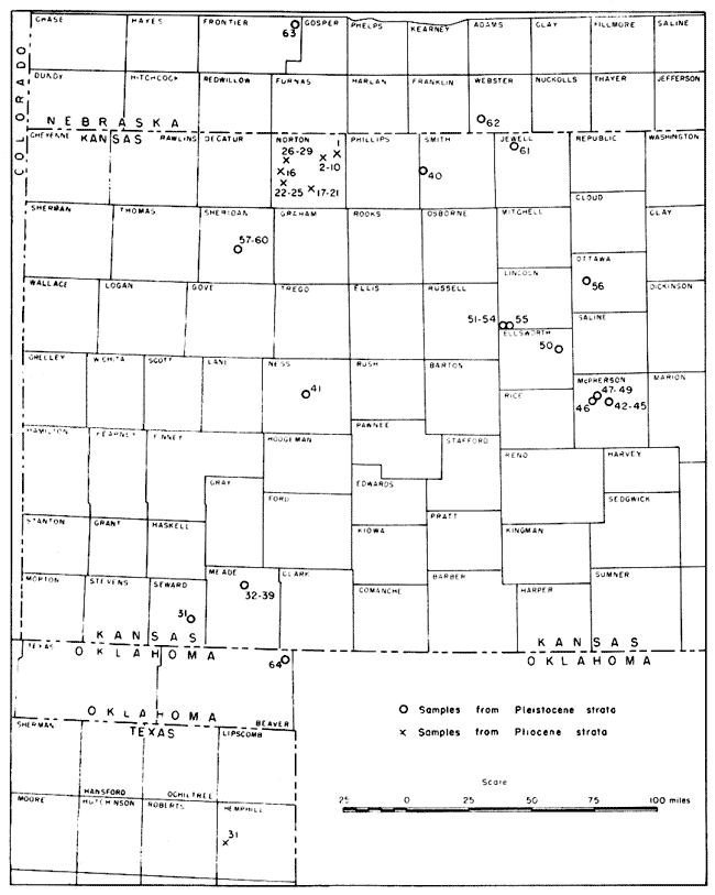
The geographic distribution of the volcanic ash deposits sampled for this study is shown in Figure 1. The Pleistocene samples are from an area extending 250 miles in a north-south direction, from northwestern Oklahoma to Nebraska, and about 150 miles east-west, from McPherson County to Seward County, Kansas. All but one of the Pliocene samples studied were collected from Norton County, Kansas. However, samples no. 30, from Hemphill County, Texas, and no. 1, from Norton County, Kansas, represent a north-south range of about 275 miles.
Figure 1--Map of western Kansas and adjacent area showing locations of ash deposits studied.
Field samples were collected wherever possible from vertical faces of commercial pits and fresh road cuts. Where natural exposures were used, care was taken to clear away slump material so that representative samples would be obtained. Where the exposures were adequate, a sequence of channel samples was taken through the entire thickness of the bed, supplemented by spot samples at several positions. At localities where this was not possible, channel samples were collected from the exposed thickness, and spot samples only were collected at a few places. Fifty-three samples from 13 localities were collected by us; 12 samples from 12 localities were obtained from the industrial minerals file of the State Geological Survey of Kansas, and furnished by Norman Plummer, S. C. Happ, R. H. Dott, and the LaRue-Axtell Pumice Company.
In the laboratory the samples were dried and split and sieve analyses were made. Each sample was studied by use of binocular and petrographic microscopes, and megascopic color comparisons of several size grades were made. The chemical composition of selected samples was determined by Frances Schloesser in the laboratory of the State Geological Survey of Kansas.
Sieve analyses were made by use of a Ro-Tap sieve shaker equipped with screens of half Wentworth grades from 0.71 mm to 0.062 mm. About 40 grams of sample was placed on the screens and agitated for 10 minutes. The error in the coarser fractions resulting from aggregates was corrected by visual estimate by binocular microscope.
The amount of alteration, particle shape, general appearance, and percentage of contaminating materials were studied by use of a binocular microscope. A petrographic microscope was used to determine minerals present as original constituents of the ash, as contaminant, and as alteration products. The internal texture of the individual shards and their refractive indices were also studied under the petrographic microscope. Early in the investigation all size grades of several samples were studied in this manner to ascertain if these features varied with particle size. It was determined that particle size had no significant effect and the size grades 0.088 mm to 0.125 mm and 0.125 mm to 0.177 mm were selected for detailed study. Refractive indices were determined by the immersion method with central illumination. Liquids used were at intervals of 0.005 and were checked frequently with thermometer and refractometer. Comparisons of the various samples were made under similar conditions, so that any error would repeat itself. Thus, although the absolute error in the estimation of refractive index may have been ±0.003 or ±0.004, the relative error was more nearly ±0.001 and certainly less than ±0.002.
Color determinations were made of the size grade finer than 0.062 mm by megascopic comparison with the Ridgway (1912) color plates. This size grade was used because it constituted the major grade of most samples, it contained the smallest percentage of extraneous material, and preliminary observation showed the color differences between Pliocene and Pleistocene ash to be at a maximum in this grade.
Specific gravity determinations of nine samples containing little detrital material or alteration products were made by pycnometer. The size grades 0.177 to 0.125 and 0.088 to 0.062 mm were used.
Petrographic Characteristics
Composition--Abraded grains of quartz and other substances believed to be contaminants were excluded in considering the composition of the ash. Substances entering into the composition of the ash are the shards, their included minerals and alteration products, and possibly a few volcanic mineral grains. One sample from Webster County, Nebraska (no. 62) contained a considerable number of biotite flakes. As detrital quartz grains were rare in this sample, the biotite is believed to have been part of the ash fall.
Twenty-seven partial chemical analyses of samples from 13 localities were made. Of these analyses, 18 were of Ogallala ash and 9 of Pleistocene material. The results are shown in Table 2. For the 27 analyses, silica ranged from 70.58 to 75.50 percent; alumina from 10.42 to 14.98 percent; lime from 0.07 to 1.64 percent; and loss on ignition from 2.60 to 8.51 percent. In each case, the extreme limits are furnished by samples of Ogallala ash, and the range of the Pleistocene samples lies entirely within the range of the Pliocene samples. Ferric oxide presents an exception, as this ingredient ranged from 1.66 to 3.09 percent in the Pliocene samples with an average of 2.26, whereas the range of the Pleistocene samples was 1.43 to 2.07 percent with an average of 1.68 percent. Only two samples of Pliocene ash contained less than 1.97 percent, whereas only one sample of Pleistocene ash contained more than this amount.
Table 2--Chemical composition of 27 samples of volcanic ash from Kansas and Texas.
| Sample no. |
SiO2 | Al2O3 | Fe2O3 | CaO | MgO1 | Alk1 | Ignition loss |
|---|---|---|---|---|---|---|---|
| 1 | 73.80 | 13.09 | 2.46 | 1.11 | (6.50) | 3.04 | |
| 2 | 72.09 | 11.68 | 2.42 | 0.62 | (8.14) | 5.05 | |
| 3 | 72.50 | 10.42 | 2.34 | 0.67 | (9.07) | 5.00 | |
| 5 | 72.48 | 11.64 | 2.20 | 0.07 | (8.96) | 4.65 | |
| 6 | 71.73 | 14.04 | 2.22 | 0.65 | (6.92) | 4.44 | |
| 7 | 72.00 | 10.80 | 2.25 | 0.63 | (9.91) | 4.41 | |
| 8 | 72.41 | 12.09 | 2.38 | 0.59 | (6.56) | 5.97 | |
| 9 | 72.47 | 13.61 | 2.16 | 0.68 | (5.92) | 5.16 | |
| 10 | 72.56 | 11.99 | 2.39 | 0.78 | (6.63) | 5.65 | |
| 13 | 70.97 | 11.75 | 1.97 | 1.64 | (8.10) | 5.57 | |
| 14 | 70.58 | 14.98 | 1.66 | 1.10 | (7.34) | 4.34 | |
| 15 | 71.53 | 11.57 | 2.49 | 1.07 | (9.29) | 4.05 | |
| 16 | 71.37 | 13.46 | 3.09 | 0.83 | (6.62) | 4.63 | |
| 22 | 73.87 | 12.75 | 2.22 | 1.14 | (5.94) | 4.08 | |
| 23 | 72.10 | 1.3.16 | 2.22 | 0.84 | (7.03) | 4.65 | |
| 24 | 74.31 | 12.90 | 1.66 | 1.41 | (7.12) | 2.60 | |
| 26 | 75.502 | 11.15 | 2.06 | 1.26 | (6.25) | 3.78 | |
| 30 | 71.55 | 12.30 | 2.54 | 0.93 | 1.85 | (2.32) | 8.51 |
| 31 | 74.34 | 12.40 | 2.07 | 0.64 | 0.65 | 5.59 | 4.24 |
| 35 | 72.64 | 12.06 | 1.67 | 0.74 | (8.65) | 4.24 | |
| 36 | 71.95 | 12.65 | 1.43 | 0.80 | (9.04) | 4.13 | |
| 39 | 71.26 | 13.13 | 1.50 | 0.80 | (9.13) | 4.18 | |
| 41 | 71.16 | 11.70 | 1.47 | 1.46 | 0.38 | (9.97) | 3.86 |
| 51 | 72.77 | 13.87 | 1.82 | 0.87 | (7.52) | 3.15 | |
| 52 | 70.02 | 13.20 | 1.77 | 0.70 | (8.04) | 3.27 | |
| 56 | 73.30 | 14.46 | 1.54 | 1.00 | 0.21 | 5.64 | 4.603 |
| 60 | 72.83 | 14.38 | 1.84 | 0.56 | (4.86) | 5.53 | |
| 1. Calculated values indicated by parentheses. 2. This sample contains about 6 percent quartz sand. 3. Includes moisture. |
|||||||
In all samples most of the shards had approximately the same refractive index; that is, the range was less than 0.003. The ash from all localities, except two of Pliocene age, had a refractive index of 1.499 to 1.502. Of the Pliocene samples, nos. 26 to 29 had a refractive index of about 1.506 to 1.507. These samples were collected from a natural exposure in the NW NE sec. 36, T. 2 S., R. 25 W., Norton County, Kansas, and the beds immediately above the ash yielded fossil seeds identified by M. K. Elias as Biorbia fossilia (Berry). This stratigraphic position below beds containing Biorbia indicates that it may be at the same horizon as the ash at the Calvert mine and elsewhere in Norton County, but as the zone of Biorbia is quite thick in this region and as no Krynitzkia were found at this locality, its position might be as much as 35 to 40 feet higher within the Ogallala. Sample no. 30, from Hemphill County, Texas, had an index of about 1.496. In several samples we observed a few shards with indices that diverged more than 0.004 from the refractive index of most of them. In the case of most Pleistocene samples this divergence was below the normal, while in a few Pliocene samples some shards possessed indices higher than the normal. One sample (no. 46) collected from a thin bed lying stratigraphically above the widespread ash in McPherson County seems to have a very slightly higher index than that of the other Pleistocene samples, and has a few grains higher, rather than lower, than the average index.
A refractive index of about 1.50 is to be expected in natural glass containing 71 to 75 percent SiO2, as has been shown by George (1924, p. 365). He wrote that weathering and partial oxidation may cause considerable variation in the refractive index in a single specimen, but found no variations "in those rocks which under the microscope appear to be pure glass and uniform in color."
Particle size--The results of sieve analyses made of each sample studied are presented in Table 3. These analyses are not significant with regard to geographic distribution or age. Sequence samples collected at three Pliocene localities showed the lower part of the bed to be coarser textured than the upper part of the deposit. In all but nine samples more than 50 percent of the sample by weight passed through the 0.062 mm sieve. It was noted in samples showing the effects of alteration (samples no. 26, 39, 62, and 64) that the finest fraction contains a sizable percentage of monomineral grains. This indicates that such alteration has resulted in reducing the average grain size of the sample, where aggregates are not considered.
Table 3--Size distribution of volcanic ash samples.
| Size distribution in mm (percent by weight) | ||||||||
|---|---|---|---|---|---|---|---|---|
| Sample no. |
.71-.5 | .5-.35 | .35-.25 | .25-.177 | .177-.125 | .125-.088 | .088-.062 | .062 |
| 1 | 0.1 | 1.1 | 2.5 | 6.6 | 13.7 | 11.6 | 64.5 | |
| 2 | 0.0 | 0.3 | 1.3 | 3.7 | 10.1 | 10.5 | 74.0 | |
| 3 | 0.0 | 0.1 | 0.8 | 2.0 | 5.5 | 11.9 | 13.3 | 66.5 |
| 4 | 0.0 | 0.1 | 1.1 | 4.7 | 9.1 | 17.2 | 15.3 | 52.4 |
| 5 | 0.0 | 0.3 | 0.8 | 1.6 | 3.9 | 4.6 | 88.9 | |
| 6 | 0.0 | 0.4 | 1.4 | 6.3 | 12.0 | 15.0 | 64.9 | |
| 7 | 0.0 | 0.3 | 2.2 | 8.0 | 19.5 | 26.3 | 12.6 | 31.1 |
| 8 | 0.0 | 0.1 | 0.9 | 3.3 | 8.6 | 16.0 | 13.0 | 58.1 |
| 9 | 0.1 | 1.2 | 3.1 | 9.1 | 17.7 | 15.4 | 53.3 | |
| 10 | 0.1 | 0.5 | 1.6 | 5.5 | 11.8 | 12.4 | 68.0 | |
| 11 | 0.0 | 0.2 | 0.8 | 2.4 | 6.2 | 14.5 | 14.9 | 61.1 |
| 12 | 0.7 | 1.0 | 5.6 | 15.3 | 35.1 | 22.0 | 20.5 | |
| 13 | 0.2 | 2.3 | 11.5 | 22.6 | 30.1 | 21.6 | 7.1 | 4.6 |
| 14 | 0.0 | 0.1 | 1.5 | 2.6 | 5.0 | 14.0 | 14.5 | 62.3 |
| 15 | 0.0 | 0.0 | 0.4 | 1.5 | 5.5 | 9.1 | 83.4 | |
| 16 | 0.0 | 0.3 | 0.8 | 1.8 | 3.9 | 7.0 | 6.7 | 79.5 |
| 17 | 0.2 | 0.0 | 0.9 | 23.9 | 17.6 | 57.3 | ||
| 18 | 0.0 | 2.0 | 6.4 | 15.4 | 18.2 | 57.9 | ||
| 19 | 0.0 | 0.8 | 4.3 | 9.0 | 16.5 | 21.7 | 47.7 | |
| 20 | 0.0 | 1.3 | 2.6 | 7.2 | 18.8 | 18.6 | 51.6 | |
| 21 | 0.3 | 2.7 | 6.4 | 13.0 | 12.6 | 65.0 | ||
| 22 | 0.0 | 2.5 | 7.1 | 8.5 | 81.9 | |||
| 23 | 0.0 | 0.0 | 0.0 | 1.3 | 6.1 | 17.8 | 74.7 | |
| 24 | 0.0 | 0.9 | 2.6 | 8.5 | 19.4 | 68.6 | ||
| 25 | 0.0 | 0.1 | 2.4 | 9.8 | 21.8 | 18.0 | 47.8 | |
| 26 | 0.4 | 2.7 | 5.2 | 91.7 | ||||
| 27 | 0.0 | 0.0 | 1.0 | 3.6 | 5.9 | 89.5 | ||
| 28 | 0.1 | 1.0 | 4.1 | 6.0 | 88.7 | |||
| 29 | 0.1 | 0.3 | 1.0 | 3.2 | 5.2 | 90.3 | ||
| 30 | 0.0 | 1.1 | 2.8 | 5.1 | 8.4 | 8.8 | 73.8 | |
| 31 | 0.0 | 0.0 | 0.1 | 0.5 | 1.7 | 5.6 | 8.3 | 83.8 |
| 32 | 0.0 | 0.5 | 1.3 | 4.1 | 10.6 | 10.9 | 72.6 | |
| 33 | 0.1 | 0.9 | 2.7 | 6.5 | 16.2 | 18.1 | 55.5 | |
| 34 | 0.0 | 0.3 | 1.1 | 3.1 | 10.8 | 13.8 | 70.9 | |
| 35 | 0.0 | 0.2 | 1.1 | 2.7 | 9.0 | 11.7 | 75.3 | |
| 36 | 0.0 | 0.0 | 0.4 | 0.9 | 3.0 | 9.1 | 9.2 | 77.5 |
| 37 | 0.0 | 0.0 | 0.2 | 1.2 | 3.4 | 9.7 | 10.0 | 75.4 |
| 38 | 0.0 | 0.0 | 0.2 | 1.3 | 3.8 | 11.3 | 11.4 | 72.1 |
| 39 | 0.0 | 0.0 | 0.5 | 1.4 | 2.6 | 95.5 | ||
| 40 | 0.1 | 0.6 | 2.2 | 8.3 | 11.9 | 76.9 | ||
| 41 | 0.0 | 0.1 | 0.2 | 0.6 | 2.6 | 4.3 | 92.3 | |
| 42 | 0.0 | 1.0 | 4.7 | 13.3 | 23.7 | 15.7 | 41.6 | |
| 43 | 0.0 | 1.0 | 3.9 | 9.9 | 18.2 | 14.0 | 52.9 | |
| 44 | 0.0 | 0.3 | 1.4 | 6.1 | 13.5 | 12.3 | 66.3 | |
| 45 | 0.0 | 0.9 | 4.0 | 9.3 | 19.1 | 12.5 | 54.1 | |
| 46 | 0.1 | 1.2 | 4.9 | 11.9 | 20.4 | 15.6 | 45.9 | |
| 47 | 0.0 | 0.8 | 4.1 | 12.4 | 22.8 | 15.6 | 44.2 | |
| 48 | 0.4 | 1.1 | 5.8 | 14.3 | 15.7 | 62.8 | ||
| 49 | 0.0 | 0.1 | 0.7 | 4.8 | 9.1 | 85.4 | ||
| 50 | 0.0 | 0.5 | 1.5 | 4.2 | 12.9 | 16.0 | 64.9 | |
| 51 | 0.1 | 0.7 | 2.5 | 6.9 | 13.6 | 12.5 | 63.8 | |
| 52 | 0.2 | 0.7 | 1.9 | 5.8 | 11.5 | 11.7 | 68.2 | |
| 53 | 0.1 | 0.8 | 3.2 | 8.1 | 17.7 | 17.2 | 52.8 | |
| 54 | 0.0 | 0.9 | 2.2 | 5.8 | 12.4 | 11.1 | 67.5 | |
| 55 | 0.1 | 0.3 | 1.1 | 5.8 | 10.8 | 81.8 | ||
| 56 | 0.0 | 0.1 | 1.2 | 3.4 | 8.2 | 9.5 | 77.5 | |
| 57 | 0.0 | 0.0 | 0.2 | 0.4 | 1.0 | 2.8 | 3.3 | 92.3 |
| 58 | 0.0 | 0.0 | 0.2 | 4.6 | 9.7 | 85.4 | ||
| 59 | 0.0 | 0.1 | 1.7 | 9.3 | 14.1 | 74.9 | ||
| 60 | 0.2 | 0.4 | 1.6 | 4.7 | 13.6 | 13.3 | 66.4 | |
| 61 | 0.0 | 1.0 | 3.8 | 8.1 | 14.8 | 21.7 | 15.9 | 34.7 |
| 62 | 0.0 | 0.1 | 1.7 | 7.9 | 90.4 | |||
| 63 | 0.1 | 0.8 | 2.8 | 8.5 | 11.2 | 76.4 | ||
| 64 | 0.0 | 0.0 | 0.0 | 0.0 | 0.1 | 99.9 | ||
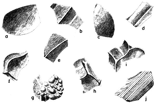
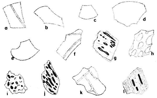
Particle shape--A consistent difference in the shape of the individual shards of Pliocene and Pleistocene ash was observed (note Fig. 2). The shards of Pliocene ash are flatter than those of Pleistocene ash, they generally possess fewer ridges caused by the juncture of glass bubbles, and the bubble walls are thinner. These features give the Pliocene ash a platy or micaceous appearance when compared under the microscope with the more angular Pleistocene material, and give the Pliocene ash a noticeably less gritty "feel" when rubbed between the fingers. Elongate fibrous glassy fragments (Fig. 2j) similar to the third type described by Ross (1928, p. 146) were observed in the Pleistocene samples.
Figure 2--Characteristic shards of Kansas volcanic ash, by reflected light. a-e, Pliocene ash from sample 7; f-j, Pleistocene ash from sample 47. Shards were selected to show significant differences between the two ages of ash. x 98.
Types of vesicles and inclusions--A marked difference was found to occur consistently in the internal texture of ash shards of the two different ages (note Fig. 3). The Pleistocene ash is characterized by many shards containing numerous elongated vesicles, commonly arranged in clusters or groups, whereas the ash shards from the Ogallala contain very few vesicles, and the few that were observed were not consistent as to shape. In some instances elongate parallel vesicles were found to be open at one or both ends where they intersect the surface of the shard (Fig. 3l). At several Pleistocene localities the characteristic vesicles were most abundant in shards from the upper part of the deposit. Few mineral inclusions were found in the fresh shards of all samples studied.
Figure 3--Characteristic shards of Kansas volcanic ash, by transmitted light. a-f, Pliocene ash from sample 2; g-l, Pleistocene ash from sample 60. Shards were selected to show significant differences between the two ages of ash. x 192.
Color--As was described by Landes (1928a, pp. 932, 933) a recognizable color difference between the samples of the two ages was observed. In general, the Pleistocene ash has more orange-yellow and less gray than does the Pliocene ash. The Ridgway color notation for each sample is given in Table 1.
Degree of alteration--In all cases where alteration minerals were recognizable with a petrographic microscope they displayed no stratigraphic or geographic significance. All alteration features, except color changes, were common to volcanic ash of both ages. A larger percentage of the Pliocene than of the Pleistocene samples studied showed effects of alteration. In one sample of each age alteration took the form of narrow anisotropic boundaries around the thin edges of the glass shards. The most altered samples contained many aggregates, yellowish brown or white in color, the composition of which was not determined. Judging from the few altered samples studied, the color of the deposits is modified by alteration to produce tints of yellow, orange-yellow, and green in the Pliocene deposits, whereas paler tints or even white result in the Pleistocene deposits. It is possible that this difference is due to the greater percentage of iron in the Pliocene ash.
Specific gravity--Values for the specific gravity of 7 Pliocene and 11 Pleistocene samples are given in Table 4. No significant differences were found between size grades except in sample no. 60. The specific gravity of the Pliocene samples studied ranges from 2.33 to 2.39, and that of the Pleistocene samples from 2.20 to 2.32.
Table 4--Specific gravity of 18 samples of Kansas volcanic ash.
| Sample no. |
Age | Location | Specific gravity (.177-.125 mm) |
Specific gravity (.088-.062 mm) |
|---|---|---|---|---|
| 1 | Pliocene | Norton County | 2.37 | |
| 2 | Pliocene | Norton County | 2.33 | 2.35 |
| 6 | Pliocene | Norton County | 2.35 | 2.34 |
| 7 | Pliocene | Norton County | 2.36 | 2.35 |
| 16 | Pliocene | Norton County | 2.37 | |
| 24 | Pliocene | Norton County | 2.34 | |
| 29 | Pliocene | Norton County | 2.36 | |
| 31 | Pleistocene | Seward County | 2.32 | 2.31 |
| 33 | Pleistocene | Meade County | 2.26 | 2.27 |
| 35 | Pleistocene | Meade County | 2.27 | |
| 36 | Pleistocene | Meade County | 2.31 | 2.32 |
| 40 | Pleistocene | Smith County | 2.27 | 2.29 |
| 41 | Pleistocene | Ness County | 2.32 | 2.32 |
| 45 | Pleistocene | McPherson County | 2.30 | 2.28 |
| 51 | Pleistocene | Lincoln County | 2.32 | |
| 52 | Pleistocene | Lincoln County | 2.30 | |
| 58 | Pleistocene | Sheridan County | 2.28 | 2.29 |
| 60 | Pleistocene | Sheridan County | 2.21 | 2.26 |
The differences in specific gravity between Pliocene and Pleistocene samples may be due to one or both of two factors: (1) the presence of numerous vesicles in the Pleistocene ash, and (2) the higher percentage of iron in the Pliocene material. George (1924, p. 363) plotted specific gravity of natural glasses against percentage of iron oxides and other constituents, and showed that glasses containing less than 2 percent iron oxides had a specific gravity of less than 2.33, whereas those with more than 2 percent had a higher gravity. The fact that in the samples here described iron oxide content alone is not the controlling factor as to gravity is shown by the lack of consistency of relationship of iron content to gravity in the samples determined, particularly in those of Pleistocene age (Fig. 4).
Figure 4--Relation of specific gravity (0.088-0.0,6;2 mm fraction) to percentage of ferric oxide in several volcanic ash samples. Pliocene samples are designated by crosses, Pleistocene samples by circles.
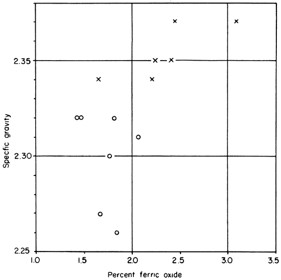
George (1924, p. 362) showed the effect of fine pores on specific gravity determinations by grinding a specimen of pumice to several degrees of fineness and getting a variation of from 2.249 to 2.389. Sample no. 60 of the present study was collected from a small cross-bedded lens which contained coarser and more vesicular shards than the surrounding ash. The specific gravity of ash from this lens was lower than that of the comparable grade size from the surrounding ash, and in the coarser fraction possessed the lowest specific gravity of any sample determined. This observation indicates that the relative abundance of vesicles in the shards may have an important bearing on the specific gravity. Whether the differences in the ash samples are due to chemical composition or to the effect of vesicles, they appear to be of diagnostic value.
The relation shown by George (1924, p. 367) of specific gravity to refractive index is similar to that found by us. Samples on his graph with a refractive index of approximately 1.50 ranged in specific gravity from 2.20 to 2.38.
Prev Page--Petrography || Next Page--Conclusions
Kansas Geological Survey, Geology
Placed on web Aug. 10, 2007; originally published April 1946.
Comments to webadmin@kgs.ku.edu
The URL for this page is http://www.kgs.ku.edu/Publications/Bulletins/64_1/04_char.html