Kansas Geological Survey, Bulletin 60, Part 3, originally published in 1945
Originally published in 1945 as Kansas Geological Survey Bulletin 60, Part 3. This is, in general, the original text as published. The information has not been updated.
Major stream valleys of central Kansas have been cut to depths of more than 200 feet below the top of the Pliocene Ogallala formation. The top of the Ogallala is marked by discontinuous thin deposits of "Algal limestone" which is believed to have been deposited over an extensive fluvial plain, approximately at the level of present ridges, prior to erosion of the present valleys. Recently this "Algal limestone" has been observed at 12 localities atop the Saline-Smoky Hill Divide in Russell, Lincoln, and Ellsworth counties, east of any previously described exposures. It here rests directly on Cretaceous shale and chalk. The geographic and topographic position of these exposures suggests that the "Algal limestone" was formed in lakes which occupied consequent depressions and abandoned channel segments on a piedmont alluvial plain. This interpretation furnishes a stratigraphic datum for measuring erosion in post-Ogallala time. After deposition of the "Algal limestone," major streams of this area cut through more than 150 feet of bedrock prior to the Wilson Valley fill of possible Kansan age. Since about Kansan time the Saline River has eroded more than 150 feet of bedrock plus a probable 60 feet of Pleistocene fill, and the Smoky Hill River has eroded 75 feet of bedrock plus a probable 60 feet of valley fill.
In central Kansas the Saline and Smoky Hill rivers flow eastward across Russell, Ellsworth, and Lincoln counties in broad, relatively deep valleys cut in limestone, shale, and lenticular sandstone of Cretaceous age.. They form the southernmost elements of the Kansas River Basin, and by way of that stream their waters ultimately join the Missouri River at Kansas City. Although the confluence of Saline and Smoky Hill rivers is at Salina, a short distance east of these counties, their valleys across this area have several important differences. The Smoky Hill Valley is broad and bordered by extensive high-level terraces; the Saline Valley is cut deeper below the upland surface, is narrower, and contains only small disconnected terrace remnants. The belt of outcrop of the several Cretaceous formations trends generally northeast-southwest across central Kansas, and regionally the eastern limit of the Greenhorn limestone forms an east-facing cuesta.
A prominent terrace occurs within Smoky Hill Valley at a level about intermediate between flood plain and upland. Exposures of Cretaceous rocks are common where minor stream dissection has cut through the cover of unconsolidated Pleistocene deposits. Wilson Valley, an abandoned high-level valley, extends across the present divide (Fig. 1) and during early Pleistocene time carried the drainage from the upper Saline Basin into the Smoky Hill. The terraces and abandoned Wilson Valley have been described by Frye, Leonard, and Hibbard (1943). The recent discovery of deposits referable to the so-called Algal limestone, uppermost unit of the Ogallala, on the highest part of the divide between Saline and Smoky Hill Valleys establishes an approximate date for the surface below which these two valleys are cut. In order to measure the amount of erosion that has occurred in these valleys since the "Algal limestone" was formed it is necessary to consider the mode of deposition of this limestone.
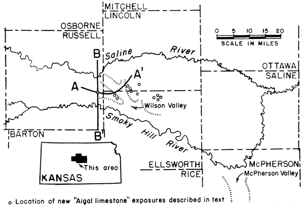
Figure 1--Map showing location of this area within the state of Kansas, the location of cross sections in Fig. 2, and the location of "Algal limestone" localities.
In 1931, Elias described the geology of Wallace County, Kansas. In his discussion of the Pliocene Ogallala formation in that county and adjacent counties of northwestern Kansas, eastern Colorado, and southwestern Nebraska he described occurrences of an unusual limestone that marks the top of the formation throughout much of this region. His description of this bed, in part, is as follows (Elias, 1931, p. 136):
On the top of these beds [Ogallala] there was observed a peculiar and remarkably persistent hard limestone, which was traced not only over the larger part of Wallace county but also far north, west and south in the adjacent area. This ledge of limestone is only 2 to 3 1/2 feet thick. It has an irregularly pitted surface and is made of unstratified, hard, compact, usually pinkish limestone and has a peculiar concentrically banded structure, which resembles closely that of the algal reefs and irregular pisolites of the Green River formation recently described by Bradley. . . . It is quite clear. . . . that the bed belongs to the Ogallala and is the capping rock of the section.
Concerning the origin of this deposit, which Elias referred to as the "Algal limestone" or "Chlorellopsis limestone," he stated (Elias, 1931, p. 141):
The pink concentrically banded limestone of the Ogallala, which, as shown above, is most probably a compound (phytogenic and hydrogenic) sheet reef, preserves a remarkably persistent texture and uniform thickness (2 to 3 1/2 feet) in all studied exposures, and the impression of the writer is that this rock was deposited on the nearly flat bottom of a very large and very shallow lake at the close of Ogallala time.
. . . The alga of today related to fossil Chlorellopsis . . . is known to precipitate calcium carbonate along the shores of lakes and not in running waters.
The lithology that characterizes this zone can most readily be recognized in the field by the concentrically banded structure, which differs from that of secondary tufa or travertine incrustations or solution surfaces in that the banding in the "Algal limestone" is not parallel to the underlying limestone surface but may be at high angles to it. Irregular pisolites are also common. This rock can be distinguished from soil caliches by its greater induration, concentrically banded structure, and lack of the disconnected nodular form. It can be distinguished from the silicified zones which occur near the top of the Ogallala by its dominant calcium carbonate composition.
During the summers of 1944 and 1945, formerly unknown exposures of this limestone were discovered in east-central Russell County, northern Ellsworth County, and southwestern Lincoln County, Kansas (Fig. 1). These localities extend the known geographic range of this deposit eastward in Kansas more than 40 miles. The outcrops of "Algal limestone" occur atop the present upland divide between the Saline and Smoky Hill Rivers both east and west of the abandoned high-level Wilson Valley, (Frye, Hibbard, and Leonard, 1943).
The manuscript for this paper has been improved by suggestions and criticisms from S. C. Happ, R. C. Moore, and A. C. Trowbridge. M. K. Elias has examined samples from the new localities described and has pronounced them examples of the "Chlorellopsis" limestone.
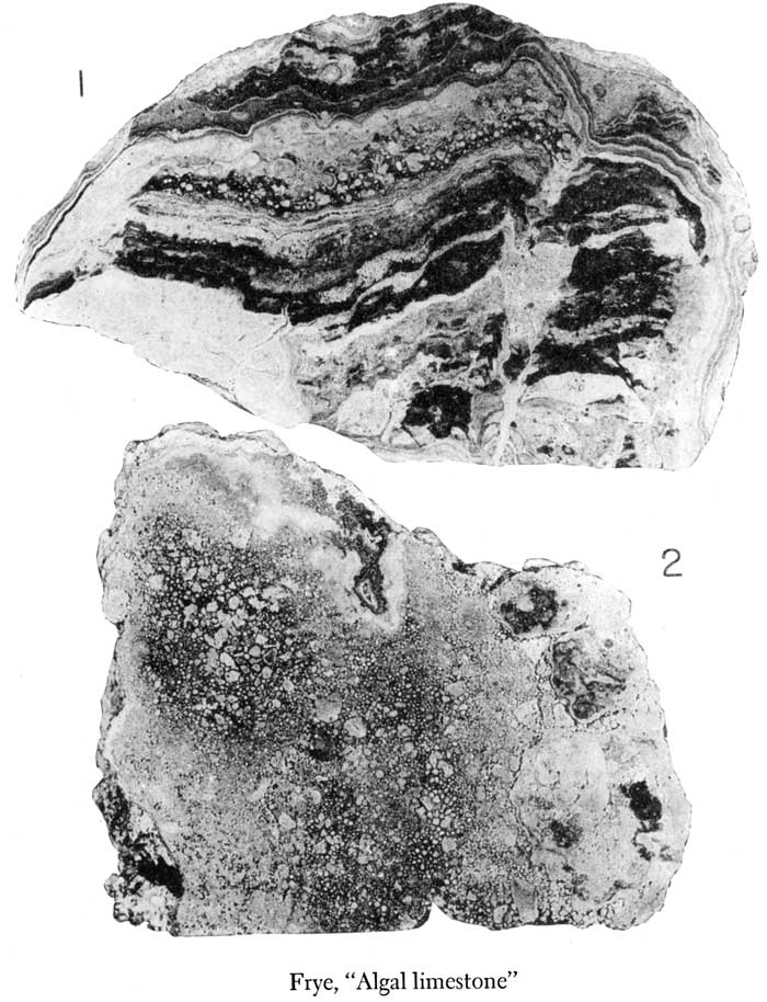
In east-central Russell County an exposure of the Ogallala formation, consisting mostly of "Algal limestone," was found along a shallow road cut at the cen. E. line sec. 3, T. 14 S., R. 11 W., and at the crest of a slightly higher point on the ridge about 100 yards to the west. The total vertical distance from the Ogallala-Greenhorn limestone (Cretaceous) contact to the top of the highest point on the divide is about 10 feet. The base of the exposure consists of blocks of chalky limestone (Greenhorn) and a few fragments of brown sandstone, resembling the sandstone of the Cretaceous Dakota formation, cemented with calcium carbonate. Algal-like structures, shown in Plate 1, figure 2, are abundant in the rock 2 to 2 1/2 feet above the base and are well developed in the weathered blocks (Pl. 1, fig. 1) at the highest point on the divide where the bed does not contain recognizable fragments of the Cretaceous bedrock. Elias examined the exposure in the field in 1944 and pronounced it a true example of the "Chlorellopsis limestone." Polished surfaces and thin sections display the same characteristics as the "Algal limestone" where it has been described farther west. The insoluble residue of the rock, where free from recognizable fragments of Greenhorn limestone or Dakota sandstone, contains many angular to subrounded quartz grains. The crest of the exposure is at an altitude of approximately 1,850 feet.
Plate 1--Polished surfaces of "Algal limestone" from east-central Russell County, Kansas (x1.5). Fig. 1--Weathered block of "Algal limestone" collected about 100 yards west of cen. E. line sec. 3, T. 14 S., R. 11 W., from crest of knoll that marks the highest point in the local topography. Fig. 2--Sample of "Algal limestone" collected from road cut exposure at the cen. E. line sec. 3, T. 14 S., R. 11 W., about 2 1/2 feet above the contact of the Ogallala formation and the Greenhorn limestone. This plate also available as an Acrobat PDF version at higher resolution.
Another exposure of "Algal limestone" was found at the crest of the west valley wall of the abandoned Wilson Valley, in the SW SW sec. 10, T. 14 S., R. 10 W., northwestern Ellsworth County, about 5 1/4 miles east of the Russell County locality. About 2 feet of this limestone is exposed along a road ditch, and small fragments of float were observed in a plowed field that extends to the north of the road. This field contains the highest point in the local topography, which is about 4 feet above the level of the road ditch exposure and at an altitude of approximately 1,800 feet.
Float blocks of "Algal limestone" were observed resting on Greenhorn limestone along a road ditch well up on the west valley slope of Wilson Valley at the cen. E. line SE SE sec. 15, T. 14. S., R. 10 W. The limestone was not found in place at this locality.
East of Wilson Valley, in southwestern Lincoln County and northern Ellsworth County, the Saline-Smoky Hill Divide broadens into a more extensive upland plain that locally is relatively undissected. Exposures of "Algal limestone" were found in this general area during July, 1945. These exposures, briefly described below, are in the highest parts of the upland at elevations ranging from about 1,770 to 1,820 feet. The beds below the Tertiary deposits,, where exposed, consist of chalky shale of the Greenhorn limestone.
In Lincoln County the "Algal limestone" was observed along a road ditch in the SW SW sec. 20, T. 13 S., R. 9 W. About 1 foot of rock was exposed just east of the crest of the east valley wall of Wilson Valley and a few feet of loess-like material occurs at a higher level along the crest of the valley wall. Less than 2 feet of this limestone was exposed in the road ditch at the cen. W. line SW sec. 28, T. 13 S., R. 9 W., at the level of the upland surface. At the cen. W. line SW sec. 24, T. 13 S., R. 9 W., less than 2 feet of "Algal limestone" was exposed at the crest of a valley wall in a road cut directly in contact with chalky shale of the Greenhorn limestone.
In Ellsworth County six exposures of "Algal limestone" were observed east of Wilson Valley. The easternmost of these exposures is along a road ditch at the rim of a small valley in the SW cor. sec. 12, T. 14 S., R. 8 W. A few feet of Greenhorn limestone underlain by Graneros shale is exposed lower on the valley side. At this locality the limestone has an oolitic texture but the banding, so prominent in exposures farther west, is poorly developed.
At the cen. W. line SW sec. 14, T. 14 S., R. 8 W., the "Algal limestone" is poorly exposed along a road ditch. At the cen. E. line sec. 10, T. 14 S., R. 8 W., weathered blocks and boulders were found at the crest of a steep valley wall just below the upland level and above a small abandoned quarry in the Greenhorn limestone. At the cen. S. line sec. 8, T. 14 S., R. 8 W., about 1 1/2 feet of weathered "Algal limestone" overlain by brown silt was exposed in gullies in a plowed field.
The limestone was observed along a road ditch at the top of the east valley wall of Wilson Valley, in the cen. N. line NW sec. 4, T. 14 S., R. 9 W.
Along a deep road ditch at the cen. N. line NE sec. 11, T. 14 S., R. 9 W., a section of Ogallala is exposed above the Greenhorn limestone. The lower part of the Ogallala consists of 3 to 4 feet of conglomerate composed of fragments of Greenhorn limestone and chalky shale with some clay and silt. This conglomerate is overlain by a 2-foot bed of banded "Algal limestone" that contains sand grains and fragments of Greenhorn limestone, and about 1 foot of oolitic limestone. More than 5 feet of loess-like silt overlies the Tertiary and forms a small knoll.
Elias (1931) believed that this limestone was deposited in a very broad, shallow lake that must have extended over virtually all of the High Plains and parts of the Plains Border provinces in Kansas, and beyond the limits of Kansas to the north, west, and south. He proposed this hypothesis of origin as supplying an environment similar to that in which near relatives of Chlorellopsis are now known to live. Theis (1936), writing about the Ogallala of the Llano Estacado, stated concerning the "Algal limestone": "The limestone at the top of the Ogallala formation is distinct from any other 'caliche' bed in the Ogallala and forms the one key bed in the Ogallala that can be traced practically throughout the High Plains from the southern edge of the formation northward at least to Nebraska." Theis (1936, pp. 391, 392) concluded that this limestone was formed in pools produced by a rising water table--the further rise of the water table causing overflow of the pools and "integration of surface drainage, with consequent rapid dissection and lowering of the water table, eventually to its present position."
Trowbridge (1926; 1933, pp. 184-203), in describing the Reynosa formation of the lower Rio Grande region of Texas, presents a depositional history similar in many respects to the Pliocene history of the central High Plains. He believed that the limestone of the Reynosa was contributed mainly by ground water and perhaps to some extent by the streams, precipitation taking place in the interstices of the gravel, in the vicinity of springs, and in sloughs and other depressions and shallow flats where stream water evaporated rapidly. Price (1933, pp. 502-520; 1933a, pp. 1268-1270; Baker, 1933, p. 1534) has discussed the origin of caliche and classified the various occurrences into young, mature, and old age types, expressing the belief that most caliche deposits have been formed by a leaching and downward concentration of calcium carbonate of the soil. In 1940 Price (p. 1939) stated: "Surface indurations of caliche and tufas, including oolites, pisolites, and 'algal limestones' found with caliche, were probably formed by evaporation or plant agency on moist surfaces and in lakes of humid periods."
Smith (1940, pp. 90-92) has critically discussed the origin of the "Algal limestone" and supposed corellary deposits in southwestern Kansas which he refers to as the "capping limestone," and has raised serious objections to the hypothesis that it was deposited in a single large shallow lake. He states (pp. 90, 91):
Such a lake must have been of enormous size, extending from Nebraska to the Oklahoma panhandle or farther, and from Barton county, Kansas, west into Colorado. The considerable difficulties attending this hypothesis are mainly those of satisfactorily explaining the origin of such ponding. If it be granted that upwarping in the plains area was a factor in leading to the deposition of the Ogallala, it follows that a renewal of such movement might result in ponding of streams from the mountains. Even assuming these conditions, however, there is a strong probability that a balance between inflow and evaporation would have been reached long before the lake or lakes, in question attained required size. Furthermore, the amount of uplift necessary to produce a horizontal water surface of the extent postulated would have been much greater than that required merely to flatten stream gradients sufficiently to induce deposition. It, must have amounted to hundreds of feet, and therefore would be expected to have left some tangible evidence of its existence. The required shallowness of the postulated ponding presents added difficulties, which demands so delicate a graduation in the amount of uplift from east to west over so large an area as to be challenged by probabilities. Finally, it may be noted that the trend of the postulated uplift would be required to have been nearly transverse to that of the uplift which must have followed shortly thereafter, and which was responsible for the present drainage pattern.
Although Smith (1940, p. 91) states that a final solution to the problem of "Algal limestone" origin is not yet possible, he presents factors favoring a "caliche hypothesis" that does not require lakes or extensive algal growths. All known localities of this limestone contain the particular structures referred by Elias to Chlorellopsis bradleyi. If Elias' identification of these structures is accepted--and his original description presents strong arguments for its acceptance--then any mode of origin postulated for this deposit must provide an environment of shallow, stagnant, or very sluggish water. Further, such an environment must have existed at many places widely distributed over the High Plains and Plains Border provinces. It must also have existed both on as much as 500 feet of upper Tertiary clastic deposits and on the exposed surface of the Greenhorn limestone. Smith (1940) and later Frye (1942, p. 101), in discussing caliche beds in the Tertiary deposits of Meade County, Kansas, incorrectly correlated a resistant calcareous bed that is locally silicified with the "Algal limestone." Although this bed caps a partial section of Ogallala, recent field work, supplemented by field examination of fossil seeds by Elias, indicates that it is not a stratigraphic equivalent of the "Algal limestone" of other parts of the High Plains, but is somewhat lower stratigraphically. Therefore, the absence of algal structures and other typical features from exposures in the Meade Basin are of no significance in a consideration of the origin of the "Algal limestone."
In view of Smith's criticisms of the tectonic history involved, Elias' theory of a very widespread, shallow, and continuous lake seems unacceptable. The immediate environment of deposition demanded by Elias for algal growth evidently could not be provided by the "caliche hypothesis" more favorably presented by Smith. Theis' hypothesis of deposition in unconnected lakes seems to hold more promise, as such lakes could have existed in an area having a regional slope comparable to that of the High Plains and would have provided a proper environment for the growth of algae. However, Theis did not discuss the origin of the depressions and why it was necessary to postulate (1936, p. 392) "overflow of the pools and integration of surface drainage."
The deposits in western Kansas that comprise the Ogallala formation below the "Algal limestone" are mostly gravel, sand, and silt in lenticular and discontinuous beds which, have the characteristics of stream-channel and flood-plain sediments. At the beginning of Ogallala deposition in the central High Plains, streams were flowing in broad, mature valleys, and, judging from the preponderance of sand and gravel, the low degree of sorting exhibited by many beds, the scarcity of clay beds, and the presence of at least small percentages of sand or gravel in the silt beds, these materials were deposited fairly rapidly by vigorous streams and a sizable percentage of the formation represents channel deposits. In western Kansas these deposits accumulated to the level of divides in the former bedrock topography and spread across them forming a "piedmont alluvial plain" (Smith, 1940, p. 78), which at the end of Ogallala deposition may have been continuous with the erosional plain in the Rocky Mountain region (Fenneman, 1931, p. 107). It seems quite likely that this surface continued eastward to about central Kansas, beyond which the Flint Hills formed a north-south divide.
Such a depositional environment as this must have resulted in some consequent irregularities on the surface of the alluvial plain. Maximum deposition would occur along and immediately adjacent to the stream channels, leaving depressions in the interchannel areas. During the period of active alluviation, the streams, when at flood stage, would often break through or overflow their natural levees and carry clastic material into the lower areas, and thus interrupt any calcium carbonate accumulation that might otherwise have occurred in these depressions. After active alluvial upbuilding of the High Plains region ceased lakes might persist in these depressions for a much longer time, thus providing an environment in which the "Algal limestone" might have been formed without recourse to the complicated diastrophic movements objected to by Smith. As Theis (1936) has pointed out, it seems probable that at this time the water table in this entire region stood at a sufficiently high level that the consequent depressions and abandoned channel segments would have been occupied by lakes.
It is not known how long these lakes existed before they were drained by the lowering of the water table. It may be that the change from deposition to erosion by the High Plains streams was occasioned by differential tilting (Smith, 1940, p. 84) which may also have given rise to the semiradial drainage pattern in the region to the northwest of the area here under consideration. If this were the case, the postulated lakes in which the "Algal limestone" was formed could have existed until such time as the downcutting of the streams lowered the water table sufficiently to make permanent lakes impossible. This would permit dissection of the region without overflow of the lakes and would allow a longer history for lakes remote from the master streams--thus "Algal limestone" might have continued to form in some lakes while similar deposits were being eroded in other areas. However, such a history does not signify that the lenticular limestone deposits have smaller value as a stratigraphic datum, since they mark the top of the widespread Ogallala formation representing time just prior to a widespread erosion interval. This erosion extended over most of the western Kansas region except in such solution-subsidence or down-faulted areas as the Meade Basin.
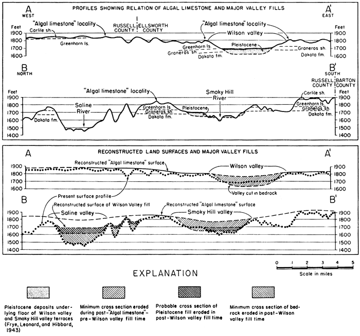
In 1943, Frye, Leonard, and Hibbard (pp, 36, 37) described a high-level abandoned valley that extends across the Saline-Smoky Hill Divide in northwestern Ellsworth County and southwestern Lincoln County, Kansas (Figs. 1, 2). They described the deposits that occur on the floor and their contained Pleistocene fossils and discussed the history of the valley. The presence of Tertiary deposits on the upland divides adjacent to the abandoned valley was not known in 1943, and the occurrences of "Algal limestone" on this upland here described serve to establish the approximate position of the surface at the end of the time of Ogallala deposition. They indicate that the land surface had low relief, somewhat as shown in Figure 2. This surface furnishes a dated starting point for an epoch of valley incision that was terminated before deposition of the sediments covering the floor of Wilson Valley and containing the Wilson Valley, Tobin, and Rezabek faunules (Frye, Leonard, and Hibbard, 1943) of early to mid-Pleistocene age. Cross sections (Fig. 2) show that the maximum depth of erosion of Wilson Valley through Cretaceous bedrock across the position of the present Saline-Smoky Hill Divide, and also the maximum erosion of the high-level Smoky Hill Valley 2 miles west of the Russell-Ellsworth County line, was more than 150 feet. The cross-sectional areas removed by erosion along these two lines indicate that nearly 500 million cubic yards of rock per linear mile was removed from each valley. All evidence of the high-level drainage has been removed from the present Saline Valley in western Lincoln County and eastern Russell County so that the amount of erosion in that valley during this epoch cannot be measured.
Figure 2--Sections across Wilson Valley and Saline and Smoky Hill valleys. A-A', section along crest of Saline-Smoky Hill Divide; B-B', north-south section across Saline and Smoky Hill valleys through the Russell County "Algal limestone" locality. Sections plotted from Russell and Ellsworth quadrangles of the United States Geological Survey.
These features furnish a relatively satisfactory measure of net stream incision between two geologic time markers, the "Algal limestone" of late Pliocene age and the Wilson Valley deposits of early or mid-Pleistocene age. The positions of these time markers within the Great Plains chronology, which is based on vertebrate fossils, are known. In this chronology this interval presumably included all of Blancan time (Elias, Frye, Hibbard, Reed, and Schultz, 1945), as the "Algal limestone" is believed to be older than the Blancan fauna and the Pleistocene fauna from the Wilson Valley deposits is believed to be younger.
The absolute amount of time represented between the "Algal limestone" and the Wilson Valley fill is not known, and this interval can be placed only approximately in the standard time scale. The "Algal limestone" has been variously dated from latest middle Pliocene (Frye and Hibbard, 1942) to the close of the Pliocene (Lugn, 1939, p. 1266; Elias, 1942, pp. 146, 147). The Pleistocene fill of Wilson Valley is believed to be approximately equivalent to the McPherson formation (restricted) of McPherson County to the east (Frye, Leonard, and Hibbard, 1943, p. 46; Frye, 1945, p. 82) which had been tentatively correlated with the time of the Kansan glaciation (Lohman and Frye, 1940, p. 846). The Wilson Valley faunas have been correlated by Hibbard (1944, pp. 740-742) with the Cudahy fauna of the "lower Meade" in Meade County, Kansas, which is believed to belong in early Pleistocene time. Thus the interval of valley incision may have been as short as from very late Pliocene to earliest Pleistocene or it may have been as long as from latest middle Pliocene to about the time of the Kansan ice sheet.
The reconstruction of the valley floors along the lines of the cross sections in Figure 2, just prior to entrenchment of streams through early Pleistocene deposits, is based on the drainage history of this area presented by Frye, Leonard, and Hibbard (1943). The Saline Basin west of the Russell-Lincoln County line drained southeastward across the floor of the now abandoned Wilson Valley and joined the ancestral Smoky Hill in western Ellsworth County. An unknown but probably small part of the present Saline Valley east of this confluence flowed south-southwestward into the Wilson Valley stream. After the Flint Hills Divide was breached by the present Kansas River (probably during or just after the retreat of the Nebraskan or Kansan ice sheet from its maximum extent) and the now-filled McPherson Valley that formerly conducted the Smoky Hill-Saline drainage southward across western McPherson County to the ancestral Arkansas Valley was abandoned, the Smoky Hill River took its present course, shown in Figure 1. It is not yet known whether the eastward diversion of the Saline occurred before or after the eastward diversion of the Smoky Hill.
The capture of the present Saline and the abandonment of Wi1son Valley mark the initiation of a second segment of geologic time during which erosion of Saline and Smoky Hill valleys at the position of cross section B-B' can be evaluated. This erosion interval started after the major stream diversion from southward to eastward and after the deposition of the beds containing the Wilson Valley, Rezabek, and Tobin faunules of early or mid-Pleistocene age (Frye, Leonard, and Hibbard, 1943; Hibbard, 1944). This point in time may have been as late as mid-Pleistocene but not earlier than late Aftonian. Whether the incision of this valley was continuous or was interrupted at times is not known. With possible interruptions, this erosion interval may have continued to the present; however active erosion may have terminated at a somewhat earlier time.
The drainage history outlined above explains the discrepancy in the magnitude of erosion in Saline and Smoky Hill Valleys shown in Figure 2. Actually, this discrepancy is even greater than shown by the cross section, inasmuch as the pre-erosion surface postulated for the Saline Valley along the line of the cross section is at the same elevation as the respective existing surfaces in Wilson Valley about 2 miles down the ancestral stream and thus possibly more than 20 feet lower, whereas the surfaces postulated for the Smoky Hill Valley along the same cross section are reconstructed from existing Pleistocene fill and bedrock terrace surfaces.
On the basis of the cross sectional areas shown in Figure 2, a minimum of about 210 million cubic yards of Pleistocene fill and about 270 million cubic yards of Cretaceous bedrock, or nearly a half billion cubic yards of material per linear mile of valley, have been removed from Saline Valley since this downcutting started at about mid-Pleistocene time. This has resulted in deepening the valley by at least 215 feet, of which 150 feet was through Cretaceous bedrock. The width of the "modern" Smoky Hill Valley is much less than that of the Saline Valley (Fig. 2). The Smoky Hill has cut through only about 60 feet of Pleistocene deposits plus about 75 feet of bedrock--a total of about 135 feet of deepening. The cross sectional areas shown in Figure 2 indicate about 100 million cubic yards of Pleistocene deposits and about 32 million cubic yards of bedrock per linear mile of valley removed from the Smoky Hill Valley during this same interval of time.
New localities of "Algal limestone" which extend the known range of this deposit more than 40 miles to the east are described. A review of the several hypotheses expressed for the origin of this unusual limestone leads to the conclusions that it was formed in lakes which occupied consequent depressions and possibly also, abandoned channel segments, and that its accumulation was terminated by the entrenchment of streams at the beginning of the post-Ogallala erosion cycle.
During post-"Algal limestone" and pre-Wilson Valley fill time (latest middle to latest upper Pliocene, to early to mid-Pleistocene), the master streams of this area lowered their valleys through Cretaceous strata (Greenhorn limestone, Graneros shale, Dakota formation) by more than 150 feet, with an estimated removal of a half billion cubic yards of material per linear mile of valley. It is not known during what percentage of this time span erosion was actively in progress. Since the deposition of the Pleistocene fill, Wilson Valley has been abandoned, Saline River in eastern Russell County has lowered its valley through more than 215 feet of Pleistocene deposits and Cretaceous bedrock, and Smoky Hill River has eroded its valley through about 135 feet of Pleistocene deposits and Cretaceous bedrock. The drainage history of the region and the presence of terraces at intermediate levels suggest that only a fraction of the time since mid-Pleistocene was utilized to accomplish this erosion.
Baker, C. L., 1933, Reynosa problem of south Texas and origin of caliche (discussion): Am. Assoc. Petroleum Geologists, Bull., vol. 17, no. 12, p. 1534.
Elias, M. K., 1931, The geology of Wallace County, Kansas: Kansas Geol. Survey, Bull. 18, pp. 1-254, figs. 1-7, pls. 1-42. [available online]
Elias, M. K., 1942, Tertiary prairie grasses and other herbs from the High Plains: Geol. Soc. America, Special Paper 41, pp. 1-176, fig. 1, pls. 1-17.
Elias, M. K., Frye, J. C., Hibbard, C. W., Reed, E. C., and Schultz, C. B., 1945, Blancan as a time term in the Central Great Plains: Science, vol. 101, no. 2620, pp. 270-271.
Fenneman, N. M., 1931, Physiography of western United States: McGraw-Hill Book Co., Inc., New York, pp. 1-543, figs. 1-173.
Frye, J. C., 1942, Geology and ground-water resources of Meade County, Kansas: Kansas Geol. Survey, Bull. 45, pp. 1-152, figs. 1-13, pls. 1-12. [available online]
Frye, J. C., 1945, Problems of Pleistocene stratigraphy in central and western Kansas: Jour. Geology, vol. 53, no. 2, pp. 73-93.
Frye, J. C., and Hibbard, C. W., 1941, Pliocene and Pleistocene stratigraphy and paleontology of the Meade Basin, southwestern Kansas: Kansas Geol. Survey, Bull. 38, pt. 13, pp. 289-424, figs. 1-3, pls. 1-4. [available online]
Frye, J. C., Leonard, A. B., and Hibbard, C. W., 1943, Westward extension of the Kansas "Equus beds": Jour. Geology, vol. 51, no. 1, pp. 33-47, figs. 1-3.
Hibbard, C. W., 1944, Stratigraphy and vertebrate paleontology of Pleistocene deposits of southwestern Kansas: Geol. Soc. America, Bull., vol. 55, no. 6, pp. 707-754, figs. 1-20, pls. 1-3.
Lohman, S. W., and Frye, J. C., 1940, Geology and ground-water resources of the "Equus beds" area in south-central Kansas: Econ. Geology, vol. 35, pp. 839-866, figs. 1-5.
Lugn, A. L., 1939, Classification of the Tertiary system in Nebraska: Geol. Soc. America, Bull., vol. 50, no. 8, pp. 1245-1275, pl. 1.
Price, W. A., 1933, Reynosa problem of south Texas, and origin of caliche: Am. Assoc. Petroleum Geologists, Bull., vol. 17, no. 5, pp. 488-522, figs. 1-5.
Price, W. A., 1933a, Reynosa problem of south Texas, and origin of caliche (discussion): Am. Assoc. Petroleum Geologists, Bull., vol. 1, no. 10, pp. 1277-1281.
Price, W. A., 1940, Origin of caliche (abstract): Geol. Soc. America, Bull., vol. 51, no. 12, pt. 2, p. 1939.
Smith, H. T. U., 1940, Geologic studies in southwestern Kansas: Kansas Geol. Survey, Bull. 34, pp. 1-244, figs. 1-22, pls. 1-34. [available online]
Theis, C. V., 1936, Possible effects of ground-water on the Ogallala formation of Llano Estacado: Washington Acad. Sci. Jour., vol. 26, no. 9, pp. 390-392.
Trowbridge, A. C., 1926., Reynosa formation in lower Rio Grande region, Texas: Geol. Soc. America, Bull., vol. 37, no. 3, pp. 455-462, figs. 1-3.
Trowbridge, A. C., 1932, Tertiary and Quaternary geology of the lower Rio Grande region, Texas: U.S. Geol. Survey, Bull. 837, pp. 1-260, figs. 1-76, pls. 1-20. [available online]
Kansas Geological Survey, Geology
Placed on web Sept. 23, 2008; originally published in Dec. 1945.
Comments to webadmin@kgs.ku.edu
The URL for this page is http://www.kgs.ku.edu/Publications/Bulletins/60_3/index.html