![]()
Prev Page--Geography, Mining Methods || Next Page--Mine Data
Coal in the Douglas Group
Stratigraphy
Physical Boundaries
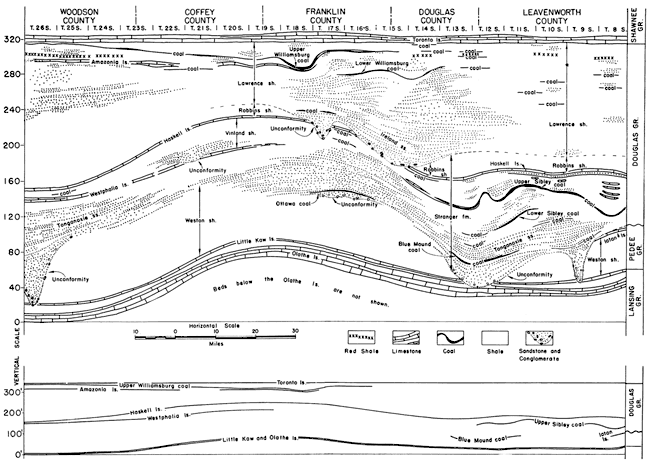
The lowermost deposits of the Virgilian series (table 1; fig. 8), primarily marine clastics in which bodies of massive or cross-bedded sandstone, shaly sandstone, and sandy shale predominate, compose the Douglas group (fig. 8). These Virgilian deposits are separated from the underlying rocks of the Missourian series by an unconformable contact and are conformably overlain by the lowermost beds of the Shawnee group. The lower boundary of the group is commonly marked by the presence of a buried erosion surface, while the upper boundary, although gradational, is well marked by the base of the Toronto limestone member of the Oread formation.
Table 1. Classification of the Pennsylvanian subsystem in Kansas.
| (unconformity) | |||
| Carboniferous system | |||
| Pennsylvanian subsystem | |||
| Virgilian series | |||
| Wabaunsee group | |||
| Shawnee group | |||
| Douglas group | |||
| (regional unconformity) | |||
| Missourian series | |||
| Pedee group | |||
| Lansing group | |||
| Kansas City group | |||
| Bronson group | |||
| Bourbon group | |||
| (regional unconformity) | |||
| Desmoinesian series | |||
| Marmaton group | |||
| Cherokee group | |||
| (regional unconformity, transgressive overlap) | |||
| Mississippian subsystem | |||
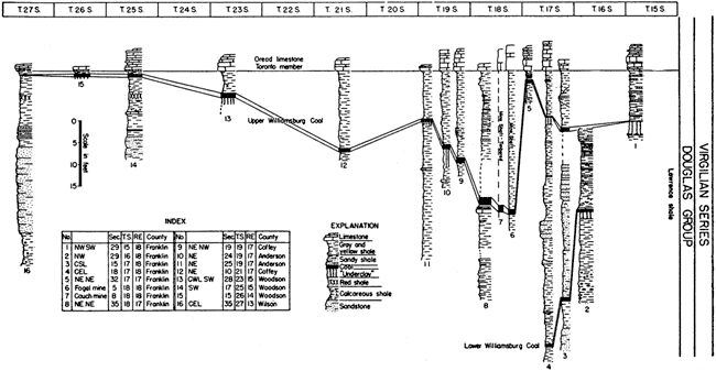
Figure 8. Diagrammatic cross sections of the Douglas and adjacent rocks. A larger version of this figure is available.
Divisions
The lowermost division of the group is the Stranger formation, which includes the channel sandstones at the base of the Virgilian series and the shaly beds above. The top of the Stranger is marked by the hiatus at the base of the Ireland sandstone. Data from outcrop measurements indicate a thickness of 60 to 153 feet for the strata included in the Stranger formation, which has an average thickness of about 90 feet. Channel sandstones are absent in the base of the Stranger formation in some areas, but in near-by localities they attain a thickness of 120 feet. In many places these deposits attain a thickness of 50 to 80 feet and are designated as the Tonganoxie sandstone (pl. 4). In Leavenworth County the Tonganoxie sandstone ordinarily exhibits a thick massive lower zone and a thin upper zone separated by less resistant thin-bedded sandstone or by silty shale. The lower sandstone zone ranges from 50 to 60 feet and the upper from 10 to 20 feet in thickness. The shaly zone that separates the two sandstones is about 15 feet thick. The Westphalia limestone, where present, generally lies 10 to 25 feet above the top of the Tonganoxie sandstone. The Westphalia limestone is absent throughout much of the northern part of the Douglas outcrop area, but it has a thickness of 5 feet or more in Anderson County. Along a part of the Douglas outcrop line the Sibley coal lies directly below a thin limestone that is correlated with the Westphalia limestone (fig. 8). The Vinland shale occupies the interval between the top of the Westphalia limestone and the base of the Haskell limestone. The Vinland shale ranges from 10 to 35 feet in thickness. The Haskell limestone, an extremely persistent bed that lies above the Vinland shale, is about 9 feet thick in Leavenworth and Douglas counties and is about 18 inches thick in Anderson County. It is commonly 2 or 3 feet thick where observed in Woodson County, but in a few exposures it is thicker. The uppermost bed of the Stranger formation is the Robbins shale member. It consists of remnants of a post-Haskell shale bed that was not completely removed by pre-Ireland erosion. In Douglas County only a few feet of the Robbins shale are present between the Haskell limestone and the overlying sandstone. Southward from Yates Center in Woodson County the Robbins shale thickens to an average of about 100 feet in southern Kansas. Massive sandstone bodies occur abruptly in the Robbins shale member in Chautauqua County.
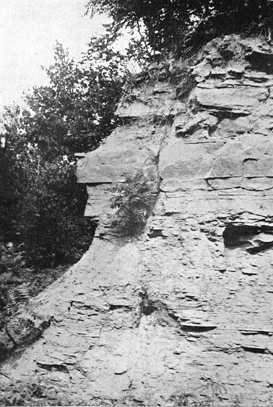
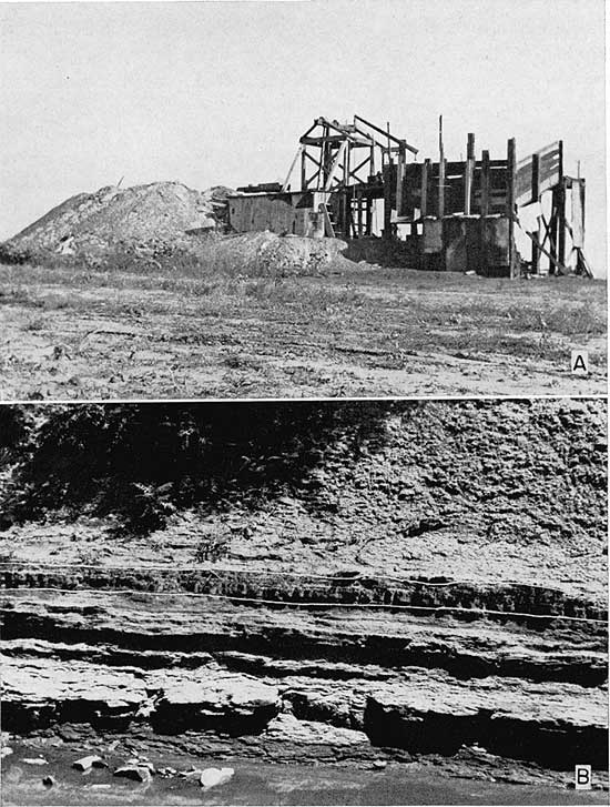
Plate 4. A. Exposure along U. S. Highway 50 S., SW cor. sec. 14, T. 17 S., R. 19 E., Franklin County, Kansas. B. A fossilized tree standing erect and rooted in the coal bed.
The uppermost division of the Douglas group is the Lawrence shale member. The Lawrence shale lies above the Robbins shale member and below the Oread limestone. Channel sandstone in the basal zone of the Lawrence shale locally attains a thickness of 70 or more feet. Collectively, these sandstones are known as "Ireland sandstone." The Ireland sandstone is bounded below by a regional unconformity but the upper limits are indefinite. The average thickness of this sandstone zone is between 40 and 50 feet. Sandstone bodies varying in thickness from 10 to 49 feet are developed erratically at two higher zones in the Lawrence shale. The upper of these sandstone zones apparently lies between the upper and lower Williamsburg coal beds. Evidence does not show whether this sandy zone is stratigraphically above or below the limestone correlated with the Amazonia limestone. Thin sandstone zones are developed locally in the upper few feet of the Lawrence shale. The total thickness of the Lawrence shale varies from about 70 to 160 feet. The Amazonia limestone in Franklin, Coffey, and Woodson counties averages 18 inches in thickness and lies approximately 30 feet below the base of the Oread formation (fig. 8). The Toronto limestone member, the lower bed of the Oread formation, is very persistent and occupies a position just above the Lawrence shale; it is 9 to 10 feet thick.
Physical Characteristics
The predominant lithologic types of the Douglas group are marine clay and silty shales. The micaceous texture of these clay and silt shales is very striking and often gives an erroneous impression as to the amount and size of the mica particles that the shale contains. Some shales which appear sandy prove to be dominantly silt or even clay shales.
Grim and his associates (Grim and Bray, 1937; Grim and Allen, 1938) have shown that both illite and kaolinite are important constituents of Pennsylvanian shales. It appears to be true that in deposits dominantly composed of kaolinite, there is a lack of the more common prominent bedding and that slickensided structures are shown on broken surfaces. Slickensides are not readily observed in the shales believed to be composed largely of illite. Thus the finer clastic deposits in the Douglas group are composed largely of mica-like clay minerals and the coarser clastics are composed principally of quartz particles. During his field studies, Mr. Bowsher noted that commonly there is a decrease in the ratio of megascopic mica flakes to quartz as the quartz grains approach sand size.
The sandstones, which represent the coarser clastics, vary from thick, massively bedded to thin, cross-bedded sand bodies (pl. 4). They are irregular in lateral and vertical distribution and grade somewhat abruptly into the surrounding clay and silt shales. Many of these sandstone bodies are channel fillings. Evidence of scouring and channel filling is conspicuous at the base of the Tonganoxie sandstone, which marks the base of the Douglas group and of the Virgilian series. The unconformity which marks this lower boundary is most readily discernible where the Tonganoxie sandstone rests on an eroded surface of Lansing beds. Conglomerates, which mark these erosional contacts, consist primarily of pebbles derived from indurated varicolored clay and silt shales enclosed in a matrix of clay, fine-grained quartz, sandstone, and siltstone. Contacts are sharp and pronounced where they lie at channel-scoured surfaces which locally cut completely through rocks of the Pedee group and deeply into the upper beds of the Lansing group. These channel-fill sandstones grade upward and laterally into the surrounding shales. As the contacts are traced from channel scour areas, they become indistinct and rise stratigraphically. The record of scouring and channel filling is present in many parts of the Douglas group. These conditions also obtain in a striking manner at the base of the Ireland sandstone, a sandstone which was developed irregularly in the lower part of the Lawrence shale. Conglomerates occurring at the base of the Ireland sandstone, although they contain some large angular fragments of coal (Rich, 1933), are composed, in general, of more resistant detritus than is seen in those at the base of the Tonganoxie sandstone. Channels containing the Ireland sandstone locally have been cut down to horizons lower than those of Westphalia limestone. Ireland sandstone channel fillings are numerous and well developed in northeastern Leavenworth, southeastern Douglas, and western Franklin counties, and are known in other Kansas counties.
Bituminous coal beds occur at many horizons in the Douglas group. Usually they are thin and only locally attain a thickness of more than a few inches. Most of these thin coal beds are exposed only at isolated outcrops, and there is little or no evidence by which they may be correlated from place to place.
Generally the coal is very thin bedded. It is composed essentially of altered, resistant parts of plants and fragmentary woody material. We have not observed even partially complete fossil plants, roots, or standing stumps in the coal beds or in the rocks immediately underlying the coal beds. Plant fragments in the coal are commonly compressed. Although several of the thicker coal beds extend over a considerable distance, it is believed that most of them are rather lenticular and have a considerable range in thickness in short distances. The coal beds, with few exceptions, grade almost imperceptibly into the underlying and overlying clay and silt shales. Most of the coal beds rest upon light gray to brownish gray, soft to hard, micaceous, well-bedded clay or silt shale. There is a gradation from silty coal downward into shale containing fragmentary carbonaceous plant remains and a few marine fossils. In several instances coal beds of this group seem to be underlain by bedded clay shale. These shales are dark gray, of variable carbonaceous and calcareous content. They range from nongritty to sandy shale, and exhibit many slickensided fractures that are not continuous into the underlying and overlying beds. Such clay shales differ from described "underclays" or "seat earths" in that these in the Douglas group are distinctly bedded, a feature generally absent from "underclays." A clay shale, however, seen beneath coal in the basal part of the Stranger formation, 1 1/2 miles southwest of Ottawa, is in many respects an "underclay" and may represent, an old soil (pl. 4). This clay shale has more of the characteristics of "underclays" as described from other areas than any other shale we have observed in the Douglas group. Even this shale which is probably kaolinitic does not seem to have all of the characteristics of a true "underclay." Coal beds of the Douglas group generally overlie clay and silt shale, probably illitic and of varying calcareous content, that seldom contain quartz sand grains or concretionary structures.
Rocks of the Douglas group, like those of the Cherokee and Bourbon groups, are dominantly clastic; the three groups lie above great regional unconformities. Thick marine limestones are notably absent. The Westphalia limestone, lowermost limestone in the Douglas group, lies approximately 100 feet above the top of the Stanton limestone. It is well developed in Woodson, Coffey, and southern Franklin counties. The lower portion is commonly conglomeratic, containing pebbles of shale. Fusulines are common throughout and are especially abundant in the upper part. The upper portion of the rock is a mass of the fusulinid Triticites secalicus oryziformis Newell, embedded in a sparse matrix of calcareous clay and silt. A thin, finely laminated, carbonaceous limestone which has been correlated with the Westphalia overlies the Sibley coal near Baldwin, Kansas.
The Haskell limestone, which lies 10 to 30 feet above the Westphalia limestone, is composed primarily of a lower very calcareous sandstone and an upper limestone zone. The lower zone ranges from a few inches to over 5 feet in thickness, and the upper one ranges from 1 foot to approximately 5 feet in thickness. The medial portion of the upper limestone zone is widespread and persistent. It is dark gray, hard, argillaceous limestone containing broken shell fragments. Conglomeratic, arenaceous, and oölitic facies were observed at some places in the base, and oölitic and crinodial facies occur at the top. A thin clay shale, several inches in thickness, containing nodules of oölitic limestone in which fish-brain casts are found, persistently overlies the Haskell limestone. This shale in turn is capped by a bed of highly ferruginous limestone. Septarian concretions occur at a distance of as much as 10 feet below the base of the lower zone of the Haskell limestone. This is a good marker zone and has been found to occur at irregular intervals along the outcrop from Leavenworth County to Franklin County. In northern Leavenworth County, a zone containing hard, dark gray, massive beds of argillaceous limestone is present at about this horizon (pl. 5; fig. 8, sec. 1; fig. 9). It is probable that this represents the northward extension of the limestone septarian concretion zone.
Plate 5. Exposure of argillaceous limestone in the Vinland shale, cen. sec. 4, T. 8 S., R. 22 E., Leavenworth County, Kansas.
In Woodson, Coffey, and Franklin counties, a light gray, hard dense, banded limestone, which locally becomes extremely argillaceous, lies about 30 feet below the base of the Oread limestone. This limestone is tentatively correlated with the Amazonia limestone on the basis of stratigraphic position. In Woodson County the Amazonia (?) limestone is argillaceous and averages 16 inches in thickness (pl. 2B). In that county it is separated from the overlying Williamsburg coal bed by about 25 feet of clay shale. In Franklin County, the coal rests directly upon the Amazonia (?) limestone which consists of a concretionary upper bed, and a dense, hard, laminated lower portion.
Subsurface Relationships
More than 150 well logs compiled from cuttings were examined in an effort to extend and check information obtained from field work on rocks of the Douglas group. Well logs were chosen near the exposure of the rocks, but at such a distance down-dip that the drill had passed through all beds of the Douglas group. The stratigraphic relationships as shown by well cuttings are in accord with those formulated from field data. The rocks of the Douglas group are only 100 feet thick in the Umsheid No. 1 Turner well, sec. 32, T. 15 S., R. 18 E., but have a maximum thickness of 340 feet or more in sec. 7, T. 15 S., R. 8 E. Logs of wells along a line passing through Ts. 12, 14, 15, and 18 S. indicate that the Tonganoxie sandstone bodies in the townships listed above have the characteristics of channel fillings. It evidently is a zone of more or less discontinuous sandstone bodies which are only locally differentiated into an upper and lower zone. Although this zone ranges in thickness from 50 to 120 feet, it has an average thickness of between 80 and 90 feet in the area north of T. 18 S. The Tonganoxie sandstone was not identified in logs through Ts. 22 and 25 S. The Westphalia limestone lies approximately 120 feet above the top of the Stanton formation in T. 25 S., and 50 to 90 feet above it in T. 22 S. Limestone occurs only sporadically in the horizon of the Westphalia limestone north of T. 22 S. The Vinland shale is about 10 feet thick in T. 25 S., but thickens to 35 or 40 feet in T. 22 S. A zone of channel sandstone beds which are developed abruptly in the Vinland shale cut out the Westphalia limestone in T. 22 S. The Haskell limestone is a very persistent bed that generally lies 120 feet below the Oread formation, although in some places it is 190 feet or more below the Oread. The average thickness of the Lawrence shale in the subsurface in east-central Kansas is about 120 feet. The pre-Ireland erosion surface, which marks the base of the Lawrence shale, cuts below the Haskell limestone in Ts. 14, 18, and 22 S., and Ireland sandstone bodies are present. The sandstone bodies in the Lawrence shale are local and discontinuous, but the basal zone of channel sandstone lenses ranges from 50 to 60 feet in thickness. Two higher unnamed sandstone zones average 30 feet in thickness and are equally, if not more, discontinuous. Many limestone beds are recorded through T. 22 S., but they are thought to be, for the most part, calcareous sandstone bodies. However, it is not at all unlikely that there are thin limestone beds, in the Douglas group, which have not yet been seen on the surface.
Sedimentational Aspects
Rocks of the Douglas group were deposited under environmental conditions produced by adjustments of Pennsylvanian seaways following the period of Arbuckle orogeny (Moore, 1935 p. 1286). The unstable character of environmental conditions is indicated by the lateral and vertical inconsistencies of lithologic types. Clastic deposits of this group are characteristically limited in extent and subject, to rapid facial changes. Only occasionally did environmental conditions remain stable for any length of time. Such periods of stability were marked by encroachment of marine embayments in which limestones were deposited. Even so persistent a deposit as represented by the Haskell limestone is characterized by zones at the top and bottom which consist of ever changing lithologic sedimentary rock types. Such characteristics differentiate the rocks of the Douglas group from most of the remainder of the Pennsylvanian rocks in Kansas, which exhibit persistence and lateral uniformity of most of the stratigraphic units, and in which many comparatively thin units of alternating shale, limestone, sandstone, and a few coal beds occur. There are, however, other rock units, such as the Bourbon group at the base of the Missourian series, that are in general quite similar to the Douglas rocks. The clastic group at the base of the Virgilian increased in thickness to over 500 feet in northern Oklahoma, and clastic deposits predominate through the Virgilian series in southern Oklahoma. Equivalent sediments westward, where a more open marine environment becomes dominant, are thinner.
The lithologic character of the coal beds and enclosing rocks of the Douglas group in eastern Kansas indicate deposition under environmental conditions differing somewhat from that generally postulated for the formation of peat and coal. Coal beds in this group are not laterally persistent over long distance, but rather some of them are extremely localized in distribution. The thinner coal beds are of high ash content and often have clay and shale layers interbedded in the upper and lower parts. The upper and lower parts of the thicker coal beds are also often found to be shaly and interbedded with thin clay beds, but the medial portions persistently contain little clay. Consequently, the ash content in the medial part is low. The ash content is variable and quite often runs fairly high, from 10 to 20 percent. The coal beds grade vertically and laterally into the enclosing shale beds. We have not found beneath any coal bed in the Douglas group a clay bed possessing the characteristics ascribed to old soils ("underclays" or "seat earths") such as those in association with many coal deposits in other parts of the world. In contrast, these coals most commonly overlie clay that seems to be of marine origin, or silt shale beds. In some places, marine fossils are found in the marginal layers at the base of coal beds of this group. Field observations lead us to conclude that: (1) most of the coal beds in the Douglas group were accumulated under environmental conditions different from those generally thought to be operative in accumulation of peat during the Pennsylvanian epoch; (2) they were probably deposited as fragmentary plant material in a marine littoral environment; (3) they did not for the most part accumulate in situ; and (4) present theories of accumulation do not satisfactorily explain lithologic and structural peculiarities of coal beds in the Douglas group of eastern Kansas. R. C. Moore (1936, p. 148) has expressed views in accord with this.
Information possessed at present does not justify the attempt to reconstruct detailed environmental conditions under which accumulation of coal beds in the Douglas group took place. However, observed conditions suggest that accumulation took place in a marine littoral environment after some transportation of the plant material. There is no apparent reason why plant material cannot be deposited under marine environments as a result of ordinary processes, and yet be preserved to alter later to coal.
Previously Mined Coal Beds
The Blue Mound Coal Bed
Stratigraphic Relationships--There are thin coal beds of limited lateral extent in the lower part of the Stranger formation in Douglas and Leavenworth counties. Most of them are less than 6 inches in thickness, although locally some are more than 12 inches in thickness (Whitla, 1940, p. 19). These coal beds vary considerably in thickness and quality over short distances and are more prevalent in the northern part of the area outlined above. At least three coal beds are present in the Tonganoxie sandstone in the Blue Mound area (Patterson, 1933). [Note: Blue mound is the name of a prominent hill in Douglas County southeast of Lawrence it is capped by an outlier of the Oread limestone. It is not to be confused with Blue Mound, a town in western Linn County, near which coal has been mined intermittently for many years.] The lowest of these, the Blue Mound coal bed, lies approximately 55 feet below the top of the Tonganoxie sandstone and ranges from 12 to 14 inches in thickness (Whitla, 1940, p. 19). This coal bed is well exposed 50 feet northwest of the bridge across Cole creek southwest of Blue Mound, along the south line of sec. 21, T. 13 S., R. 20 E., Douglas County. The other two coal beds measuring 6.5 and 3 inches, respectively, lie approximately 37 feet and 55 feet above the Blue Mound coal. They are exposed in the drainage ditch on the north side of the road a short distance above the bridge. Mines have been dug in the Blue Mound coal along the west foot of the Mound, to the east of it, and southward along Cole creek Valley near Sibleyville. This indicates that the Blue Mound coal may be well developed throughout the area. However, it becomes thin and disappears farther south, and it is found to occur only very locally northward in Leavenworth County.
Quality--No samples were obtained from this coal bed, so analyses of Blue Mound coal were not made. From its general appearance, however, it is evidently of fair quality. Attention is called to its former use in locomotive firing.
Mining History--Coal mining began in the vicinity of Blue Mound concurrently with settlement of the area. Coal was obtained from the Blue Mound coal bed at the southwest foot of the mound by early settlers during the winters of 1863, 1864, and 1865, and possibly some years before (table 3). Small amounts are reported to have been taken for a few months in 1875. During the 1880's many small mines were opened in the vicinity. This renewed activity resulted from the fact that steam traction engines were becoming widely used in threshing. Mining seems to have been most active in the Blue Mound area during the past two decades of the nineteenth century. No statistics were found pertaining to production of these mines, but probably there was a maximum production during that period. In the first part of the 1880's mines were operated by Mr. McLavy at the town of Sibleyville, 1 3/4 miles south and west of the Mound. These mines were in the Blue Mound coal bed. There were three shafts 40 to 50 feet in depth. Ten to 12 miners were employed in the mines. An inclined track was built from one of the shafts, which lies on the east wall of Cole Creek valley, down to a loading tipple above a siding on the Atchison, Topeka and Santa Fe railroad which runs through Sibleyville. The coal was used primarily as fuel for locomotives, but some carloads were shipped to distant markets. There is no information available pertaining to production. Mining in the Sibleyville area and near Blue Mound had nearly been abandoned by 1892 (Haworth, 1898, p. 303), and the coal has been mined only sporadically since. During the last forty years coal occasionally has been dug from the northeast side of Blue Mound in NE sec. 22, T. 13 S., R. 20 E. The last mining of Blue Mound coal was in the period from 1933-34 (Whitla, 1940, p. 12). During 1934, 200 tons of coal were produced from the Blue Mound area. Although locations are not given by Whitla, the mines were probably those operated by Mr. Hamey east of the Mound in E2 SW sec. 21, T. 13 S., R. 20 E. At one time there were 12 men working at these two mines. There are no mines recovering coal from the Blue Mound coal at present.
Reserves and Accessibility--Little definite information was obtained concerning the reserves in the Blue Mound and Sibleyville area. Extensive mining in the past indicates that coal of fair quality underlies the hillsides along Cole Creek and near Blue Mound. The low rolling hillsides are rather densely covered with vegetation and may hide the outcropping edge of the coal bed. An investigation of the area probably would reveal numerous places where the Blue Mound coal might be mined rather easily.
The "Ottawa" Coal Bed
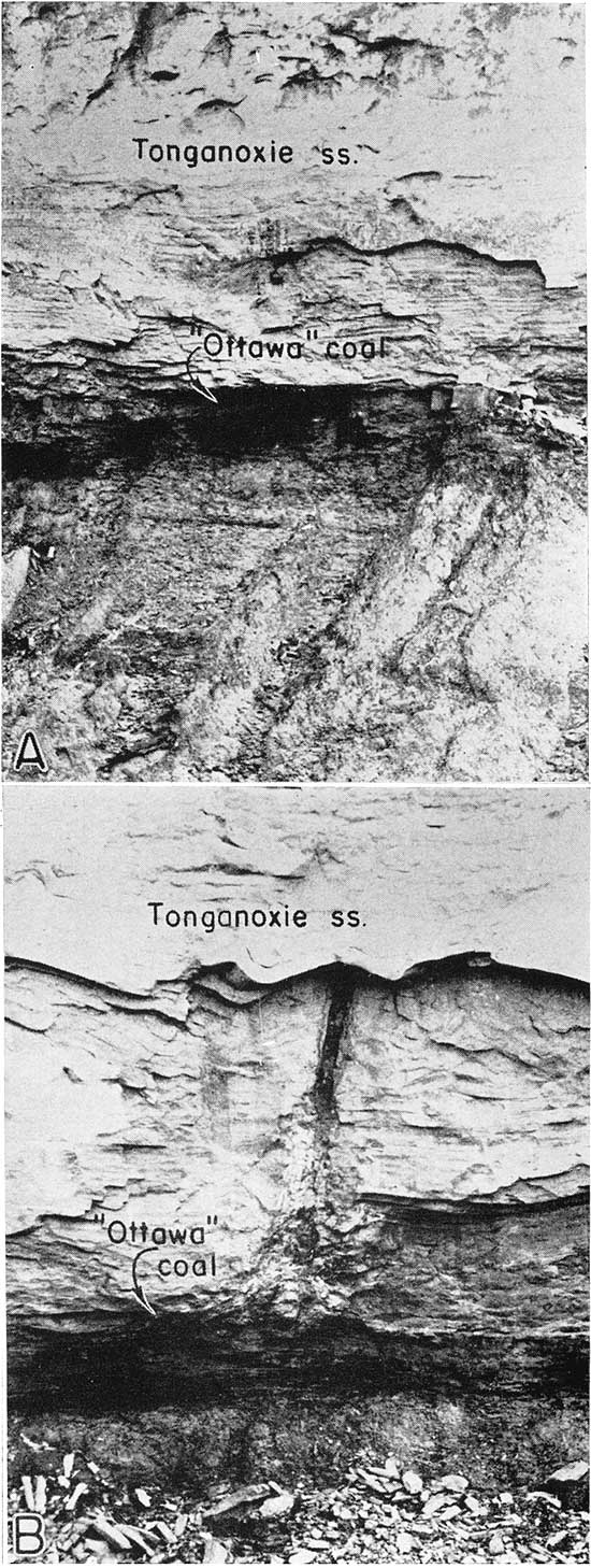
Stratigraphic Relationships--A coal bed is present near the base of the Stranger formation in the escarpments formed by the Tonganoxie sandstone southwest of Ottawa in Franklin County. The zone in which this coal bed occurs lies just above the basal Douglas conglomeratic zone and is characterized throughout most of its exposure by the occurrence of coal beds ranging from 3 to 12 inches in thickness and of very local extent. This coal bed near Ottawa lies in a similar stratigraphic position with the Blue Mound coal, but the lenticular nature of coal beds in this zone suggests that these beds are not continuous with one another or with coal beds in similar stratigraphic positions in other areas. In several instances coal beds are absent from this basal part of the Tonganoxie sandstone. Other writers have considered these coal beds detrital or reworked before final deposition (Moore, 1936, p. 148). Therefore, because of the nature of these coal beds, it is expedient to designate by the informal name "Ottawa" coal bed the coal bed which is well exposed in the road cut along highway 50 S., in SW sec. 14, T. 15 S., R. 19 E., Franklin County (pl. 4). This coal is underlain by a clay shale and overlain by the Tonganoxie sandstone. At this outcrop it ranges from 3 to 6 inches in thickness. The "Ottawa" coal bed, where observed, is thin, but locally it may be more than 8 inches thick. It is exposed in the Tonganoxie sandstone escarpment southwest and west of Ottawa, Franklin County.
Quality--The "Ottawa" coal bed is a relatively soft, thin-bedded bituminous coal which apparently contains a variable amount of ash. The ash consists in large part of interbedded clay shale and disseminated clay particles.
Table 2 contains the results of analyses of two samples from the "Ottawa" bed. Sample No. 1 was collected from a road outcrop on the northwest side of the hill in cen. S. line SW SE SW sec. 9, T. 17 S., R. 19 E. The coal bed at this place consisted of an upper part, of 4 to 5 inches of blocky but thin-bedded soft bituminous coal and a lower part of 3 to 4 inches of interbedded bituminous coal and light gray clay shale. The bed is weathered rather badly. Sample No. 2 was collected from the south road crop on highway 50 S. at the type locality of the "Ottawa" coal bed, SE sec. 15, T. 17 S., R. 19 E., Franklin County (pl. 4A). The bed where sampled was fresh and unweathered. Attention is called to the relatively high percentage of fixed carbon, to the low percentage of ash, and to the rather high heating value.
Table 2. Analyses of the "Ottawa" coal. (Analyses by R. F. Thompson, in the Geological Survey laboratories)
| Sample No. |
Location | Moisture (percent) |
Volatile matter (percent) |
Fixed carbon (percent) |
Ash (percent) |
Heating value (B. T. U.'s per pound) |
|---|---|---|---|---|---|---|
| 1 | Cen. S. line SW SE SW sec. 9, T. 17 S., R. 19 E., Franklin County |
13.81 | 30.46 | 63.5 | 6.04 | 13,900 |
| 13.90 | 30.55 | 63.3 | 6.15 | |||
| 2 | SE sec. 15 T. 17 S., R. 19 E., Franklin County |
9.95 | 32.6 | 60.4 | 7.00 | 12,300 |
| 9.95 | 32.8 | 59.5 | 7.70 |
Mining History--So far as we have been able to determine, the "Ottawa" coal bed has been mined at only one place. This is a mine on the Scribner farm in NW SW NW sec. 15, T. 17 S., R. 19 E. This was opened by an experienced miner who lived on the farm. The exact date of mining is not known, but it was some time between 1902 and 1922. The entry was short, 30 to 50 feet in length, and only about one-fourth of a ton of coal was removed. Because the coal was mined near the weathered edge of the outcropping coal bed, it was of poor quality.
Reserves and Accessibility--The reserves of the "Ottawa" coal bed are rather large, but, it has not been determined that the bed at any place is thick enough to make mining operations profitable under ordinary economic conditions. However, this coal underlies a comparatively large area of low rolling country southwest of Ottawa; in View of the known characteristics of coal beds in the same general stratigraphic zone, it is reasonable to suspect that there are local areas of considerable increase in thickness. Except in places where it may have a thickness of approximately 12 or more inches, this coal bed will not be mined easily by shaft, or drift methods because it is directly overlain by a thick sandstone. In some parts of the area the sandstone probably protects the coal from weathering, so there may be locations southwest of Ottawa in which strip mining might be practical. In any case, controlling factors are the perchance local thickening of the coal bed and absence of thick overburden. Stripping the sandstone above this coal probably would not be difficult or Very expensive.The Lower Sibley Coal Bed
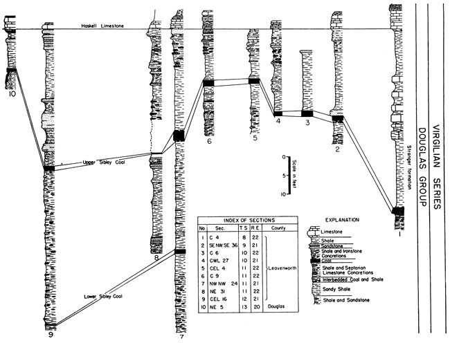
Stratigraphic Relationships--Patterson (1933) assigned the name Sibley coal to the bed occurring next beneath the Haskell limestone member of the Stranger formation and stated that it is well exposed on the hillsides above Sibleyville. In southern Leavenworth County another coal lies approximately 30 feet below the Sibley coal (fig. 9). This lower coal increases in thickness northward from the Kansas river until it becomes 9 to 13 inches thick along the west valley wall of Stranger Creek in T. 11 S. Although it is desirable to distinguish this coal bed from the overlying Sibley coal, it is not expedient to give it a separate name. Therefore, it seems best to refer to the lower coal as the Lower Sibley coal bed, and to the upper one, the Sibley coal bed of Patterson, as the Upper Sibley coal bed. An exposure on the Summers farm might well be chosen as the type outcrop of the Upper and Lower Sibley coal beds. This exposure is on the southeast slope of an escarpment below a barn on the west valley wall of Stranger Creek in NW cor. sec. 24, T. 11 S., R. 21 E., Leavenworth County (fig. 9, sec. 7). At this exposure the Lower Sibley coal bed lies 29 feet below the Upper Sibley coal bed, and 59 feet below the base of the Haskell limestone member.
Figure 9. Correlated outcrop sections of the Sibley coils and adjacent rocks.
A coal bed 1.3 inches thick, lying 37 feet above the Blue Mound coal and 16 feet below the Upper Sibley coal, in the vicinity of Blue Mound, Douglas County, is in the horizon occupied by the Lower Sibley coal bed in Leavenworth County, but we do not believe the two exposures constitute a single continuous coal bed. North from the Summers farm the topography, the character of the rocks, and the vegetation cover obscure the interval in which the Lower Sibley coal bed occurs; therefore, little information was obtained about this bed in central and northern Leavenworth County.
Quality--No analyses were made of the Lower Sibley coal.
Mining History--Some coal may have been taken from the Lower Sibley coal bed on the Summers farm, NW NW sec. 24, T. 11 S., R. 21 E., at the time the Upper Sibley coal was being mined. Small amounts have been mined from this bed in central Leavenworth County.
Reserves and Accessibility--Several instances of crop working and attempted mining of a coal bed at the horizon of the Lower Sibley coal in central Leavenworth County indicate the presence of the coal bed, but supply little information as to reserves, quality, or accessibility.
The Lower Sibley coal lies 59 feet below the Haskell limestone and about 75 feet below the crest of the hill in NW sec. 24, T. 11 S., R. 21 E. This is a rather excessive depth for shaft mining of a thin bed, but such a method would make both coals available for mining in one shaft. At this exposure there is little free moisture in the lower coal, but an appreciable amount of water was observed seeping from the upper coal bed.
On the Summers farm, NW NW sec. 24, T. 11 S., R. 21 E., there are approximately 90 acres underlain by the Lower Sibley coal bed which apparently averages 12 inches in thickness. Assuming that 100 tons of coal can be recovered per acre, per inch of coal bed, there is a reserve of approximately 105,000 tons of bituminous coal in the Lower Sibley bed on the Summers farm. A much greater recovery could be obtained by shaft mining, but 50,000 tons of coal could probably be removed by drift mining methods. These estimates are approximations, including only the reserve of Lower Sibley coal.
We have not made estimates of reserves in other areas because, as far as we know, thicknesses do not warrant mining operations.
The Upper Sibley Coal Bed
Stratigraphic Relationships--The Sibley coal bed was named from exposures along the east valley wall of Cole creek at Sibleyville, in sec. 33, T. 13 S., R. 20 E. (Patterson, 1933). In this area it is approximately 0.2 of an inch in thickness and is the first coal bed below the Haskell limestone. It can be traced southward to the vicinity of Baldwin, but is absent farther south in the vicinity of Ottawa in Franklin County (fig. 9.) We have chosen to designate this coal bed the Upper Sibley coal bed in order to distinguish it from another coal bed which occurs lower and is well exposed in NW sec. 24, T. 11 S., R. 21 E. (fig. 9, sec. 7).
Northward, this coal bed thins somewhat. It ranges from 16 to 20 inches in thickness in sec. 9, T. 11 S., R. 21 E., and from 10 to 18 inches in sec. 5, T. 10 S., R. 22 E. and sec. 36, T. 9 S., R. 21 E. It has a thickness of from 9 to 13 inches at the bridge on Plum creek, cen. sec. 4, T. 8 S., R. 22 E. (pl. 6B and fig. 9, sec. 1). However, there it contains a large amount of interbedded soft bituminous coal and gray clay shale.
Plate 6. A. Shaft mine, NW sec. 9, T. 11 S., R. 22 E., Leavenworth County, Kansas. B. Exposure of Upper Sibley coal near cen. sec. 4, T. 8 S., R. 22 E., Leavenworth County, Kansas (photographs by R. E. Whitla).
The Upper Sibley coal bed is easily located and identified because of its stratigraphic position. In the central part of Leavenworth County it lies 6 to 33 feet below the base of the Haskell limestone. The overlying Vinland shale commonly is characterized by the presence of very dark gray or black, hard, dense, semilithographic, argillaceous septarian limestone concretions. This concretionary zone and the Haskell limestone constitute excellent markers above the coal bed. When a gully is found in which one or the other of these marker beds is exposed, a careful search at the proper interval beneath always reveals the Upper Sibley coal bed. Thus, any search for exposures of the Upper Sibley coal bed can be made rapidly by using these markers as aids in locating possible areas of exposure. The concretionary horizon is remarkably persistent. It has been found from northern Leavenworth County southwest to beyond Homewood in Franklin County. It is, however, not well developed in all exposures (fig. 9).
The Upper Sibley coal is thickest in southern Leavenworth County and thins in all directions.
Quality--The Upper Sibley coal contains a variable amount of ash and fixed carbon. Table 3 gives the results of analyses of samples from the Upper Sibley coal bed.
Table 3. Analyses of the Upper Sibley coal. (Analyses by R. F. Thompson, in the Geological Survey laboratories)
| Sample No. |
Location | Moisture (percent) |
Volatile matter (percent) |
Fixed carbon (percent) |
Ash (percent) |
Heating value (B. T. U.'s per pound) |
|---|---|---|---|---|---|---|
| 3 | Fogel No. 1 mine, Rowen farm, SE SE NW sec. 9, T. 11 S., R. 22 E., Leavenworth County |
3.54 | 30.50 | 50.35 | 19.15 | |
| 3.47 | 31.10 | 50.50 | 18.40 | |||
| 4 | Hyde No. 2 mine, cen. sec. 5, T. 10 S., R. 22 E., Leavenworth County |
2.21 | 41.30 | 48.95 | 9.75 | 12,100 |
| 2.20 | 41.20 | 48.40 | 10.40 | |||
| 5 | Cen. sec. 4, T. 8 S., R. 22 E., Leavenworth County |
2.98 | 32.80 | 43.80 | 23.40 | |
| 3.20 | 33.00 | 44.40 | 22.60 | |||
| 6 | NE sec. 5, T. 13 S., R. 20 E., Douglas County |
21.56 | 24.37 | 28.93 | 46.70 | |
| 21.57 | 24.27 | 28.88 | 46.85 |
Sample No. 3 came from the Fogel mine on the Rowen farm (pl. 6), 6 miles east of Tonganoxie and half a mile north of U. S. Highway 40. The analysis was made of a split of a 10-pound sample which Mr. John Rowen had obtained from the mine operated on his farm by Mr. Walter Fogel in the winter of 1940. (Whitla, 1940, p. 45). This 10-pound sample had been hanging in a burlap sack from a rafter in Mr. Rowen's feed bin all this time. We obtained about 2 pounds of it in order that it might be analyzed. The mine has not been operated for two years, so this was the only sample obtained.
Sample 4 was collected also two years before we obtained it. Mr. Hyde had obtained a 5-pound sample of the Upper Sibley coal bed from two miners who opened a drift in 1940 on his farm, in cen. sec. 5, T. 10 S., R. 22 E. The sample was kept in a burlap sack from 1940 until July, 1942. This sample was taken 30 feet from the mouth of the main entry of Hyde No. 2 mine and may have been subjected to a slight amount of weathering.
Sample No. 5 was collected from an outcrop, just below the bridge across Plum Creek, in cen. sec. 4, T. 8 S., R. 22 E., Leavenworth County (pl. 6B and fig. 9, sec. 1). The outcrop is exposed to weathering and is below the high-water level of Plum Creek, so the coal may be greatly altered. Iron in the ground water has reacted with sulphur in the coal bed forming large nodules of iron pyrites in the coal bed at this exposure.
Sample No. 6 was taken from an exposure on east 15th Street, Lawrence, Kansas, near the type section of the Haskell limestone. This exposure has not been subjected to extreme or long weathering, but such as it has undergone may have caused some alteration in the composition of the Upper Sibley coal bed.
Mining History--Shortly after the establishment of the military post at Leavenworth in 1836, coal mined from the Upper Sibley coal bed along Salt creek in Leavenworth County was used by the post blacksmith in his forge. Mines furnishing this coal were still operating in 1854. Crop mining of the Upper Sibley coal bed was intermittently carried on along Salt creek until about 40 years ago.
These coal mines were probably the first in Kansas. In 1861 a coal bed, the Upper Sibley coal bed, was worked along Little Stranger creek, about 5 miles west of Lansing (Haworth and Crane, 1898, p. 18S). Likewise, Hinds and Greene (1917, p. 11) mention that 10,000 tons of coal were mined in lS67 from a bed exposed along Little Stranger creek below Boling, not far from the southeast corner of the Leavenworth quadrangle. Whitla (1940, p. 12) stated that mining at these two places was abandoned after a few years, although occasionally someone starts a drift or puts down a slope in the area to obtain coal for his own use or for sale to persons living near by. Mining recorded by Hinds and Greene and Haworth on Little Stranger creek is thought to have been on the Hyde farm in SW NW SE sec. 5, T. 10 S., R. 22 E., although information obtained from a grandson dates the mining by the first Hyde as approximately 40 years ago. It was estimated that the mine tunnels and rooms were extended beneath 9 or 10 acres. Assuming that 30 to 40 percent of the coal was removed, there were 3,500 to 4,500 tons of coal recovered from this mine. In the fall and winter of 1940 a drift mine was operated by two miners on the Hyde farm in the center of sec. 5, T. 10 S., R. 22 E. This mining venture failed because there was not financial backing to support preliminary operations. Only a few hundred tons of coal were recovered from this Hyde No. 2 mine before it was abandoned.
An exposure of the Upper Sibley coal bed in a creek on the Kame farm in SW SE sec. 29, T. 7 S., R. 22 E. furnishes farmers near by with some fuel for home consumption during the winter months. The coal is about 9 inches thick, and of that only 4 or 5 inches is suitable for use as fuel. This exposure does not constitute a significant source because the amount available is small. The coal lies along the bottom of a deep creek or gully. Farmers have been taking coal for their own use from the outcrop of the Upper Sibley coal on Plum creek, cen. sec. 4, T. 8 S., R. 22 E., north of Leavenworth, during recent winters. This latter exposure furnishes coal for many near-by farmers, even though the portion of coal suitable as fuel is thin and contains a large amount of iron pyrites.
Examination of the valley wall along the west side of Stranger creek from T. 8 S. to T. 11 S. did not reveal many good exposures of the Upper Sibley coal bed because of the physiographic character of the terrain and the heavy cover of vegetation. There is not much mining through the area. Exposures encourage mining; lack of exposures where there is no geologic guidance retards mining.
The Upper Sibley coal bed lies only about 7 or 10 feet below the base of the Haskell limestone member in outliers east of Stranger creek. One such outlier, lying just to the north of U. S. Highway 40, in E2 SW sec. 7, T. 11 S., R. 22 E., approximately 5 miles east of Tonganoxie, has been the site of intermittent mining for many years. During the winters of 1917 through 1922, "gophering" was employed on the west side of this outlier. Most of the coal was used locally, but some of it was hauled as far as Tonganoxie, Boling, and Leavenworth. The most recent attempt to mine this coal came about two years ago. A slope was dug during the 1939-40 winter, but only a very small amount of coal was recovered. There are three old drift mines on the west slope of this hill.
The most extensive mining of post-Cherokee coal in Leavenworth County in recent years has been in sec. 9, T. 11 S., R. 22 E. Here more than 140 acres are underlain by the Upper Sibley coal. There were several drift mines, and mining has been rather extensive. There were intermittent attempts at mining in this area until about 1939, at which time there arose considerable interest in the coal. The first of the recent mines was dug on the John Rowen farm about 8 years ago, in the SE NE of sec. 8, T. 11 S., R. 22 E. This mine did not continue in operation because the shaft was sunk too near the weathered edge of the coal bed. Strip operations about 50 to 70 feet north of this first shaft probably proved unsuccessful for the same reason. In 1939 a slope mine was opened on the west side of the outlier on the Cook farm, in NW NW SW sec. 9, T. 11 S., R. 22 E. About 50 to 100 tons of coal were removed from this mine before it became filled with water. During a rain the water level rose in a near-by gully and flowed into the entry. After this incident, operations ceased in the mine, but 140 feet of track were left in the entry. A shaft mine was dug in recent years to a depth of 17 feet on the Richardson farm, south of U. S. Highway 40, in NW NE sec. 16, T. 11 S., R. 22 E. This mine, located outside the area protected by the overlying Haskell limestone, was operated for only a short time, probably because the coal bed at that place is badly weathered. The tipple of this mine is still standing. A shaft sunk to 34 feet by Mr. Elliot in 1940 in SW SW sec. 9, T. 11 S., R. 22 E., reached the coal bed but the project was abandoned. No coal was recovered from this shaft, which has since caved in. The last mining venture in the area was on the John Rowen farm. Walter Fogel dug a shaft 42 feet to the Upper Sibley coal bed in SE NW sec. 9, T. 11 S., R. 22 E. A tipple was erected and a gasoline engine used to operate the hoist (pl. 6A). At first the coal was mined by hand (Whitla, 1940, p. 45), but later an electric mining machine was taken into the mine. The coal was sold for $3.50 per ton at the mine. This mine was abandoned in the spring of 1940 and has not been operated since. The shaft walls have fallen in and the buildings, though they still stand, have settled.
Coal was extensively mined from escarpments along the south side of the Summers farm in NW cor. sec. 24, T. 11 S., R. 21 E. (fig. 9, sec. 7), about 40 years ago. At that time three miners were operating two drift mines in the Upper Sibley coal bed. A small hill on the south side of the farm was extensively undermined. There have been several other drift mines dug in this area.
We have found no evidence of mining in the Upper Sibley coal bed south of the Summers farm. South of Kansas river the coal bed is only 0.2 of an inch thick and southward it thins to nothing. The Upper Sibley coal bed has not been mined at Sibleyville, where it is only 0.2 of an inch thick.
Reserves and Accessibility--The thinness and quality of the Upper Sibley coal bed in the area north and west of Leavenworth suggest that there is only a limited amount of coal available to consumers there, and that it is of small economic importance. The Upper Sibley coal bed is overlain by about 20 feet of clay shale which effectively protects the coal bed from weathering. The Haskell limestone has been removed by erosion from about 5 acres in the bottom of Little Stranger creek valley, E2 NW SW sec. 6, T. 10 S., R. 22 E. Here, the Vinland shale ranges in thickness from a few inches to 17 or 18 feet. Because of its texture and composition, the overburden has preserved the quality of the coal. In this area there are approximately 7,000 tons of coal available for strip mining. Much of the area has a layer of thin rock covering the coal bed. Drift mining would be possible, although little can be said about the advisability of drift or shaft mining in this area. The coal bed here seems to be subject to rather rapid changes in thickness.
There were several places between the Hyde farm and the Rowen farm where exposures of the Upper Sibley coal bed were found. At one exposure, about one mile northeast of the Rowen farm, NW cor. sec. 4, T. 11 S., R. 22 E. (fig. 9, sec. 5), the coal seems of Sufficient thickness and quality to justify investigation, should mining be contemplated for this area.
There are two important areas of reserve in Leavenworth County. One of these lies in sec. 9, T. 11 S., R. 22 E. (fig. 9, sec. 6). Approximately 140 acres are underlain by the coal bed, which averages 18 inches in thickness. Assuming a recovery of 100 tons of coal per acre per inch in thickness of the bed, there is a potential reserve of approximately 250,000 tons of coal. If the areas to the south and north of this outlier were investigated, the reserve would undoubtedly be greatly expanded. In this area the Haskell limestone member lies 7 feet above the coal bed, thereby protecting the coal from weathering processes. Erosion has caused the outcropping edge of the limestone to be eroded farther back on the hillsides than the edge of the coal bed. This exposes to weathering an area 50 feet or more wide along the coal bed. Weathering of the coal results in its breaking down to a powder. Therefore, a mine tunnel or shaft dug beyond the periphery of the limestone cap rock will encounter badly weathered coal. Consequently, the condition of the coal bed at that point will be of much poorer quality than that farther within the hill. It should be kept in mind that in this area good coal will not be found until the mine rooms have been pushed into the hillside to such a depth that they lie under the limestone caprock. The outlier just north of U. S. Highway 40, in E2 SW sec. 7, T. 11 S., R. 22 E., does not represent a reserve because the overlying limestone is badly broken and has not protected the coal except under a small area in the central part of the hill.
The second important area of coal reserves lies in NW sec. 24, SW sec. 13, and W2, sec. 14, T. 11 S., R. 21 E., along the west valley wall of Stranger Creek. A small part of this territory was extensively mined and exhausted about 40 years ago. It lies in a small hill at the southeast edge of the escarpment on the Summers farm. However, there have been only one or two drifts dug into escarpments and hills to the north of this small outlier. There is an estimated reserve of 216,000 tons in the hills to the north of this mined-out space, and it is possible that the reserve may be much greater. There is an estimated 90 acres of mining area. Drift and slope mining would probably be most suitable here, but shaft mining could easily be used. The Upper Sibley coal bed lies 30 feet beneath the Haskell limestone. If both Upper and Lower Sibley coal beds are to be mined, shaft mining would be the best method because both coal beds could be mined from one main shaft. The reserve we have estimated applies to the Upper Sibley coal bed only. The estimated reserve for both beds in this area is approximately 266,000 tons of coal.
We could find no information indicating that there has been mining of this coal south of the Summers farm. Probably some drifts have been dug. Southward, in the vicinity of Kansas river, the coal bed is too thin for mining. The Upper Sibley bed is only 0.2 of an inch thick in the Blue Mound and Sibleyville area, and it has not been mined there. It will be recalled that Patterson (1933) chose Sibleyville in Douglas County as the type locality of the Sibley coal bed.
The Lower Williamsburg Coal Bed
Stratigraphic Relationships--In western and northwestern Franklin County a coal bed occurs below the bed known as the Williamsburg coal (Whitla, 1940, p. 21), which was formerly called the Ransomville coal (Moore, 1929, pp. 5, 7). This lower bed lies in the Lawrence shale 20 to 55 feet below the Oread limestone formation. This lower coal bed is here designated as the Lower Williamsburg coal bed and the higher one, called Williamsburg by Whitla, is designated as the Upper Williamsburg coal. The Lower Williamsburg coal bed is well exposed along the highway, near a bridge 1 1/2 miles north of Pomona, 100 yards south of the NW cor. sec. 29, T. 16 S., R. 18 E. (pl. 1B). The Upper Williamsburg coal bed was not observed there when we visited the area. North of Pomona, in Franklin County, the Lower Williamsburg coal bed lies approximately 30 feet below the base of the Oread limestone. This interval thins to about 30 feet in western Douglas County along Wakarusa creek, where the coal bed has been mined. In the vicinity of Lone Star Lake, about 15 miles southwest of Lawrence, there are 6 inches of coal overlain by 14 inches of black carbonaceous shale containing thin streaks of coal. Whitla (1940, p. 21) correlated this coal bed with the Williamsburg; we believe this coal bed to be correlative with the Lower Williamsburg coal because the two, as well as can be determined, lie in the same stratigraphic position. In this exposure the characters of the overlying sediments are similar to those above the Lower Williamsburg coal bed elsewhere, and the coal itself has the same shaly structure and clay shale content as has the Lower Williamsburg coal bed. In exposures along Deer creek, west of Lawrence, this coal bed lies from 20 to 30 feet beneath the Toronto limestone member of the Oread formation. The Lower Williamsburg coal is absent south of the Williamsburg coal field, and it is not found at outcrops in Anderson County. Exposures of this coal bed are rare in Douglas County; none are represented in figure 10.
Figure 10. Correlated outcrop sections of the Williamsburg coals and adjacent rocks. A larger version of this figure is available.
Quality--The Lower Williamsburg coal is commonly a shaly bituminous coal with many thin clay shale partings. It seemingly is developed into a fair quality coal in western Douglas County, where it has been mined along Wakarusa and Deer creeks. Table 4 gives the results of an analysis of a sample of Lower Williamsburg coal bed.
Table 4. Analysis of the Lower Williamsburg coal. (Analyses by R. F. Thompson, in the Geological Survey laboratories)
| Sample No. |
Location | Moisture (percent) |
Volatile matter (percent) |
Fixed carbon (percent) |
Ash (percent) |
|---|---|---|---|---|---|
| 7 | 100 yards S of NE cor. sec. 29, T. 16 S., R. 18 E., Franklin County |
6.41 | 38.90 | 39.50 | 21.60 |
| 6.47 | 40.50 | 38.50 | 20.80 |
Sample No. 7 is a combination of two samples collected at different times from along a road cut near the bridge, 100 yards south of the NW cor. sec. 29, T. 16 S., R. 18 E., Franklin County, Kansas. This is a fresh road cut, and the coal bed has been well protected from weathering. This coal bed is commonly very shaly and possibly contains a rather large percent-age of interbedded clay. The heating value of the Lower Williamsburg coal was not determined.
Mining History--Haworth (Haworth and Crane, 1898, p. 128) Stated that coal mined along Deer creek west of Lawrence was placed on the Lawrence market during the winter of 1897-98. This coal was mined from the Lower Williamsburg coal bed. The mining mentioned above was probably "crop-working" in the bed of Deer creek on the Wulfkuhle farm, in SE SE NW sec. 8, T. 13 S., R. 18 E. The Peterson mine in SW NW sec. 11, T. 13 S., R. 18 E., the Ray mine on the Hauser place in cen. NE sec. 14, T. 13 S., R. 18 E., and the Johnston mine in NE SE sec. 14, T. 13 S., R. 18 E. were opened during the year 1890. The Ray mine operated for about 8 or 9 years, but the others were rather short-lived. The Peterson mine was a shaft mine, but the coal was not of good quality so mining was discontinued. These mines primarily furnished fuel for local use, but some coal was sold in Lawrence. In 1900 a drift mine was opened and operated for several months on the Singer farm in SW NW sec. 8, T. 13 S., R. 18 E. At about the same time a strip mine was opened along Deer creek on the Wulfkuhle farm, where three or four miners worked with horses. Stripping operations caused excessive gullying in the bottom land of farms in Deer creek and lowered the water table in the immediate vicinity of the mining. Because of these undesirable results, mining was discontinued. A shaft mine and a drift mine were operated in SW SW NW sec. 8, T. 13 S., R. 18 E. for several years. The coal was sold at the mines to neighbors and occasionally to buyers from Lawrence and other towns not far distant.
Mines were opened on the Hatcher farm, SE NW SE sec. 7, T. 14 S., R. 18 E., and the Rayber farm, NE NE SE sec. 6, T. 14 S., R. 18 E., and were operated only during the winter of 1907. The last mining in this area was on the Clough and Steel farm, SW SE sec. 12, T. 13 S., R. 18 E.
Several attempts have been made to mine the Lower Williamsburg coal in western Franklin County. Although locally it is rather thick, all ventures have been unprofitable because of the poor quality of coal there.
Reserves and Accessibility--Because the coal, where it is exposed, is of low quality, and because of lack of outcrops and mines along most of the line of outcrop, no estimates of the reserves of the Lower Williamsburg coal are made.
The Upper Williamsburg Coal Bed
Stratigraphic Relationships--Mining in the Williamsburg mining district began at Ransomville many years ago when Mr. Ransom dug a shaft mine to a coal bed; it was later known as the Ransomville and still later as the Williamsburg coal bed. In the present report this bed is designated the Upper Williamsburg coal. In the Williamsburg mining district the Upper Williamsburg coal attains a thickness ranging from 18 to 22 inches. An exposure along U. S. Highway 50 S., one-half mile southwest of Williamsburg (fig. 10, sec. 8), reveals the stratigraphic position of the Upper Williamsburg coal bed. Here it lies directly above a limestone tentatively correlated with the Amazonia (Moore, 1936, p. 157) and 32 feet below the base of the Toronto limestone member of the Oread formation. Southward through Anderson, Coffey, and Woodson counties the interval between the Toronto limestone and the Amazonia (?) limestone (fig. 8) remains fairly constant. A clay seam occurs here and there in the coal bed north of sec. 30, T. 17 S., R. 18 E., lowering the quality of the coal and causing increasing mining expenses. The greatest thickness of the Upper Williamsburg coal bed is on the Robbins farm, E2 sec. 16, T. 16 S., R. 18 E., where it is 24 to 26 inches thick. There the central portion consists of a 3- to 4-inch clay shale seam. The coal bed thins northward from the Robbins farm; it is only a fraction of an inch thick and lies about 12 feet below the Toronto limestone where exposed in NW SW sec. 29, T. 15 S., R. 18 E. (fig. 10, sec. 1).
We are of the opinion that the coal bed which is 8 inches thick in the vicinity of Lone Star Lake in Douglas County (Whitla, 1940, p. 21), and which lies above the Lower Williamsburg coal bed and 10 feet below the Toronto limestone member, is possibly the Upper Williamsburg coal. However, we have not correlated from exposure to exposure the many other thin coal beds developed in the Lawrence shale in northern Douglas and Leavenworth counties.
The Upper Williamsburg coal thins southward and westward from the Williamsburg coal mining district. At an exposure in NE sec. 24, T. 19 S., R. 17 E., (fig. 10, sec. 10) Anderson County, the coal bed lies 7 feet above the Amazonia (?) limestone, and 17 feet below the Toronto limestone, and is 12 inches thick. Southward into Woodson County the coal bed rises stratigraphically and lies immediately beneath the base of the Toronto limestone (pls. 2A, 3B and fig. 8). Westward from the Williamsburg mining district into the Quenemo mining district, Franklin County, the stratigraphic relationships are similar. At an exposure 3 miles south of Quenemo the coal bed immediately beneath the Toronto limestone member is correlated with the Upper Williamsburg coal bed.
Quality--The Upper Williamsburg coal bed is composed of a relatively hard, massive but thinly-bedded, bituminous coal which is of variable clay content and may become rather shaly in places. Table 5 presents the results of analyses of samples collected from the Upper Williamsburg coal bed.
Table 5. Analyses of the Upper Williamsburg coal. (Analyses by R. F. Thompson, in the Geological Survey laboratories)
| Sample No. |
Location | Moisture (percent) |
Volatile matter (percent) |
Fixed carbon (percent) |
Ash (percent) |
Heating value (B. T. U.'s per pound) |
|---|---|---|---|---|---|---|
| 8 | NW SE sec. 4, T. 18 S., R. 18 E., Franklin County |
2.39 | 32.10 | 62.80 | 4.10 | 13,700 |
| 2.42 | 32.30 | 62.70 | 5.00 | |||
| 9 | Mine face, Fogel mine SW SE SE sec. 5, T. 18 S., R. 18 E., Franklin County |
16.25 | 27.01 | 55.90 | 17.90 | |
| 16.20 | 27.15 | 55.05 | 17.80 | |||
| 10 | Tipple, Fogel mine SW SE SE sec. 5, T. 18 S., R. 18 E., Franklin County |
2.08 | 35.60 | 57.45 | 6.95 | 13,500 |
| 2.13 | 35.60 | 57.25 | 7.15 | |||
| 11 | Tipple, Couch mine cen. NW sec. 8, T. 18 S., R. 18 E., Franklin County |
2.64 | 38.10 | 49.90 | 12.00 | |
| 2.70 | 37.50 | 49.70 | 12.80 |
In 1889 Lucien I. Blake (1889, pp. 48-49) published the results of several coal analyses. His analysis of coal from Franklin County (very probably the Upper Williamsburg coal) is given in table 6.
Table 6. Analysis of Williamsburg coal made by L. I. Blake in 1888.
| Moisture (percent) |
Volatile and combustible matter (percent) |
Fixed carbon (percent) |
Ash (percent) |
|---|---|---|---|
| 7.55 | 44.40 | 37.68 | 10.37 |
Although Blake did not give data as to the heat value of the coal, the high percentage of fixed carbon and volatile matter indicate, by comparison with other analyses of coal samples, that the heat rating should be the order of 11,000-13,000 B. T. U.'s.
In an effort to compare the Williamsburg coal with other coals sold by them, the North Ottawa Lumber Company sent one sample from the Couch No. 1 mine at Williamsburg to the Commercial Testing and Engineering Company, Chicago, Illinois, and another set of three samples from the Couch and two other near-by mines to the Pittsburg-Midway Coal Mining Company, Pittsburg, Kansas, for analyses. The results are shown in the analyses below.
Table 7. Analyses of the Upper Williamsburg coal; analysis of sample from Couch No. 1 mine. (Analyses made by Commercial Testing and Engineering Company, Chicago, Illinois)
| Condition | Moisture (percent) |
Ash (percent) |
Volatile matter (percent) |
Fixed carbon (percent) |
Sulphur | Heating value (B. T. U.'s per pound) |
|---|---|---|---|---|---|---|
| As received | 16.79 | 8.50 | 34.76 | 39.95 | 0.96 | 10,694 |
| Dry | 10.22 | 41.77 | 48.01 | 1.15 | 12,858 |
Table 8. Analyses of the Upper Williamsburg coal, by Pittsburg-Midway Coal Mining Company.
| Mine | Moisture (percent) |
Ash (percent) |
Volatile matter (percent) |
Fixed carbon (percent) |
Sulphur (percent) |
Heating value (B. T. U.'s per pound) |
|---|---|---|---|---|---|---|
| Couch | 16.79 | 8.50 | 34.76 | 39.95 | 0.95 | 10,699 |
| 12.93 | 9.26 | 34.92 | 42.89 | 1.32 | 10,933 | |
| Parkin | 10.64 | 40.10 | 49.26 | 1.52 | 12,556 | |
| 10.73 | 10.03 | 37.58 | 41.66 | 2.01 | 11,229 | |
| Thornburgh | 11.24 | 42.10 | 46.66 | 2.25 | 12,579 |
Mining History--Franklin County--An area approximately 5 miles northeast of Pomona has been extensively but intermittently mined for many years. Most of these mines are located on the Robbins farm, in E2 sec. 16, T. 16 S., R. 18 E. Mining was most extensive about 40 years ago. At that time, and for nearly a decade thereafter, the area was the site of very thoroughly "gophered" mines. These operations have almost depleted the reserve of coal available near the outcrop. It is difficult to determine the location of these old "gopher" holes. A drift mine, dug along cen. N. line NE sec. 16, T. 16 S., R. 18 E., encountered two or three old entries. Of course the coal on either side of these old entries has been removed. This mine, which was operated during the winter of 1941, was extended a distance of more than 200 feet into the hillside. The Upper Williamsburg coal bed is 24 to 26 inches thick here, but it has a rather thick medial clay parting. No data on production from this mine were obtained. Possibly 1,000 tons of coal have been taken from these drift mines during the last 10 years.
Bowsher investigated a strip pit on the Robbins farm in NE NE SE sec. 16, T. 16 S., R. 18 E., which had been operated some time in the early 1930's. Approximately an acre of coal has been recovered by the use of a shovel, and the mine is said to have been operated by two, three, or four men. An estimated 1,500 tons of coal were taken from this strip pit. It is now filled with water.
In the winter of 1932-33 one wagon load of coal was taken from an outcrop of the Upper Williamsburg coal on the Usher farm, at the northeast foot of "Rattlesnake Mountain" near the Franklin-Osage county line, west of Pomona, in NE SE secs. 3-5, T. 16 S., R. 17 E. The coal bed there is 6 inches thick.
An area 2 1/2 miles southwest of Pomona, in secs. 14, 24, and adjoining sections in T. 17 S., R. 17 E., has been heavily mined in the past, but it has been mined only occasionally during late years. No exact information about this early mining was obtained. Several drifts were started in this area in the early part of the 1930's, but little information about them is available. During the years 1933 to 1936 the Bush Coal Company operated a drift in cen. S line NE sec. 14, T. 17 S., R. 17 E. This mine furnished employment for 17 to 22 men and ran continuously for three years. In this mine the Upper Williamsburg coal bed lies 9 feet below the Toronto limestone, which furnished a good roof. The coal bed is 17 inches thick there. The mine underlies less than two acres. From this it is estimated that less than 1,500 tons were produced from the mine. The mines in this area closed at the time when it became increasingly difficult to employ miners. During the winter of 1941 an attempt was made to reopen the mine, but production did not support costs of mining. The small size of the mining crew--two men--probably accounted for the unprofitable operation.
Mining has been carried on in the vicinity of Williamsburg, Franklin County, for many years. Most of the early mines were "gopher holes," but some statistical data about them are available. The following paragraphs on mining in this area are written from information gathered by Mr. Bowsher while talking with people now living in the neighborhood.
A drift mine was operated for about one month in 1937 on the Tabbert farm in SE SE SE sec. 24, T. 18 S., R. 17 E. Two miners drove an entry nearly 200 feet, and about 30 tons of coal were recovered from the Upper Williamsburg coal bed. Another drift mine was opened in 1940 near the center of N2 sec. 25, T. 28 S., R. 17 E. Two miners recovered about 20 tons of coal from along a 200 foot entry. This tunnel and its air shaft are now in good condition. The Amazonia (?) limestone serves as a floor in this mine (fig. 10), and the roof consists of 30 feet of clay shale. Some drift and strip mining was done in 1937 on the Price farm, secs. 26 and 35, T. 18 S., R. 17 E. A drift mine was opened on this farm in N2 SE NE sec. 26, in 1938, and the mine was operated intermittently for nearly 3 years. The entry has been driven a distance of nearly 200 feet along the Upper Williamsburg coal bed which is between 12 and 18 inches thick there. The production from this mine is estimated to have been approximately 30 tons of coal each month.
A strip mine was opened in January of 1937 on the Hale farm, SE NE sec. 13, T. 18 S., R. 17 E. A steam shovel was used and 12 to 14 men were employed. The Upper Williamsburg coal bed, which averages 12 inches in thickness, but is found to be locally only 6 inches thick, in most places lies directly on the Amazonia(?) limestone but is in places separated by 6 or 7 inches of gray clay. In some places as much as 14 to 18 feet of overburden were removed. An estimated 1,800 tons of coal were recovered before operations ceased the following December.
A drift mine was opened and operated during the winter of 1939 on the Goodwill farm, SW SW NW sec. 18, T. 18 S., R. 17 E. The entry was driven 200 feet along the 12 to 14 inch Upper Williamsburg coal bed by two miners, who recovered 60 to 80 tons of coal. The mine was not reopened the following winter because the main entry, a slope, had become filled with water.
During the winter of 1939, some 700 tons of coal were recovered from the Upper Williamsburg coal bed on the Duval farm, NW SW sec. 15, T. 18 S., R. 18 E., in a small strip mine underlying an area of nearly half an acre. At the same time, a shaft mine was sunk on this farm in NW NW NW sec. 8, T. 18 S., R. 18 E. The shaft was sunk 30 feet to the Upper Williamsburg coal bed which was found to be 12 to 14 inches thick. Seven or eight miners were employed there during the winters of 1939 and 1940. Nearly 1,300 tons of coal were recovered before the coal available in this mine was exhausted. A sump dug 30 inches below the bottom of the coal bed did not reach the Amazonia (?) limestone.
Six miners are reported to have recovered 80 to 100 tons of coal per day from a drift mine operating on the Blair farm, SE SW sec. 5, T. 18 S., R. 18 E., during the winters of 1939 and 1940. These figures, based on estimated production in bushels, may be slightly too high.
The Couch No. 1 shaft mine, at about the center of W2 SW sec. 8, T. 18 S., R. 18 E., was operated for some time and was closed in about 1937. The shaft was 80 feet deep. Coal was removed from an area of approximately 50 acres, and it is estimated that an amount of coal in excess of 65,000 tons was removed. When the Couch No. 1 was closed, another shaft was sunk. This mine, the Couch No. 2, at about the center of the NW sec. 8, T. 18 S., R. 18 E. (fig. 10, sec. 7), is now operating and is the most active mine in the Williamsburg district. The shaft is 82 feet deep, and the mineable part of the Upper Williamsburg coal averages 16 inches in thickness. The hoist is operated by means of a gasoline engine. The number of miners employed ranges from 7 to 16. Electrically operated undercutting machines are used. The capacity of this mine, when two undercutting machines are used, is said to be 100 tons of coal per day. The circle long wall mining method is employed (fig. 7). In the late summer of 1942 the mine face had been driven 170 feet.
The Walter Fogel mine, SE SE SE sec. 5, T. 18 S., R. 18 E. (fig. 10, sec. 6), was opened in the fall of 1940. The mine hoist is operated by a gasoline engine, and power is supplied to the single undercutting machine by a portable electric generator located at the surface. The shaft is 66 feet in depth, and the coal bed averages 14 inches in thickness. The coal bed lies directly on the Amazonia(?) limestone or is separated from it by a few inches of gray clay. Four to 12 men have been employed, but only 6 were working in the summer of 1942. They are working only the southwest one-fourth of the full circle face because water encroaches on the remainder of the coal face during the rainy season. The coal face is approximately 90 feet from the shaft. It is estimated that not more than 250 tons of coal have been recovered from this mine.
The Parkin mine, cen. E line SW sec. 4, T. 18 S., R. 18 E., is not being operated at present. Mining operations ceased during September of 1942, although the mine was still kept in shape for mining. At that time the Parkin mining crew began operations in a drift mine in SW NW sec. 7, T. 18 S., R. 18 E. The former mine employed 5 to 10 miners. One undercutting machine was being used. The mine normally produced between 29 and 40 tons of coal per day from the Upper Williamsburg coal bed.
A drift mine is being operated by one man on the Hettich farm, NW NW sec. 11, T. 18 S., R. 17 E. This mine, which is located near 4 or 5 old drift mines, was opened in the winter of 1941-42, and has not been driven far into the hillside. There has been only a small amount of coal taken from this mine.
The shaft of St. John's mine, NE cor. sec. 6, T. 18 S., R. 18 E., was dug to a depth of 16 feet. It was operated only during the winter of 1941 when 500 to 800 tons of coal were mined. The Upper Williamsburg coal bed, which was found to be between 17 and 18 inches thick, is a so-called seam coal; that is, it contains a medial clay shale parting which increases mining difficulties and costs.
A drift mine was started in January of 1942 on the Van Walkenberg farm. In the late summer of 1942 there were 500 feet of entryways in the mine. A cross entry had been driven into a near-by shaft which was dug in 1938. Little coal had previously been taken from this old mine, which is at present operated by one miner. At the time of Bowsher's visit in August, 1942, an average of one ton of coal per day was being taken from the mine. The Upper Williamsburg coal bed is 12 inches thick in this mine.
Innumerable old mines exist southeast of Williamsburg. About 50 years ago, strip mines were operated on the Bunn and Widner farms. Approximately 1,900 tons of coal were taken from mines on the Widner farm, NE cor. SW sec. 16, T. 18 S., R. 18 E. About an acre was stripped from the coal bed, which ranges from 18 to 22 inches in thickness. Eight or ten teams of horses were used to remove the overburden. Also, there have been three drift mines on this farm. The first of these was operated during 1916 and 1918, and the last during 1939. These drifts were driven approximately 200 feet into the hillside. At least 60 or 70 tons of coal were taken from the most recent of these mines. About 50 years ago, Upper Williamsburg coal was stripped from an area of less than one acre on the Bunn farm, cen. W. line sec. 21, T. 18 S., R. 18 E. The coal bed there was found to be only 10 inches thick, and no more than 1,200 tons were obtained. A kerf which yielded three wagon loads of coal was removed from the center of the pit in 1941 and the old pit was then converted into a lake. Nearly 40 years ago several wagon loads of coal were removed from a drift mine driven 60 to 70 feet on the Emmett King farm, cen. NE NE sec. 28, T. 18 S., R. 18 E.
An area of almost one-half acre was stripped by two miners on the Welch farm, NE cor. NW sec. 22, T. 18 S., R. 18 E., and approximately 700 tons of coal were recovered. A slope mine was driven 300 or more feet into the hillside on the J. Sheppard farm, SW SE sec. 29, T. 18 S., R. 18 E. Operations began in 1936 and were continued until 1941. Most of the time only two miners were working, but sometimes during the winter there were six. The available part of the coal bed is 12 inches thick, and the entries were driven under about 1 1/2 acres. An estimated 1,400 tons of coal were recovered. At present the slope stands full of water, and is used as a well. The remaining coal undoubtedly has been thoroughly penetrated by water.
Mining History--Osage County--Quenemo District--Osage county is rather well known as a coal-mining area because the Osage City or East-central Kansas coal field is centered there. The Nodaway coal which occurs in the Wabaunsee rocks is mined in Osage county. The Nodaway coal will be discussed in a later report.
In the southeastern part of Osage county the Upper Williamsburg coal lies at a position ranging from 5 to 3 feet below the lower member of the Oread limestone (Toronto limestone), which serves as an excellent mine roof. The floor consists of light gray clay shale. Extensive mining has been carried on for many years in this area which is designated as the Quenemo district. There are several short drifts along the outcrop of the coal bed on the Dean and Yockey farms in sec. 27, T. 17 S., R. 17 E. This situation is typical for the area, and the more important mining ventures are briefly discussed in the following paragraphs.
Forty or more years ago two shafts were operated on the Bryden farm, sec. 27, T. 17 S., R. 17 E. The coal mined there constituted a 15-inch bed. One mine was 50 feet deep; six or eight miners operated the mine. Two or three miners worked in the other mine which was 30 feet deep. A small amount of coal was produced, and the mines are now filled with water.
In the winter of 1939-40, a drift mine was driven to a depth of 100 feet at about the center of N2 SE SE sec. 37, T. 17 S., R. 17 E., and at the same time a shallow shaft was dug near by. The coal bed there ranges from 12 to 14 inches in thickness. A small amount of coal was taken from the mines.
Several short drifts were made into the hillside on the Dawson (Porter) farm SE sec. 22, T. 17 S., R. 17 E. in 1930. No data as to the amount of coal recovered are available to us. Two miners were employed there. In the shafts the coal bed was found to be 12 to 14 inches thick.
A drift mine, cen. W line sec. 27, T. 17 S., R. 17 E., was opened on the Bryden place in 1934. From six to nine miners were employed to mine from the Upper Williamsburg coal bed which there varies from 12 to 14 inches. Prior to the end of 1940 this drift mine had produced 600 to 700 tons of coal per year and had been driven 500 feet into the hillside. It was then abandoned and a second drift mine, in the NW cor. NW SW sec. 27, T. 17 S., R. 17 E., was opened. Only four miners were employed in this mine which is still operating and producing 200 to 300 tons of coal per year.
The Wilson mine, SW SE sec. 22, T. 17 S., R. 17 E., was driven 50 feet into the hillside, but it did not produce any appreciable amount of coal. A shaft mine on the Murrin farm, SW cor. sec. 34, T. 17 S., R. 17 E., was dug 40 feet to the Upper Williamsburg coal bed which was 12 to 14 inches thick. Three or four miners were employed and recovered approximately 100 tons of coal. Because of a problem in disposing of mine waters, the mine was abandoned.
Although the Davison farm also is well "gophered" along the outcrop of the Upper Williamsburg coal bed, a drift mine was dug in the NE cor. sec. 10, T. 18 S., R. 17 E. during the winter of 1940. It is still in operation. The entry has been extended 200 to 300 feet from the mine opening, and mining is done by two miners. The coal bed, composed of very good, hard bituminous coal, is 12 to 14 inches thick.
During the winter of 1939 the Bush Coal Company began stripping operations in cen. S2 SW sec. 25, T. 17 S., R. 17 E., Osage county. Three miners were employed and a steam shovel was used. An area of about 1 1/2 acres along the side of a creek was stripped. The coal mined there is 12 to 14 inches thick. Approximately 1,850 tons of fairly good coal were recovered. Mining was abandoned after the exhaustion of coal available for stripping.
Mining History--Anderson County--The Upper Williamsburg coal is exposed in the northwestern corner of Anderson County. The area of exposure is small and the coal bed is rather thin. However, in the 1880's there were many small drift and strip mines along the escarpments in the western half of secs. 11 and 14, T. 20 S., R. 17 E. The coal bed mined in this county by the farmers for home consumption and for thresher engine fuel ranges from 6 to 9 inches in thickness.
When Bowsher visited the area in northeastern Anderson County there was, according to his observations, only one place in the county where coal was being mined. This was in the form of crop working at an exposure along a creek east of the barn on the Jennings farm, approximately cen. NE sec. 10, T. 20 S., R. 10 E. Each winter coal is taken from this very small outcrop as it is needed at the near-by farmhouse.
Mining History--Coffey County--The Osage City or the East-central Kansas coal district extends into northwestern Coffey County. The coal mined there is the Nodaway coal, a coal bed higher in the stratigraphic section than the Douglas coal beds. Nodaway coal is not discussed in this report.
About 50 years ago coal was obtained from a strip pit along the south side of sec. 29, T. 20 S., R. 17 E., and from mines on the Whitehead farm, NE SW sec. 21, T. 20 S., R. 17 E. On the Whitehead farm, a drift was driven for a distance of about 180 feet into the hillside and a shaft mine was dug 40 feet deep. The coal bed is only 6 inches thick in these mines. The amount of coal recovered was small and was used for home consumption. Ten or more years later a small strip mine was opened on the Bouse farm, in NE NE NE sec. 14, T. 21 S., R. 16 E. At about the same time a drift mine was opened on the Baker farm, NW SW sec. 28, T. 21 S., R. 16 E. The coal from this small mine was used for home consumption.
In 1916 drift and strip mines were operated on the Armstrong farm. The strip mine was located in cen. of S2 of sec. 33, T. 21 S., R. 16 E. The strip pit is slightly in excess of one-fourth of an acre in area. It is possible that 400 tons or less of coal were removed. After too great an amount of overburden was encountered the operators began digging a drift mine from the pit. One or two farmers worked in this mine, and the coal was produced for their own consumption. The coal is from the Upper Williamsburg coal bed.
Mining History--Woodson County--The Upper Williamsburg coal bed ranges in thickness from 5 to 10 inches in Woodson County and lies directly beneath the Toronto limestone (pls. 4A, 5B, and 6B). The coal in this county is not thick nor of exceptionally good quality and, consequently, has not been extensively mined.
Very little information concerning old mines in northern Woodson County was obtained. An old strip pit was operated for some time on the Silsby farm, N2 sec. 28, T. 23 S., R. 15 E. During recent winters farmers have been getting their winter's fuel supply from an exposure of the Upper Williamsburg coal bed in the N2 SW sec. 28, T. 23 S., R. 15 E.
About 25 years ago coal was being mined from strip mines in the NE sec. 35, T. 23 S., R. 15 E., and on the Burney farm, cen. S2 NW sec. 5, T. 26 S., R. 14 E. A strip pit on the Hare farm in E2 NE sec. 32, T. 25 S., R. 14 E. produced about 100 tons of coal in the winter of 1935-36. This strip pit and one on the Corkery farm at the same place and dug in 1934 are now used as ponds.
It is remarkable that coal should be mined in this area by stripping methods. The coal bed ranges from 5 to 10 inches in thickness and is overlain by 5 to 9 feet of limestone. Locally, the coal bed is separated from the limestone by 18 inches of light gray, very tough, thinly but irregularly bedded silt shale. Removing this overburden is a difficult and expensive operation, but the method has been rather extensively practiced.
The Tim strip pit, cen. N line NE sec. 36, T. 25 S., R. 13 E., is the only mine in the area from which coal is obtained at present (pl. 3A). This strip pit is located in a stone quarry on the south side of U. S. Highway 64. The limestone was removed and crushed for use in highway construction. The coal lies 10 inches beneath the floor of the quarry. The farmers have been obtaining coal from this old quarry each of the last few winters. Only 10 inches of overburden covers the coal. There is a reserve of nearly 780 tons in this quarry which is approximately 290 feet by 150 feet in size. Possibly 70 tons had been mined from the quarry by 1942.
Mining History--Greenwood county--West of Toronto on the Petterson farm, cen. sec. 4, T. 26 S., R. 13 E., a shaft mine, dug in 1910, reached the Upper Williamsburg coal bed at a depth of 35 or 40 feet. The mine was closed before production started because an accident inside the mine resulted in the death of two persons.
Reserves and Accessibility--The Upper Williamsburg coal generally is so thin in areas south of Franklin County that drift, slope, and possibly shaft mining hardly seem practical. The Toronto limestone lies directly above the coal and hence stripping is handicapped. Strip mining, however, has in the past been carried on rather extensively in Woodson County. In that county the overburden, including 5 to 9 feet of limestone, was removed. The coal bed is 10 inches or less in thickness. Mr. Bowsher observed one abandoned strip pit, at cen. N line NE sec. 36, T. 25 S., R. 13 E., and he concluded that conditions there are rather exceptional inasmuch as it appears that coal can be recovered at low cost. However, it should be noted that coal ranging from about 9 to 10 inches in thickness is present beneath the Toronto limestone throughout the length of its line of outcrop in Woodson County. At present no mines are operating in Woodson County.
In Coffey County there are probably several locations in or near sec. 33, T. 21 S., R. 16 E. in which the Upper Williamsburg coal can be mined profitably.
In northwestern Anderson County the Upper Williamsburg coal bed is thin, and we know of no places there that should properly be regarded as mining areas.
The Williamsburg mining district, in southwestern Franklin County, T. 18 S., R. 18 E., represents the largest reserve area of the Upper Williamsburg coal bed, the best portion of which seems to lie in sec. 8, T. 18 S., R. 18 E. There the available part of the coal bed averages about 18 inches in thickness (figs. 10, 11, and 12) and it is well protected by the overlying Oread formation. Time allowed only a cursory examination of reserves and mined-out places in the district, so detailed information was not obtained for all of the area. The Couch No. 2 mine is the largest producer, and information was obtained as to reserves available to this mine. This mine, located at approximately cen. NW sec. 8, T. 18 S., R. 18 E., is equipped with modern mining equipment and is operated by trained personnel. The negligible amount of water coming into it can adequately be disposed of, and the mine has a good ventilation system. At present (1942-43) the mining crew is being reduced because of calls for military service. Labor shortage and certain economic conditions are slowly reducing the amount of coal being produced from this and other mines in the area. Although the mine is at present producing only about 20 to 30 tons per day, it has a large coal reserve to the southeast (fig. 12). The 80-acre lease on which this mine is located is nearly half worked out. Approximately 75,500 tons of coal remain under lease by the mining company. At least three-fourths of sec. 8, T. 18 S., R. 18 E., is underlain by a coal bed which averages 18 inches in thickness. A reserve of more than 800,000 tons of coal occurs in this section.
Figure 11. Map of Franklin County, Kansas, showing area and thickness of the Upper Williamsburg coal.
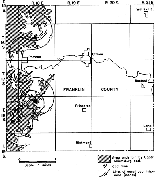
Figure 12. Coal map of Upper Williamsburg deposit in a portion of T. 18 S., R. 18 E., Franklin County, Kansas.
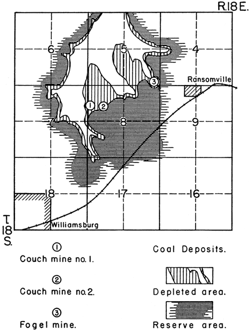
Further estimates of coal reserves have not been made for this area. It can be. said that the greater part of the outcrop area of the Upper Williamsburg coal bed in the Williamsburg and Quenemo mining district has been nearly depleted by years of gophering. Shaft mining has been used in many parts of the district, but many of these mines have been short-lived and have removed only a small part of the available coal. Therefore, it is apparent that a detailed study of mining in these districts would necessitate rather detailed mapping of worked-out and reserve areas. Such information may become extremely valuable in time of acute fuel shortage.
The south half of sec. 14, T. 17 S., R. 17 E., Franklin County, is underlain by the Upper Williamsburg coal bed which there averages 17 inches in thickness. There are 5 to 7 acres in which coal is available for drift mining. This represents a reserve of approximately 12,000 tons of coal. There are about 210 acres in which shaft mining could be profitably employed, a reserve of approximately 350,000 tons. No exposures of coal were seen in this area, but some miners state that the coal there is a "seam" coal; that is to say, it has a medial clay parting.
The western half and part of the eastern half of sec. 16, T. 16 S., R. 18 E., on the Robbins farm, is underlain by the Upper Williamsburg coal bed, averaging 24 inches in thickness but having a medial clay parting. This area has been so extensively mined that estimates of reserves are difficult to make. Very little coal would be available to strip or drift mining methods. However, there are at least 160 acres, underlain by the coal bed, a reserve of approximately 200,000 tons of coal.
There are other areas in which there are reserves of the Upper Williamsburg coal bed. Prospecting of rocks immediately below the Oread limestone might well be done both by examining, outcrops and by core drilling.
Other Coal Beds in the Douglas Group
A thin coal bed, a few inches in thickness, occurs beneath the Amazonia (?) limestone in Coffey County. It is not known whether this coal is anywhere sufficiently thick to allow profitable mining.
In Douglas and Leavenworth counties there are several thin coal beds in the Lawrence shale. They are not only very thin, in general, but also they have small lateral extent. We have not attempted to correlate these beds and do not know of any locations in which any of them are more than a very few inches thick.
Table 9 shows the result of analyses of two additional coal samples from the Lawrence shale. These analyses were made in order to learn something about the character of the thin coals in the Lawrence shale. It is to be noted, however, that the low heating value and high ash content should not be regarded as indicative of thicker coal beds in the same formation. It is noted in this report that coal in the Lawrence shale that appears to be of high quality was seen by Bowsher in Anderson County. Attention is called here, also, to the relatively high quality of the Williamsburg coal as described on previous pages of this report.
Table 9. Analyses of coal from two minor beds in the Lawrence shale. (Analyses by R. F. Thompson, in the Geological Survey laboratories)
| Sample No. |
Location | Moisture (percent) |
Volatile matter (percent) |
Fixed carbon (percent) |
Ash (percent) |
Heating value (B. T. U.'s per pound) |
|---|---|---|---|---|---|---|
| 12 | Coal bed approximately 50 feet below Oread limestone, NW NW NW sec. 16, T. 10 S., R. 21 E., Leavenworth County |
5.35 | 44.20 | 48.45 | 7.25 | 7,890 |
| 5.35 | 44.20 | 48.30 | 7.51 | |||
| 13 | Coal at base of Lawrence shale, 100 yards NW cor. sec. 29, T. 16 S., R. 18 E., Franklin County |
29.08 | 27.50 | 31.50 | 41.00 | |
| 28.80 | 27.90 | 31.10 | 41.00 |
A thin coal bed in the Lawrence shale, lying at a position approximately 28 feet below the Toronto limestone, is exposed in the bluff of Kansas River south of Lakeview in sec. 16, T. 12 S., R. 19 E., Douglas County. Twenty-five or 30 years ago, 20 or 30 tons of coal were mined there. The coal bed may be in the stratigraphic position of the Lower Williamsburg coal. Such correlation, however, is based on supposition.
Bowsher discovered what may prove to be an available coal reserve when he found a coal bed approximately 14 inches thick, near the base of the Ireland sandstone (in the Lawrence shale), exposed on the north side of Cherry Creek, at the approximate center of the W line SE NE sec. 13, T. 21 S., R. 17 E., Anderson County. The coal appears to be of higher quality than any other coal examined in the county. No record of its having been mined is available. The bed is, without doubt, very local in extent but probably constitutes a usable reserve.
Information obtained by Mr. Harold McGee of Oklahoma City while core-drilling in an area about 6 miles north and west of Ottawa, Franklin County, indicates a rather large coal reserve. An area containing approximately 600 acres of land is underlain by a coal bed which varies from 18 to 24 inches in thickness. The over-burden, which consists of shale and sandstone, is about 20 feet thick. This area could be adequately worked by strip mining methods. The figures above indicate a reserve of approximately 1,080,000 tons of coal. The data do not indicate the horizon at which this coal bed occurs, but it is probable that it is the "Ottawa" coal bed. Neither Mr. McGee nor we have observed any near-by exposures of this coal bed.
Summary of Reserves and Possible Developments
In east-central Kansas there are several areas underlain by Douglas coal beds that may constitute local sources of fuel. These are some of the areas to which one must look for coal supplies when the larger coal fields can no longer supply all their present consumers--a situation that might result because of overburdened transportation facilities. It is possible, also, that requirements of the several war plants and decrease in available man-power will bring about a condition in which parts of Kansas will be unable to secure sufficient coal from the more extensive fields.
These coal deposits have been important sources of local fuel in times past. Several factors now are causing production to decline in the areas described in this report. Chief among these are the shortage of mine labor and of mine machinery and curtailment of transportation facilities. The disrepute of some coal from minor sources is recognized, also. Modern processing methods practiced in the larger coal fields no doubt have been a factor in causing many consumers to look with disfavor on "local coal." It must be recognized, however, that these coals are not of extremely low quality.
The Tonganoxie District--Leavenworth County
The Upper Sibley coal bed constitutes an important reserve in the southern Leavenworth County area. More than 466,000 tons of coal are available here, in sec. 24, T. 11 S., R. 21 E. and in sec. 9, T. 11 S., R. 22 E. The coal contained in the Lower Sibley bed in sec. 24, T. 11 S., R. 21 E. represents a reserve of approximately 50,000 tons of coal. Hence, it is estimated that in these two sections there is a coal reserve of more than one-half million tons. Mining could be extended beyond the limits of these sections.
Possible Developments--At present there is no mining in southern Leavenworth County. The retail price of coal produced from this and near-by areas was frozen by government order at the level of March 28, 1941. The cost of production has increased since 1941 and the price of coal at the mine was raised from $3.05 per ton to the ceiling price of $4.05 per ton, as established by the Bituminous Coal Commission in 1937. Because price fixing kept the retail price at the 1941 level, the retail marketer was forced to cease sales of Douglas coal. Therefore, it seems probable that mining will not be resumed on more than a minor scale as long as the present legal and economic conditions exist.
The Blue Mound District--Douglas County
Although it is not advisable to make definite estimates, it is well to note that there is apparently a rather large coal reserve in the Blue Mound coal bed in the Blue Mound area about 6 miles southeast of Lawrence, in Douglas County. Geologic and topographic conditions indicate that mining operations could be carried on rather easily. Well-surfaced roads connect this potential coal field with Lawrence. Under certain economic conditions, coal from this source may be of considerable value.
The Williamsburg District--Franklin, Coffey Counties
The best-known proved reserve of coal in the Douglas rocks is in the Williamsburg mining district. This reserve has been rather thoroughly discussed (pp. 67-69). The best area of the reserves appears to lie in sec. 8, T. 18 S., R. 18 E. It is estimated that considerably more than 800,000 tons of coal are available there.
It has been estimated that 350,000 tons are available in sec. 14, T. 17 S., R. 17 E., and that 200,000 tons occur as a reserve in sec. 16, T. 16 S., R. 18 E.
Possible Developments--Economic and legal conditions also hamper future development in the Williamsburg district. Three shaft mines produce amounts ranging from about 35 to 40 tons of coal per day; if economic conditions permitted, the mines could produce 200 tons or more per day.
The Ottawa District--Franklin County
Although it is not being developed, it is believed that the district outhwest of Ottawa constitutes one of the accessible coal reserves of the various deposits and localities discussed in this report.
Numerous areas of coal reserve, generally small, occur in several parts of eastern Kansas where Douglas rocks crop out. In Anderson County, in sec. 13, T. 21 S., R. 17 E., there are indications of an important coal deposit, and the same is true of an area in Franklin County a few miles northwest of Ottawa. In this latter place there may be more than 1,000,000 tons of available coal (p. 70).
Prev Page--Geography, Mining Methods || Next Page--Mine Data
Kansas Geological Survey, Geology
Placed on web Jan. 28, 2009; originally published Sept. 1943.
Comments to webadmin@kgs.ku.edu
The URL for this page is http://www.kgs.ku.edu/Publications/Bulletins/46/04_doug.html