Kansas Geological Survey, Bulletin 41, Part 1, originally published in 1942
Originally published in 1942 as Kansas Geological Survey Bulletin 41, Part 1. This is, in general, the original text as published. The information has not been updated. An Acrobat PDF version (6 MB) is also available.
Because of the present national emergency, scores of new industrial plants for the manufacture of essential war materials are being erected in many parts of the country, and plans are under way for many more. Kansas is the home of several important defense enterprises, including large airplane factories at Wichita and large ordnance plants now nearing completion at Parsons and Pittsburg. Large army bases are situated at Fort Leavenworth and Fort Riley, and important air-force facilities are being planned near Topeka and in Johnson county.
Among the essential requirements of areas suitable for the location of national defense industries are the following: (1) safety from enemy attack in wartime, (2) a water supply of the required quantity and quality, (3) nearby sources of electric power or fuel or both, (4) proximity to adequate rail-transportation facilities, and (5) availability of areas of flat land suitable for the erection of factories and attendant facilities. In addition to the above essential requirements, some national defense industries must be located near sources of certain mineral deposits or other raw materials.
Many areas in Kansas satisfy part or all of the requirements listed above. Inasmuch as Kansas contains the geographical center of the United States, it is safer from enemy attack in wartime than most parts of the country. As described in the present report, large supplies of water, adequate in quantity and satisfactory in quality, for various national defense plants are available in many parts of Kansas, either from large streams or from wells. Large coal, oil, and gas fields within the state provide an abundance of cheap fuel, and electric power lines reach most parts of the state. A network of railroads and modern highways traverses the state and provides excellent transportation facilities. Kansas contains vast areas of flat or nearly flat land that are well suited for industrial development. As the seventh leading mineral producer among the 48 states, Kansas is well endowed with mineral resources many of which are vital to national defense. These resources, in order by value of annual production, include petroleum, natural gas, natural gas-gasoline, zinc, coal, cement, stone, salt, lead, clay products, sand and gravel, gypsum, chats, volcanic ash, and native asphalt.
Raymond C. Moore
This report calls timely attention to the availability in south-central Kansas of large supplies of ground water for use by many national defense industries. Detailed study of the northern part of the area by the cooperating state, federal, and municipal agencies led in 1940 to the development of a new groundwater supply for the city of Wichita.
As much as 5,000,000 gallons daily of good water could be pumped continuously from the productive sands and gravels occupying most of the McPherson filled valley, and larger supplies could be pumped in favorable areas for a period of a few years.
Supplies of from 10,000,000 to more than 20,000,000 gallons daily are available from wells along the southwestern part of the Arkansas valley between Hutchinson and Wichita, and somewhat smaller supplies are available in the valley downstream from Wichita. Much larger supplies would be available in this valley for a period of a few years. Except in the new supply area of the city of Wichita, where additional development is not warranted, the ground water in most parts of the valley is hard and locally somewhat brackish, but is suitable for many industrial uses.
The parts of south-central Kansas upon which emphasis is placed in this report include the valley of Arkansas river between Hutchinson and the Oklahoma state line, and the so-called Equus beds area that lies between the cities of Lindsborg and Halstead. Areas adjacent to these are touched upon briefly. The occurrence of ground water in the Arkansas valley above Hutchinson is described in a forthcoming bulletin that includes discussions of all areas of Kansas in which large supplies of ground water could be developed for use by national defense industries.
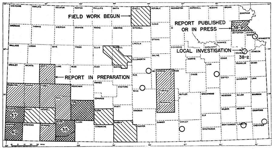
The most productive part of the area described in this report embraces the Arkansas valley between Hutchinson and Wichita and the now filled channel of an ancient stream extending from the border of the Smoky Hill river valley near Lindsborg to Arkansas river near Halstead. A detailed study of the geology and ground-water resources of this area was begun in July, 1937, by the State Geological Survey of Kansas and the United States Geological Survey, with the cooperation of the Division of Sanitation of the Kansas State Board of Health. The location of this area is shown in figure 1. The investigation was greatly enlarged and intensified during the summer of 1938, when the city of Wichita began financial cooperation with the State and Federal agencies in order to determine whether a sufficient quantity of soft, fresh water could be obtained within an economic distance from the city to replace the then existing supply of hard, brackish water. The ensuing investigation, lasting through 1939, led to the development of a new well field situated south and west of Halstead, about 22 miles northwest of Wichita. Twenty-five widely spaced wells were drilled and tested, a pipe line was constructed to carry the water to Wichita, and a treatment plant was constructed at Wichita. The new well field was put into operation on September 1, 1940, and now supplies the city with 10,000,000 to 12,000,000 gallons daily of fresh, relatively soft water. The field was designed for an ultimate daily capacity of 20,000,000 gallons and a peak daily consumption of 30,000,000 gallons.
Figure 1—Index map of Kansas showing area of south-central Kansas studied in detail and other areas for which cooperative ground-water reports have been published or are in preparation. Numbers refer to bulletin numbers of reports published by the State Geological Survey of Kansas.
A summary of the geology and principal hydrologic features of the area has been published (Lohman and Frye, 1940), and a detailed report on the area by S. W. Lohman, John C. Frye, and Charles C. Williams is now nearly completed. This will be published as a bulletin of the State Geological Survey of Kansas.
An observation-well program was begun in Harvey, McPherson, and Sedgwick counties in 1937, and at the present time periodic water-level measurements in about 160 wells in these counties are being made. A majority of the wells are observed weekly, but a few are observed monthly or quarterly; a few are equipped with automatic water-stage recorders that give a continuous record of water levels. The descriptions of the wells and the measured water levels in the observation wells in these counties and in 18 other counties of central and western Kansas are published in the annual water-level reports of the Geological Survey, United States Department of the Interior (U.S. Geol. Survey Water-Supply Papers 840, 845, and 886). The annual water-level report for 1940 is now in press, and that for 1941 is in preparation. It is planned to continue this water-level program for as long a period as possible and to establish observation wells in additional counties from year to year, in order to determine the magnitude and character of water-level fluctuations and the rate at which the underground reservoirs are being replenished by rainfall, or depleted by natural processes or by heavy pumping. Such studies are especially important in areas of heavy withdrawal of ground water, such as the new well field of the city of Wichita. A continuing study is being made of the ground-water levels and pumpage in the well-field area in order to determine the ultimate safe yield of the field.
The present report is intended to call timely attention to the availability in this area of relatively large supplies of ground water that are satisfactory in quality for use by many national defense industries. An abundance of cheap fuel is available from the several large oil and gas fields located within the area described, and a network of railroads and highways provides adequate transportation facilities. The report calls attention only to the broader features of the area; for specific details pertaining to particular parts of the area, interested persons are referred to the office of the State Geological Survey at Lawrence, where information may be obtained regarding logs of many wells and test holes, records of hundreds of drilled wells in the area, and analyses of typical well waters from all parts of the area.
This report has been reviewed by R. C. Moore, state geologist, J. C. Frye, assistant state geologist, and T. G. Payne, editor, of the State Geological Survey of Kansas; by George S. Knapp, chief engineer of the Division of Water Resources of the Kansas State Board of Agriculture; by L. A. Young, acting director, and Ogden S. Jones of the Oil-Field Waste Disposal Section, Division of Sanitation of the Kansas State Board of Health; and by O. E. Meinzer, geologist in charge of the Division of Ground Water of the Federal Geological Survey. Figure 2 was prepared by G. W. Reimer, draftsman of the State Geological Survey. The Kansas State Board of Health kindly supplied information pertaining to the public water supplies of several cities in the southern and western parts of the area described.
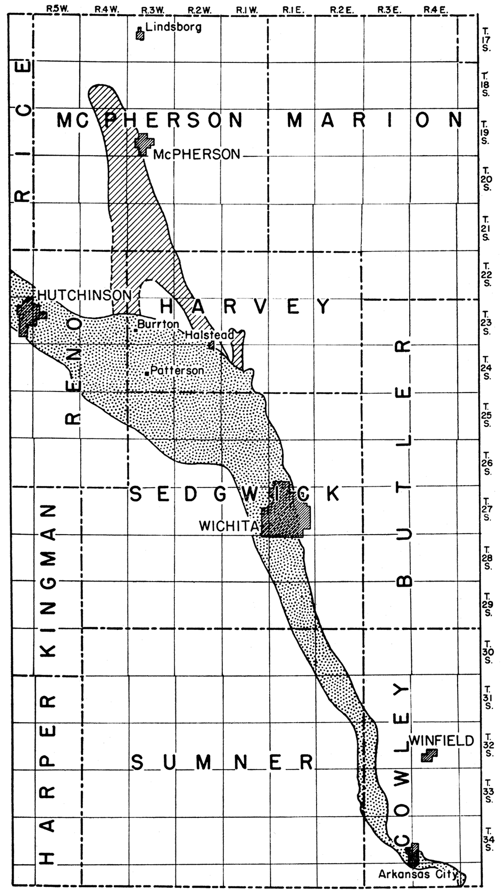
The area in south-central Kansas from which large supplies of ground water may be obtained is divisible for description purposes into three parts: (1) the McPherson filled valley, (2) the Arkansas valley between Hutchinson and Wichita, and (3) the Arkansas valley between Wichita and the Oklahoma state line.
The McPherson filled valley (fig. 2) comprises an ancient river channel now filled with river deposits of gravel, sand, silt, and clay of relatively recent (Quaternary) geologic age. During glacial times the Smoky Hill river and other streams to the north of this area poured a torrent of water through this old channel, from a point near Lindsborg, past the site of the present city of McPherson, to the ancestral Arkansas river at a point near the present city of Halstead. Large quantities of gravel, sand, and silt carried by the swollen stream were deposited in the channel until it became choked with this material. When the ice had retreated entirely from Kansas, the ancestral Smoky Hill river was captured by the Kansas river, and the stream occupying the old "McPherson valley" gradually disappeared (Lohman and Frye, 1940, p. 846). Subsequently, a large part of this old filled valley was covered by fine wind-blown silt (loess) and locally by sand dunes. The presence of the filled valley is not obvious to the untrained observer, but it has been clearly delineated by the drilling of many water wells and test holes, including many test holes put down by the State and Federal Geological Surveys. Test drilling has' given evidence of inconclusive nature indicating possible existence of a second channel to the west of the channel that ends near Halstead (fig. 2), but further testing will be necessary in order to prove the existence of this second channel.
Figure 2—Map of south-central Kansas showing the areas in which large supplies of ground water may be obtained. The McPherson filled valley is indicated by diagonal ruling, the Arkansas valley is indicated by stippling.
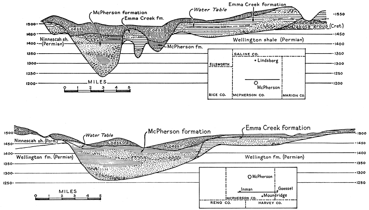
The shape of the old McPherson channel and the character of the filling in McPherson county are shown in figure 3. Farther south, in Harvey county, the filled channel is somewhat narrower and now contains Little Arkansas river, as shown in figure 4.
Figure 3—East-west sections across the McPherson filled valley based upon test drilling and surface exposures.
The deposits occupying the old channel attain a maximum thickness of 150 feet and in most places contain beds of clean gravel or coarse sand, particularly near the base, that yield water freely to wells. The public water supplies of McPherson, Inman, Buhler, Halstead, and Newton are obtained from these deposits; only McPherson and Halstead are situated directly over the old channel. Buhler and Inman are situated several miles west of these deposits, and long pipe lines are used to conduct water from the wells of these cities. Newton is situated several miles east of these deposits and is connected by pipe line to a well field in a small tributary of the main filled valley. The Permian bedrock underlying the channel consists of relatively impermeable shale that yields only small supplies of very hard water. For. this reason, wells should not be deepened below the point at which bedrock is encountered.
The old McPherson channel constitutes the former lower part of the Smoky Hill river channel. The deepening of the Smoky Hill valley and attendant erosion of adjacent areas, however, has removed much of the filling material immediately south of Smoky Hill river; hence the productive water-bearing area ends about midway between McPherson and the river (fig. 2). The alluvium in the present Smoky Hill valley below Marquette also yields abundant supplies of water to wells, as will be described in the forthcoming bulletin noted above.
Prior to the cooperative investigation by the State and Federal agencies, it commonly was believed that water flowed southward from the Smoky Hill river through the channel deposits toward the Arkansas valley. The investigation, however, revealed the presence of a ground-water divide about 5 miles south of McPherson (Lohman and Frye, 1940, fig. 5). North of this divide the ground water moves slowly northward past the city of McPherson and toward the Smoky Hill valley. South of the divide the movement is southward.
From McPherson southward the channel deposits are especially productive. The 4 municipal wells at McPherson are situated along the east bank of the old channel where the deposits are somewhat thinner than they are farther west. The wells range in depth from 137 to 170 feet, and the depth to static water level ranges from 60 to 64 feet. Each well yields more than 1,200 gallons a minute, and one well yields 2,000 gallons a minute with a draw-down of only 27 feet. Daily pumpage from the 4 wells averages only 800,000 gallons but has reached a peak of 3,500,000 gallons. The aggregate capacity of the 4 wells amounts to about 9,500,000 gallons a day, but continuous pumping at this rate probably would deplete the underground reservoir. It is believed that as much as 5,000,000 gallons daily could be pumped locally from the channel deposits south of McPherson without seriously affecting the permanence of the supply. A much larger quantity of water would be available for a period of a few years during the present emergency. Continuous pumping of a larger quantity, however, would entail widespread spacing of many wells over a large section of the channel and would require careful planning and continued observation of water levels.
South of McPherson the deposits are somewhat thinner and the old filled channel is more restricted. Recharge facilities are somewhat better farther south, however, so that with careful planning and adequate preliminary test drilling, comparable quantities of water doubtless can be developed from this part of the filled channel. The depth to water level in the southern part of the channel is only 10 to 25 feet as compared to 50 to 70 feet in the northern part.
The deposits in the tributary valleys generally are finer grained and less productive than those in the main channel. The city of Newton, however, derives its entire supply from wells in one of these tributary valleys (Emma creek). Much test drilling was necessary before the supply wells could be drilled, and, because of the fine-grained nature of the material, some of the earlier wells have had to be replaced by wells of better construction. In 1937 the average daily consumption at Newton ranged from 1,500,000 to 2,000,000 gallons, and the aggregate yield from all wells was reported to be 2,600,000 gallons a day. New wells put down recently have increased the total yield.
The water obtained from the McPherson channel deposits is of good quality in most places. In the vicinity of Halstead the water has a hardness of less than 150 parts per million. At McPherson, however, the hardness of the water is about 340 parts per million, and locally south of McPherson some of the well waters contain appreciable amounts of iron. The chloride content of these waters is low, except locally where they may be somewhat contaminated by oil-field brines from nearby producing fields.
Figure 2, indicates that the Arkansas valley between Hutchinson and Wichita is much wider than it is south of Wichita. Test drilling during the course of investigation by the geological surveys revealed the presence of a bedrock "ridge" that separates two former bedrock channels of the river-one on the north side of the valley and north of Patterson and Bentley, and the other situated beneath the present stream along the south side of the valley (fig. 4, bottom). These two old channels merge into one narrower channel from Wichita southward, and the northern channel merges with the old McPherson filled valley in the vicinity of Halstead.
Figure 4—Section across the filled channel west of Newton (top) and section across the filled Arkansas valley the southern end of the McPherson filled valley (bottom). Based upon test drilling and surface exposures.
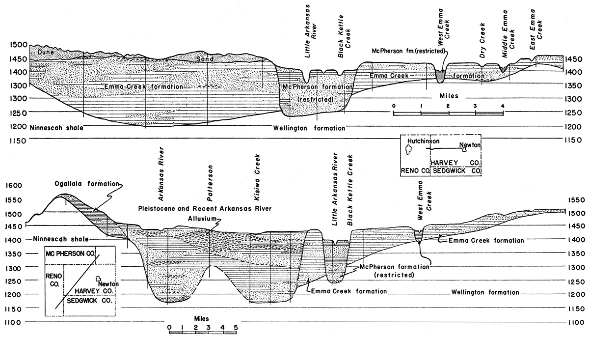
The maximum thickness of the alluvium in the south channel is about 300 feet and occurs southwest of Patterson. The deposits thin downstream to about 80 feet near Wichita and upstream to somewhat more than 100 feet near Hutchinson. The maximum known thickness in the north channel is about 275 feet and occurs southeast of Burrton.
The alluvium consists of unconsolidated gravel, sand, silt, and clay, and in most places contains thick beds of very productive water-bearing gravel and sand. In general the deposits in the south channel are coarser and somewhat more productive than those in the north channel, but there are exceptions to this rule. In general the most productive beds of gravel are encountered within the first 100 feet of drilling, this being particularly true along the south channel. Productive beds of sand and gravel occur also in the area between the two old channels, but there the total thickness of the alluvium is not as great (fig. 4, bottom). The Permian shales that underlie the valley contain only small quantities of hard water; hence wells should not extend below the base of the alluvium.
The thick, extensive beds of gravel and sand make this stretch of the Arkansas valley one of the most productive ground-water reservoirs in Kansas. Most wells of proper construction in the valley yield as much as 1,000 gallons a minute with relatively small draw-down, and some wells yield as much as 2,000 gallons a minute with small draw-down. The depth to water level is less than 25 feet in most parts of the valley and in low areas is only 10 to 15 feet. The sandy nature of the soil provides good facilities for recharge from precipitation. Exceptionally good recharge facilities are provided by the large area of sand dunes on the north side of the valley between Hutchinson and Halstead. Heavily pumped wells near Arkansas river receive additional recharge directly from the river. The Little Arkansas river, however, has cut its channel below the level of the water table and hence does not contribute water to nearby wells. On the contrary, it receives most of its flow by percolation from the ground-water reservoir.
All of the cities in this part of the valley derive their water supplies from wells in the alluvium. The city of Hutchinson has 10 drilled wells ranging in depth from 50 to 80 feet, but normally the entire supply averaging about 3,200,000 gallons a day is obtained from only three of the wells. Nine of the wells have individual yields of from 1,000 to 1,500 gallons a minute, but one well yields only about 500 gallons. The maximum daily pumpage in 1940 amounted to nearly 6,000,000 gallons.
The city of Wichita formerly was supplied from a group of shallow wells in the alluvium at the confluence of the Arkansas and Little Arkansas rivers. Fifteen of these wells were equipped with individual pumps, and each yielded from 750 to 1,700 gallons a minute. Another group of small driven wells was connected by suction lines to one large pump. The average daily pumpage from the old well field was 10,000,000 to 15,000,000 gallons, and peak daily pumpage exceeded 20,000,000 gallons. Although adequate in quantity, the water from the old well field was of very poor quality (see later discussion).
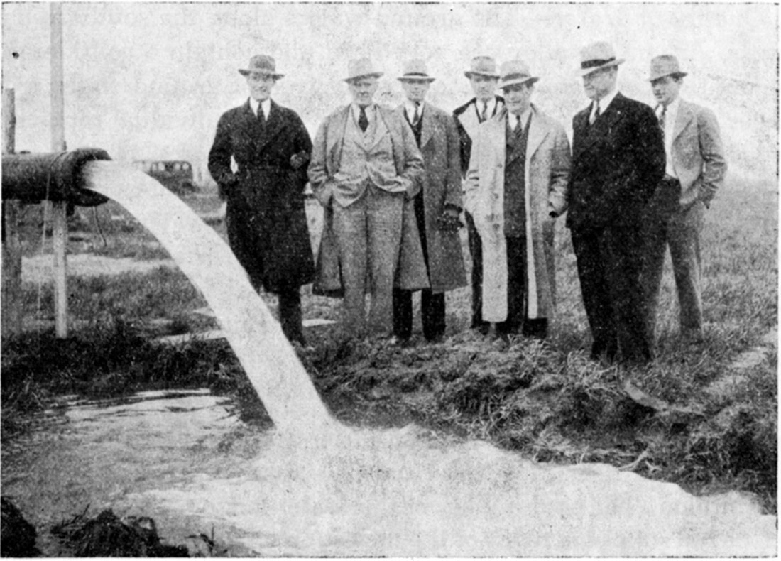
As indicated in the introduction, the present water supply of the city of Wichita is obtained from 25 widely spaced wells situated along the north side of the Arkansas valley, about 22 miles northwest of Wichita. These wells range in depth from 80 to 263 feet. Many of the wells yielded as much as 2,000 gallons a minute when test-pumped, but in order to prevent local overdevelopment the present rates of pumping have been adjusted to range from 500 gallons a minute for the weaker wells to not more than 1,000 gallons a minute for the stronger wells. A view of the testing of one of these wells is shown in figure 5. Only about 8 wells are pumped simultaneously to supply the average daily requirement of 10,000,000 to 15,000,000 gallons, but the well field was designed for an ultimate average capacity of 20,000,000 gallons a day and for peak demands of 30,000,000 gallons a day.
Figure 5—View of discharge from the first Wichita city well in the new supply area near Halstead. The well is discharging 1,600 gallons a minute through a 10-inch orifice, and the draw-down at the close of a 36-hour pumping test was 28 feet.
In the southern part of the Arkansas valley, supplies of from 10,000,000 to more than 20,000,000 gallons a day are available to national defense plants from wells in local areas, and in favorable areas larger supplies could be developed by widespread distribution of wells. Very much larger quantities of water would be available for a period of a few years during the present emergency. The largest supplies are available near the river, where water from the river would be drawn into the wells under conditions of heavy pumping. Large supplies of ground water could not be developed along the northern part of the valley between Burrton and Halstead without seriously endangering the adequacy of the new water supply of the city of Wichita. There are very few irrigation or industrial wells in the greater part of the valley; therefore development of additional large supplies of water from wells would not seriously interfere with existing demands for ground water except in areas close to the municipal well fields of Hutchinson and Wichita and in the heart of the Wichita industrial area.
The ground waters along the southern part of the Arkansas valley are very hard and contain a considerable amount of chloride; this is especially true of ground water from areas near Arkansas river. The water from individual municipal wells at Hutchinson ranges in total hardness from 134 to 593 parts per million, much of which represents noncarbonate or so-called permanent hardness. The chloride content of waters from these wells ranges from about 100 to more than 600 parts per million. At low stages the water in the Arkansas river is somewhat salty, and water from wells near the river generally contains from 400 to 800 parts per million of chloride.
The average hardness of water from the old Wichita well field was about 450 parts per million, most of which represented noncarbonate hardness, and the chloride content was about 500 parts per million. The poor quality of this water led to the abandonment of the old supply in favor of the new supply from the northern side of the valley. The hardness of the water from the new well field averages only 130 parts per million, all of which represents carbonate hardness, and the chloride content is only 25 parts. Some of the ground waters along the northern side of the valley contain a considerable amount of iron, whereas those along the southern side contain very little iron.
In areas between Arkansas river and the new Wichita well field the ground water is intermediate in quality between the extremes given above. Thus, water from wells 2 miles distant from Arkansas river is of much better quality than water from wells within one mile of the river. In and near the Burrton oil field, which extends across the valley west of Burrton, the ground waters in local areas have been rendered salty because of the escape of oil-field brines into the sands and gravels. Through the efforts of the Oil-Field Waste Disposal Section of the Division of Sanitation, Kansas State Board of Health, considerable progress has been made in bettering the conditions in the Burrton oil field, and at present practically all of the brine produced is being conducted to deep disposal wells.
The quality of ground water in some parts of the valley, as indicated above, is not suited to all industrial requirements, but even the poorest water is satisfactory for some industrial uses, and the best water is suitable for most industrial uses.
Figure 2 shows that the alluvium in this section of the Arkansas valley occupies a much narrower belt than in the section of the valley just described. Detailed study has not been made of this section of the valley, but data from several sources indicate that the alluvium here is much thinner than it is upstream from Wichita and in most places probably ranges in thickness from 50 to not more than 80 feet. Beds of permeable gravel and sand are encountered by wells in most parts of the valley.
Individual municipal wells at Mulvane and Arkansas City are only 33 to 43 feet deep and yield from 500 to about 1,000 gallons a minute. The city of Winfield is supplied from shallow wells in the Arkansas valley about 8 miles west of the city. One well equipped with a turbine pump yields 750 gallons a minute. It is probable that somewhat larger yields could be obtained from properly constructed wells in favorable areas, although yields from wells in this section of the valley cannot be expected to be as large as in the section between Hutchinson and Wichita.
Ground-water supplies of as much as 5,000,000 gallons a day can be pumped continuously from local areas in the Arkansas valley between Wichita and the Oklahoma state line, and in favorable areas somewhat larger supplies probably could be obtained. Larger quantities than this would be available for a period of a few years during the present emergency. If more than 5,000,000 gallons a day were required continuously from wells in this section of the valley, the wells would have to be widely spaced over a large area and situated near the river channel so as to take full advantage of percolation from the river.
The quality of ground water in this section of the valley is similar to that in the section upstream from Wichita. The total hardness of representative ground waters ranges from about 300 to more than 400 parts per million, and most waters have considerable non-carbonate hardness. The chloride content of most ground waters ranges from as low as 50 to 100 parts per million to as high as 500 parts per million. Water from wells close to the river generally contains more chloride than that from wells situated a mile or more from the river. Available analyses indicate that most of the ground waters contain very little iron.
Continuous supplies of ground water adequate for most industries, including those related to national defense, generally are not obtainable in south-central Kansas except in the productive valley areas described above.
The areas adjacent to the Arkansas and McPherson filled valleys are underlain largely by Permian rocks, but in some places thin deposits of Tertiary and Quaternary age mantle the Permian bedrock. In northern McPherson county sandstones of Cretaceous age supply some water to domestic and stock wells but do not yield water in sufficient quantity for industrial use.
As indicated by the geologic map of Kansas issued in 1937, most of the area shown in figure 2 in underlain directly by Permian rocks, consisting mainly of shale but also containing thin beds of limestone, gypsum, and other types of sedimentary rock. Most of the shales cropping out in the eastern half of the area are of marine origin and generally are dark-gray or yellowish in color. The shales that crop out in the western part of the area are mostly nonmarine in origin and are red in color.
Wells in Permian shales generally yield only meager supplies of very hard water. Most wells yield enough water in wet years for domestic or stock use, but in dry years many wells fail. In some places Permian rocks yield enough water to supply small towns, but the poor quality of the water generally prohibits such use.
Ground waters from Permian rocks range in hardness from several hundred parts per million to as much as 2,000 parts, and nearly all of the hardness is of the non-carbonate or so-called permanent type. The chloride content of waters from shallow wells generally is low but locally may exceed 100 parts per million; waters from deep wells generally have a chloride content in excess of 100 parts per million. Water of this quality is unsuited for most industrial uses except cooling and fire protection.
Alluvial deposits of Tertiary age occupy a wide, nearly flat area east of the McPherson filled valley in McPherson and Harvey counties and also occupy smaller areas to the west of this old filled valley. The sand and gravel content of these deposits is low; and, except in local channels, the deposits are fine-grained and poorly sorted. Most of the wells ending in these deposits yield sufficient water for domestic and stock use, and a few wells in favorable areas yield 25 to 100 gallons a minute. The waters are of fair quality, except in places where they have been contaminated by oil-field brines.
Deposits of Tertiary age occupy narrow hilly belts in some places southwest of the Arkansas valley. Farther to the west, where these deposits are thick and extensive, they are important water bearers, but in south-central Kansas they generally are thin and carry only small supplies of water. Terrace deposits that border the southern side of the Arkansas valley also generally are thin and relatively unimportant as sources of ground water.
Sand dunes of Quaternary age form an extensive hilly tract north of Hutchinson and Burrton. The fine-grained sand does not yield water readily to wells, but the dunes form an excellent catchment area for rainfall, which is held in the sand until it percolates slowly into the alluvium of the adjacent valley. The fine sand yields small supplies of soft water to a few stock wells.
Alluvial deposits in some of the tributary streams locally are thick and coarse enough to supply sufficient water for domestic and stock use, but in most places such supplies are inadequate for industrial use. Alluvium in some of the larger tributaries, such as Walnut river, yields somewhat larger supplies. In many places, however, the water in the alluvium of Walnut valley has been contaminated by oil-field brine from upstream areas. It is expected that this condition will improve in the future as more oil wells are abandoned and as more of the brine being produced is utilized for repressuring oil wells.
Lohman, S. W., and Frye, J. C., 1940, Geology and ground-water resources of the "Equus beds" area in south-central Kansas: Economic Geology, vol. 35, no. 7, pp. 839-886, figs. 1-5.
Kansas Geological Survey
Placed on web Nov. 3, 2017; originally published Feb. 28, 1942.
Comments to webadmin@kgs.ku.edu
The URL for this page is http://www.kgs.ku.edu/Publications/Bulletins/41_1/index.html