Kansas Geological Survey, Bulletin 38, pt. 10, originally published in 1941
Federal geologist assigned to cooperative mineral fuels project
Consulting geologist, Wichita, Kansas
Originally published in 1941 as Kansas Geological Survey Bulletin 38, pt. 10. This is, in general, the original text as published. The information has not been updated. An Acrobat PDF version (8 MB) is also available.
On August 15, 1941, the McLouth gas and oil field, 15 miles north of Lawrence, Kansas, had 23 gas wells with an aggregate initial open flow of 170 million cubic feet of gas per day, six oil wells with a probable total potential of 250 barrels per day of oil of 24 to 25 degrees gravity Bé. Three dry holes had been drilled. The surface rocks, which are mainly the Lecompton limestone of late Pennsylvanian age, are partly covered by glacial drift. A normal sequence of Pennsylvanian rocks rests disconformably on Mississippian limestones.
The structure shown by the surface rocks is a northeast-trending gentle anticline having a closure of less than 20 feet. The closure of the anticline. increases with depth. The pre-Pennsylvanian structure is marked by faulting, which is not noticeable in the surface structure. There seems to be a definite and pronounced southward shift in the position of the structural crest with increasing depth.
There are three known gas- or oil-producing zones. Most of the gas comes from the McLouth sand at the base of the Pennsylvanian rocks. Three wells produce oil from this zone. The McLouth sand is variable in permeability and in some structurally favorable areas is lacking in porosity. The weathered and porous top of the Mississippian rocks yields gas in some wells. This zone is saturated with oil in some wells but no oil has yet been produced from it. The lowest producing zone to date is a porous dolomite zone in the undifferentiated Burlington-Keokuk limestones from 125 to 150 feet below the top of the Mississippian rocks. This zone yields oil in three wells.
Production of gas from the McLouth sand extends far beyond the area of closure of the anticline as mapped on the gas sand. It is evident that production in this zone is dependent more on the presence of permeable sand than on local structural conditions, though it is possible that the McLouth anticline may prove to be only a part of a much larger anticlinal structure. Production of oil from Mississippian rocks seems to be governed more closely by anticlinal structure than does production from the McLouth sand.
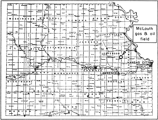
The McLouth gas and oil field is located in northeastern Kansas about midway between Kansas City and Topeka and about 15 miles due north of Lawrence (fig. 1). The producing area includes parts of Jefferson and Leavenworth counties, and all or parts of secs. 28, 29, 32-34, T. 9 S., R. 20 E., and secs. 3-6, T. 10 S., R. 20 E. The field has been named from the village of McLouth, in Jefferson county, which lies less than a mile southwest of some producing wells. The McLouth field is located well within the borders of the structural depression called the Forest City basin and is the first field to produce oil from pre-Pennsylvanian rocks in the Forest City basin in Kansas.
Figure 1--Index map of northeastern Kansas showing location of the McLouth gas and oil field.
This report is a preliminary one, for it is based on information pertaining to development of the field prior to August 15, 1941. The study is sponsored by the State Geological Survey of Kansas and the Federal Geological Survey, as part of a cooperative project to investigate the relationship of oil and gas to stratigraphy and structure in the Forest City basin in Kansas.
The development of the McLouth field began in November, 1939, with the discovery of gas in a well drilled in sec. 4, T. 10 S., R. 20 E. On August 15, 1941, the field contained 23 gas wells, 6 oil wells, and 3 dry holes. The dry holes entered the gas pay sand at points where it lacks porosity and failed to find commercial amounts of oil or gas in deeper rocks penetrated. Little if any water was encountered in any of the wells in the gas sand. The amount of oil produced prior to August 15, 1941, is not large, but study of the field is important inasmuch as its structure presents unusual features that may have bearing on future developments in northeastern Kansas. Widespread interest in the McLouth field on the part of oil and gas operators and of citizens in northeastern Kansas makes desirable the publication of this preliminary report on the area, even though many structural details pertaining to folding and faulting of pre-Pennsylvanian rocks are as yet undetermined.
Discovery of the McLouth field may be credited to Huntsman Haworth, consulting geologist of Wichita and Lawrence, Kansas, whose careful field work on outcrops resulted in the mapping of the anticline on which the field is located. The development of the field up to the present time has been due largely to the activities of D. W. McLaughlin, representing McLaughlin & Sons, principal operator in the field. McLaughlin's persistence in drilling wells in the McLouth area, in spite of the lack of pipe-line facilities and the small production from some of the earlier wells, had resulted on August 15, 1941, in the development of an aggregate total initial open flow of 170 million cubic feet of gas from 23 wells and a potential oil production of approximately 250 barrels per day.
The surface of the McLouth field is underlain by alternating beds of limestone and shale of Pennsylvanian age. Inasmuch as ice of the Pleistocene epoch once covered northeastern Kansas, the Pennsylvanian rocks of the area are to a large extent mantled by sand, clay, and gravel deposits of glacial origin.
Pennsylvanian rocks that crop out in the area belong for the most part to the Lecompton limestone of the Shawnee group in the middle part of the Virgil series, of late Pennsylvanian age. The Pennsylvanian rocks penetrated by drilling in the McLouth field are described in Moore's report on the Pennsylvanian rocks of Kansas (Kansas Geol. Survey, Bull. 22, 1937). The nomenclature and stratigraphic classification used in discussing the Pennsylvanian rocks of this area follow the usage of the Kansas Geological Survey and do not necessarily imply its adoption by the Federal Geological Survey. The subsurface Pennsylvanian rocks immediately underlying the Lecompton limestone consist of thin shale and limestone beds of the Shawnee group. The top of the lowest limestone division, the Oread limestone, has been used as a datum for contouring structure (pl. 3 A). Below the Shawnee group is the Douglas group of the Virgil series. In the McLouth field the Douglas group consists mainly of shale and a few thin sandstone beds.
The Douglas group is underlain by the Lansing, Kansas City and Bronson groups of the Missouri series, which consists of alternating beds of limestone and shale. The lowest limestone of the Bronson group is the Hertha limestone, whose base has been used as a datum for contouring the structure (pl. 3 B). That part of the Missouri series below the Hertha limestone consists mainly of shale and is termed the Bourbon formation.
The Des Moines series, which lies below the Missouri series, is mainly shale. Its upper part, the Marmaton group, includes a number of thin limestones not very carefully logged in some wells. The lower thin limestones of the Marmaton group are included in the Ft. Scott limestone. The lower part of the Des Moines series is the Cherokee shale, which consists almost entirely of shale, sandy shale, sand, and some beds of coal. A thin limestone (Ardmore limestone) is present in the upper part of the Cherokee shale. This limestone would be a valuable datum bed except that it is even more frequently omitted from logs than the limestone beds of the Marmaton group. In cases in which the Ardmore limestone can be detected in the samples, its exact depth is sometimes in doubt. Most of the gas and some of the oil of the McLouth field come from a sandstone (here termed the McLouth sand) near the base of the Cherokee shale.
Pennsylvanian rocks are underlain by Mississippian rocks, most of which are limestone. The Mississippian formations that have been identified in the McLouth field are Salem limestone (Spergen of the Federal Geological Survey) and Warsaw limestone of Meramec age; undifferentiated Burlington-Keokuk limestones of Osage age; Gilmore City and Sedalia limestones of Osage or Kinderhook age, Chouteau limestone of Kinderhook age, and Chattanooga shale, doubtfully placed in the Devonian. Some gas and oil are produced from porous zones in the upper 150 feet of the Mississippian in the McLouth field.
The Chattanooga shale is underlain by Devonian rocks commonly referred to by oil geologists as the "Hunton limestone", Silurian rocks are absent in the McLouth field, as is also the Maquoketa shale. Thus in the McLouth field Devonian limestones rest on the Viola limestone (Kimmswick of Missouri) of Ordovician age. St. Peter sandstone underlies the Viola limestone and overlies the Arbuckle limestone.
Huntsman Haworth, assisted by C. B. Taylor, mapped the surface structure of the McLouth field in April, 1939. Structure contours were drawn on the top of the Big Springs limestone member of the Lecompton limestone. Because bed rock in parts of the area is concealed by glacial drift, a number of shallow test holes were dug in order to obtain additional control points for structural mapping. Part of Haworth's original map is presented in fig. 2. This map was revised by incorporating information obtained from deep wells drilled prior to December, 1940 (plate 1). These maps are published with the permission of Mr. Haworth, to whom the writer is also indebted for much detailed subsurface data.
Figure 2--Original surface structure map of McLouth field by Hunstman Haworth assisted by C. B. Taylor. Structure interpreted from study of outcrops and shallow pits in April, 1939, before drilling began. Contours drawn on top of Big Springs limestone member of Lecompton limestone. Map shows location of discovery well (McLaughlin No. 1 fee) offsetting a dry hole (Stark No. 1 Ragan). Contour interval, 10 feet. Datum, mean sea level.
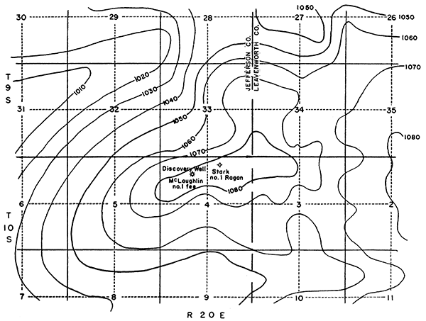
Haworth's map indicates a broad, somewhat irregular, plunging anticline that is about 9 miles long and 2 to 4 miles wide. The axis of the anticline trends northwestward and extends from sec. 1, T. 10 S., R. 20 E., to sec. 7, T. 9 S., R. 20 E. The structure contours in this area, as in other parts of northeastern Kansas, meander somewhat aimlessly, displaying what has been designated by some as "amoebic structure." Several domes with closures of 5 to 20 feet occur on the crest and flanks of the above-described anticline. The McLouth field lies on one of these secondary domes or anticlines on the southwest side of the larger anticline, but the producing area extends far beyond the area of structural closure.
The local structure of the rocks exposed near McLouth, as shown in plate 1, is a broad, gentle anticline about 2lfz miles long and one mile wide. The closure, as determined from the surface, is less than 20 feet. A slight structural saddle bisects the crest of the anticline, giving it the appearance of two domes, a feature that was not suspected in the original work in the area because no outcrops occur in the saddle part of the crest.
The wells completed prior to August 15, 1941, are shown in plate 1. The three oil wells in sections 4 and 5, T. 10 S., R. 20 E., produce oil from Mississippian limestone, which disconformably underlies the Pennsylvanian rocks of this region. The gas is obtained from a lower Pennsylvanian sandstone. Three wells on the south side of the field yield oil from this sand. The production of each well is shown in table 6 and in plate 3 (C and F).
Drilling of the first well, McLaughlin No. 1 fee, NE NW sec. 4, T. 10 S., R. 20 E., was begun on October 7, 1939, and gas was discovered early in November, 1939, in sandstone near the base of the Cherokee shale of early Pennsylvanian age. This sand is currently referred to by drillers and operators in the field as the "Bartlesville" sand, but is designated in this paper as the McLouth sand. Although both the McLouth sand and Bartlesville sand occur in the lower part of the Cherokee shale, they were laid down in separate basins and probably lie at slightly different stratigraphic horizons. In some wells, the McLouth sand is either separated from Mississippian limestone by several feet of dark shale or has shale in its lower part, but in many of the wells sandstone rests directly upon Mississippian rocks.
The discovery well originally gauged 8 1/2 million cubic feet of gas from sand at a depth of 1,426 to 1,440 feet, but the well was later deepened for the purpose of exploring oil production possibilities. From a depth of 1,450 to 1,475 feet an increase in flow of gas into the well was reported. Casing was set and cemented at the top of the Mississippian rocks at a depth of 1,475 feet. Oil and gas were reported as occurring at the top of the Mississippian. Also, porous limestone and dolomite, heavily stained with oil, were penetrated at four other zones between 1,475 and 1,645 feet (170 feet below the top of the Mississippian). Water was reported at depths of 1,635 and 1,650 feet.
The "Hunton" limestone, of Devonian and Silurian age, was penetrated by the discovery well at a depth of 1,872 feet and was drilled to a depth of 1,915 feet. Shows of gas in the "Hunton" limestone were reported. Unsuccessful efforts were made to shut off the water by the use of a packer in order to test this gas zone. Deeper drilling was abandoned after three strings of tools were lost. The hole was then plugged back to the top of the Mississippian rocks. The McLaughlin No. 1 fee well is the deepest thus far drilled in the field; the driller's log is presented in table 1.
Table 1--Driller's log of McLaughlin No. 1 fee well, SW NE NW sec. 4, T. 10 S., R. 20 E., Jefferson County, Kansas. Altitude above sea-level at mouth of well, 1,103 feet. Drilling began October 7,1939; completed December 14, 1939.
| Thickness, feet |
Total depth, feet |
|
|---|---|---|
| Soil | 3 | 3 |
| Clay | 4 | 7 |
| Shale | 23 | 30 |
| Lime | 5 | 35 |
| Shale | 69 | 104 |
| Lime | 12 | 116 |
| Shale | 64 | 180 |
| Red rock | 2 | 182 |
| (2 bailers of water per hour at 300 feet) | ||
| Shale | 223 | 405 |
| Lime | 45 | 450 |
| Shale | 4 | 454 |
| Lime | 5 | 459 |
| Shale | 16 | 475 |
| Lime | 30 | 505 |
| Shale | 20 | 525 |
| Lime | 15 | 540 |
| (2 bailers of water per hour at 540 feet) | ||
| Shale | 23 | 563 |
| Lime | 15 | 578 |
| Shale | 20 | 598 |
| Lime | 8 | 606 |
| Shale | 9 | 615 |
| Lime | 42 | 657 |
| Shale | 4 | 661 |
| Lime | 7 | 668 |
| Shale | 4 | 672 |
| Lime | 40 | 712 |
| Shale | 2 | 714 |
| Lime | 5 | 719 |
| Shale | 2 | 721 |
| Lime | 25 | 746 |
| Shale | 4 | 750 |
| Lime | 10 | 760 |
| Shale | 5 | 765 |
| Lime | 5 | 770 |
| Shale | 17 | 787 |
| Lime | 5 | 792 |
| Shale | 60 | 852 |
| Sand | 20 | 872 |
| Red rock | 3 | 875 |
| Shale | 30 | 905 |
| Lime | 45 | 950 |
| Shale and lime | 20 | 970 |
| Shale | 20 | 990 |
| Lime | 5 | 995 |
| Sandy shale | 24 | 1019 |
| Shale | 68 | 1087 |
| Lime | 4 | 1091 |
| Sandy lime | 4 | 1095 |
| Shale | 5 | 1100 |
| Sand | 4 | 1104 |
| Sandy shale | 16 | 1120 |
| Shale | 67 | 1187 |
| (Correction: 1350 equals 1337) | ||
| Sandy shale | 239 | 1426 |
| "Bartlesville" (McLouth of this report) | ||
| Sand--gas | 17 | 1443 |
| Shale | 4 | 1447 |
| Sdy. shale | 3 | 1450 |
| Sand--gas | 25 | 1475 |
| Mississippi lime show oil, gas |
345 | 1820 |
| Shale | 55 | 1875 |
| Lime (Devonian "Hunton") gas | 40 | 1915 |
Several zones in the discovery well (McLaughlin No. 1 fee), as indicated by the driller's log (table 1), yielded water in minor amounts; some water was found in other wells drilled in the field. Water has been reported most frequently from the zones listed below, but is by no means universally present. No water has yet (August 15, 1941) been encountered in the McLouth sand.
Water-bearing zones that have been found in the McLouth field and the amount of water reported (bailers per hour) are as follows, in downward order: Tonganoxie sandstone member of Stranger formation (2 to 6 bailers); top of Stanton limestone (2 to 4 bailers); top of Wyandotte limestone (2 bailers); top of Hertha limestone (3 bailers to hole full of water); sandstone lenses and beds in the middle and lower Cherokee shale (2 to 20 bailers); porous zones of the Mississippian in structurally low positions, as in Stark No, 1 Ragan well (8 bailers).
The second well drilled in the McLouth field (Young and Longwell No. 1 McLeod), which was started April 7, 1940, is located a short distance south of the surface crest of the anticline in center of S2 NW SW sec. 4, T. 10 S., R. 20 E. This well penetrated as sequence of Pennsylvanian rocks similar to that in the discovery well except that no porous sand corresponding to the McLouth sand of the discovery well was encountered. The position of the McLouth sand is occupied by shale with thin streaks of dense sandstone partly stained by oil but containing no gas. The well was drilled deeper to test the oil-stained porous zones of the upper Mississippian rocks encountered in the original well. The top of the Mississippian rocks, at a depth of 1,469 feet, showed some free oil, and many samples of Mississippian limestone and dolomite down to a depth of 1,594 feet were found to be porous and stained by oil. When drilled to a depth of 1,594 1/2 to 1,596 feet, the well filled to a height of 1,200 feet with black oil of 20.7 degrees Bé. gravity; 72 barrels of oil were pumped during the first 24 hours and 32 barrels of oil during the next 30 hours.
Table 2--Stratigraphic horizons and divisions in the McLaughlin No. 1 fee well; determinations based on study of samples and residues by Wallace Lee. Correction of depth distributed
| feet | |||
|---|---|---|---|
| Pleistocene | |||
| Glacial till | 0-30 | ||
| Pennsylvanian | |||
| Lecompton limestone (base only) | 30-35 | ||
| Oread limestone (top) | 95 | ||
| Tonganoxie sandstone (top) | 300± | ||
| Stanton limestone (top) (top of Lansing group) | 411 | ||
| Plattsburg limestone (top) | 470 | ||
| Wyandotte limestone (top) | 520 | ||
| lola limestone (top) | 592 | ||
| Drum limestone (top) | 609 | ||
| Block limestone (top) | 655 | ||
| Winterset limestone (top) | 666 | ||
| Bethany Falls limestone (top) | 712 | ||
| Hertha limestone (at base of Bronson group) | 743-763 | ||
| Marmaton group | 905-995 | ||
| Cherokee shale | 995-1475 | ||
| Ardmore limestone (top) | 1077 | ||
| Siltstone above McLouth sand (top) | 1415 | ||
| McLouth sand ("Bartlesville") | 1526-1475 | ||
| Mississippian (top) | 1475 | ||
| Salem (Spergen) dolomite | 1475-1503 | ||
| Warsaw limestone | 1503-1530 | ||
| Burlington-Keokuk limestone, undivided | 1530-1685 | ||
| Gilmore City limestone | 1685-1708 | ||
| Sedalia limestone | 1708-1722 | ||
| Chouteau limestone | 1722-1820 | ||
| Devonian (?) | |||
| Chattanooga shale | 1820-1874 | ||
| Devonian | |||
| "Hunton" limestone | 1874-1915 | ||
A considerable amount of caving occurred in the Young and Longwell No. 1 McLeod well during the drilling of the upper part of the Mississippian limestones. This was attributed by some observers to caving in the weathered zone at the top of the Mississippian, but the presence of slickensided chert and comparison of the Mississippian rocks of this and other deep wells of the field indicate that the McLeod well was drilled through a fault or fault zone, as shown in the cross-section of plate 2B. The fault is probably a tension fault having a down-throw of about 60 feet on the south side. The fault strike evidently trends slightly north of east.
Table 6 gives the initial production and other information pertaining to the McLaughlin and McLeod wells and to other wells drilled to the McLouth sand prior to August 15, 1941.
Plate 1--Surface structure map of McLouth field by Huntsman Haworth, with recorded data derived from wells drilled prior to December, 1940. Contours drawn on top of Big Springs limestone member of Lecompton limestone, altitude of this datum recorded at wells shown with designation "B.S. ls."
The map also shows location of wells completed prior to August 15, 1941 and position of cross-sections, A-A' and B-B'.
Oil wells in sections 4 and 5 produce from Mississippian dolomite (Burlington-Keokuk) ; those in section 3 produce from McLouth sand.
Names of owners are given on upper part of lease areas (new land owner indicated in parentheses) and names of operators in lower part.
Contour interval, 10 feet. Datum, mean sea level.
[This figure also available as a larger Acrobat PDF file.]

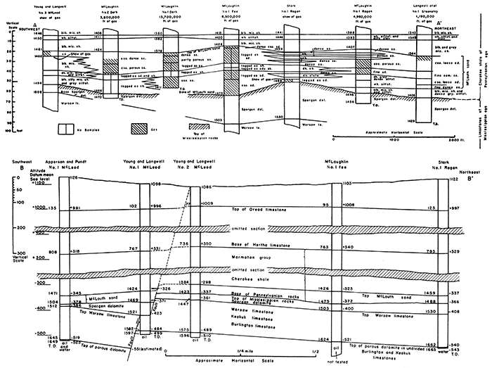
Plate 2--Geologic cross-sections of the McLouth field. [This figure also available as a larger Acrobat PDF file.]
A. Cross-section of McLouth sand along line A-A' (pl. 1) in a northeast direction along crest of McLouth anticline (secs. 3,4, and 5, T. 10 S., R. 20 E.) Variations in thickness and lithologic character of sand interpreted from study of logs and examination of well cuttings. Well logs are correlated utilizing the white siltstone horizon, 11 to 21 feet above top of McLouth sand zone, as the upper datum plane. Some well logs do not record sand unless it contains oil, gas, or water. The top of the gas pay portion of the McLouth sand is below the top of the McLouth sand proper in some wells. The cross-section also shows the position of the top of the Mississippian rocks and the top of the Warsaw limestone in relation to the white siltstone. On the assumption that the top of the white siltstone was originally horizontal, the top of the Mississippian had a relief of 10 to 12 feet on the line of the cross-section. Depths below surface shown by figures at left of well columns.
B. Cross-section of McLouth field along line B-B' (pl. 1) showing structural relationships of Pennsylvanian and Mississippian rocks. It is significant that the anticlinal dips are gentle in younger Pennsylvanian rocks but progressively steeper with increasing depth. In older Pennsylvanian rocks the anticlinal crest passes near the Young and Longwell No. 2 McLeod well. In Mississippian rocks the structural crest adjoins a fault, and the crest of the anticline passes near the Young and Longwell No. 1 McLeod well. The numbers at right of well columns indicate altitude in feet above and below sea-level; those at left indicate depth below land surface. The two cross-ruled bands represent parts of the logs that are omitted in the diagrammatic section.
Abbreviations
blk--black
cem--cemented
cse--coarse
dense--close-grained and lacking in porosity
dol--dolomite
mic--micaceous
sd--sand
sh--shale
siltst--siltstone
ss--sandstone
wh--white
ls--limestone
Three zones in the McLouth field yield oil or gas: (1) the McLouth sand, (2) the weathered zone at the top of the Mississippian rocks, and (3) a zone of porous dolomite in the undifferentiated Burlington-Keokuk limestone occurring 121 to 128 feet below the top of the Warsaw formation. In addition to the zones just indicated, shows of gas were reported from the top of the Devonian ("Hunton") in the discovery well. Three deeper zones that have yielded oil and gas in other parts of Kansas have not yet been tested in the McLouth field. These occur in rocks that are designated by oil geologists as Viola limestone, St. Peter sandstone, and Arbuckle limestone.
The McLouth sand is the principal gas-producing zone in the McLouth field. Three wells were producing oil from this zone on August 15, 1941. These wells are on the south flank of the anticline and on the down throw side of the fault. On the north flank of the anticline, a considerable amount of free oil was found in the MeLouth sand in Archie No. 1 Shrader well (sec. 28, T. 9 S., R. 20 E.), but the flow of oil was not maintained and the well was finally completed as a small gas well.
The McLouth sand constitutes a zone of sandstone and shale of varying character and occupies the basal part of the Cherokee shale of early Pennsylvanian age. In most wells the zone is 40 to 50 feet thick, but in the depressed belt south of the fault (pl. 3, C and F) the zone is thicker. The sand zone is 89 feet thick in the Magnolia No. 1 Kell estate well and 75 feet thick in Sherrod et al. No. 1 Momyer, but it thins to 33 feet in Apperson and Pundt No. 1 McLeod and to 29 feet in Stark No. 1 Ragan. In some wells the McLouth sand consists entirely of sandstone, but some parts of the sandstone lack permeability because of low porosity. In most of the weils a shale bed in the middle part of the zone divides the sandstone into upper and lower parts, either or both of which may be productive depending on the porosity. In a few wells, the McLouth sand consists mainly of shale with only thin streaks of dense nonporous sandstone. Six wells (August 15, 1941) have failed to show appreciable porosity in the McLouth sand: Young and Longwell Nos. 1, 2, and 3 McLeod; Stark No. 1 Ragan, Sherrod et al. No. 1 Momyer; and Magnolia No. 1 Kell estate. The first three, however, yielded oil from Mississippian rocks and are not classified as dry holes. Part of the McLouth sand in the last well was heavily saturated with oil.
The cross section A-A' (pl. 2) shows the variations in thickness and lithology of the McLouth sand in a northeast direction across the field; it was compiled from the study of well logs and from examination of well cuttings. Only lower Pennsylvanian rocks and upper Mississippian rocks are shown in the cross-section. Correlation of the columnar sections of the wells utilizes as a datum plane the top of a distinctive grayish-white siltstone or "white shale" that is commonly present above the McLouth sand. This siltstone, 2 to 5 feet thick, is a good horizon marker. Its top varies in position from 11 to 21 feet above the top of the McLouth sand, but in many of the wells the exact measurement of this interval is difficult to determine. Some drillers have logged the McLouth sand only if the rock contained gas or oil.
Much of the McLouth sand is a nonporous sandstone. The low porosity is either due to the presence of a clay or silt matrix between the sand grains or to the presence of secondary calcareous or siliceous cement. Accordingly, the top of the gas sand, as reported in the well logs, does not represent the same stratigraphic horizon in every well. For structural purposes the position of the top of the McLouth sand has been taken to be coincident with the upper limit of definite sandstone, porous or otherwise, below the siltstone, The siltstone would be an excellent key horizon were it not that in some wells the top of the siltstone lies at an undeterminable altitude, somewhere within a space of 10 feet or more that is represented by a single sample of well cuttings. The thickness of beds between the siltstone and the top of the McLouth sand in the McLaughlin No. 1 fee well, shown in the cross-section, is less than it is in the other wells (pl. 2A). The actual decrease in this interval is, however, only 5 feet; part of this may be due to inaccuracies in estimating the depth of the samples or in interpreting the position of the siltstone or top of the sand in this well.
As shown in the cross-section (pl. 2A), the McLouth sand is variable both as to lithologic character and as to porosity; this variation is due to lateral variations in sedimentation. Some coarse sandstone phases are lacking in porosity, and the clean, coarse permeable sandstone of some wells evidently grades progressively into muddy sandstone and into siltstone, laminated siltstone, and micaceous shale in other wells. In those wells in which the McLouth sand consists of an unbroken vertical sequence of sandstone, the middle part consists of fine sandstone or siltstone that seems to be the local equivalent of the shale and the sandy shale separating the upper and lower sand bodies of other wells. One may regard the sandstone layers as stratified lenses deposited in shallow erosional basins or channels, but the evidence now available seems to favor lateral gradation in deposition as explanation of the irregularities of the sand distribution in the McLouth field.
The porosity and, therefore, the productivity of the McLouth sand is erratic. In some areas, as in the SW NW and NW SW sec. 3, the McLouth sand consists mainly of pervious sandstone, but some wells in and adjacent to the NW SW sec. 4, encountered shale containing only streaks of impervious sand. In the Stark No. 1 Ragan well in NW NE sec. 4, as already pointed out, the McLouth consists almost entirely of shale that bears only thin streaks of impervious sand; this is almost surrounded by wells that encountered enough porous sand to constitute wells of average production. Gas production is dependent on the permeability of the 40 to 50 feet of sandstone and sandy, silty, and micaceous shale that constitute the McLouth sand. Gas is produced from all parts of the sand that are sufficiently pervious. Wells that failed to produce gas or oil were dry because they encountered the McLouth sand at points where it lacks porosity. The oil wells, Longwell et at Nos. 1 and 2 Bankers Life (SW sec. 3, T. 10 S., R. 20 K), and Apperson and Pundt No. 1 Steenstry (SW SE NW sec. 3, T. 10 S., R. 20 E.) produce oil from a porous phase of the McLouth sand on the south flank of the anticline.
The Bankers Life No. 1 well on the south slope of the anticline penetrated the top of the McLouth sand at an altitude of -342 feet, 27 feet lower than in Longwell et al. No. 2 Steenstry. The latter well, which is the largest gas producer in the field is located one quarter mile north of the Banker's Life No. 1 well. On the north side of the anticline the Archie et al. No. 1 Shrader well (SE SW sec. 28, T. 9 S., R. 20 E.) found a considerable amount of oil in the McLouth sand, which was topped at an altitude of -371, 29 feet lower than in the McLaughlin No. 1 Bartlett well (lowest gas well to the south). Judging from these regional relations, it might be supposed that the gas-oil contact is 30 feet or more lower on the north side of the anticline than on the south side but other wells fail to corroborate any regularity of the gas oil contact.
The Anderson No. 1 McLeod-Wisdom well, the second largest gas well in the field (August 15, 1941), encountered the top of the McLouth sand in a lower position than in the Archie No. 1 Shrader well (pl. 3C). Also, the Longwell No. 2 Bartlett well in SW SE sec. 33, T. 9 S., R. 20 E. (on August 15, 1941, not yet drilled in), encountered oil in the top of the McLouth sand 36 feet higher than in the Archie No. 1 Shrader and 7 feet higher than in McLaughlin No. 1 Bartlett, the latter a gas well. It is probable, therefore, that the occurrence of oil in the McLouth sand is erratic, and its distribution is in part controlled by factors other. than gravitation. No water has yet been found in the McLouth sand, and the gas extends far beyond the area of closed contours on the, McLouth sand.
The second producing zone in the McLouth field consists of the weathered upper part of the Salem (called Spergen by the U.S. Geological Survey) dolomite; at the top of the Mississippian section in this part of Kansas. The, zone yields some gas or shows of oil in all the wells drilled into it. The Young No. 1 McLeod well, which penetrated the top of the Mississippian on the down-throw side of the fault, had a show of heavy, free oil, but no oil was actually produced. The zone of weathered Mississippian rocks yields gas in McLaughlin No. 2 Bartlett, McLaughlin No. 1 Ragan, McLaughlin No. 2 Dark, and in other wells. The Salem consists of dense, finely sucrose, silty dolomite containing a small amount of chert. Its porosity is due to its position at the top of the local succession of Mississippian rocks and its exposure to weathering and leaching before becoming buried beneath early Pennsylvanian sediments. In many wells the Salem beds are immediately overlain by a sandstone phase of the McLouth sand, but in others (pl. 2) black micaceous and silty shale intervenes.
There is but little chert in the Salem dolomite. The Pennsylvanian basal conglomerate that in most places is composed mainly of residual chert derived from the weathering of uppermost Mississippian rocks is accordingly thin, inconspicuous, or absent in the McLouth area.
The third producing zone in the McLouth field is a porous cherty dolomite, 10 to 20 feet thick, beneath a thick section of cherty limestone in the undifferentiated Burlington-Keokuk limestone of early Mississippian age. The top of this porous dolomite zone lies 121 to 128 feet below the easily recognizable lower boundary of the Salem (Spergen) rocks. The porous dolomite is the producing zone of the three McLeod oil wells in sections 4 and 5, T. 10 S., R. 20 E. In the discovery well (McLaughlin No. 1 fee, NE NW sec. 4) the Burlington-Keokuk zone is heavily oil-stained at a depth of 1,624 feet, but was not tested because of mechanical difficulties. Water was reported at a depth of 1,635 feet.
The Stark No. 1 Ragan well (NW NE sec. 4), which is 17 feet lower on the Big Springs datum bed, found water in the Burlington-Keokuk zone. The structural relations of this zone indicated by the six wells drilled into it are shown by contours in plate 3F.
In the McLaughlin No. 1 fee well, the thickness of the Mississippian limestone section is 345 feet, and of the Chattanooga shale 54 feet. In McLaughlin No. 1 Thorpe, sec. 27, T. 10 S., R. 20 E., 4 miles distant, the Devonian limestone (known locally as the "Hunton") rests upon Kimmswick (Viola of oil geologists) limestone. The Maquoketa (Sylvan of Oklahoma) shale, which normally intervenes between the "Hunton" and Kimmswick limestones, was eroded in the vicinity of McLouth and toward the southeast, during a pre-Devonian cycle of erosion. The thickness of the combined Devonian and Kimmswick beds in this well is 394 feet, and that of the St. Peter sandstone is 76 feet.
Approximate depths below the top of the Mississippian rocks of various key horizons, listed in downward order, are as follows: (1) top of Chattanooga shale, 350 feet; (2) top of Devonian ("Hunton") limestone, 400 feet; (3) top of St. Peter sandstone, 800 feet; (4) top of Arbuckle dolomite, 880 feet; (5) top of Roubidoux sandstone, 925 feet; (6) top of pre-Cambrian granite, 1,525 feet. The thickness of the Mississippian strata varies somewhat from well to well, part of this variation being due to erosion of the Mississippian rocks. As may be seen in the cross-sections (pl. 2), the thickness of the upper part, the Salem (Spergen) dolomite, varies according to the structure of the pre-Pennsylvanian rocks and according to the topographic relief of the surface on which the Pennsylvanian rocks were deposited. The amount of erosion which occurred between the deposition of the Devonian rocks and the Kimmswick limestone also varies.
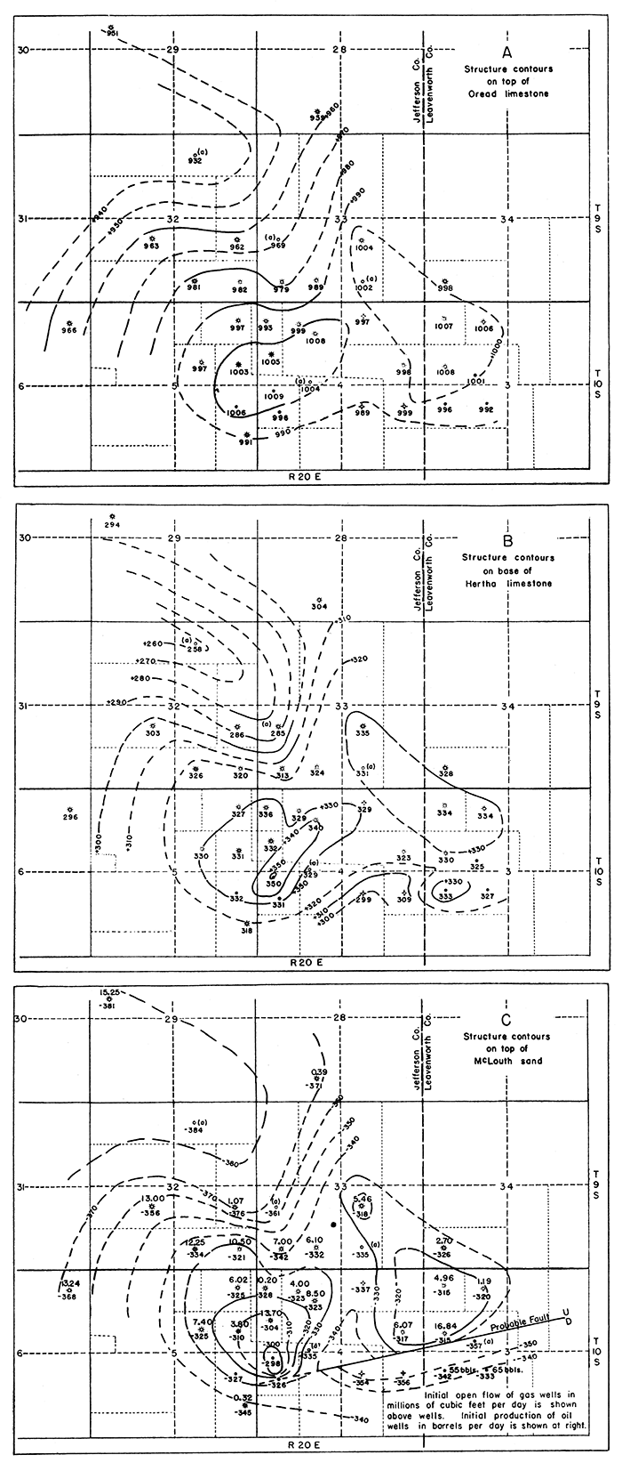
Plate 3 shows the structure of the rocks in the McLouth field as represented by selected datum horizons, which in downward order are as follows: top of the Oread limestone (pl. 3A), base of the Hertha limestone (pl. 3B), top of the McLouth sand (pl. 3C), top of the Mississippian rocks (pl. 3D), top of the Warsaw limestone (pl. 3E) , and top of the porous dolomite in the Burlington-Keokuk limestones (pl. 3F). Control points are those that can be determined from the 36 wells drilled (or drilling) prior to August 15, 1941. The information given in table 2 is based primarily on drillers' logs, checked and corrected by study of well cuttings on file at the State Geological Survey at Lawrence. In a number of the earlier wells the importance of determining depths accurately was not realized and corrections of 10 to 15 feet in the depths to the recorded beds were made in some wells. Two kinds of corrections have been applied. Obvious inaccuracies in some logs are shown by evidence from study of the samples, which indicates that the exact tops of datum beds are not recorded correctly in the logs. Correction of depths has been made when remeasurement of the hole indicated that the depth, as first recorded, was in error. It is impossible to ascertain whether such an error is the result of accumulated small errors or whether it is the result of mistake in the depth at a single point such as may occur when crews are changed. Corrections of the types just indicated result in departure from depths as given in the logs. Depths as recorded in drillers' logs, as well as corrected depths, are indicated in table 6. Adjustments of this nature are not entirely satisfactory but it is believed that the revised depths are more accurate than those given in the drillers' logs. Discrepancies in contouring the McLouth sand may be introduced by differences of opinion as to what constitutes the top of the McLouth sand, inasmuch as the porosity and general character of strata in the position of the McLouth sand vary from well to well. The top of a coarse sandstone (microscopically determined) that occurs below white siltstone has been used for purposes of structure contouring, although in many wells the top of this coarse sandstone is not the top of the productive zone. Under these circumstances it is probable that no two geologists would produce exactly the same structure maps.
Plate 3--Maps showing structure of the McLouth field as expressed by various key horizons: (A) top of Oread limestone, (B) base of Hertha limestone, (C) top of McLouth sand, (D) top of Mississippian limestone, (E) top of Warsaw limestone, and (F) top of porous dolomite in undifferentiated Burlington-Keokuk limestone 128 feet below top of Warsaw. The maps show increasing steepness of dips with increasing depth and they indicate a southward shift of the anticlinal crest from the position defined by the structure of surface beds (Big Springs limestone) near McLaughlin No. 1 fee in NE NW sec. 4 (fig. 2) to a position on the upthrow side of the fault in Mississippian rocks in Young and Longwell No. 1, McLeod in NW SW sec. 4 (pl. 3F).
Contour interval, 10 feet. Figures below well symbols represent altitudes at which contoured horizons were encountered in wells. Wells for which complete information had not been obtained or which had not been completed by August 15, 1941 are marked (a).
Initial production of oil and gas by wells in McLouth sand is shown in plate 3C. Initial production of oil from wells in Mississippian dolomite is shown in plate 3F.
[This figure also available as a larger Acrobat PDF file.]
The series of structure maps (pl. 3) shows that the structural relief gradually increases with depth. A rough measure of the increased relief downward is given by the progressively greater depth of each datum in Young and Longwell No. 1 McLeod well below its position in Young and Longwell No. 2 McLeod, as shown in table 3.
Table 3--Differences in altitude of datum beds in Young and Longwell No. 1 McLeod with respect to their position in the Young and Longwell No. 2 McLeod well.
| feet | |
|---|---|
| Big Springs limestone member of Lecompton limestone (surface) | -6 |
| Top of Oread limestone | -13 |
| Base of Hertha limestone | -19 |
| Top of McLouth sand | -28 |
| Top of Mississippian limestone | -34 |
| Top of Warsaw limestone, south of fault | -62 |
| Top of porous dolomite (calculated), south of fault | -67 |
| Top of Warsaw limestone (calculated), north of fault | +5 |
| Top of porous dolomite, north of fault | +5 |
The form of the McLouth anticline, as expressed by the top of the Oread and the base of the Hertha limestones, does not differ greatly from that expressed by the Big Springs limestone at and near the surface, as shown in plate 1. The dip and closure, however, increase with increasing depth, and a southward shift in the position of the crest of the anticline occurs. The structure as expressed by the top of the McLouth sand shows an accentuation of the anticline as compared with that indicated by the Hertha datum. The abrupt southward drop of the top of the sand in SW sec. 3 and SE sec. 4, T. 10 S., R. 20 E., is interpreted as indicating renewed movement of the pre-Pennsylvanian fault in this area during the deposition of the McLouth sand and shortly afte~ward. Only slight movements over the fault occurred during Pennsylvanian time in SE sec. 4 and SE sec. 5, however.
The resemblance of the fold at the top of the McLouth sand to that at the top of the Mississippian rocks is obvious. These two key horizons are only 45 feet apart. The differences between the contours on the McLouth sand and those on the top of the Mississippian rocks are due mainly to the topographic relief of the surface of the Mississippian; as suggested by the cross-section [pl. 2B), they amount to 10 or 12 feet within the area of the McLouth field.
The structure, as indicated by a datum in the Mississippian rocks, differs from that shown by a Pennsylvanian key horizon. In the surface beds the crest of the anticline is broad. According to Haworth's corrected map (pl. 1) , the crest is nearly flat. The Big Springs limestone is higher by only one foot (see pl. 1 and cross-section; pl. 2B) in the discovery well than it is in Young-Longwell No. 2 McLeod well. On the top of the Oread, the crest differs but slightly from that on the Big Springs limestone. The differences shown by the altitudes of the crests of these beds is probably less than the error in determining the altitudes. On the base of the Hertha limestone and on the top of the McLouth sand, however, the rest of the anticline is definitely in Young and Longwell No. 2 McLeod; and, has has already been pointed out, the deformation here has increased considerably.
In the Mississippian rocks two datum beds have been used; one of these is the top of the Warsaw limestone, the other is the top of a porous dolomite in the undifferentiated Burlington-Keokuk limestone, 128 feet lower. On the north side of the fault (pl. 2B), both of these datum horizons rise regularly from Stark No. 1 Ragan to Young No. 1 McLeod well, where the Mississippian rocks at their highest known point abut against the fault. Immediately south of the fault they are estimated to be at least 62 feet lower structurally, but in Apperson No. 1 McLeod these beds apparently rise again toward the south (pl. 2B).
A fault displacement of 62 feet is expressed in the Warsaw limestone; The top of the McLouth sand in the Young-Longwell No. 1 McLeod well, however, is only 28 feet lower than it is in No. 2 McLeod, indicating that about 34 feet of the displacement of Mississippian rocks had occurred prior to the deposition of the Pennsylvanian beds, The base of the Hertha and the top of the Oread limestones show, respectively, 19 and 13 feet difference in altitude in the two wells. Only 6 feet difference in altitude was noted by Haworth in the surface rocks. These relations indicate existence of a pre-Pennsylvanian fault having a throw of about 34 feet. Faulting of the Mississippian rocks was increased from 34 to 62 feet during Pennsylvanian deposition. The displacement in the Pennsylvanian rocks, which consist chiefly of shale, seems to be expressed mainly by a steepening of their dip. The deformation of the early Pennsylvanian strata was increased by slight movements during the deposition of the later Pennsylvanian rocks. The uppermost Pennsylvanian rocks were deposited after most of the movement had taken place, so that the deformation dies out as the surface is approached. The surface beds show little or no expression of the fault and even their dip is low.
It is important to note that the crest of the anticline in the Mississippian rocks adjoins the fault (pl. 2B) in the Young and Longwell No. 1 McLeod well. The crest of the anticline in the Pennsylvanian rocks is ill-defined and low. The cross-section (pl. 2) indicates that the crest of the surface rocks passes through the location of the McLaughlin No. 1 fee well, or near to it. The crest of the anticline shifts materially with increasing depth, although perhaps not as much as the half mile that separates the McLaughlin and McLeod wells, since this distance is measured diagonal to the strike of the fold. The surface beds between these two wells drop 7 feet toward the southwest, but the top of the porous dolomite zone of the Burlington-Keokuk beds rises 37 feet in the same direction.
The first structure map of the surface beds prepared by Haworth from outcrops and shallow pits is presented in fig. 2 for comparison with the map as later revised by the addition of data furnished by wells. The slight saddle that was later indicated on the crest of the anticline was not evident from study of the outcrops. According to the structure as represented on Haworth's, original map, the site of the Stark No. 1 Ragan well seems almost, if not quite, as favorably located for a test as the site of McLaughlin No. 1 fee well which was finally chosen. The Stark No. 1 Ragan well, however, is one of the few unproductive wells in the pool (August 15, 1941). It encountered the McLouth sand at a point where there is no appreciable porosity and it found water in the porous Mississippian dolomite (Burlington-Keokuk), which was penetrated 57 feet down dip from its position in the No. 1 McLeod where oil was present.
It is almost certain that if the first well drilled in the McLouth area had been Stark No. 1 Ragan, the anticline would have been abandoned, as in the case of other low anticlines of the Forest City basin that have been tested and found dry. The fact that the crest of the anticline shifts laterally in the deeper rocks would not have been indicated by the single well nor would the presence of porous and productive gas sands at a point only one location distant have been discovered. It is not impossible, therefore, that some anticlines in the Forest City basin that have been considered adequately tested have been unnecessarily condemned, through failure to recognize the relation of the structure in the Pennsylvanian to folds and faults in pre-Pennsylvanian rocks. The differences, both in the amount and in the position of maximum deformation at various depths, indicate that the "amoebic" structure of the surface formations is the faint expression of more definite and stronger folding and faulting in the older rocks. The interpretation of the meaning of the surface structural features in terms of the deeper rocks will depend on a better understanding of the nature--still only slightly known--of the pre-Pennsylvanian deformation of eastern Kansas.
The analyses of oil from the McLouth pool were made by J. G. Crawford in the laboratory of the Federal Geological Survey at Casper, Wyoming, under the direction of H. J. Duncan, Supervisor. The first (table 4) is an analysis of oil from the McLouth sand taken from the Longwell et al. No. 1 Bankers Life well. The second (table 5) is an analysis of oil from Mississippian dolomite 128 feet below the top of the Warsaw and 141 feet below the top of the Mississippian in Young and Longwell No. 3 McLeod.
Table 4--Analysis of crude oil from McLouth sand in Longwell et al. No. 1 Bankers' Life (Fred McLeod), NW SW sec. 3, T. 10 S., R. 20 E., McLouth oil and gas field, Leavenworth county, Kansas. Depth 1,438 to 1,450 feet.
| General Characteristics | |
|---|---|
| Specific Gravity | 0.905 |
| A.P.I. Gravity | 24.9 |
| Percent Sulphur | 0.75 |
| Pour point | 5° F |
| Saybolt Universal Viscosity at 100° F. | 424 sec. |
| Color | Black |
| Distillation, Bureau of Mines, Hempel Method | |||||||
|---|---|---|---|---|---|---|---|
| Temperature ° C |
Percent cut |
Sum percent |
Sp. Gr. of cut |
° API of cut |
Viscosity at 100° F |
Cloud test ° F |
Temperature ° F |
| (1) Dry Distillation; Barometer, 634 mm; First Drop, 86° C (187° F) | |||||||
| Up to 50 | Up to 122 | ||||||
| 50-75 | 122-167 | ||||||
| 75-100 | 0.8 | 0.8 | .747 | 57.9 | 167-212 | ||
| 100-125 | 2.1 | 2.9 | 212-257 | ||||
| 125-150 | 2.5 | 5.4 | 257-302 | ||||
| 150-175 | 3.3 | 8.7 | .754 | 56.2 | 302-347 | ||
| 175-200 | 4.5 | 13.2 | .763 | 54.0 | 347-392 | ||
| 200-225 | 5.1 | 18.3 | .774 | 51.3 | 392-437 | ||
| 225-250 | 5.8 | 24.1 | .786 | 48.5 | 437-482 | ||
| 250-275 | 9.1 | 33.2 | .802 | 44.9 | 482-527 | ||
| (2) Vacuum distillation at 40 mm. | |||||||
| Up to 200 | 0.1 | 0.1 | .843 | 36.4 | Up to 392 | ||
| 200-225 | 4.7 | 4.8 | 45 | 30 | 392-437 | ||
| 225-250 | 4.1 | 8.9 | .858 | 33.4 | 52 | 45 | 437-482 |
| 250-275 | 3.8 | 12.7 | .877 | 29.9 | 69 | 60 | 482-527 |
| 275-300 | 6.2 | 18.9 | .895 | 26.6 | 115 | 75 | 527-572 |
| Carbon residue of residuum, 20.2 percent; Carbon residue of crude, 10.3 percent. |
|||||||
| Approximate Summary | ||||
|---|---|---|---|---|
| Percent | Sp. Gr. | °A.P.I. | Viscosity | |
| Light gasoline | 0.8 | |||
| Total gasoline and naptha | 13.2 | .754 | 56.2 | |
| Kerosene distillate | 20.0 | .790 | 47.6 | |
| Gas oil | 5.6 | .844 | 36.2 | Below 50 |
| Nonviscous lubricating distillate | 8.6 | .854-.889 | 34.2-27.7 | 50-100 |
| Medium lubricating distillate | 4.7 | .889-.906 | 27.7-24.7 | 100-200 |
| Viscous lubricating distillate | ||||
| Residuum | 46.0 | 1.019 | ||
| Distillation loss | 1.9 | |||
| Base, Paraffin-intermediate | ||||
Table 5--Analysis of crude oil from Mississippian dolomite in Young and Longwell No. 3 (Bessie McLeod), NE SE sec. 5, T. 10 S., R. 20 E., McLouth oil and gas pool, Jefferson county, Kansas. Depth 1,635 to 1,644 feet.
| General Characteristics | |
|---|---|
| Specific Gravity | .912 |
| A.P.I. gravity | 23.7 |
| Percent Sulphur | 0.77 |
| Pour point | 5° F. |
| Saybolt Universal Viscosity at 100° F. | 695 sec. |
| Color | Black |
| Distillation, Bureau of Mines, Hempel Method | |||||||
|---|---|---|---|---|---|---|---|
| Temperature ° C |
Percent cut |
Sum percent |
Sp. Gr. of cut |
° API of cut |
Viscosity at 100° F |
Cloud test ° F |
Temperature ° F |
| (1) Dry Distillation; Barometer, 635 mm; First Drop, 83° C (181° F) | |||||||
| Up to 50 | Up to 122 | ||||||
| 50- 75 | 122-167 | ||||||
| 75-100 | 0.7 | 0.7 | .741 | 59.5 | 167-212 | ||
| 100-125 | 1.6 | 2.3 | 212-257 | ||||
| 125-150 | 2.3 | 4.6 | 257-302 | ||||
| 150-175 | 3.3 | 7.9 | .756 | 55.7 | 302-347 | ||
| 175-200 | 4.3 | 12.2 | .764 | 53.1 | 347-392 | ||
| 200-225 | 4.9 | 17.1 | .775 | 51.1 | 392-437 | ||
| 225-250 | 5.9 | 23.0 | .788 | 48.1 | 437-482 | ||
| 250-275 | 9.8 | 32.8 | .802 | 44.9 | 482-527 | ||
| (2) Vacuum distillation at 40 mm. | |||||||
| Up to 200 | 0.4 | 0.4 | .847 | 35.6 | Up to 392 | ||
| 200-225 | 5.2 | 5.6 | 46 | 30 | 392-437 | ||
| 225-250 | 3.7 | 9.3 | .863 | 32.5 | 55 | 45 | 437-482 |
| 250-275 | 3.8 | 13.1 | .882 | 28.9 | 78 | 60 | 482-527 |
| 275-300 | 11.7 | 24.8 | .897 | 26.3 | 136 | 75 | 527-572 |
| Carbon residue of residuum, 21.3 per percent; Carbon residue of crude, 9.8 percent. |
|||||||
| Approximate Summary | ||||
|---|---|---|---|---|
| Percent | Sp. Gr. | °A.P.I. | Viscosity | |
| Light gasoline | 0.7 | |||
| Total gasoline and naphtha | 12.2 | .753 | 56.4 | |
| Kerosene distillate | 20.6 | .792 | 47.2 | |
| Gas oil | 4.9 | .846 | 35.8 | Below 50 |
| Nonviscous lubricating distillate | 9.2 | .854-.888 | 34.2-27.9 | 50-100 |
| Medium lubricating distillate | 10.7 | .888-.908 | 27.9-24.3 | 100-200 |
| Viscous lubricating distillate | ||||
| Residuum | 41.8 | 1.022 | ||
| Distillation loss | ||||
| Base, Paraffin-intermediate | ||||
During the latter part of July and the early part of August, 1941, the gas-producing area of the McLouth field was extended 1 1/4 miles to the northwest by Anderson No. 1 McLeod-Wisdom in SW NW sec. 29, T. 9 S., R. 20 E. The open flow of this well gauged 15,250,000 cubic feet per day. Richard No. 1 Sherman in NE NE sec. 6, T. 10 S., R. 20 E., which gauged 13,240,000 cubic feet per day, extended the producing area 3/4 mile to the west. These two wells penetrated the McLouth sand respectively 83 and 70 feet below the highest point on the McLouth anticline (pl. 3C). These and other wells have extended the gas-producing area far beyond the area of closed contours of the McLouth anticline as mapped on the McLouth sand. This fact and the absence of water saturating the McLouth sand in wells drilled to August 15, 1941, suggest that structure is less important than porosity in controlling the distribution of gas in the McLouth sand, or, alternatively, that the McLouth anticline is only a part of a much larger structural trap. There can be no doubt that the distribution of oil in the Mississippian rocks, however, is controlled by the structural attitude of the reservoir rocks. The presence of oil in the porous zone of the Mississippian at the structural crest and the presence of water in the same zone on the flank of the fold indicate definitely the importance of structure in controlling the distribution of the oil in the Mississippian rocks and probably also in older rocks not yet tested.
The deeper zones below the Mississippian should be tested along the structural crests and not necessarily below large gas wells in the McLouth sand or where a flank well found the McLouth sand unproductive.
The data on the McLouth field are as yet insufficient as a basis for satisfactory conclusions as to controlling factors in the occurrence of the oil and gas. One may formulate a hypothesis covering these factors, but the ideas expressed below are tentative and subject to revision as more data are secured from future drilling.
A comparison of the analyses of oil from the McLouth sand and oil from the dolomite zone of the Mississippian shows an extraordinary similarity. This strongly suggests that the oil in the lower Pennsylvanian rocks has escaped from the Mississippian limestone into the McLouth sand. The oil in both zones may have been derived from a deeper source. Up to the present the oil in the McLouth sand has been found mainly near the fault and this oil occurs at higher elevations in the sand than the gas obtained from many wells in other parts of the field (pl. 3C). It seems probable that the oil entered the McLouth sand along a shatter zone or along fractures accompanying the fault. Also, there may be more than one fault. It seems probable that gas escaped from Mississippian rocks into the Pennsylvanian sandstone, following the same route as the oil, at first occupying parts of the McLouth sand that are structurally higher than those occupied by the oil. The gas entering the porous and permeable parts of the McLouth sand would tend to expand mushroom-like from the point or points of entrance. Water, if present, would be pushed back down dip until hydrostatic balance between gas pressure and water pressure was reached. As the Pennsylvanian rocks were eroded the hydrostatic head would be reduced and further gradual expansion of the gas into permeable beds would take place. A weakness of this hypothesis lies in the irregularity of the sand and its erratic permeability. It might be supposed that gas advancing into water-saturated beds of varying porosity like the McLouth sand would trap some water in irregularly shaped and partly closed pockets of porous sand. Up to the present time no water-bearing sandstones have been encountered in the McLouth sand zone, although a few of the producing gas wells, when blown, spray some accumulated water of unknown origin.
Table 6. Records of wells in the McLouth field drilled prior to August 15, 1941, giving surface elevation, production, depths below the surface and. altitudes of key horizons as derived from well logs, and as corrected for use in structure maps and cross-sections.
Locations and elevations of wells reported by Huntsman Haworth, supplemented by plane-table studies and direct measurements by L. L. Armstrong, A & B Pipeline Company. Names of original fee owners are used in naming wells; names of subsequent purchasers are given in parentheses. Oil production in barrels per day and gas production in million cubic feet per day.
Wells for which complete information had not been obtained or which had not been completed by August 15, 1941 are marked (a).
| Wells | Section | Township, South |
Range, East |
Location | Initial oil production from Mississippian sand | Initial oil production fromm McLouth sand | Initial open flow of gas from McLouth sand | Altitude at mouth of well (datum, meann sea level) |
Depth to top of Oread | Depth to top Oread (corrected) |
Altitude at top Oread | Depth to base of Hertha | Depth to base of Hertha (corrected) |
Altitude at base of Hertha | Depth to top of McLouth | Depth to top of McLouth (corrected) |
Altitude at top of McLouth | Depth to top of Mississippian | Depth to top of Mississippian (corrected) |
Altitude at top of Mississippian | Depth to top of Warsaw | Depth to top of Warsaw (corrected) |
Altitude at top of Warsaw | Depth to top of Burlington-Keokuk | Altitude at top of Burlington-Keokuk | Total depth of well |
|---|---|---|---|---|---|---|---|---|---|---|---|---|---|---|---|---|---|---|---|---|---|---|---|---|---|---|
| Archie et al. No. 1 Shrader | SE SW 28 | 9 | 20 | 610 ft. from E. line 660 ft. from S. line |
show | 0.396 | 1071 | 110 | 112 | 959 | 765 | 767 | 304 | 1442 | -371 | 1468 | -397 | 1472 | ||||||||
| Anderson No. 1 McLeod-Wisdom | SW NW 29 | 9 | 20 | 0 | 15.250 | 1053 | 102 | 951 | 759 | 294 | 1436 | 1434 | -381 | 1455 | ||||||||||||
| Jackson No. 1 Shrader | NW NE 32 | 9 | 20 | (a) | (a) | (a) | 1088 | 155 | 156 | 932 | 830 | 258 | 1472 | -384 | 1520 | -432 | (a) | |||||||||
| Archie et al. No. 1 Brose | NE SE 32 | 9 | 20 | trace | 1.070 | 1084 | 125 | 122 | 962 | 798 | 286 | 1460 | 1460 | -376 | 1515 | -431 | 1530 | -446 | 1575 | |||||||
| Magnolia No. 1 Harris | SW SE 32 | 9 | 20 | 0 | 12.250 | 1096 | 120 | 115 | 981 | 770 | 326 | 1430 | -334 | 1450 | ||||||||||||
| Magnolia No. 1 Davison | SE SE 32 | 9 | 20 | 660 ft. from S. line 560 ft. from E. line |
0 | 10.500 | 1067 | 85 | 982 | 752 | 747 | 320 | 1399 | 1388 | -321 | 1411 | ||||||||||
| Anderson et al. No. 1 Woodhead | NE SW 32 | 9 | 20 | 515 ft. from N. line 680 ft. from E. line |
0 | 13.000 | 1131 | 168 | 963 | 820 | 828 | 303 | 1487 | -356 | 1505 | |||||||||||
| McLaughlin & Sons Co. No. 1 Bartlett | SW SW 33 | 9 | 20 | 757 ft. from W. line 677 ft. from S. line |
0 | 7.000 | 1052 | 73 | 979 | 739 | 313 | 1398 | 1394 | -342 | 1424 | |||||||||||
| McLaughlin & Sons Co. No. 2 Bartlett | SE SW 33 | 9 | 20 | 739 ft. from S. line 789 ft. from E. line |
0 | 6.100 | 1099 | 110 | 989 | 775 | 324 | 1483 | 1431 | -332 | 1473 | -374 | 1485 | |||||||||
| McLaughlin & Sons Co. No. 3 Bartlett | NW SW 33 | 9 | 20 | (a) | (a) | (a) | 1042 | 90 | 80 | 962 | 751 | 757 | 285 | 1403 | -361 | (a) | ||||||||||
| Longwell et al. No. 1 Bartlett | NW SE 33 | 9 | 20 | 0 | 5.458 | 1107 | 105 | 1002 | 755 | 772 | 335 | 1430 | 1425 | -318 | 1462 | |||||||||||
| Longwell et al. No. 2 Bartlett | SW SE 33 | 9 | 20 | (a) | (a) | (a) | 1099 | 95 | 1004 | 768 | 331 | 1429 | 1434 | -335 | 1463 | -364 | (a) | |||||||||
| A & B Pipeline Co. No. 1 Edmonds | SW SW 34 | 9 | 20 | 0 | 2.700 | 1066 | 60 | 68 | 998 | 711 | 738 | 328 | 1393 | 1392 | -326 | 1447 | 1433 | -367 | 1444 | -378 | 1447 | |||||
| Apperson and Pundt No. 1 Steenstry | SE NW 3 | 10 | 20 | (a) | (a) | (a) | 1071 | 80 | 70 | 1001 | 740 | 746 | 325 | 1428 | -357 | 1473 | ||||||||||
| McLaughlin & Sons Co. No. 1 Ragan | NW NW 3 | 10 | 20 | 631 ft. from W. line 495 ft. from N. line |
0 | 4.960 | 1092 | 85 | 1007 | 758 | 834 | 1412 | 1407 | -315 | 1446 | -354 | 1456 | |||||||||
| Longwell et al. No. 1 Steenstry | NE NW 3 | 10 | 20 | 609 ft. from N. line 795 ft. from E. line |
0 | 1.190 | 1044 | 40 | 38 | 1006 | 700 | 710 | 334 | 1364 | -320 | 1405 | -361 | 1429 | ||||||||
| Longwell et al. No. 2 Steenstry | SW NW 3 | 10 | 20 | 660 ft. from W. line 581 ft. from S. line |
0 | 16.840 | 1058 | 50 | 1008 | 715 | 728 | 330 | 1375 | 1373 | -315 | 1393 | ||||||||||
| Longwell et al. No. 1 Bankers Life (McLeod) | NW SW 3 | 10 | 20 | 660 ft. from W. line 581 ft. from N. line |
55 | 0 | 1096 | 100 | 996 | 757 | 763 | 333 | 1439 | 1438 | -342 | 1475 | ||||||||||
| Longwell et al. No. 2 Bankers Life (McLeod) | NE SW 3 | 10 | 20 | 585 ft. from N. line 600 ft. from E. line |
65 | 0 | 1042 | 50 | 992 | 710 | 715 | 327 | 1375 | -333 | 1420 | |||||||||||
| Stark et al. No. 1 Ragan | NW NE 4 | 10 | 20 | 415 ft. from N. line 710 ft. from W. line |
0 | 0 | 0 | 1122 | 125 | 997 | 793 | 329 | 1459 | -337 | 1488 | -366 | 1533 | 1530 | -408 | 1662 | -540 | 1665 | ||||
| A & B Pipeline Co. No. 1 Ragan | SE NE 4 | 10 | 20 | 660 ft. from S. line 660 ft. from E. line |
0 | 6.070 | 1103 | 105 | 998 | 780 | 323 | 1420 | -317 | 1440 | ||||||||||||
| McLaughlin & Sons Co. No. 1 fee | NE NW 4 | 10 | 20 | 1110 ft. from N. line 920 ft. from E. line |
0 | 8.500 | 1103 | 104 | 95 | 1008 | 770 | 763 | 340 | 1426 | -323 | 1475 | -372 | 1503 | -400 | 1624 | -521 | 1915 | ||||
| McLaughlin & Sons Co. No. 2 fee | NW NW 4 | 10 | 20 | 660 ft. from N. line 100 ft. from E. line |
0 | 4.000 | 1087 | 90 | 88 | 999 | 752 | 758 | 329 | 1412 | 1410 | -323 | 1457 | |||||||||
| Stark et al. No. 1 McLaughlin | NW NW 4 | 10 | 20 | 263 ft. from W. line 572 ft. from N. line |
0 | 10.200 | 1082 | 89 | 993 | 748 | 746 | 336 | 1413 | 1410 | -328 | 1442 | ||||||||||
| McLaughlin & Sons No. 1 Dark (McLaughlin) | SW NW 4 | 10 | 20 | 1150 ft. from S. line 451 ft. from W. line |
0 | 13.700 | 1074 | 69 | 1005 | 736 | 742 | 332 | 1379 | 1378 | -304 | 1411 | ||||||||||
| Young and Longwell et al. No. 1 McLeod | NW SW 4 | 10 | 20 | 835 ft. from N. line 600 ft. from W. line |
25 | 0 | 0 | 1098 | 108 | 102 | 996 | 762 | 767 | 331 | 1424 | -326 | 1469 | -371 | 1521 | -423 | 1582 | -484 | 1597 | |||
| Young and Longwell et al. No. 2 McLeod | NW SW 4 | 10 | 20 | 430 ft. from W. line 150 ft. from N. line |
(a) | 0 | 0 | 1086 | 72 | 77 | 1009 | 736 | 350 | 1389 | 1384 | -298 | 1423 | -337 | 1454 | 1447 | -361 | 1575 | -489 | 1596 | ||
| Magnolia No. 1 Kell estate | NE SE 4 | 10 | 20 | 0 | trace | 0 | 1094 | 105 | 999 | 785 | 309 | 1451 | 1450 | -356 | 1539 | -445 | 1568 | -474 | 1645 | |||||||
| Sherrod et al. No. 1 Momyer | NW SE 4 | 10 | 20 | 0 | trace | 0 | 1144 | 155 | 989 | 845 | 299 | 1498 | -354 | 1573 | -429 | 1612 | -468 | 1682(a) | ||||||||
| A & B Pipeline Co. No. 1 McLeod | SE NW 4 | 10 | 20 | 330 ft. from W. line 71 ft. from S. line |
(a) | (a) | (a) | 1139 | 135 | 1004 | 800 | 810 | 329 | 1491 | 1474 | -335 | 1510 | 1504 | -365 | (a) | ||||||
| A & B Ptpeline Co. No. 1 Bower | NE NE 5 | 10 | 20 | 572 ft. from N. line 622 ft. from E. line |
0 | 6.018 | 1117 | 115 | 120 | 997 | 790 | 327 | 1440 | 1442 | -325 | 1473 | ||||||||||
| McLaughlin & Sons No. 2 Dark (Bower) | SE NE 5 | 10 | 20 | 675 ft. from S. line 560 ft. from E. line |
0 | 3.800 | 1114 | 111 | 1003 | 780 | 783 | 331 | 1431 | 1424 | -310 | 1466 | -352 | 1470 | ||||||||
| Sherrod et al. No. 1 Bower | SW NE 5 | 10 | 20 | 863 ft. from W. line 777 ft. from S. line |
0 | 7.400 | 1157 | 160 | 997 | 827 | 330 | 1482 | -325 | 1501 | ||||||||||||
| Young and Longwell et al. No. 3 McLeod | NE SE 5 | 10 | 20 | 535 ft. from N. line 610 ft. from E. line |
90 | 0 | 0 | 1147 | 149 | 141 | 1006 | 812 | 815 | 332 | 1461 | 1474 | -327 | 1494 | 1507 | -360 | 1502 | 1515 | -368 | 1636 | -488 | 1644 |
| Apperson and Pundt No. 1 McLeod | SE SE 5 | 10 | 20 | 330 ft. from N. line 330 ft. from E. line |
0 | 0.325 | 1126 | 135 | 991 | 803 | 808 | 318 | 1471 | -345 | 1497 | 1504 | -378 | 1512 | -386 | 1645 | -519 | 1649 | ||||
| Richard No. 1 Sherman | NE NE 6 | 10 | 20 | 0 | 13.240 | 1136 | 155 | 170 | 966 | 840 | 296 | 1508 | 1504 | -368 | 1518 |
Kansas Geological Survey
Placed on web March 30, 2015; originally published Sept. 27, 1941.
Comments to webadmin@kgs.ku.edu
The URL for this page is http://www.kgs.ku.edu/Publications/Bulletins/38_10/index.html